Map of Greenland

Map of Greenland

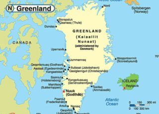
Covering an area of 2,166,086 sq. km (836,330 sq mi), Greenland (about 80% of which is ice-covered) is the world’s largest (non-continent) island, located between the Atlantic and Arctic Oceans.  As observed on the physical map of Greenland above, the coastline is rugged, mountainous, and for the most part, barren. The land then rises to a sloping … Read more

Map of Burundi

Map of Burundi

As shown on the map, the small landlocked country of Burundi is located on the northeastern shoreline of Lake Tanganyika. It occupies an area of 27,834 sq. km in Central-East Africa. Burundi has a largely hilly and mountainous terrain with the wooded Mitumba Mountains in the west giving way to a plateau eastwards. As marked … Read more

Map of Lesotho

Map of Lesotho

Lesotho is an enclave as it is surrounded by South Africa in Southern Africa. The country has an area of 30,000 sq. km. Lesotho is also unique in other ways. It is the only independent state in the world that lies entirely above 1,400 m in elevation. In fact, 80% of the country lies above … Read more

Map of Bhutan

Map of Bhutan

The Kingdom of Bhutan covers an area of 38,394 sq. km at the eastern limits of the Himalayas. The length of the country is only slightly larger than the width giving it a compact shape.  As observed on the physical map of Bhutan above, the country is highly mountainous. Here several peaks of the Himalayas … Read more

Map of Central African Republic

Map of Central African Republic

The Central African Republic is located in the heart of Africa where it occupies an area of 622,984 sq. km.  As observed on the physical map of the country above, a large part of it is covered by a flat or rolling plateau with an average elevation of about 500 m above sea level.  The … Read more

Map of Saint Lucia

Map of Saint Lucia

Volcanic in origin, Saint Lucia is one of the many small islands that comprise the Caribbean’s Windward Islands. Covering a total land area of 617 sq.km, St. Lucia’s landscape is dominated by dense jungle and a central ridge of forested mountains. St. Lucia is known around the world for the striking twin peaks of Gros … Read more

Map of Eritrea

Map of Eritrea

The East African country of Eritrea occupies an area of 117,600 sq. km with a coastline on the Red Sea to the east and northeast. As observed on the physical map above, one of the most notable physical features of Eritrea is the central highlands region which runs on a north-south axis through the middle … Read more

Map of Cape Verde

Map of Cape Verde

Cape Verde is an island country with an area of 4,033 sq. km in the central Atlantic Ocean. The physical map illustrates the physical characteristics of the country of Cape Verde. It is comprised of 9 inhabited islands, one uninhabited island, and various islets.  The islands are hilly and mountainous (all volcanic in origin), and … Read more

Map of Belize

Map of Belize

Belize, a country with an area of 22,966 sq. km (8,867 sq mi), is divided into four main geographic regions, including the relatively low Maya Mountains of the south that dominate all but the narrow coastal plain; the northern limestone lowlands and its many rivers and streams; the flat and swampy coastal plain, and the almost countless … Read more

Map of Gambia

Map of Gambia

As observed on the physical map of the country, The Gambia is a very small and narrow country whose borders seem to follow the path of the meandering Gambia River, and at less than 30 miles wide at its widest point, nearly 10% of the country’s land area is covered by water. The Gambia River … Read more

Map of Antigua & Barbuda

Map of Antigua & Barbuda

Covering an area of only 440 sq. km, the dual-island nation of Antigua and Barbuda are positioned in the Caribbean’s Lesser Antilles and help to separate the Atlantic Ocean from the Caribbean Sea. As observed on the map, both islands are relatively low-lying limestone formations; and are ringed by reefs and sandbars, and indented by … Read more

Map of Seychelles

Map of Seychelles

The small island country of Seychelles is an archipelago of over 100 islands and has a total land area of only 452 sq. km. However, the islands of the country are spread far and wide forming an Exclusive Economic Zone that covers a total area of 1,336,559 sq. km.  The country has two major island … Read more