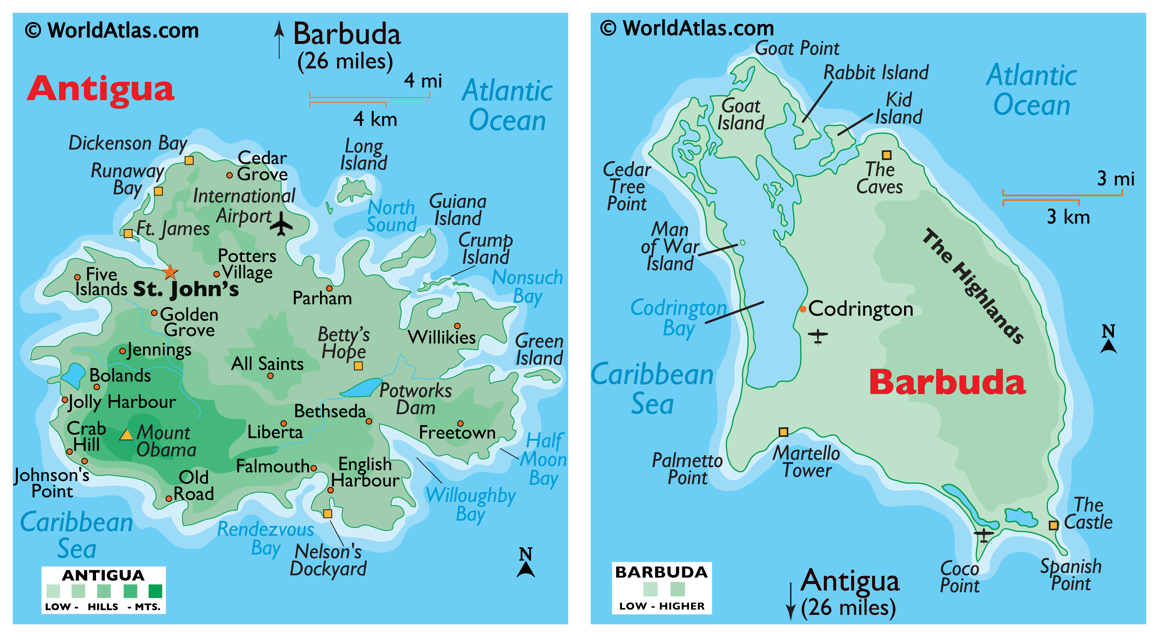
Covering an area of only 440 sq. km, the dual-island nation of Antigua and Barbuda are positioned in the Caribbean’s Lesser Antilles and help to separate the Atlantic Ocean from the Caribbean Sea.
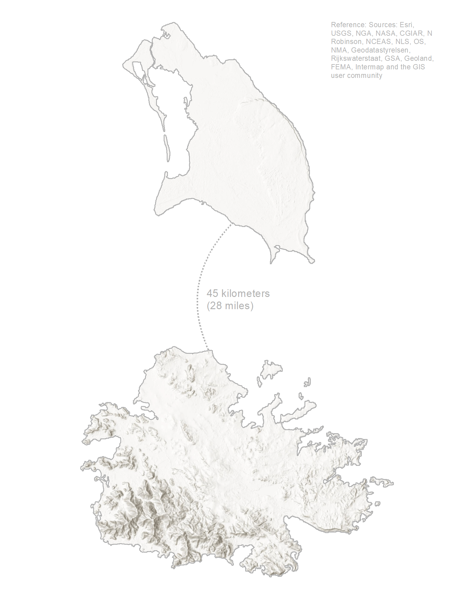
As observed on the map, both islands are relatively low-lying limestone formations; and are ringed by reefs and sandbars, and indented by beaches, small lagoons, and natural harbors. The highest point, as marked on the map, by an upright yellow triangle, is Mount Obama (formerly Boggy Peak), which is located in the hilly region of southwestern Antigua; and is a remnant of a volcanic crater that rises to 405m. There are no rivers of note and only a few streams are present, as rainfall amounts are quite light. The lowest point is the Caribbean Sea (0m).
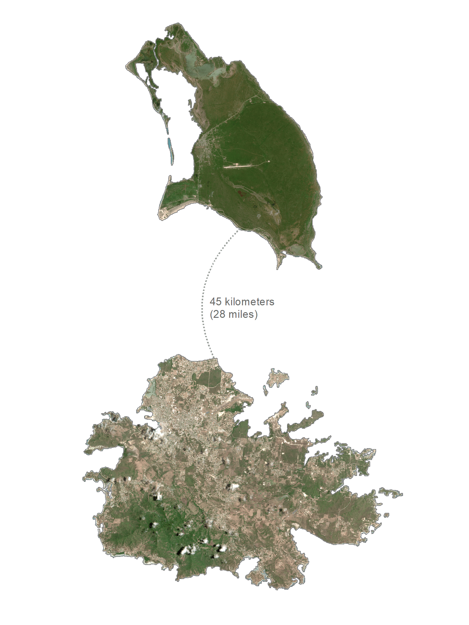
Situated about 63km north of Antigua Island is Barbuda – which is mainly a flat and tree-covered coral island. The highest elevation is 44.5 m (146 ft), and a part of the highland plateau on the eastern edge of the island. The most noteworthy landform of Barbuda’s coastline is the Codrington Bay natural lagoon on the western side of the island.
| Flag: |  |
|---|---|
| Legal Name: | Antigua and Barbuda |
| Capital Value: | Saint John’s |
| Demonym(s): | Antiguan and Barbudan Antiguan Barbudan |
| Government: | Unitary dominant-party parliamentary constitutional monarchy |
| Legislature: | Parliament |
| Total Area: | 442 km² |
| Land Area: | 442 km² |
| Population: | 97,118 |
| Density: | 186/km (481.7/sq mi) |
| GDP: | $1.73 Billion |
| GDP Per Capita: | $17,790.31 |
| Currency Value: | East Caribbean dollars (XCD) |
| Driving side: | left |
| Calling code: | +1-268 |
| Internet TLD: | .ag |
Explore the islands of Antigua and Barbuda with this interactive map! Discover the stunning beaches, picturesque towns, and winding roads of the two Caribbean islands. You can also view a satellite and elevation map to get an idea of the topography, including the Barbuda Highlands and Boggy Peak.
Online Interactive Political Map
Click on ![]() to view map in "full screen" mode.
to view map in "full screen" mode.
Antigua and Barbuda are divided into 6 parishes and two dependencies. The 6 parishes are Saint George, Saint John, Saint Mary, Saint Paul, Saint Peter, and Saint Philip. The two dependencies are Barbuda and Redonda.
Covering an area of only 440 sq. km, the dual-island nation of Antigua and Barbuda consists of the two principal islands of Antigua and Barbuda which are inhabited; along with several smaller islands and the Redonda island which is still uninhabited. Located on the north-western coast of Antigua Island is St. John’s – the capital and the largest city of Antigua and Barbuda. It is also the chief commercial center of the island nation and the main port of Antigua. Located on Barbuda island is Codrington – which is the largest town of Barbuda.
Location Maps
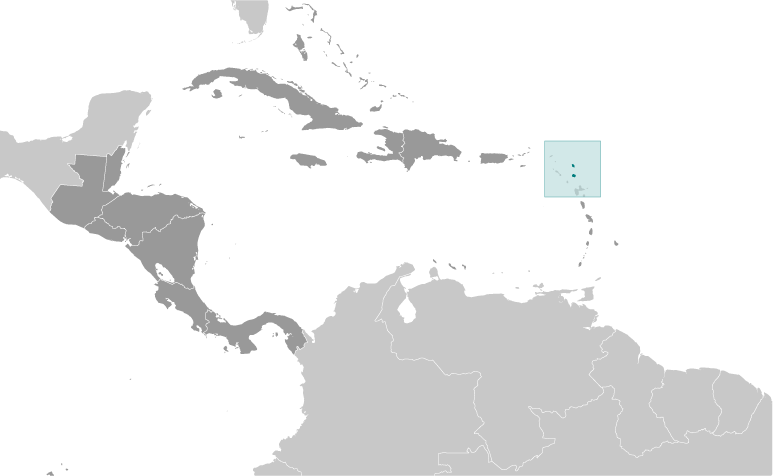
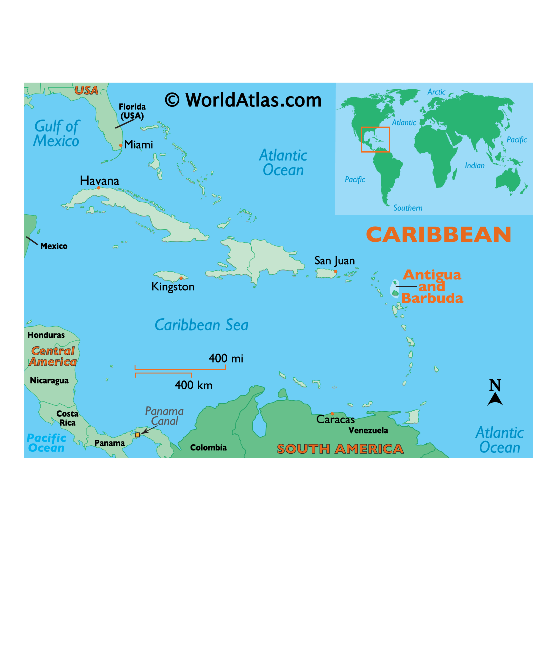
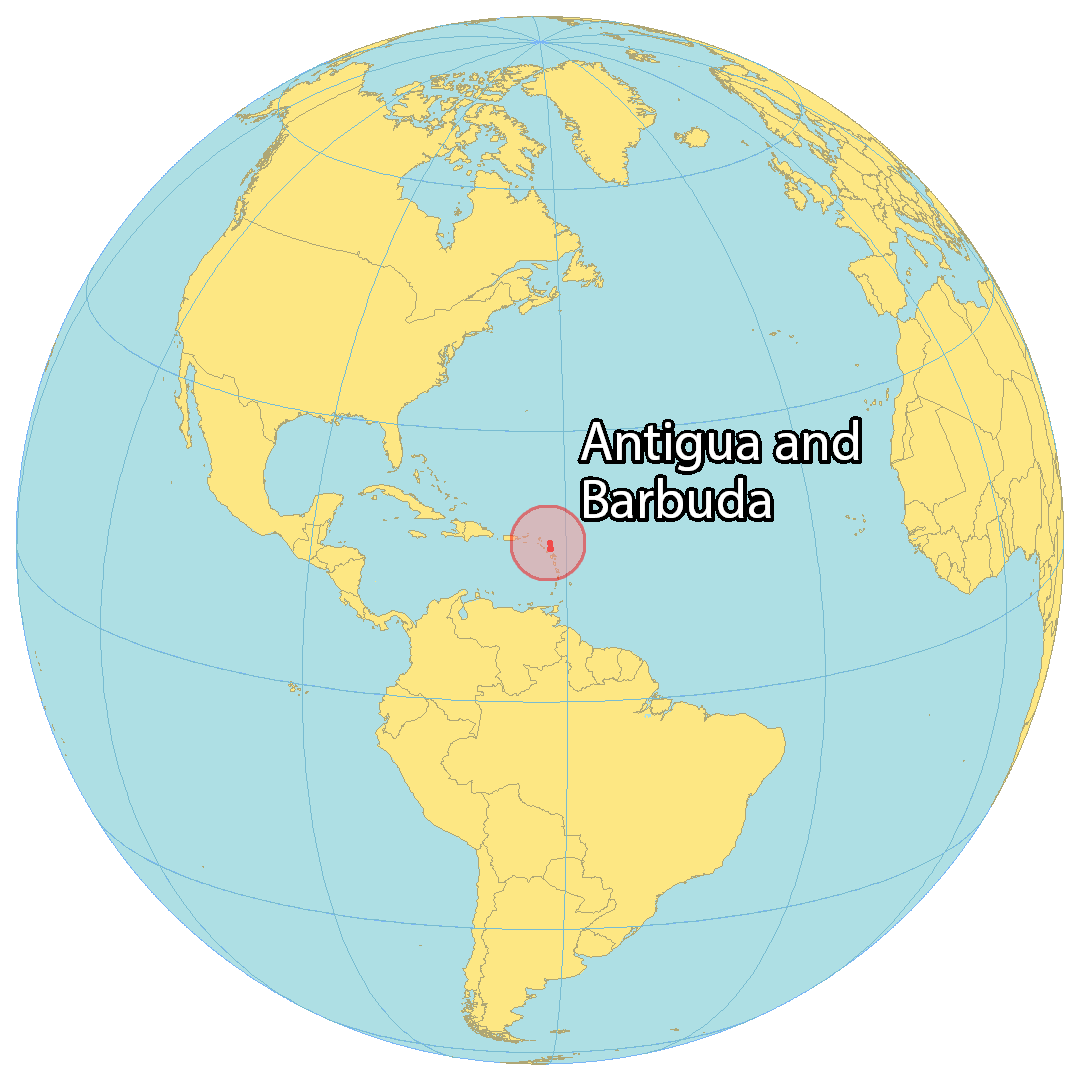
Where is Antigua & Barbuda?
Antigua and Barbuda is a Caribbean Sea country consisting of two main islands: Antigua in the south and Barbuda in the north. Antigua is the main island and home to the capital and largest city of Saint John’s. Barbuda is known for its coral reefs and beaches. The country is close to Guadeloupe to the south, Montserrat to the southwest, and Saint Kitts and Nevis to the west. In 1981, Antigua and Barbuda gained their independence from the British, but English remains the official language due to the British influence. The vast majority of people live in Antigua, while only 2000 people live in Barbuda.
High Definition Political Map of Antigua & Barbuda


History
Pre-colonial period
Antigua was first settled by archaic age hunter-gatherer Amerindians called the Ciboney. Carbon dating has established the earliest settlements started around 3100 BC. They were succeeded by the ceramic age pre-Columbian Arawak-speaking Saladoid people who migrated from the lower Orinoco River. They introduced agriculture, raising, among other crops, the famous Antigua black pineapple (Ananas comosus), corn, sweet potatoes, chiles, guava, tobacco, and cotton. Later on the more bellicose Caribs also settled the island, possibly by force.
European arrival and settlement
Christopher Columbus was the first European to sight the islands in 1493. The Spanish did not colonise Antigua until after a combination of European and African diseases, malnutrition, and slavery eventually extirpated most of the native population; smallpox was probably the greatest killer.
The English settled on Antigua in 1632; Christopher Codrington settled on Barbuda in 1685. Tobacco and then sugar was grown, worked by a large population of slaves transported from West Africa, who soon came to vastly outnumber the European settlers.
Colonial era
The English maintained control of the islands, repulsing an attempted French attack in 1666. The brutal conditions endured by the slaves led to revolts in 1701 and 1729 and a planned revolt in 1736, the last led by Prince Klaas, though it was discovered before it began and the ringleaders were executed. Slavery was abolished in the British Empire in 1833, affecting the economy. This was exacerbated by natural disasters such as the 1843 earthquake and the 1847 hurricane. Mining occurred on the isle of Redonda, however, this ceased in 1929 and the island has since remained uninhabited.
Part of the Leeward Islands colony, Antigua and Barbuda became part of the short-lived West Indies Federation from 1958 to 1962. Antigua and Barbuda subsequently became an associated state of the United Kingdom with full internal autonomy on 27 February 1967. The 1970s were dominated by discussions as to the islands’ future and the rivalry between Vere Bird of the Antigua and Barbuda Labour Party (ABLP) (Premier from 1967 to 1971 and 1976 to 1981) and the Progressive Labour Movement (PLM) of George Walter (Premier 1971–1976). Eventually, Antigua and Barbuda gained full independence on 1 November 1981; Vere Bird became prime minister of the new country. The country opted to remain within the Commonwealth, retaining Queen Elizabeth as head of state, with the last governor, Sir Wilfred Jacobs, as governor-general.
Independence era
The first two decades of Antigua’s independence were dominated politically by the Bird family and the ABLP, with Vere Bird ruling from 1981 to 1994, followed by his son Lester Bird from 1994 to 2004. Though providing a degree of political stability, and boosting tourism to the country, the Bird governments were frequently accused of corruption, cronyism and financial malfeasance. Vere Bird Jr., the elder son, was forced to leave the cabinet in 1990 following a scandal in which he was accused of smuggling Israeli weapons to Colombian drug-traffickers. Another son, Ivor Bird, was convicted of selling cocaine in 1995.
In 1995, Hurricane Luis caused severe damage on Barbuda.
The ABLP’s dominance of Antiguan politics ended with the 2004 Antiguan general election, which was won by Winston Baldwin Spencer’s United Progressive Party (UPP). Winston Baldwin Spencer was Prime Minister of Antigua and Barbuda from 2004 to 2014. However the UPP lost the 2014 Antiguan general election, with the ABLP returning to power under Gaston Browne. ABLP won 15 of the 17 seats in the 2018 snap election under the leadership of incumbent Prime Minister Gaston Browne.
In 2016, Nelson’s Dockyard was designated as a UNESCO World Heritage Site.
Most of Barbuda was devastated in early September 2017 by Hurricane Irma, which brought winds with speeds reaching 295 km/h (185 mph). The storm damaged or destroyed 95% of the island’s buildings and infrastructure, leaving Barbuda “barely habitable” according to Prime Minister Gaston Browne. Nearly everyone on the island was evacuated to Antigua. Amidst the following rebuilding efforts on Barbuda that were estimated to cost at least $100 million, the government announced plans to revoke a century-old law of communal land ownership by allowing residents to buy land; a move that has been criticised as promoting “disaster capitalism”.
Physical Map of Antigua & Barbuda

Geography
Limestone formations, rather than volcanic activity, have had the most impact on the topography of both Antigua and Barbuda, which are both relatively low-lying islands. Boggy Peak, also known as Mt. Obama from 2008 to 2016, is the highest point on both Antigua and Barbuda. It is the remnant of a volcanic crater and rises a total of 402 meters. Boggy Peak is located in the southwest of Antigua (1,319 feet).
Both of these islands have very irregularly shaped coastlines that are dotted with beaches, lagoons, and natural harbors. There are reefs and shoals that surround the islands on all sides. Because of the low amount of rainfall, there are not many streams. On neither of these islands can sufficient quantities of fresh groundwater be found.
Redonda is a small, uninhabited island located about 40 kilometers (25 miles) to the south-west of Antigua. Redonda is a rocky island.
Cities and villages
The most populous cities in Antigua and Barbuda are mostly on Antigua, being Saint John’s, All Saints, Piggotts, and Liberta. The most populous city on Barbuda is Codrington. It is estimated that 25% of the population lives in an urban area, which is much lower than the international average of 55%.
Islands
Antigua and Barbuda consists mostly of its two namesake islands, Antigua, and Barbuda. Other than that, Antigua and Barbuda’s biggest islands are Guiana Island and Long Island off the coast of Antigua, and Redonda island, which is far from both of the main islands.
Climate
Rainfall averages 990 mm (39 in) per year, with the amount varying widely from season to season. In general the wettest period is between September and November. The islands generally experience low humidity and recurrent droughts. Temperatures average 27 °C (80.6 °F), with a range from 23 °C (73.4 °F) to 29 °C (84.2 °F) in the winter to from 25 °C (77.0 °F) to 30 °C (86.0 °F) in the summer and autumn. The coolest period is between December and February.
Hurricanes strike on an average of once a year, including the powerful Category 5 Hurricane Irma, on 6 September 2017, which damaged 95% of the structures on Barbuda. Some 1,800 people were evacuated to Antigua.
An estimate published by Time indicated that over $100 million would be required to rebuild homes and infrastructure. Philmore Mullin, Director of Barbuda’s National Office of Disaster Services, said that “all critical infrastructure and utilities are non-existent – food supply, medicine, shelter, electricity, water, communications, waste management”. He summarised the situation as follows: “Public utilities need to be rebuilt in their entirety… It is optimistic to think anything can be rebuilt in six months … In my 25 years in disaster management, I have never seen something like this.”
Environmental issues
Like other island nations, Antigua and Barbuda faces unique environmental issues created by its proximity to the ocean, and small size. These include pressures on water resources, natural ecosystems, and deforestation more generally.
Existing issues on the island are further made worse by climate change, where, unlike other island nations affected by climate change, sea level rise, increased weather variability, create increased pressures on the communities on the islands and the land, through processes like coastal erosion and saltwater intrusion.
Antigua & Barbuda Satellite Map
Elevation Map