Map of Timor-Leste

Map of Timor-Leste

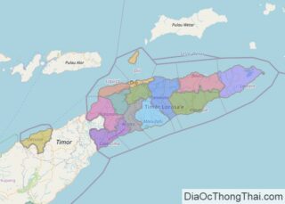
Sharing the island of Timor with West Timor of Indonesia, Timor-Leste, also called East Timor, is a sovereign nation with a total area of about 15,007 sq. km. As shown on the physical map of the country above, East Timor also includes several islands like Atauro and Jaco. It also has an enclave of Ambeno … Read more

Map of San Marino

Map of San Marino

With its land area covering only 24 sq miles (61 sq km), San Marino is one of the smallest countries in Europe after the Vatican and Monaco.Landlocked and surrounded by Italy, the country is in the Appennines Mountains region, with most of it on the slopes of Mt. Titano. At 2,477 feet (755 m) Monte … Read more

Map of Solomon Islands

Map of Solomon Islands

Covering an area of 28,400 sq.km (11,000 sq mi), Solomon Islands are an archipelagic state comprising of a double chain of 992 volcanic islands and coral atolls in Melanesia, located in southwest Pacific Ocean. Extending about 900 miles (1,448km) in total length, the Solomon Islands are a wide-spread archipelago of mountainous, heavily forested volcanic islands (some active) … Read more

Map of Guinea Bissau

Map of Guinea Bissau

Guinea-Bissau is a West African country with an area of 36,125 sq. km. As observed on the physical map of the country, it has a coastline on the Atlantic Ocean. Most of Guinea-Bissau is low-lying. The coastal plains with Guinean mangrove swamps lead to flat savanna and forests inland. Due to the flat nature of … Read more

Map of Northern Mariana Islands

Map of Northern Mariana Islands

Covering a total land area of 475.26 sq.km (179 sq mi), Northern Mariana Islands is an unincorporated and organized territory of the United States and also a U.S. commonwealth. The territory comprises of 15 islands in the Mariana archipelago situated in the northwestern Pacific Ocean. The Northern islands are volcanic in origin. Several islands like Anatahan, Pagan … Read more

Map of Grenada

Map of Grenada

Covering a total area of only 348.5 sq. km (134.6 sq mi), the country of Grenada consists of the main island of Grenada, the larger islands of Carriacou and Petit Martinique, and some 600 small islets, mostly uninhabited.  The islands of the country of Grenada are all volcanic in origin and vary in elevation from 300m (984ft), … Read more

Map of Comoros

Map of Comoros

The physical map above illustrates the country of Comoros which is volcanic in origin. The islands occupy an area of 2,034 sq. km. As observed on the map, four main islands comprise the archipelago of Comoros. These islands are arranged along a northwest-southeast axis at the Mozambique Channel’s northern end. The Comoros islands evoke a … Read more

Map of Saint Kitts & Nevis

Map of Saint Kitts & Nevis

Saint Kitts and Nevis is a twin island country covering an area of 261 sq. km (101 sq mi). It is located in the eastern Caribbean Sea. The dual island nation of Saint Kitts and Nevis is the smallest sovereign nation in the Western hemisphere. Both islands are actually the summits of a submerged volcanic mountain range.  … Read more

Map of Turks and Caicos

Map of Turks and Caicos

The Turks and Caicos Islands are a British Overseas Territory and comprises of two groups of tropical islands in the Lucayan archipelago, to the north of the Caribbean Sea. Covering a total land area of 616.3 sq. km (238.0 sq mi), the territory comprises of the smaller Turks Islands and the larger Caicos Islands as observed on the … Read more

Map of Vanuatu

Map of Vanuatu

Covering a total land area of 12,189 sq.km (4,706 sq mi), Vanuatu is a Melanesian archipelago comprising of a double chain of 13 principal (larger islands) and about 70 smaller islands located in the South Pacific Ocean as observed on the physical map of Vanuatu above. The terrain of Vanuatu is diverse and is famed for its … Read more

Map of Samoa

Map of Samoa

Covering an area of 2,842 sq.km (1,097 sq mi), Samoa is a Polynesian island nation comprising of two large islands of Saval ‘I and Upolu and 8 small islets namely, Manono Island, Apolima and Nu’ulopa; Nu’utele, Nu’ulua, Namua and Fanuatapu; and Nu’usafe’e; located in the South Pacific Ocean. Savai’i is Samoa’s largest island occupying about 1,707 sq.km … Read more

Map of Saint Vincent & the Grenadines

Map of Saint Vincent & the Grenadines

St. Vincent and the Grenadines are a group of islands located in the Caribbean Sea and the North Atlantic Ocean. Covering a total area of 389 sq. km (150 sq mi), the island country of St. Vincent and the Grenadines comprises of the larger St. Vincent Island and the northern Grenadine islands, along with some 32 islands … Read more