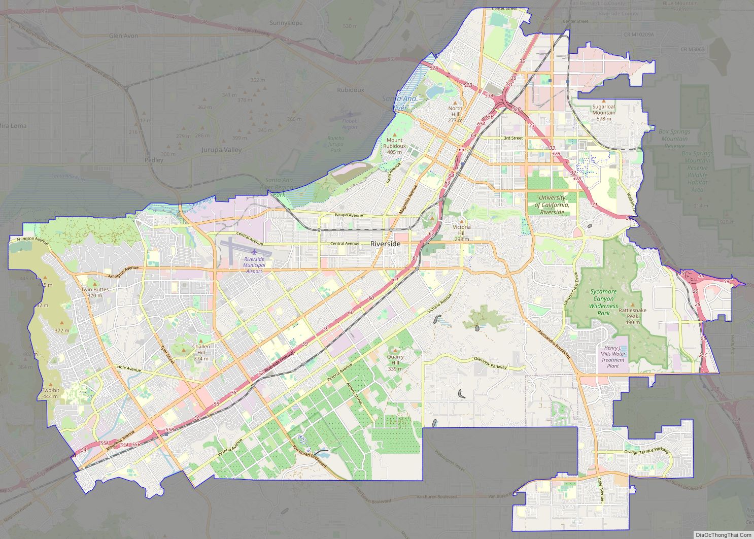
Map of Irvine city

Map of Irvine city, California

Irvine (/ˈɜːrvaɪn/) is a master-planned city in southern Orange County, California, United States, in the Los Angeles metropolitan area. The Irvine Company started developing the area in the 1960s and the city was formally incorporated on December 28, 1971. The 66-square-mile (170 km) city had a population of 307,670 at the 2020 census. A number of … Read more

Map of Chula Vista city

Map of Chula Vista city, California

Chula Vista (Spanish for ‘Beautiful View’; /ˌtʃuːlə ˈvɪstə/) is the second-largest city in the San Diego metropolitan area, the seventh largest city in Southern California, the fifteenth largest city in the state of California, and the 78th-largest city in the United States. The population was 275,487 as of the 2020 census, up from 243,916 as … Read more

Map of San Bernardino city

Map of San Bernardino city

San Bernardino (/ˌsæn ˌbɜːrnəˈdiːnoʊ/; Spanish for “Saint Bernardino”) is a city and county seat of San Bernardino County, California, United States. Located in the Inland Empire region of Southern California, the city had a population of 222,101 in the 2020 census, making it the 18th-largest city in California. San Bernardino is the economic, cultural, and … Read more

Map of Santa Clarita city

Map of Santa Clarita city

Santa Clarita (/ˌsæntə kləˈriːtə/; Spanish for “Little St. Clare”) is a city in northwestern Los Angeles County in the U.S. state of California. With a 2020 census population of 228,673, it is the third-largest city by population in Los Angeles County, the 17th-largest in California, and the 99th-largest city in the United States. It is … Read more

Map of Fremont city

Map of Fremont city, California

Fremont city overview: Name: Fremont city LSAD Code: 25 LSAD Description: city (suffix) State: California County: Alameda County Incorporated: January 23, 1956 Elevation: 56 ft (17 m) Total Area: 88.46 sq mi (229.10 km²) Land Area: 78.31 sq mi (202.83 km²) Water Area: 10.14 sq mi (26.27 km²)  11.6% Total Population: 230,504 Population Density: 2,600/sq mi (1,000/km²) ZIP code: 94536–94539, 94555 Area code: 510, 341 FIPS code: … Read more

Map of Modesto city

Map of Modesto city, California

Modesto (Spanish pronunciation: [moˈdesto]) is the county seat and largest city of Stanislaus County, California, United States. With a population of 218,464 at the 2020 census, it is the 19th largest city in the state of California. Modesto is located in the Central Valley, 68 miles (109 km) south of Sacramento and 90 miles (140 km) north of … Read more

Map of Fontana city

Map of Fontana city, California

Fontana is a city in San Bernardino County, California, United States. Founded by Azariel Blanchard Miller in 1913, it remained essentially rural until World War II, when entrepreneur Henry J. Kaiser built a large steel mill in the area. It is now a regional hub of the trucking industry, with the east–west Interstate 10 and … Read more

Map of Moreno Valley city

Map of Moreno Valley city

Moreno Valley is a city in Riverside County, California, United States, and is part of the Riverside–San Bernardino–Ontario metropolitan area. It is the second-largest city in Riverside County by population and one of the Inland Empire’s population centers. The city’s population was 208,634 at the 2020 census. Moreno Valley is also part of the larger … Read more

Map of Oxnard city

Map of Oxnard city

Oxnard (/ˈɒksnɑːrd/ (listen)) is a city in Ventura County, California, United States. On California’s South Coast, it is the most populous city in Ventura County and the 22nd-most-populous city in California. Incorporated in 1903, Oxnard lies approximately 60 miles (97 km) west of downtown Los Angeles and is part of the larger Greater Los Angeles area. … Read more

Map of Huntington Beach city

Map of Huntington Beach city

Huntington Beach is a seaside city in Orange County in Southern California, United States. The city is named after American businessman Henry E. Huntington. The population was 198,711 during the 2020 census, making it the fourth most populous city in Orange County, the most populous beach city in Orange County, and the seventh most populous … Read more

Map of Glendale city, California

Map of Glendale city, California

Glendale is a city in the San Fernando Valley and Verdugo Mountains regions of Los Angeles County, California, United States. At the 2020 U.S. Census the population was 196,543, up from 191,719 at the 2010 census, making it the fourth-largest city in Los Angeles County and the 24th-largest city in California. It is located about … Read more