Moreno Valley is a city in Riverside County, California, United States, and is part of the Riverside–San Bernardino–Ontario metropolitan area. It is the second-largest city in Riverside County by population and one of the Inland Empire’s population centers. The city’s population was 208,634 at the 2020 census. Moreno Valley is also part of the larger greater Los Angeles area.
The city derived its name from the small community of Moreno, which became part of the city of Moreno Valley when the city was incorporated in 1984. Frank E. Brown, one of the founders of the community of Moreno in 1882, declined to have the town named after him, but to honor him, the town was named Moreno, Spanish for brown.
| Name: | Moreno Valley city |
|---|---|
| LSAD Code: | 25 |
| LSAD Description: | city (suffix) |
| State: | California |
| County: | Riverside County |
| Incorporated: | December 3, 1984 |
| Elevation: | 1,631 ft (497 m) |
| Total Area: | 51.51 sq mi (133.41 km²) |
| Land Area: | 51.30 sq mi (132.86 km²) |
| Water Area: | 0.21 sq mi (0.55 km²) 0.39% |
| Total Population: | 208,634 |
| Population Density: | 4,153.36/sq mi (1,603.62/km²) |
| ZIP code: | 92551–92557 |
| FIPS code: | 0649270 |
| Website: | www.moval.org/index.shtml |
Online Interactive Map
Click on ![]() to view map in "full screen" mode.
to view map in "full screen" mode.
Moreno Valley location map. Where is Moreno Valley city?


History
Indigenous period
The Moreno Valley area was first inhabited 2,300 years ago. There are at least 200 prehistoric archaeological locations within the city. The majority of the sites are milling stations – where chaparral seed was the dominant milling activity. Rock art, consisting of pictographs, and petroglyphs are present – though most of the petroglyphs in Moreno Valley consist of boulders with “cupules”, or cup-shaped holes pecked into them.
Spanish & Mexican periods
Spanish scouts initially came across descendants of the Shoshone, and Luiseño tribes; although other groups, such as the Serrano and Cahuilla were in the area. The late prehistoric Luiseño and Cahuilla were semi-sedentary, meaning that they wintered in villages, then spread out in family groups during the spring and summer months to harvest seeds and acorns.
Spanish scouts blazed a number of trails in the area, including the Anza Trail, which runs through the Edgemont area of present-day Moreno Valley.
Post-Conquest period
When California was admitted to the United States as a state in 1850, Americans began to move into the area. The Tucson-to-San Francisco route of John Butterfield’s Overland Mail Company passed through it. Some farmers began to occupy the area, relying upon water from Frank E. Brown’s Bear Valley Land and Water Company. Beginning in 1883, the company collected and pumped water from Bear Valley in the San Bernardino Mountains to the north. The area first acquired its current name, Moreno Valley, at this time, referring to Frank Brown (moreno is Spanish for “brown” or “brunet”). In 1899, the city of Redlands won a lawsuit in which the city claimed eminent domain over the Bear Valley water. The resulting loss of service forced most of the area’s inhabitants to move.
20th century
The revival of the Moreno Valley area began in 1918, when the United States Air Force (then the United States Army Air Service) constructed March Field on the outskirts of Riverside as part of its World War I expansion. March Field was initially used to train fighter pilots. Although it was closed in 1922, it was reopened in 1927 and eventually became a full Air Force base. The presence of March caused the unincorporated communities of Sunnymead, Moreno, and Edgemont to develop and grow. In World War II, March again became a training ground for military pilots. On April 1, 1996, March Air Force Base (MAFB) became March Joint Air Reserve Base (MJARB) under Air Force Reserve Command (AFRC).
From September 22, 1957, to July 3, 1989, the Riverside International Raceway (sometimes known as RIR, Riverside or Riverside Raceway) occupied the current site of the Moreno Valley Mall. Some of the races held at RIR included IMSA, NASCAR, Indycar, NHRA drag racing, Go Karts, Formula 1, and AMA motorcycle racing. When there was no racing, Riverside was used in TV shows, movies, advertisements and was used by both Carroll Shelby and Skip Barber to teach students how to drive around the track. The mall is now located where turns 5, 6 (NASCAR Road) and 8 used to be on the northern end near the freeway and houses now occupy the southern end of the raceway’s property.
By 1984, the population was 49,702 (compared to 18,871 residents in 1970). The state economic boom fueled the construction of new houses and businesses, leading to a push for the area to incorporate as a city. Although similar measures had failed previously in 1968 and 1983, the measure to form the city of Moreno Valley was approved by the area’s voters in 1984. On December 3, 1984, the communities of Edgemont, Sunnymead, and Moreno united along with nearby areas to form the general law city of Moreno Valley. The first city council was also elected in 1984. It was composed of Bob Lynn, Judith A. Nieburger, Steven Webb, J. David Horspool (first Mayor Pro Tem), and Marshall C. Scott (first Mayor). The city seal and motto were adopted the following year.
By 1990, Moreno Valley had grown to become the second-largest city in Riverside County with a population of approximately 118,000. This growth continued until about 1992.
In the 1990s, the Moreno Valley economy deteriorated. Many residents began to leave the city. March Air Force Base was also downsized to its present status as March Air Reserve Base. The surplus land was given to the March Joint Powers Authority, made up of representatives of Riverside County, and the cities of Riverside, Moreno Valley, and Perris for development. The dismal economic trend began to reverse in the late part of the decade and companies such as Aurora Modular, U-Haul, and Lowe’s moved major operating facilities to the city or neighboring cities (although Aurora later filed for bankruptcy).
By the early 2000s, the soaring cost of living in nearby Los Angeles County and Orange County helped make the less developed portions of the Inland Empire an attractive place for business and home construction.
Proposals to turn March Joint Air Reserve Base to a major commercial airport were debated in 2005, which would have given the Inland Empire a second commercial airport; there is currently a commercial airport in the city of Ontario. However, the plan was rejected by the Riverside County Board of Supervisors. In May 2008, the March Joint Powers Authority approved the facility for small general private aircraft.
DHL selected March Air Reserve Base as its Southern California hub and commenced operations in October 2005. While initial claims were that the facility would employ 250 workers in its initial stage, over 300 employees went to work daily during normal operations. In November 2008, DHL announced it was leaving the U.S. market and would shut its operation associated with March Air Field in January 2009.
March Air Reserve base has a ball park facility, where the semi-pro baseball Rancho Belago Rockets of the Southern California League play in the summer months.
21st century
On February 13, 2007, the city council passed, by a vote of 4–1, a resolution christening the eastern half of the city (roughly from Lasselle Street to Gilman Springs Road) “Rancho Belago”, a pastiche of Spanish and Italian words. The city council’s resolution includes the 92555 ZIP Code within the boundaries of the area, as reported by the Press Enterprise newspaper.
Metrolink rail transit arrived in the area in 2016, as far south as Perris. A proposal to erect a four-lane road (known as Mid County Parkway) near the site of Cajalco Road/Ramona Expressway from Interstate 215 to State Route 79 in San Jacinto is currently being studied by Caltrans and Riverside County.
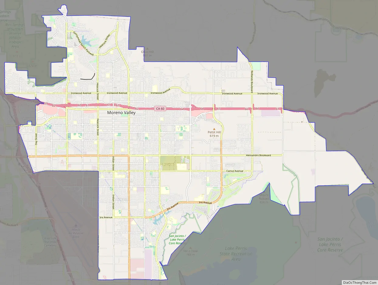
Moreno Valley Road Map
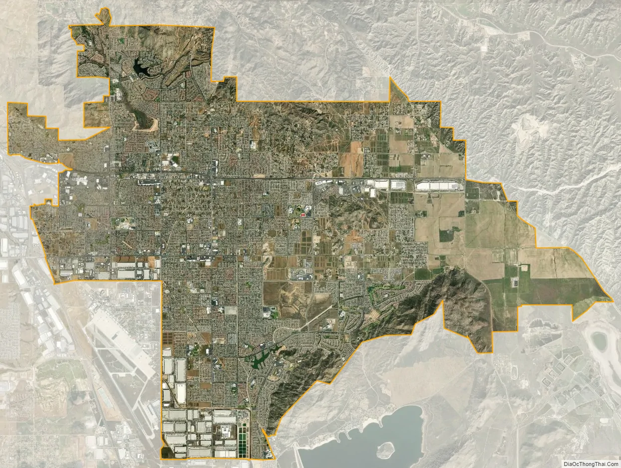
Moreno Valley city Satellite Map
Geography
According to the United States Census Bureau, the city has a total area of 51.5 square miles (133 km), of which, 51.3 square miles (133 km) of it is land and 0.2 square miles (0.52 km) of it is water.
Moreno Valley is located at a geographic crossroad. To the east lies the San Gorgonio Pass and Coachella Valley; to the south are Lake Perris, Perris, and the San Jacinto Mountains; to the north are the San Bernardino Valley and San Bernardino Mountains. To the west lies neighboring Riverside. It is relatively close to Ontario International Airport.
One of the most visible geographical features in Moreno Valley is Box Springs Mountain. This mountain at the northwest end of the city rises over the city, providing a concrete landmark. The section of the mountain that faces the city has a large letter “M” constructed upon it. This was built privately at the encouragement of the city council, which argued it would foster unity. The letter is located on public land and is maintained entirely by charity. The letter had lights installed on December 3, 2005 to celebrate Moreno Valley’s 21st anniversary of its incorporation. The completion of the repairs of heavy damage to the letter, due to extreme rain the year before. The mayor at that time, Bonnie Flickinger, has said that the citizens liked it that way and that the council would try to get it to light up regularly. Between December 2, 2009 and December 6, 2009, Moreno Valley, along with Edison lit up the letter in celebration of the city’s 25th anniversary. Several Eagle Scout projects have been dedicated to maintaining the “M”.
See also
Map of California State and its subdivision:- Alameda
- Alpine
- Amador
- Butte
- Calaveras
- Colusa
- Contra Costa
- Del Norte
- El Dorado
- Fresno
- Glenn
- Humboldt
- Imperial
- Inyo
- Kern
- Kings
- Lake
- Lassen
- Los Angeles
- Madera
- Marin
- Mariposa
- Mendocino
- Merced
- Modoc
- Mono
- Monterey
- Napa
- Nevada
- Orange
- Placer
- Plumas
- Riverside
- Sacramento
- San Benito
- San Bernardino
- San Diego
- San Francisco
- San Joaquin
- San Luis Obispo
- San Mateo
- Santa Barbara
- Santa Clara
- Santa Cruz
- Shasta
- Sierra
- Siskiyou
- Solano
- Sonoma
- Stanislaus
- Sutter
- Tehama
- Trinity
- Tulare
- Tuolumne
- Ventura
- Yolo
- Yuba
- Alabama
- Alaska
- Arizona
- Arkansas
- California
- Colorado
- Connecticut
- Delaware
- District of Columbia
- Florida
- Georgia
- Hawaii
- Idaho
- Illinois
- Indiana
- Iowa
- Kansas
- Kentucky
- Louisiana
- Maine
- Maryland
- Massachusetts
- Michigan
- Minnesota
- Mississippi
- Missouri
- Montana
- Nebraska
- Nevada
- New Hampshire
- New Jersey
- New Mexico
- New York
- North Carolina
- North Dakota
- Ohio
- Oklahoma
- Oregon
- Pennsylvania
- Rhode Island
- South Carolina
- South Dakota
- Tennessee
- Texas
- Utah
- Vermont
- Virginia
- Washington
- West Virginia
- Wisconsin
- Wyoming


