Huntington Beach is a seaside city in Orange County in Southern California, United States. The city is named after American businessman Henry E. Huntington. The population was 198,711 during the 2020 census, making it the fourth most populous city in Orange County, the most populous beach city in Orange County, and the seventh most populous city in the Los Angeles-Long Beach-Anaheim, CA Metropolitan Statistical Area. Located 35 miles (56 km) southeast of Downtown Los Angeles, it is bordered by Bolsa Chica Basin State Marine Conservation Area on the west, the Pacific Ocean on the southwest, by Seal Beach on the northwest, by Westminster on the north, by Fountain Valley on the northeast, by Costa Mesa on the east, and by Newport Beach on the southeast.
Huntington Beach is known for its long 9.5-mile (15.3 km) stretch of sandy beach, mild climate, excellent surfing, and beach culture. Swells generated predominantly from the North Pacific in winter and from a combination of Southern Hemisphere storms and hurricanes in the summer focus on Huntington Beach, creating consistent surf all year long, hence the nickname “Surf City”.
| Name: | Huntington Beach city |
|---|---|
| LSAD Code: | 25 |
| LSAD Description: | city (suffix) |
| State: | California |
| County: | Orange County |
| Incorporated: | February 17, 1909 |
| Elevation: | 39 ft (12 m) |
| Total Area: | 28.33 sq mi (73.38 km²) |
| Land Area: | 27.00 sq mi (69.92 km²) |
| Water Area: | 1.33 sq mi (3.46 km²) 16.10% |
| Total Population: | 198,711 |
| Population Density: | 7,000/sq mi (2,700/km²) |
| ZIP code: | 92605, 92615, 92646–92649 |
| FIPS code: | 0636000 |
| Website: | huntingtonbeachca.gov |
Online Interactive Map
Click on ![]() to view map in "full screen" mode.
to view map in "full screen" mode.
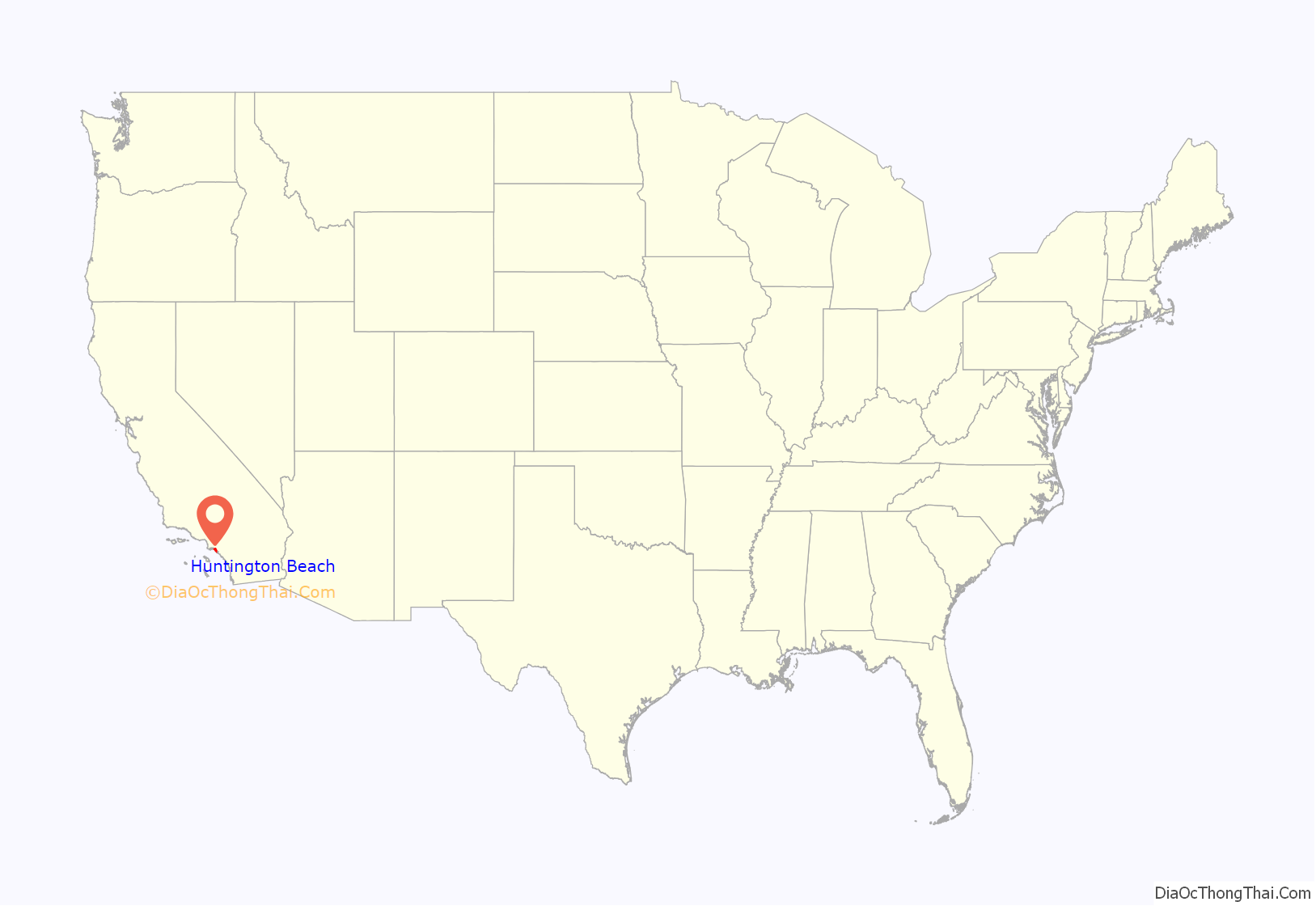
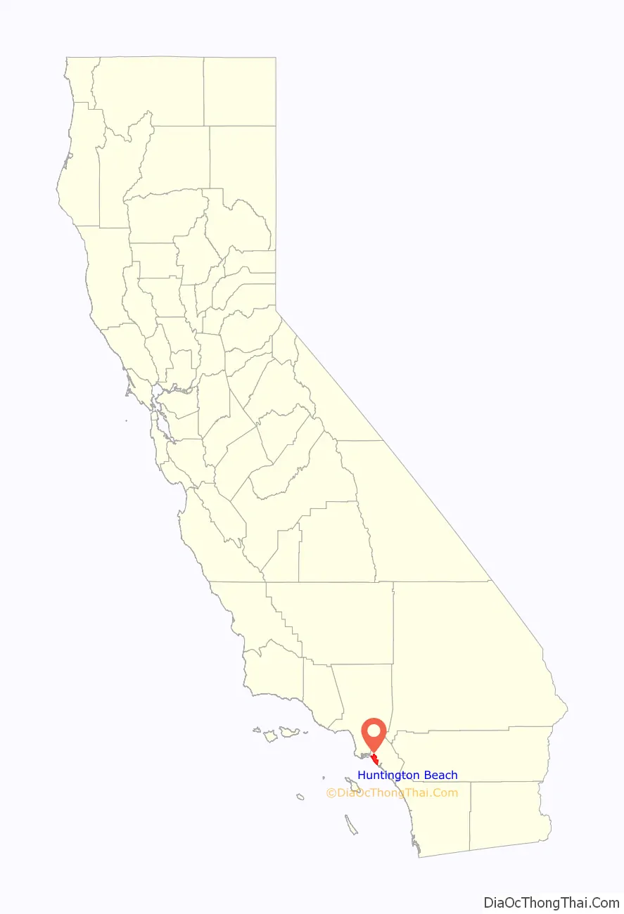
Huntington Beach location map. Where is Huntington Beach city?
History
The Tongva village of Lupukngna was located in what is now Huntington Beach, with an approximate location being near the Newland House Museum. The nearby village of Genga, shared with the Acjachemen, was located across the Santa Ana River in what is now Newport Beach and Costa Mesa.
The main thoroughfare of Huntington Beach, Beach Boulevard, was originally a cattle route for the main industry of the Rancho. Since its time as a parcel of the enormous Spanish land grant, Huntington Beach has undergone many incarnations. One time it was known as Shell Beach, the town of Smeltzer, and then Gospel Swamp for the revival meetings that were held in the marshland where the community college Golden West College can currently be found. Later it became known as Fairview and then Pacific City, as it developed into a tourist destination. In order to secure access to the Pacific Electric Red Car lines that used to criss-cross Los Angeles and ended in Long Beach, Pacific City ceded enormous power to railroad magnate Henry E. Huntington, and thus became a city whose name has been written into corporate sponsorship, and like much of the history of Southern California, boosterism.
The original Huntington Beach Pier was built in 1904 and was originally a 1,000-foot-long timber structure. Huntington Beach was incorporated on February 17, 1909, during the tenure of its first mayor, Ed Manning. Its original developer was Huntington Beach Company (formerly the West Coast Land and Water Company), a real-estate development firm owned by Henry Huntington. The Huntington Beach Company is still a major land-owner in the city, and still owns most of the local mineral rights. The company is now wholly owned by the Chevron Corporation.
At one time, an encyclopedia company gave away free parcels of land (with the purchase of a whole set for $126) in the Huntington Beach area. The lucky buyers got more than they had bargained for when oil was discovered in the area, and enormous development of the oil reserves followed. Though many of the old reserves are depleted, and the price of land for housing has pushed many of the rigs off the landscape, oil pumps can still be found to dot the city.
Huntington Beach was primarily agricultural in its early years with crops such as lima beans, asparagus, peppers, celery and sugar beets. Holly Sugar was a major employer with a large processing plant in the city that was later converted into an oil refinery.
The city’s first high school, Huntington Beach High School, located on Main Street, was built in 1906. The school’s team, the Oilers, is named after the city’s original natural resource.
Meadowlark Airport, a small general-aviation airport, existed in Huntington Beach from the 1940s until 1989.
Huntington Beach Speedway, a racetrack designed for midget car racing, existed from 1946 until 1958.
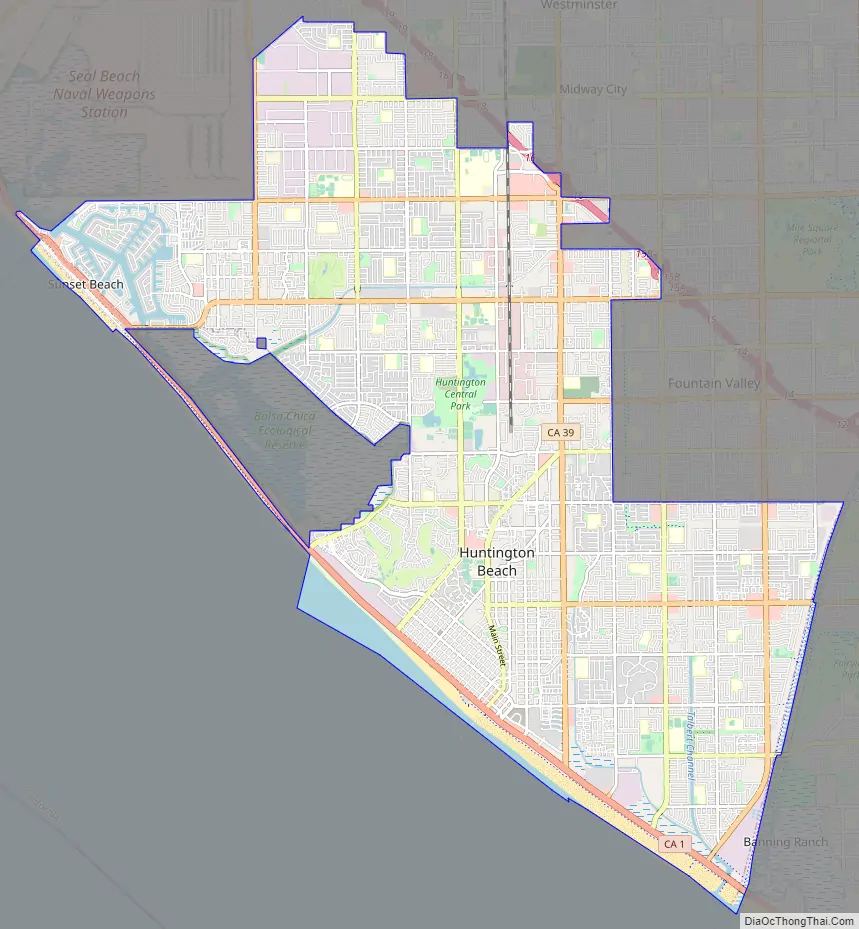
Huntington Beach Road Map
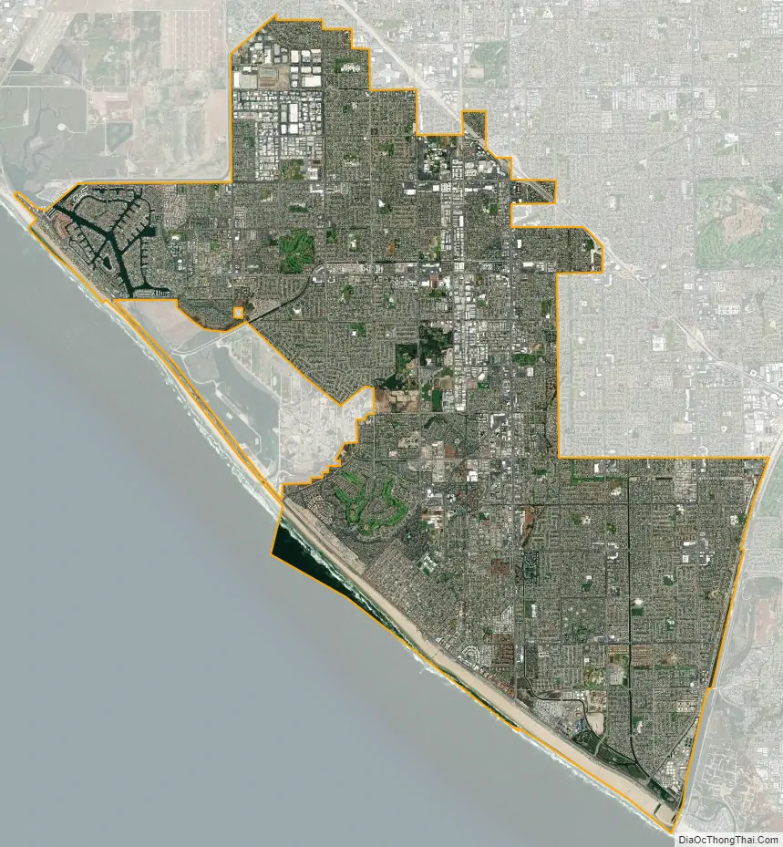
Huntington Beach city Satellite Map
Geography
According to the United States Census Bureau, the city has a total area of 31.9 square miles (82.6 km). 26.7 sq mi (69 km) of it is land and 5.1 sq mi (13 km) of it (16.10%) is water.
The entire city of Huntington Beach lies in area codes 714 and 657, except for small parts of Huntington Harbour (along with Sunset Beach, the community adjacent to Huntington Harbour), which is in the 562 area code.
Climate
Huntington Beach has a borderline semi-arid/Mediterranean climate (Köppen climate classification: BSk/Csb), gradually changing for the second to the west and south due to its low precipitation. Although areas such as Huntington Central Park and northern Bolsa Chica usually fall into the first climate type, thus being the boundary of the cool summer Mediterranean climate on the west coast of North America, except for elevated portions in the southern end of the state. The climate is generally sunny, dry and cool, although evenings can be excessively damp. In the morning and evening, there are often strong breezes that can reach 15 mph (24 km/h). Ocean water temperatures average 55 to 65 °F (13 to 18 °C). In the summer, temperatures rarely exceed 85 °F (29 °C). In the winter, temperatures rarely fall below 40 °F (4 °C), even on clear nights. There are about 14 inches (360 mm) of rain, almost all in mid-winter. Frost occurs only rarely, on the coldest winter nights. The area is annually affected by a marine layer caused by the cool air of the Pacific Ocean meeting the warm air over the land. This results in overcast and foggy conditions in May and June.
Natural resources
Construction of any kind on the beach is prohibited without a vote by current homeowners.
Between Downtown Huntington Beach and Huntington Harbour lies a large marshy wetland, much of which is protected within the Bolsa Chica Ecological Reserve. A $110 million restoration of the wetlands was completed in 2006. The reserve is popular with bird watchers and photographers.
South of Downtown, the Talbert, Brookhurst and Magnolia Marshes, which lie across the street from Huntington State Beach, had restoration completed in 2010.
The northern and southern beaches (Bolsa Chica State Beach and Huntington State Beach, respectively) are state parks. Only the central beach (Huntington City Beach) is maintained by the city. Camping and RVs are permitted here, and popular campsites for the Fourth of July and the Surfing Championships must be reserved many months in advance. Bolsa Chica State Beach is actually a sand bar fronting the Bolsa Bay and Bolsa Chica State Ecological Reserve.
The Orange County run Sunset Marina Park next to Huntington Harbour is part of Anaheim Bay. It is suitable for light craft, and includes a marina, launching ramp, basic services, a picnic area and a few restaurants. The park is in Seal Beach, but is only reachable from Huntington Harbour. The Sunset/Huntington Harbour area is patrolled by the Orange County Sheriff’s Harbor Patrol.
The harbor entrance for Anaheim Bay is sometimes restricted by the United States Navy, which loads ships with munitions at the Seal Beach Naval Weapons Station to the north of the main channel.
See also
Map of California State and its subdivision:- Alameda
- Alpine
- Amador
- Butte
- Calaveras
- Colusa
- Contra Costa
- Del Norte
- El Dorado
- Fresno
- Glenn
- Humboldt
- Imperial
- Inyo
- Kern
- Kings
- Lake
- Lassen
- Los Angeles
- Madera
- Marin
- Mariposa
- Mendocino
- Merced
- Modoc
- Mono
- Monterey
- Napa
- Nevada
- Orange
- Placer
- Plumas
- Riverside
- Sacramento
- San Benito
- San Bernardino
- San Diego
- San Francisco
- San Joaquin
- San Luis Obispo
- San Mateo
- Santa Barbara
- Santa Clara
- Santa Cruz
- Shasta
- Sierra
- Siskiyou
- Solano
- Sonoma
- Stanislaus
- Sutter
- Tehama
- Trinity
- Tulare
- Tuolumne
- Ventura
- Yolo
- Yuba
- Alabama
- Alaska
- Arizona
- Arkansas
- California
- Colorado
- Connecticut
- Delaware
- District of Columbia
- Florida
- Georgia
- Hawaii
- Idaho
- Illinois
- Indiana
- Iowa
- Kansas
- Kentucky
- Louisiana
- Maine
- Maryland
- Massachusetts
- Michigan
- Minnesota
- Mississippi
- Missouri
- Montana
- Nebraska
- Nevada
- New Hampshire
- New Jersey
- New Mexico
- New York
- North Carolina
- North Dakota
- Ohio
- Oklahoma
- Oregon
- Pennsylvania
- Rhode Island
- South Carolina
- South Dakota
- Tennessee
- Texas
- Utah
- Vermont
- Virginia
- Washington
- West Virginia
- Wisconsin
- Wyoming


