Map of Mexico Beach city

Map of Mexico Beach city

Mexico Beach is a city in Bay County, Florida, United States. It is located 25 miles (40 km) southeast of Panama City. The population was 1,060 at the 2020 census. The community was extensively damaged by Hurricane Michael on October 10, 2018. The Federal Emergency Management Agency (FEMA) declared the community “wiped out” in the aftermath … Read more

Map of Merritt Island CDP

Map of Merritt Island CDP

Merritt Island is an island, in Brevard County, Florida, United States, located on the eastern Floridian coast, along the Atlantic Ocean. It is also the name of an unincorporated town in the central and southern parts of the island and a census-designated place (CDP). The population was 34,518 at the 2020 census. It is part … Read more

Map of Miami Beach city

Map of Miami Beach city

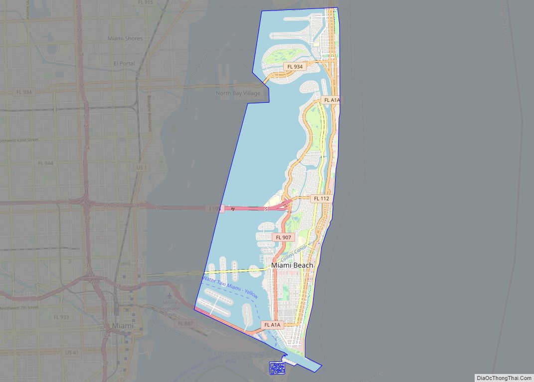
Miami Beach is a coastal resort city in Miami-Dade County, Florida, United States. The municipality is located on natural and human-made barrier islands between the Atlantic Ocean and Biscayne Bay, the latter of which separates the Beach from the mainland city of Miami. The neighborhood of South Beach, comprising the southernmost 2.5 sq mi (6.5 km) of Miami … Read more

Map of Miami Springs city

Map of Miami Springs city

Miami Springs is a city in Miami-Dade County, Florida, United States. The city was founded by Glenn Hammond Curtiss, “The Father of Naval Aviation”, and James Bright, during the famous “land boom” of the 1920s and was originally named “Country Club Estates”. It, along with other cities in Miami-Dade County such as Coral Gables and … Read more

Map of Miami Shores village

Map of Miami Shores village

Miami Shores or Miami Shores Village is a village in Miami-Dade County, Florida. As of the 2020 census, the population was 11,567, up from 10,493 in 2010. Miami Shores village overview: Name: Miami Shores village LSAD Code: 47 LSAD Description: village (suffix) State: Florida County: Miami-Dade County Incorporated: January 2, 1932 Elevation: 7 ft (2 m) Total … Read more

Map of Miami Lakes town

Map of Miami Lakes town

Miami Lakes is an incorporated town in Miami-Dade County, Florida, United States. As of the 2020 census, the population was 30,467. Miami Lakes town overview: Name: Miami Lakes town LSAD Code: 43 LSAD Description: town (suffix) State: Florida County: Miami-Dade County Incorporated: December 5, 2000 Elevation: 3 ft (1 m) Total Area: 6.51 sq mi (16.85 km²) Land Area: 5.66 sq mi … Read more

Map of Middleburg CDP

Map of Middleburg CDP, Florida

Middleburg is an unincorporated area and census-designated place (CDP) within Clay County in the U.S. state of Florida, located 26 miles (42 km) southwest of downtown Jacksonville and 16 miles (26 km) northwest of Green Cove Springs, the county seat of Clay County. As of the 2020 census,the population of Middleburg was 12,881. It is home to … Read more

Map of Micco CDP

Map of Micco CDP

Micco is a census-designated place (CDP) in Brevard County, Florida. The population was 9,052 at the 2010 United States Census. It is part of the Palm Bay–Melbourne–Titusville Metropolitan Statistical Area. Micco CDP overview: Name: Micco CDP LSAD Code: 57 LSAD Description: CDP (suffix) State: Florida County: Brevard County Elevation: 23 ft (7 m) Total Area: 9.85 sq mi (25.52 km²) … Read more

Map of Micanopy town

Map of Micanopy town

Micanopy (/ˌmɪkəˈnoʊpi/ (listen) MIK-ə-NOH-pee) is a town in Alachua County, Florida, United States, located south of Gainesville. The population as of the 2010 census was 600. The oldest community in the interior of Florida that has been continually inhabited, it has a downtown that is designated as the Micanopy Historic District and listed on the … Read more

Map of Mims CDP

Map of Mims CDP

Mims is a census-designated place (CDP) in Brevard County, Florida. The population was 7,058 at the 2010 United States Census. Mims CDP overview: Name: Mims CDP LSAD Code: 57 LSAD Description: CDP (suffix) State: Florida County: Brevard County Elevation: 33 ft (10 m) Total Area: 22.37 sq mi (57.93 km²) Land Area: 17.07 sq mi (44.21 km²) Water Area: 5.30 sq mi (13.72 km²) Total Population: … Read more

Map of Milton city, Florida

Map of Milton city, Florida

Milton is a city in and the county seat of Santa Rosa County, Florida. It is located within the Pensacola Metropolitan Statistical Area. Milton is located in the geographic center of Santa Rosa County, it is bordered by Pace to the west, and Navarre to the South. As of April 1, 2020, the population of … Read more

Map of Midway CDP, Florida

Map of Midway CDP, Florida

Midway is a census-designated place and an unincorporated area in Seminole County, Florida, United States. The population was 1,714 at the 2000 census. It is part of the Orlando–Kissimmee–Sanford Metropolitan Statistical Area. Midway CDP overview: Name: Midway CDP LSAD Code: 57 LSAD Description: CDP (suffix) State: Florida County: Seminole County Elevation: 26 ft (8 m) Total Area: … Read more