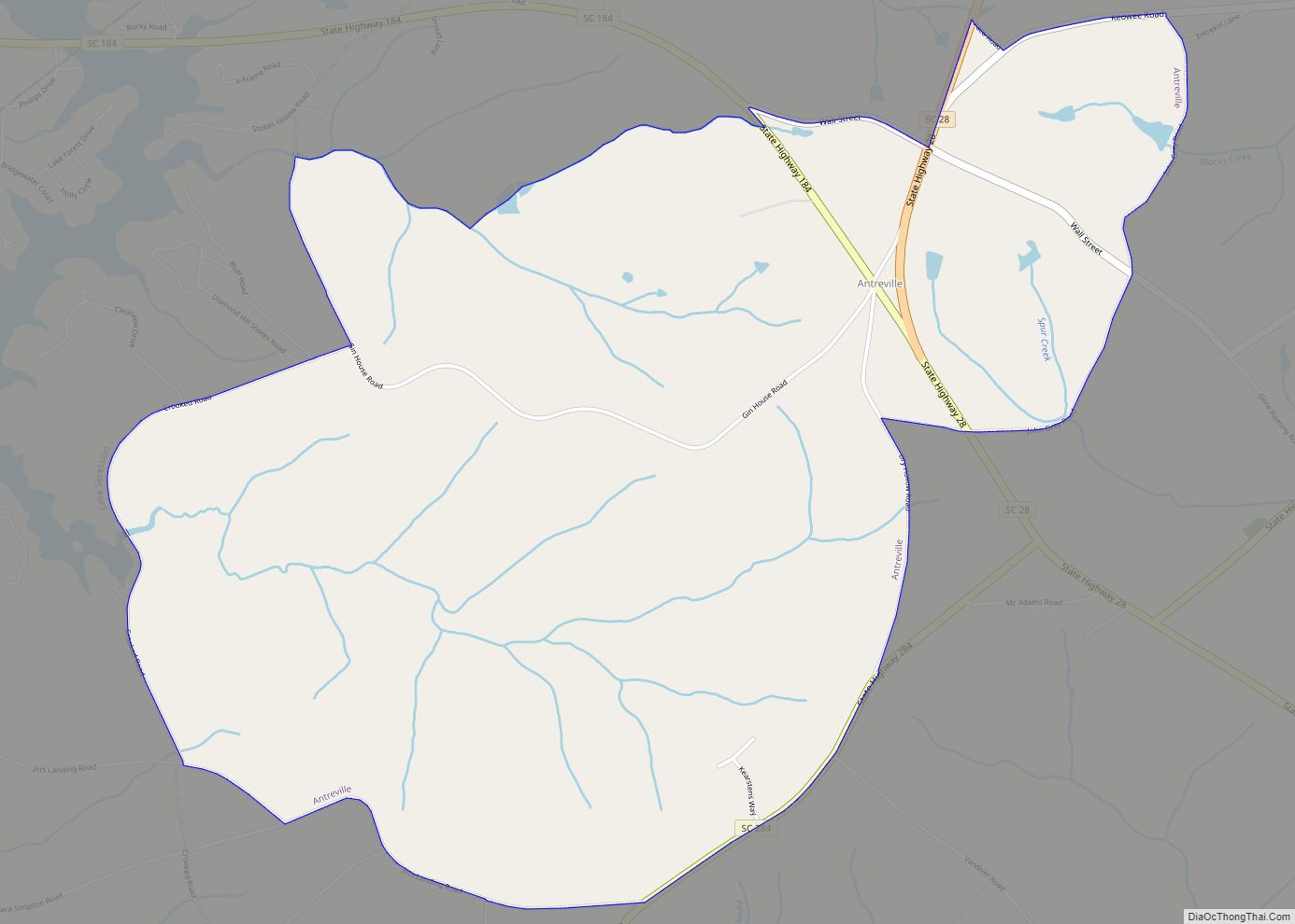
Map of Andrews town, South Carolina
Andrews is a town in both Georgetown and Williamsburg counties in the U.S. state of South Carolina. Its population was 2,861 at the 2010 census, down from 3,068 in 2000. General aviation airfield Robert F. Swinnie Airport is 2 miles (3 km) east of its central business district. Andrews town overview: Name: Andrews town LSAD Code: ... Read more
Map of Andrews town, South Carolina
Map of Anderson city, South Carolina
Anderson is a city in and the county seat of Anderson County, South Carolina, United States. The population was 28,106 at the 2020 census, and the city was the center of an urbanized area of 75,702. It is one of the principal cities in the Greenville-Anderson-Mauldin Metropolitan Statistical Area, which had a population of 824,112 ... Read more
Map of Anderson city, South Carolina
Map of Allendale town, South Carolina
Allendale is a town in and the county seat of Allendale County, South Carolina, United States. The population was 3,482 at the 2010 census, a decline from 4,052 in 2000. Allendale town overview: Name: Allendale town LSAD Code: 43 LSAD Description: town (suffix) State: South Carolina County: Allendale County Elevation: 187 ft (57 m) Total Area: 3.31 sq mi ... Read more
Map of Allendale town, South Carolina
Map of Belvedere CDP, South Carolina
Belvedere is a census-designated place (CDP) and suburb of North Augusta in Aiken County, South Carolina, United States. It is part of the Augusta, Georgia metropolitan area. The population was 5,792 at the 2010 census. Belvedere (from Italian, meaning “beautiful sight”) was so named for its scenic river views over the Savannah River. Belvedere CDP ... Read more
Map of Belvedere CDP, South Carolina
Map of Belton city, South Carolina
Belton is a city in eastern Anderson County, South Carolina, United States. The population was 4,134 at the 2010 census. Belton city overview: Name: Belton city LSAD Code: 25 LSAD Description: city (suffix) State: South Carolina County: Anderson County Elevation: 883 ft (269 m) Total Area: 3.79 sq mi (9.80 km²) Land Area: 3.78 sq mi (9.79 km²) Water Area: 0.01 sq mi (0.02 km²) Total ... Read more
Map of Belton city, South Carolina
Map of Beaufort city, South Carolina
Beaufort (/ˈbjuːfərt/ BEW-fert, different from that of Beaufort, North Carolina) is a city in and the county seat of Beaufort County, South Carolina, United States. Chartered in 1711, it is the second-oldest city in South Carolina, behind Charleston. A city rich in history, culture, southern hospitality, and a seaside charm, Beaufort is affectionally known as ... Read more
Map of Beaufort city, South Carolina
Map of Batesburg-Leesville town
Batesburg-Leesville is a town located in Lexington and Saluda counties, South Carolina, United States. The town’s population was 5,362 as of the 2010 census and an estimated 5,415 in 2019. Batesburg-Leesville town overview: Name: Batesburg-Leesville town LSAD Code: 43 LSAD Description: town (suffix) State: South Carolina County: Lexington County, Saluda County Elevation: 643 ft (196 m) Total ... Read more
Map of Batesburg-Leesville town
Map of Barnwell city
Barnwell is a city in and county seat of Barnwell County, South Carolina, United States, located along U.S. Route 278. The population was 4,750 at the 2010 census. Barnwell city overview: Name: Barnwell city LSAD Code: 25 LSAD Description: city (suffix) State: South Carolina County: Barnwell County Elevation: 217 ft (66 m) Total Area: 7.99 sq mi (20.70 km²) Land ... Read more
Map of Barnwell city
Map of Bamberg town
Bamberg is a city in and the county seat of Bamberg County, South Carolina, United States. The population was 3,607 at the 2010 census. Bamberg town overview: Name: Bamberg town LSAD Code: 43 LSAD Description: town (suffix) State: South Carolina County: Bamberg County Elevation: 164 ft (50 m) Total Area: 3.60 sq mi (9.31 km²) Land Area: 3.58 sq mi (9.26 km²) Water ... Read more
Map of Bamberg town
Map of Aynor town
Aynor is a small town in Horry County, South Carolina, United States, south of Galivants Ferry. The population was 560 at the 2010 census and estimated in 2018 to be 934. Aynor High School consistently ranks as one of the best schools in Horry County and South Carolina. Aynor town overview: Name: Aynor town LSAD ... Read more
Map of Aynor town
Map of Awendaw town
Awendaw is a small fishing town in Charleston County, South Carolina, United States. The population was 1,294 at the 2010 census. Awendaw is part of the Charleston, South Carolina metropolitan area. Awendaw town overview: Name: Awendaw town LSAD Code: 43 LSAD Description: town (suffix) State: South Carolina County: Charleston County Elevation: 20 ft (6 m) Total Area: ... Read more
Map of Awendaw town
Map of Atlantic Beach town, South Carolina
Atlantic Beach is a town in Horry County, South Carolina, United States, part of the Grand Strand tourist region. The population was 334 at the 2010 census. Most of the land around the town is annexed into the city of North Myrtle Beach. Atlantic Beach town overview: Name: Atlantic Beach town LSAD Code: 43 LSAD ... Read more
Map of Atlantic Beach town, South Carolina