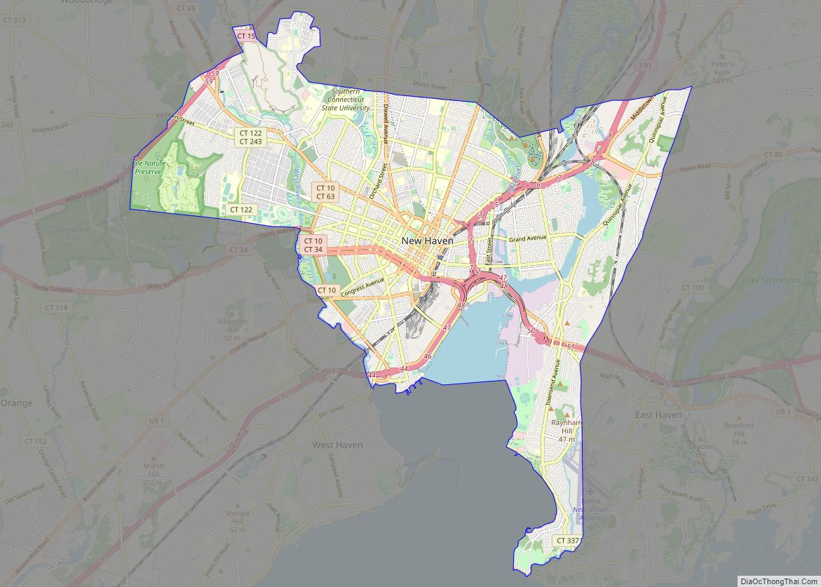
Map of Carrollton city, Texas

Map of Carrollton city, Texas

Carrollton is a city in Dallas, Denton, and Collin counties in the U.S. state of Texas. As of the 2020 census, its population was 133,434, making it the 23rd-most populous city in Texas. Carrollton city overview: Name: Carrollton city LSAD Code: 25 LSAD Description: city (suffix) State: Texas County: Collin County, Dallas County, Denton County … Read more

Map of Kent city, Washington

Map of Kent city, Washington

Kent is a city in King County, Washington, United States. It is part of the Seattle–Tacoma–Bellevue metropolitan area and had a population of 136,588 as of the 2020 census, making it the fourth-largest municipality in greater Seattle and the sixth-largest in Washington state. The city is connected to Seattle, Bellevue and Tacoma via State Route … Read more

Map of Norman city, Oklahoma

Map of Norman city, Oklahoma

Norman (/ˈnɔːrmən/) is the third-largest city in the U.S. state of Oklahoma, with a population of 128,097 as of 2021. It is the largest city and the county seat of Cleveland County, and the second-largest city in the Oklahoma City metropolitan area, behind the state capital, Oklahoma City. It is 20 miles (32 kilometers) south … Read more

Map of Midland city, Texas

Map of Midland city, Texas

Midland is a city in and the county seat of Midland County, Texas, United States. A small part of Midland is in Martin County. At the 2020 census, Midland’s population was 132,524. It is the principal city of the Midland, Texas metropolitan statistical area, which includes all of Midland County, the population of which was … Read more

Map of Coral Springs city

Map of Coral Springs city

Coral Springs, officially the City of Coral Springs, is a city in Broward County, Florida, United States. The city is located approximately 20 miles (32 km) northwest of Fort Lauderdale. As of the 2020 U.S. Census, the city had a population of 134,394. It is a principal city of the Miami metropolitan area, which was home … Read more

Map of Columbia city, Missouri

Map of Columbia city, Missouri

Columbia /kəˈlʌmbiə/ is a city in the U.S. state of Missouri. It is the county seat of Boone County and home to the University of Missouri. Founded in 1821, it is the principal city of the five-county Columbia metropolitan area. It is Missouri’s fourth most-populous and fastest growing city, with an estimated 128,555 residents in … Read more

Map of Topeka city, Kansas

Map of Topeka city, Kansas

Topeka (/təˈpiːkə/ tə-PEE-kə; Kansa: tó ppí kʼé; Iowa-Oto: Dópikˀe or Dópiúkˀe) is the capital city of the U.S. state of Kansas and the seat of Shawnee County. It is along the Kansas River in the central part of Shawnee County, in northeast Kansas, in the Central United States. As of the 2020 census, the population … Read more