Coral Springs, officially the City of Coral Springs, is a city in Broward County, Florida, United States. The city is located approximately 20 miles (32 km) northwest of Fort Lauderdale. As of the 2020 U.S. Census, the city had a population of 134,394. It is a principal city of the Miami metropolitan area, which was home to an estimated 6,012,331 people at the 2015 census.
The city, officially chartered on July 10, 1963, was master-planned and primarily developed by Coral Ridge Properties, Inc., which was acquired by Westinghouse in 1966. The city’s name is derived from the company’s name, and was selected after several earlier proposals had been considered and rejected. Despite the name, there are no natural springs in the city; Florida’s springs are found in the central and northern portions of the state.
During the 1970s, 1980s, and 1990s the young city grew rapidly, adding over 35,000 residents each decade. Coral Springs has notably strict building codes, which are designed to maintain the city’s distinctive aesthetic appeal. The city government’s effective fiscal management has maintained high bond ratings, and the city has won accolades for its overall livability, its low crime rate, and its family-friendly orientation.
| Name: | Coral Springs city |
|---|---|
| LSAD Code: | 25 |
| LSAD Description: | city (suffix) |
| State: | Florida |
| County: | Broward County |
| Incorporated: | July 10, 1963 |
| Elevation: | 13 ft (3 m) |
| Total Area: | 23.99 sq mi (62.13 km²) |
| Land Area: | 22.86 sq mi (59.22 km²) |
| Water Area: | 1.12 sq mi (2.91 km²) |
| Total Population: | 134,394 |
| Population Density: | 5,877.97/sq mi (2,269.45/km²) |
| Area code: | 754 and 954 |
| FIPS code: | 1214400 |
| GNISfeature ID: | 0307614 |
| Website: | www.CoralSprings.org |
Online Interactive Map
Click on ![]() to view map in "full screen" mode.
to view map in "full screen" mode.
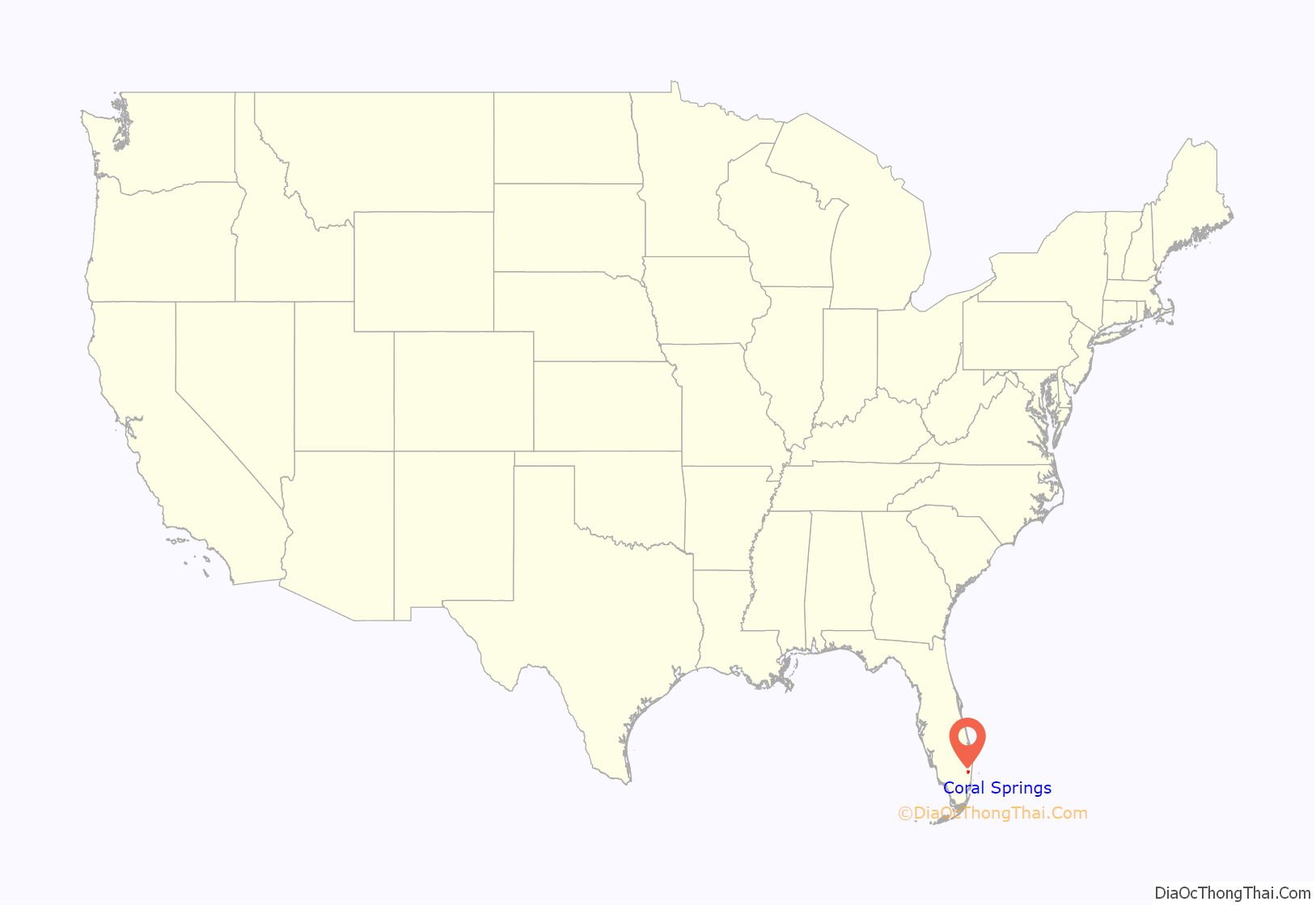
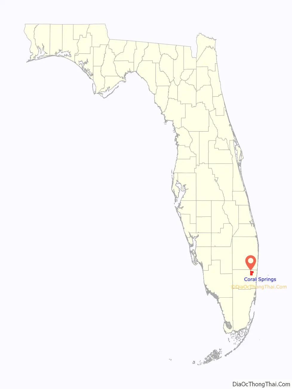
Coral Springs location map. Where is Coral Springs city?
History
Coral Springs is a planned community. Prior to its incorporation as a city in July 1963, the area which is now Coral Springs was part of 20,000 acres (81 km) of marshy lands bought by Henry Lyons between 1911 and 1939. After several floods in 1947, Florida created the Central and Southern Florida Flood Control District (now the South Florida Water Management District). Canals and levees drained much of the area upon which Coral Springs was built. After the land was drained and cleared, most of the area was used as a bean farm. After Lyons’ death in 1952, his heirs changed the focus to cattle.
A post-World War II real estate boom in South Florida attracted the interest of developers. Coral Ridge Properties, which already had several developments in Broward County, bought 3,869 acres (16 km) of land from the Lyons family on December 14, 1961, for $1 million. The City of Coral Springs was chartered on July 10, 1963. Other names that were considered for the new city included “Curran Village,” “Pompano Springs” and “Quartermore”. By 1964, the company had developed a master plan for a city of 50,000 residents. On July 22, 1964, the first sale of 536 building lots netted $1.6 million. The landmark covered bridge was built that same year to promote the town. In 1965, Coral Ridge Properties bought an additional 6,000 acres (24 km) from the Lyons family, increasing the city’s land area to 16 square miles (41 km). The first city government elections were held in 1967.
The city added 19 public schools, a regional mall, shopping centers and parks between 1970 and 2000 in response to rapid population growth. The biggest shopping mall in the city is Coral Square, which opened in October 1984 with 945,000 square feet (87,800 m) of retail space and more than 120 stores. The construction of the Sawgrass Expressway in 1986 brought even more growth. A museum and a theater opened in the 1990s. The city reached residential build-out in 2003 and is very close to a commercial build-out.
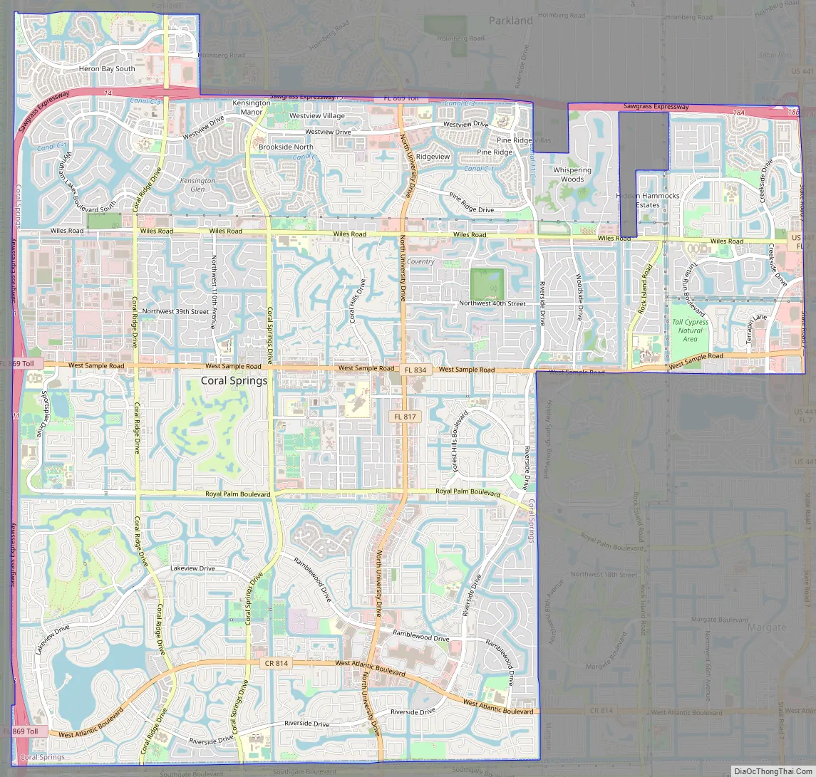
Coral Springs Road Map
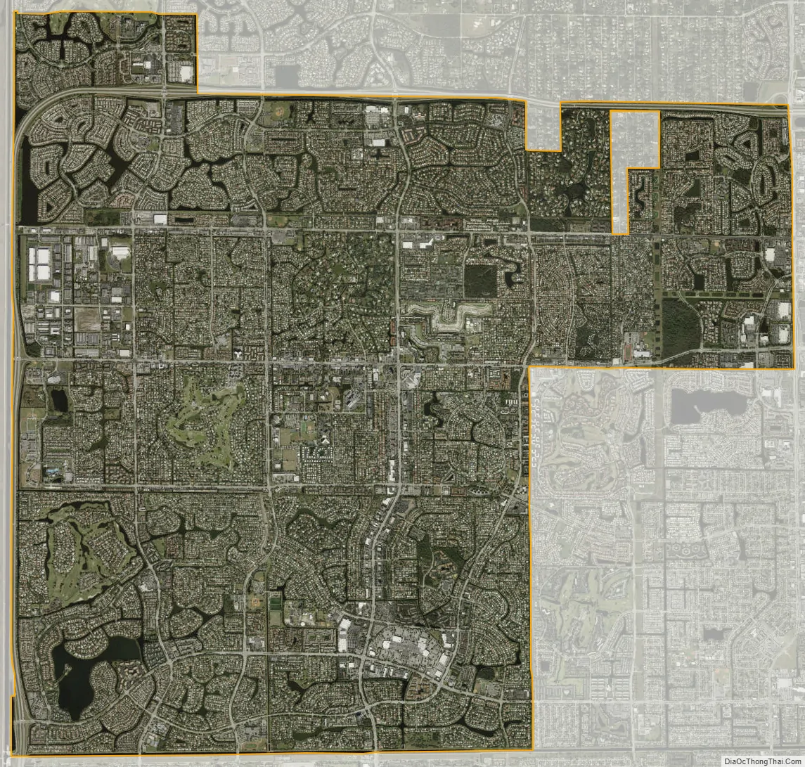
Coral Springs city Satellite Map
Geography
According to the U.S. Census Bureau, the city has a total area of 24.0 square miles (62.1 km), 23.8 square miles (61.6 km) of which is land and 0.19 square miles (0.5 km) of which is water (0.83%). Coral Springs is bordered by the cities of Parkland to the north, Coconut Creek to the east, Margate and North Lauderdale to the southeast and Tamarac to the south. To the west lie The Everglades.
Cityscape
Coral Springs is a sprawling city, with few tall or prominent structures. The tallest building in the city is a 12-story condominium (Country Club Tower), with five more buildings topping out at or near 10 stories, including four office buildings lining University Drive, one of the city’s main roads. Buildings include the University Place at City Center, Coral Springs Executive Tower, Bank of America Center, and the Briarwood Towers. The Coral Springs Financial Plaza was the first major office building in the city; built in 1974 as the Bank of Coral Springs Building, it had 10 floors and 123,469 sq ft of office space; it was demolished in 2021. University Place at City Center, at 3111 N. University Drive, is the largest office building in the city in terms of office space—it has 10 floors and 203,000 sq ft (18,900 m). It opened as the Preferred Exchange Tower in 1985.
Coral Ridge Properties established strict landscaping and sign laws for the city—a question in the original version of Trivial Pursuit noted that the city hosted the first McDonald’s without the distinctive Golden Arches sign. Restrictions on commercial signs, exterior paint colors, roofing materials, recreational vehicle and boat storage, and landscaping specifications are all strictly enforced; consequently, real estate values in the city are significantly higher than the county as a whole. In 2006, the median price of a single family home in Coral Springs was US$415,000, while the median price county-wide was US$323,000.
The city’s downtown at the intersection of Sample Road and University Drive is the focus of an extensive redevelopment plan, estimated to cost close to US$700 million. The plan to revitalize the city’s core started with an open-air shopping and entertainment center—”The Walk”—and progressed with the construction of “One Charter Place,” opened April 2007. When completed, the redeveloped downtown area will offer office, retail, and a new government center, encompassing approximately three million square feet of floor space, in addition to approximately 1,000 residential units and a new hotel. The city’s new $38 million city hall complex opened in January 2018, replacing the old building which was demolished later that year. The current downtown project in development, “Cornerstone Downtown Coral Springs”, will feature two residential towers, a hotel, and a shopping, office and entertainment complex. The project began construction in 2022, following the demolition of the Coral Springs Financial Plaza at the end of 2021.
The City of Coral Springs’ Parks and Recreation Department operates over 50 municipal parks, including a water park and a skate park, encompassing over 675 acres (2.7 km). Coral Springs’ largest park is Mullins Park (70 acres). Of the four natural conservation areas in the city, Sandy Ridge Sanctuary is the biggest, at 38 acres (150,000 m).
Climate
Coral Springs experiences a tropical rainforest climate (Köppen climate classification: Af). Average monthly rainfall is higher from April to September, with January and February as the driest months. The average monthly rainfall ranges from 2.8 inches (7 cm) in January and February to 7.3 inches (19 cm) in June. The hurricane season is from June to November, with September as the month during which hurricanes are most likely to occur. The most powerful hurricane to strike Coral Springs since its incorporation was Wilma in 2005; the eye of the hurricane passed directly over the city. The city estimated that “as a result of the numerous hurricanes and storms that hit Coral Springs in 2004/2005, and especially as a result of Hurricane Wilma, the tree canopy coverage throughout the city has been reduced by about one third”. A 2017 study put Coral Springs in fourth place for US cities most vulnerable to coastal flooding, with 115,000 residents living within FEMA’s coastal floodplain.
See also
Map of Florida State and its subdivision:- Alachua
- Baker
- Bay
- Bradford
- Brevard
- Broward
- Calhoun
- Charlotte
- Citrus
- Clay
- Collier
- Columbia
- Desoto
- Dixie
- Duval
- Escambia
- Flagler
- Franklin
- Gadsden
- Gilchrist
- Glades
- Gulf
- Hamilton
- Hardee
- Hendry
- Hernando
- Highlands
- Hillsborough
- Holmes
- Indian River
- Jackson
- Jefferson
- Lafayette
- Lake
- Lee
- Leon
- Levy
- Liberty
- Madison
- Manatee
- Marion
- Martin
- Miami-Dade
- Monroe
- Nassau
- Okaloosa
- Okeechobee
- Orange
- Osceola
- Palm Beach
- Pasco
- Pinellas
- Polk
- Putnam
- Saint Johns
- Saint Lucie
- Santa Rosa
- Sarasota
- Seminole
- Sumter
- Suwannee
- Taylor
- Union
- Volusia
- Wakulla
- Walton
- Washington
- Alabama
- Alaska
- Arizona
- Arkansas
- California
- Colorado
- Connecticut
- Delaware
- District of Columbia
- Florida
- Georgia
- Hawaii
- Idaho
- Illinois
- Indiana
- Iowa
- Kansas
- Kentucky
- Louisiana
- Maine
- Maryland
- Massachusetts
- Michigan
- Minnesota
- Mississippi
- Missouri
- Montana
- Nebraska
- Nevada
- New Hampshire
- New Jersey
- New Mexico
- New York
- North Carolina
- North Dakota
- Ohio
- Oklahoma
- Oregon
- Pennsylvania
- Rhode Island
- South Carolina
- South Dakota
- Tennessee
- Texas
- Utah
- Vermont
- Virginia
- Washington
- West Virginia
- Wisconsin
- Wyoming


