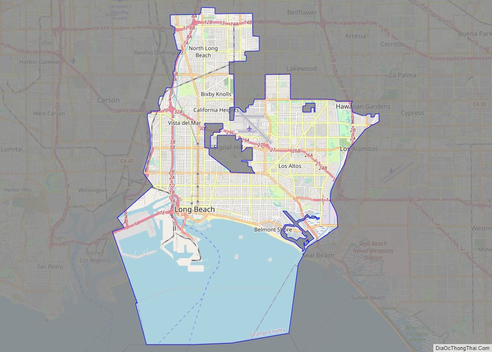
Map of Colorado Springs city

Map of Colorado Springs city

Colorado Springs, coloquially called The Springs, is a home rule municipality in and the county seat of El Paso County, Colorado, United States. It is the largest city in El Paso County, with a population of 478,961 at the 2020 United States Census, a 15.02% increase since 2010. Colorado Springs is the second-most populous city … Read more

Map of Miami city, Florida

Map of Miami city, Florida

Miami (/maɪˈæmi/ my-AM-ee), officially the City of Miami, is a coastal metropolis and the seat of Miami-Dade County in South Florida. With a population of 442,241 as of the 2020 census, it is the second-most populous city in the state of Florida after Jacksonville. It is the core of the much larger Miami metropolitan area, … Read more

Map of Minneapolis city, Minnesota

Map of Minneapolis city, Minnesota

Minneapolis (/ˌmɪniˈæpəlɪs/ (listen) MIN-ee-AP-əl-iss), officially the City of Minneapolis, is a city in the state of Minnesota and the county seat of Hennepin County. As of the 2020 census the population was 429,954, making it the largest city in Minnesota and the 46th-most-populous in the United States. Nicknamed the “City of Lakes”, Minneapolis is abundant … Read more

Map of Wichita city

Map of Wichita city

Wichita (/ˈwɪtʃɪtɑː/ WITCH-i-tah) is the largest city in the U.S. state of Kansas and the county seat of Sedgwick County. As of the 2020 census, the population of the city was 397,532. The Wichita metro area had a population of 647,610 in 2020. It is located in south-central Kansas on the Arkansas River. Wichita began … Read more

Map of Tulsa city

Map of Tulsa city

Tulsa (/ˈtʌlsə/) is the second-largest city in the state of Oklahoma and 47th-most populous city in the United States. The population was 413,066 as of the 2020 census. It is the principal municipality of the Tulsa metropolitan area, a region with 1,023,988 residents. The city serves as the county seat of Tulsa County, the most … Read more

Map of Tampa city

Map of Tampa city, Florida

Tampa city overview: Name: Tampa city LSAD Code: 25 LSAD Description: city (suffix) State: Florida County: Hillsborough County Elevation: 48 ft (14.6 m) Land Area: 114.02 sq mi (295.30 km²) Water Area: 61.82 sq mi (160.10 km²)  35.3% Population Density: 3,376.4/sq mi (1,303.6/km²) ZIP code: 33601–33626, 33629–33631, 33633–33635, 33637, 33646, 33647, 33650, 33655, 33660–33664, 33672–33675, 33677, 33679–33682, 33684–33689, 33694 Area code: 813, 656 FIPS … Read more

Map of Aurora city

Map of Aurora city, Colorado

Aurora (/əˈroʊrə/, /əˈrɔːrə/) is a home rule municipality located in Arapahoe, Adams, and Douglas counties, Colorado, United States. The city’s population was 386,261 at the 2020 United States Census with 336,035 residing in Arapahoe County, 47,720 residing in Adams County, and 2,506 residing in Douglas County. Aurora is the third most populous city in the … Read more

Map of Arlington city, Texas

Map of Arlington city, Texas

Arlington is a city in the U.S. state of Texas, located in Tarrant County. It forms part of the Mid-Cities region of the Dallas–Fort Worth–Arlington metropolitan statistical area, and is a principal city of the metropolis and region. The city had a population of 394,266 in 2020, making it the second-largest city in the county, after … Read more

Map of Urban Honolulu CDP

Map of Urban Honolulu CDP

Urban Honolulu CDP overview: Name: Urban Honolulu CDP LSAD Code: 57 LSAD Description: CDP (suffix) State: Hawaii County: Honolulu County FIPS code: 1571550 Explore the streets of Honolulu with this interactive Google Map of Honolulu. Take a journey to the state capital and discover the many attractions and special places that make this a great … Read more