| Name: | Tampa city |
|---|---|
| LSAD Code: | 25 |
| LSAD Description: | city (suffix) |
| State: | Florida |
| County: | Hillsborough County |
| Elevation: | 48 ft (14.6 m) |
| Land Area: | 114.02 sq mi (295.30 km²) |
| Water Area: | 61.82 sq mi (160.10 km²) 35.3% |
| Population Density: | 3,376.4/sq mi (1,303.6/km²) |
| ZIP code: | 33601–33626, 33629–33631, 33633–33635, 33637, 33646, 33647, 33650, 33655, 33660–33664, 33672–33675, 33677, 33679–33682, 33684–33689, 33694 |
| Area code: | 813, 656 |
| FIPS code: | 1271000 |
| GNISfeature ID: | 0292005 |
| Website: | www.tampa.gov |
Download our Tampa map collection to help you navigate around the city and find things to do. It features major highways, roads, and places to visit. But first, get to know Tampa with our interactive map.
Tampa, Florida is located in west Florida along the Gulf Coast. The city is situated along the shallow estuary known as Tampa Bay. The Hillsborough River meanders through Tampa originating from the Green Swamp area.
Centered around Ybor City, the city’s historic district, Tampa is now a hub for art, culture, and nightlife. There are many things to see and do in Tampa, and the city is a great base from which to explore the rest of the panhandle and the rest of Florida.
If you’re looking to explore Tampa, our map collection is here to help. Download it now and discover all the exciting places the city has to offer!
Online Interactive Map
Click on ![]() to view map in "full screen" mode.
to view map in "full screen" mode.
The map is designed to be interactive, letting you search for the businesses that are important to you and find them on the map. You can also see what’s nearby, find driving directions, or even compare different routes. This map is an interactive way to explore Tampa Florida. Users can toggle between road and aerial views, zoom in and out, and search for points of interest. Find the best places to visit in Florida like the newest restaurants, hotels, and shops in Tampa with this map.
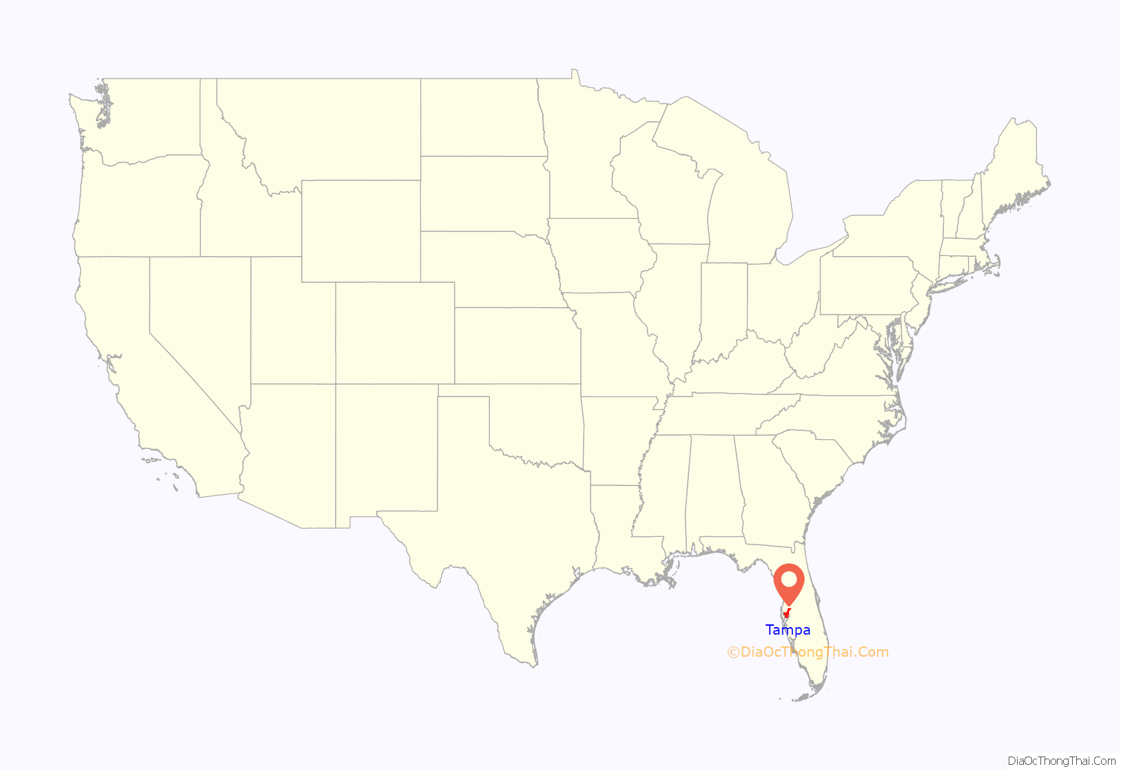
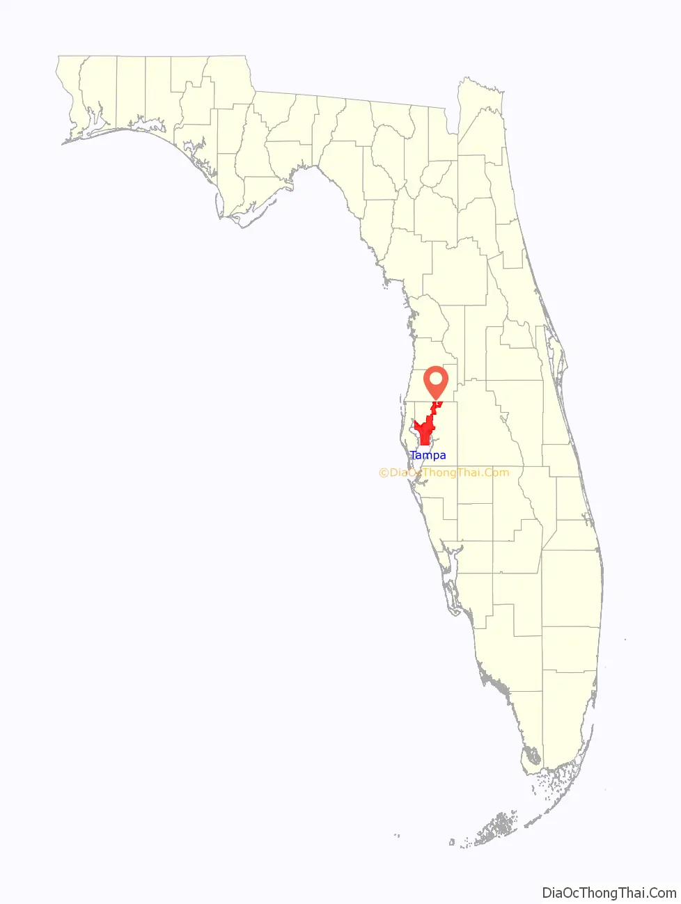
Tampa location map. Where is Tampa city?
History
Indigenous peoples and European exploration
The shores of Tampa Bay have been inhabited for thousands of years. A variant of the Weeden Island culture developed in the area by about 2000 years ago, with archeological evidence suggesting that these residents relied on the sea for most of their resources, as a vast majority of inhabited sites have been found on or near the shoreline and there is little evidence of farming. At the time of European contact in the early 16th century, several chiefdoms of the Safety Harbor culture dominated the area.
Early Spanish explorers interacted most extensively with the Tocobaga, whose principal town was at the northern end of Old Tampa Bay near today’s Safety Harbor in Pinellas County. While there is a substantial historical record of the Tocobaga (and the Calusa, who lived to the south), there is less surviving documentation describing the Pohoy, who lived near the mouth of the Hillsborough River near today’s downtown Tampa. However, evidence suggests that the language and culture of the Pohoy and other lesser-known groups around the bay were very similar to that of the Tocobaga.
Expeditions led by Pánfilo de Narváez and Hernando de Soto landed near Tampa, but neither conquistador stayed long. There is no natural gold or silver in Florida, and the native inhabitants repulsed Spanish attempts to establish a permanent settlement or convert them to Catholicism. The fighting resulted in a few deaths, but the many more deaths were caused by infectious diseases brought from Europe, which devastated the population of Native Americans across Florida and the entire Western Hemisphere. The indigenous cultures of the Tampa Bay area had collapsed by around 1600, leaving the west coast of Spanish Florida largely depopulated and ignored for more than 200 years.
In the mid-18th century, events in the American colonies and the early United States drove the Seminole people into northern Florida, but they did not move into central Florida until after the United States gained control of Florida in 1821.
Before the American period, the Tampa Bay area had a handful of residents: Cuban and Native American fishermen who established small seasonal camps called “ranchos” on the shores of Tampa Bay. The largest was at the mouth of Spanishtown Creek in today’s Hyde Park neighborhood along Bayshore Boulevard.
U.S. control
After purchasing Florida from Spain in 1821, the United States built forts and trading posts in the new territory. Fort Brooke was established in January 1824 at the mouth of the Hillsborough River on Tampa Bay, in Downtown Tampa.
Tampa was initially an isolated frontier outpost. The sparse civilian population practically abandoned the area during the Second Seminole War from 1835 to 1842, after which the Seminoles were forced out and many settlers returned.
Florida became the 27th state on March 3, 1845. On January 18, 1849, Tampa was officially incorporated as the “Village of Tampa.” It was home to 185 civilians, or 974 total residents including military personnel, in 1850. Tampa was reincorporated as a town on December 15, 1855.
Civil War and Reconstruction
During the Civil War, Florida seceded along with most of the southern states to form the Confederate States of America, and Fort Brooke was defended by Confederate troops. Martial law was declared in Tampa in January 1862, and Tampa’s city government ceased to operate for the duration of the war.
In 1861, the Union Navy set up a blockade around many southern ports to cut off the Confederacy. Several US Navy ships were stationed near the mouth of Tampa Bay, but small blockade running ships were often able to slip by the blockade to deliver cattle to Spanish Cuba, earning gold for the Confederate cause. On June 30, 1862, the gunboat USS Sagamore sailed into Tampa Bay and opened fire on Fort Brooke, which returned fire. The Sagamore withdrew after a few hours, and the Battle of Tampa caused little damage. During the Battle of Fort Brooke on October 16 and the Battle of Ballast Point on October 18, 1863, Union forces inflicted serious damage to the city’s economy when, under the cover of another bombardment of the fort, troops landed and destroyed two blockade running ships that had been hidden upstream along the Hillsborough River.
In May 1864, Union troops landed again and took Fort Brooke largely unopposed. They destroyed much of the fort’s facilities and confiscated the remaining military supplies other than the canons, which they tossed into the Hillsborough River, then left the “desolate” town after two days.
The Civil War ended in April 1865 with a Confederate defeat. In May 1865, federal troops arrived in Tampa to occupy the fort and the town as part of Reconstruction. They remained until August 1869.
During the immediate post-war period, Tampa was a poor, isolated fishing village with about 1000 residents and little industry. Yellow fever, borne by mosquitoes from nearby swamps, broke out several times during the 1860s and 1870s, causing more residents to leave. In 1869, residents voted to abolish the city of Tampa government.
The population of “Tampa Town” was about 800 by 1870 and dropped to about 700 by 1880. Fort Brooke was decommissioned in 1883, further impacting the local economy in the short run but opening up the waterfront for development. Except for two cannons displayed on the University of Tampa campus, all traces of the fort are gone.
1880s economic prosperity
In the mid-1880s, Tampa’s fortunes took several sudden turns for the better. First, phosphate was discovered in the Bone Valley region southeast of Tampa in 1883. The mineral, vital for the production of fertilizers and other products, was soon being shipped from the Port of Tampa in great volume. Tampa is still a major phosphate exporter.
The discovery of phosphate, the arrival of Plant’s railroad, and the founding of Ybor City and West Tampa—all in the mid-1880s—were crucial to Tampa’s development. The once-struggling village of Tampa became a bustling boomtown almost overnight and had grown into one of the largest cities in Florida by 1900.
Henry B. Plant’s narrow-gauge South Florida Railroad reached Tampa and its port in late 1883, finally connecting the small town to the nation’s railroad system after years of efforts by local leaders. Previously, Tampa’s overland transportation links had consisted of sandy roads stretching across the Florida countryside. Plant’s railroad made it much easier to get goods in and out of the Tampa Bay area. Phosphate and commercial fishing exports could be sent north by rail, and many new products were brought into the Tampa market, along with the first tourists.
The new railroad link enabled another important industry to come to Tampa. In 1885, the Tampa Board of Trade enticed Vicente Martinez Ybor to move his cigar manufacturing operations to Tampa from Key West. Proximity to Cuba made importation of “clear Havana tobacco” easy by sea, and Plant’s railroad made shipment of finished cigars to the rest of the US market easy by land.
Since Tampa was still a small town at the time (population less than 5,000), Ybor built hundreds of small houses around his factory to accommodate the immediate influx of mainly Cuban and Spanish cigar workers. Ybor City’s factories rolled their first cigars in 1886, and many different cigar manufacturers moved their operations to town in ensuing years. Many Italian and a few eastern European Jewish immigrants arrived starting in the late 1880s, opening businesses and shops that catered to cigar workers. By 1900, over 10,000 immigrants had moved to the neighborhood. Several thousand more Cuban immigrants built West Tampa, another cigar-centric suburb founded a few years later by Hugh MacFarlane. Between them, two “Latin” communities combined to exponentially expand Tampa’s population, economic base, and tax revenues, as Tampa became the “Cigar Capital of the World”.
Early 20th century
During the first few decades of the 20th century, the cigar-making industry was the backbone of Tampa’s economy. The factories in Ybor City and West Tampa made an enormous number of cigars—in the peak year of 1929, over 500 million cigars were hand rolled in the city.
In 1904, a civic association of local businessmen dubbed themselves Ye Mystic Krewe of Gasparilla (named after local mythical pirate José Gaspar), and staged an “invasion” of the city followed by a parade. With a few exceptions, the Gasparilla Pirate Festival has been held every year since.
Bolita and organized crime
Beginning in the late 19th century, illegal bolita lotteries were very popular among the Tampa working classes, especially in Ybor City. In the early 1920s, this small-time operation was taken over by Charlie Wall, the rebellious son of a prominent Tampa family, and went big-time. Bolita was able to openly thrive only because of kick-backs and bribes to key local politicians and law enforcement officials, and many were on the take.
Profits from the bolita lotteries and Prohibition-era bootlegging led to the development of several organized crime factions in the city. Charlie Wall was the first major boss, but various power struggles culminated in consolidation of control by Sicilian mafioso Santo Trafficante Sr. and his faction in the 1950s. After his death in 1954 from cancer, control passed to his son, Santo Trafficante Jr., who established alliances with families in New York City and extended his power throughout Florida and into Batista-era Cuba.
The era of rampant and open corruption ended in the 1950s, when Estes Kefauver’s traveling organized crime hearings came to town and were followed by the sensational misconduct trials of several local officials. Although many of the worst offenders in government and the mob were not charged, the trials helped to end the sense of lawlessness which had prevailed in Tampa for decades.
Mid to late 20th century
Tampa grew considerably as a result of World War II. Prior to the United States’ involvement in the conflict, construction began on MacDill Field, which served as a main base for Army Air Corps and later Army Air Forces operations just before and during World War II, with multiple auxiliary airfields around the Tampa Bay area and surrounding counties. At the end of the war, MacDill remained as an active military installation, while the auxiliary fields reverted to civilian control. Two of these auxiliary fields would later become the present-day Tampa International Airport and St. Pete–Clearwater International Airport. With the establishment of an independent U.S. Air Force in 1947, MacDill Field became MacDill Air Force Base.
During the 1950s and 1960s, Tampa saw record-setting population growth that has not been seen since. This growth spurred expansion of the city’s highways and bridges, bringing thousands into the city and creating opportunities for Tampa business owners, who welcomed the influx of tourists and new residents. It was during this time period in the city’s history that two of the most popular tourist attractions in the area were developed – Busch Gardens and Lowry Park. Many of the well-known institutions that play an important role in the economic development of the city were established during this time period.
The University of South Florida was established in North Tampa in 1956 and opened for students in September 1960. The school spurred the construction of several residential and commercial developments in the previously agriculture-dominated area around the new campus. Overall, Tampa continued to expand away from the city center during the 1960s as new hospitals, schools, churches and subdivisions all began appearing to accommodate the growth. Many business offices began moving away from the traditional downtown office building into more convenient neighborhood office plazas.
In 1970, the U.S. Census Bureau reported city’s population as 80.0% white and 19.7% black.
Four attempts have been made to consolidate the municipal government of the city of Tampa with the county government of Hillsborough County (1967, 1970, 1971, and 1972), all of which failed at the ballot box; the greatest loss was the most recent attempt in 1972, with the final tally being 33,160 (31%) in favor and 73,568 (69%) against the proposed charter.
The biggest recent growth in the city was the development of New Tampa, which started in 1988 when the city annexed a mostly rural area of 24 sq mi (62 km) between I-275 and I-75.
East Tampa, historically a mostly black community, was the scene of several race riots during and for some time after the period of racial segregation, mainly due to problems between residents and the Tampa Police Department.
Tampa Road Map
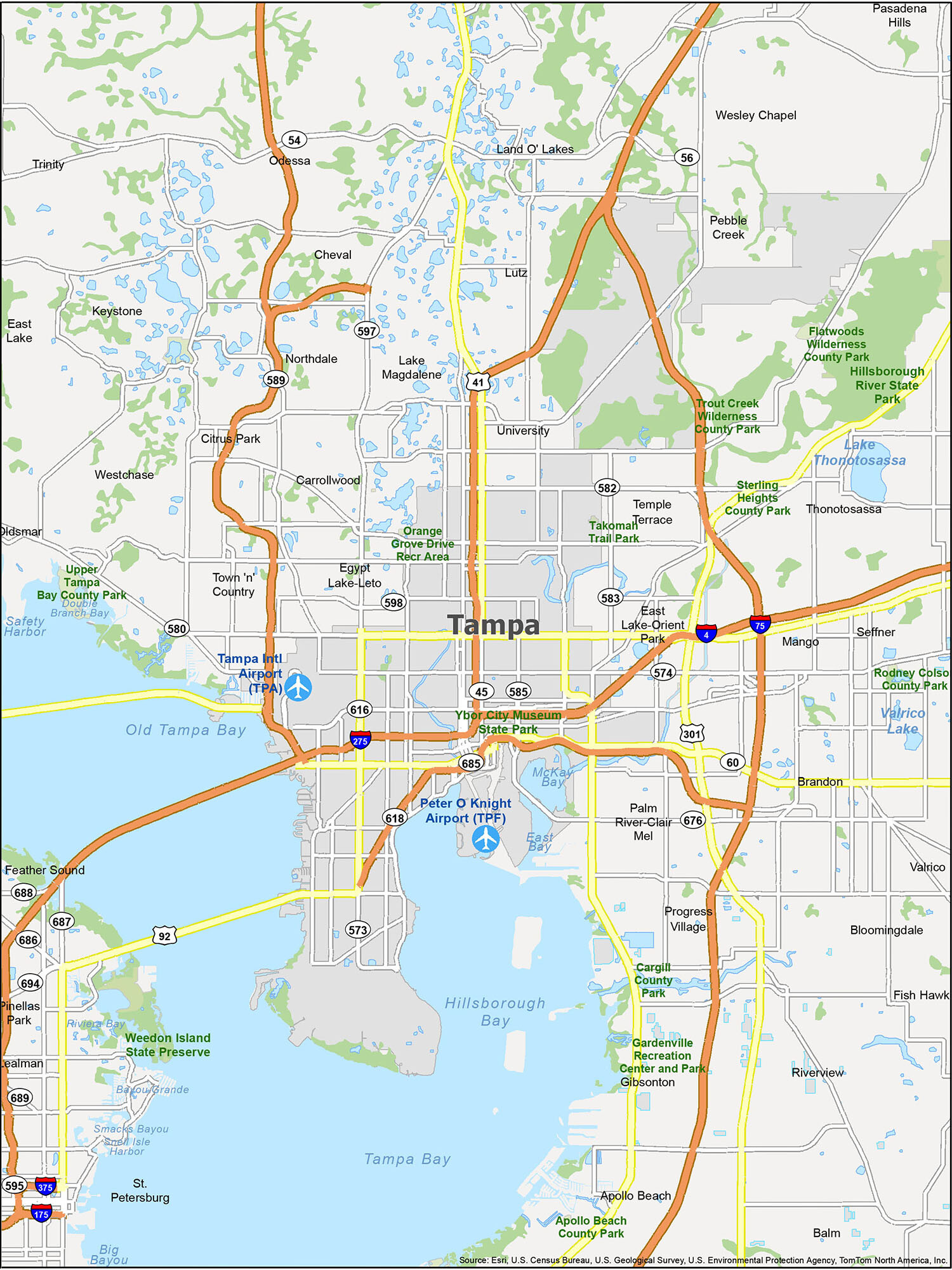
Planning a trip to Tampa Florida can be simplified by using a map of the city. This road map of Tampa will help you find interstates, highways, and major roads in the area. Download this map and plan your trip to Tampa today to make your vacation easier! But for any travel outside the city, you should also have a Florida road map with highway and road information.
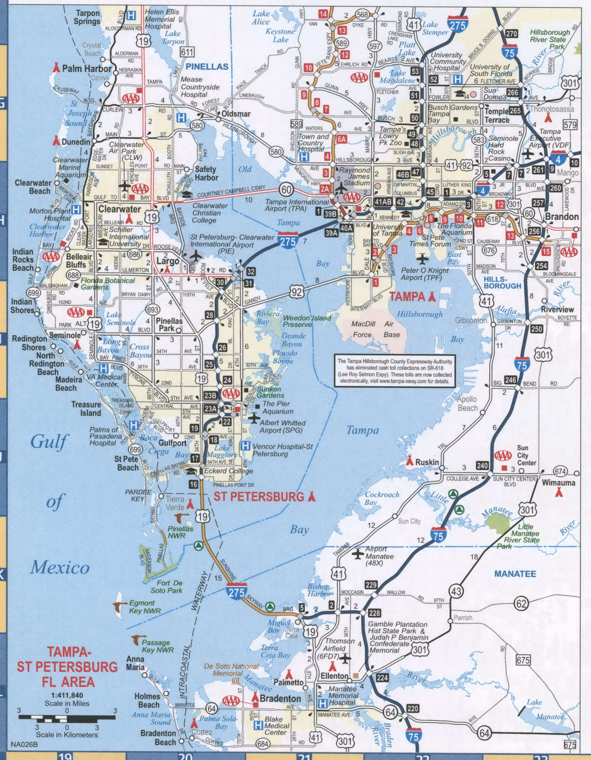
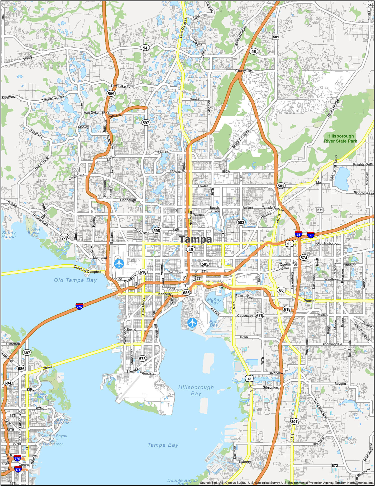
Explore Tampa, Florida with a reference map to get a better idea of the city. With this map, you can find airports, bays, cities, and census-designated places (CDP) such as Oldsmar, Pinellas Park, St. Petersburg, Tampa, Temple Terrace, Apollo Beach, Balm, Bloomingdale, Brandon, Carrollwood, Cheval, Citrus Park, East Lake, East Lake-Orient Park, Egypt Lake-Leto, Feather Sound, Fish Hawk, Gibsonton, Keystone, Lake Magdalene, Land O’ Lakes, Lealman, Lutz, Mango, Northdale, Odessa, Palm River-Clair Mel, Pebble Creek, Progress Village, Riverview, Seffner, Thonotosassa, Town ‘n’ Country, Trinity, University, Valrico, Wesley Chapel, and Westchase. This is an informative way to learn more about the city and explore the area.
10 things to do in Tampa city
Tampa is a popular destination for tourists and locals alike. Whether you’re looking for a day of family fun or an adventurous outing, you’ll find something that suits your needs. With this map, you can easily locate the top attractions and make the most of your time in Tampa.
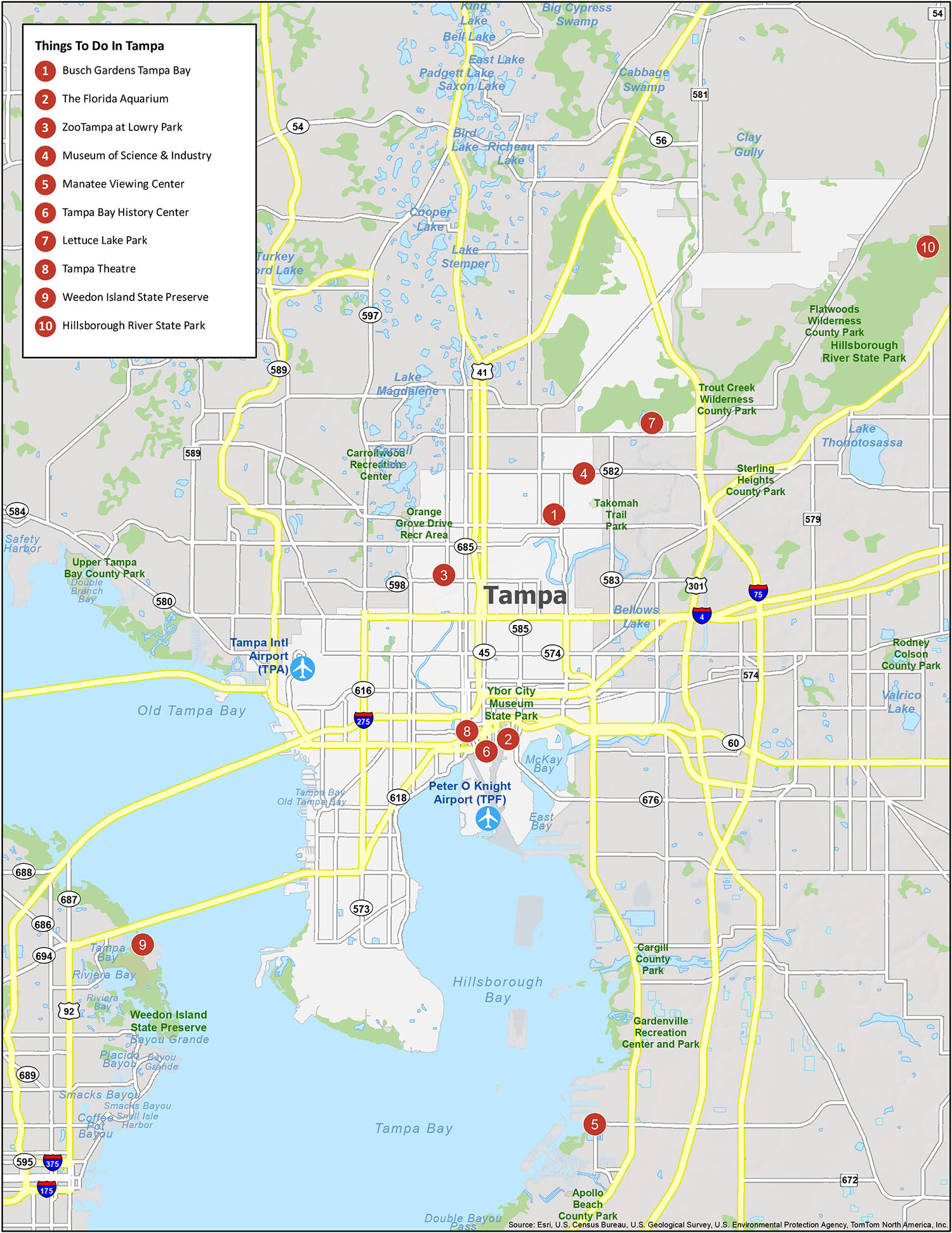
Tampa is a vibrant destination with plenty of exciting attractions to explore. From Busch Gardens Tampa Bay to the Museum of Science & Industry, there’s something for everyone. Get the most out of your visit by using this map to easily locate the top attractions in the city. Enjoy your time in sunny Tampa!
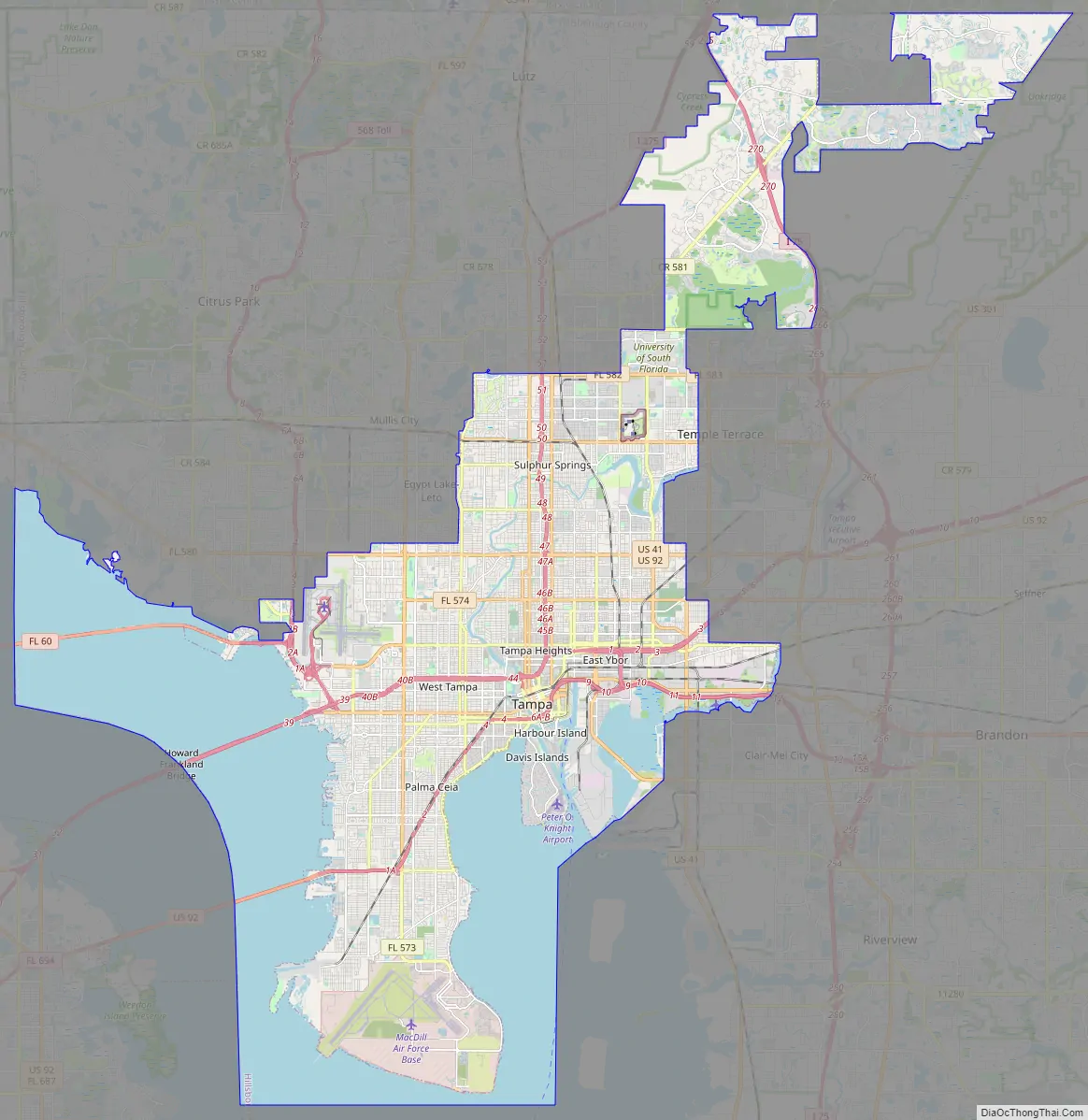
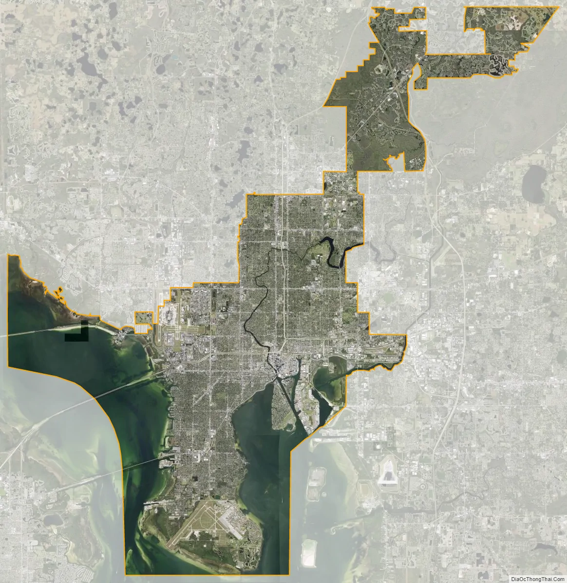
Tampa city Satellite Map
Geography
Topography
According to the United States Census Bureau, the city has a total area of 175.3 sq mi (453.9 km), including 113.4 sq mi (293.7 km) of land and 61.8 sq mi (160.1 km) (35.3%) of water. The highest point in the city is only 48 ft (15 m) above sea level. Tampa is bordered by two bodies of water, Old Tampa Bay and Hillsborough Bay, which flow together to form Tampa Bay, which in turn flows into the Gulf of Mexico. The Hillsborough River flows into Hillsborough Bay, passing directly in front of Downtown Tampa and supplying Tampa’s main source of fresh water. The Palm River is a smaller river flowing from just east of the city into McKay Bay, which is a smaller inlet, sited at the northeast end of Hillsborough Bay. Tampa’s geography is marked by the Interbay Peninsula which divides Hillsborough Bay (the eastern) from Old Tampa Bay (the western).
Climate
The Tampa Bay area has a humid subtropical climate (Köppen Cfa), although due to its location on the Florida peninsula on Tampa Bay and the Gulf of Mexico, it shows some characteristics of a tropical climate. Tampa’s climate generally features hot and humid summers with frequent thunderstorms and dry and mild winters. Average highs range from 71 to 91 °F (22 to 33 °C) year round, and lows 53 to 77 °F (12 to 25 °C). The city of Tampa is split between two USDA climate zones. According to the 2012 USDA Plant Hardiness Zone Map, Tampa is listed as USDA zone 9b north of Kennedy Boulevard away from the bay and 10a near the shorelines and in the interbay peninsula south of Kennedy Boulevard. Zone 10a is about the northern limit of where coconut palms and royal palms can be grown, although some specimens do grow in northern Tampa. Recently, certain palm tree species in the area, along with the rest of the state, have been and continue to be severely affected by a plant disease called Texas phoenix palm decline, which has caused a considerable amount of damage to various local palm tree landscapes and threatens the native palm tree species in the region.
Tropical storms
Though threatened by tropical systems almost every hurricane season (which runs from June 1 to November 30), Tampa seldom feels major effects from tropical storms or hurricanes. No hurricane has made landfall in the immediate Tampa Bay area since the category 4 1921 Tampa Bay hurricane made landfall near Tarpon Springs and caused extensive damage throughout the region.
Over the past few decades, four major hurricanes were forecast to hit the Tampa Bay area from the south-southwest, which is a worse-case track that would result in a maximum storm surge event: Hurricane Donna (1960), Hurricane Charley (2004), Hurricane Irma (2017), and Hurricane Ian (2022). However, all of these storms veered to the east or northeast before reaching Tampa Bay and instead made landfall down the coast, resulting in serious damage in southwest Florida. Irma had the greatest effect on Tampa. It made landfall near Marco Island on September 10, 2017, and moved due north, passing through eastern Hillsborough County as a Category 1 storm and causing widespread issues in the area, particularly disrupting the electrical grid for several days.
Because of tremendous population growth and coastal development in the century since the last hurricane landfall combined with rising sea levels due to climate change, the Tampa Bay Area is considered one of the most vulnerable regions in the world to a direct hit from a major storm.
Seasonal trends
Summertime weather patterns predominate from late May through early October, which is the region’s rainy season. Daily weather is very consistent during this period, with daytime highs usually reaching the average high of about 91 °F (33 °C), lows usually in the mid- to upper 70s °F (23–25 °C), high humidity, and a regular chance of rain, especially in the afternoon. Mainly due to the proximity of large bodies of water, the official high temperature has never hit 100 °F (37.8 °C) – the all-time record high temperature is 99 °F (37 °C), first recorded on June 5, 1985, and tied on June 26, 2020. Afternoon thunderstorms are regularly generated by the interaction of the Gulf and Atlantic sea breezes and are such a regular occurrence during the summer that the Tampa Bay area and nearby inland areas of Central Florida are recognized as the “Lightning Capital of North America”. Afternoon thundershowers occasionally intensify into a severe thunderstorm, bringing heavy downpours, frequent lightning, strong straight-line winds, and sometimes hail.
Average temperatures gradually fall beginning in September, and average daily rainfall amounts also decrease as autumn progresses; November is usually Tampa’s driest month. However, rain totals in the fall can be augmented by passing tropical systems, which can dump several inches of rain.
Winter in the area is generally dry and cooler. Average high temperatures range from the low to mid-70s °F (21–23 °C) during the day to the low to mid-50s °F (11–13 °C) at night. Occasional cold fronts push through the area during the season, usually bringing a brief period of rain followed by daytime highs in the 50s °F (10–13 °C) and nighttime lows near 40 °F (5 °C) for a day or two. Tampa experiences occasional frosts, with an annual mean minimum temperature of 32.8 °F (0.4 °C)
Since the Tampa area is home to a diverse range of freeze-sensitive agriculture and aquaculture, hard freezes, although quite rare, are a major concern. Hard freezes (defined as a temperature of 28 °F (−2.2 °C) or below for several hours) occur rarely in the Tampa area; every five to twenty years depending on the exact location. The last widespread freeze occurred on the morning of January 18, 2018, when the official temperature at Tampa International Airport dropped to 29 °F (−2 °C). The lowest temperature ever recorded in Tampa was 18 °F (−8 °C) on December 13, 1962. The only snowfall officially recorded in Tampa occurred on January 19, 1977, with local accumulations ranging between a trace and 0.2 in (0.5 cm).
Tampa sees a slow increase in average temperatures beginning in mid-February, and spring brings mostly warm and sunny weather to the area. While temperatures in late spring approach summertime values, the rainy season does not usually begin until June, leading to the threat of brush fires from approximately late March until May. Occasionally, a late-season cold front pushes through the area, potentially bringing a brief round of severe weather followed by a few days of unseasonably cool temperatures.
See also
Map of Florida State and its subdivision:- Alachua
- Baker
- Bay
- Bradford
- Brevard
- Broward
- Calhoun
- Charlotte
- Citrus
- Clay
- Collier
- Columbia
- Desoto
- Dixie
- Duval
- Escambia
- Flagler
- Franklin
- Gadsden
- Gilchrist
- Glades
- Gulf
- Hamilton
- Hardee
- Hendry
- Hernando
- Highlands
- Hillsborough
- Holmes
- Indian River
- Jackson
- Jefferson
- Lafayette
- Lake
- Lee
- Leon
- Levy
- Liberty
- Madison
- Manatee
- Marion
- Martin
- Miami-Dade
- Monroe
- Nassau
- Okaloosa
- Okeechobee
- Orange
- Osceola
- Palm Beach
- Pasco
- Pinellas
- Polk
- Putnam
- Saint Johns
- Saint Lucie
- Santa Rosa
- Sarasota
- Seminole
- Sumter
- Suwannee
- Taylor
- Union
- Volusia
- Wakulla
- Walton
- Washington
- Alabama
- Alaska
- Arizona
- Arkansas
- California
- Colorado
- Connecticut
- Delaware
- District of Columbia
- Florida
- Georgia
- Hawaii
- Idaho
- Illinois
- Indiana
- Iowa
- Kansas
- Kentucky
- Louisiana
- Maine
- Maryland
- Massachusetts
- Michigan
- Minnesota
- Mississippi
- Missouri
- Montana
- Nebraska
- Nevada
- New Hampshire
- New Jersey
- New Mexico
- New York
- North Carolina
- North Dakota
- Ohio
- Oklahoma
- Oregon
- Pennsylvania
- Rhode Island
- South Carolina
- South Dakota
- Tennessee
- Texas
- Utah
- Vermont
- Virginia
- Washington
- West Virginia
- Wisconsin
- Wyoming


