Bakersfield is a city in Kern County, California, United States. It is the county seat and largest city of Kern County. The city covers about 151 sq mi (390 km) near the southern end of the San Joaquin Valley and the Central Valley region. Bakersfield’s population as of the 2020 census was 403,455, making it the 48th most populous city in the United States of America and the 9th most populous city in California. The Bakersfield–Delano Metropolitan Statistical Area, which includes all of Kern County, had a 2020 census population of 909,235, making it the 62nd largest metropolitan area in the United States. The urban area that includes Bakersfield and areas immediately around the city, such as East Bakersfield, Oildale, and Rosedale, has a population of 570,235.
Bakersfield is a significant hub for both agriculture and energy production. Kern County is the most productive oil-producing county in California and the fourth most productive agricultural county (by value) in the United States. Industries in and around Bakersfield include natural gas and other energy extraction, mining, petroleum refining, distribution, food processing, and corporate regional offices. The city is the birthplace of the country music genre known as the Bakersfield sound.
| Name: | Bakersfield city |
|---|---|
| LSAD Code: | 25 |
| LSAD Description: | city (suffix) |
| State: | California |
| County: | Kern County |
| Incorporated: | 1873–1876 |
| Elevation: | 404 ft (123 m) |
| Land Area: | 149.81 sq mi (388.01 km²) |
| Water Area: | 1.46 sq mi (3.79 km²) |
| Population Density: | 2,700/sq mi (1,000/km²) |
| ZIP code: | 93220, 93301–93309, 93311–93314, 93380–93390, 93399 |
| Area code: | 661 |
| FIPS code: | 0603526 |
| Website: | www.bakersfieldcity.us |
Bakersfield, California is a city known for its sunshine and warm weather. It is one of the fastest-growing cities in California due to its well-developed economy and location in the south-central region of California. If you plan to go, check out this Bakersfield Map collection for one of the most underestimated cities in California. It is just a hop, skip, and jump away from Los Angeles, California, and a short distance of 110 miles (180 km) away from Sequoia National Park.
Our Bakersfield map shows highways, roads, and other major landmarks. In addition, our map of Bakersfield lists the top 10 things to do in the city. To get a larger perspective, you can check out the California map to see where it all fits in statewide.
Online Interactive Map
Click on ![]() to view map in "full screen" mode.
to view map in "full screen" mode.
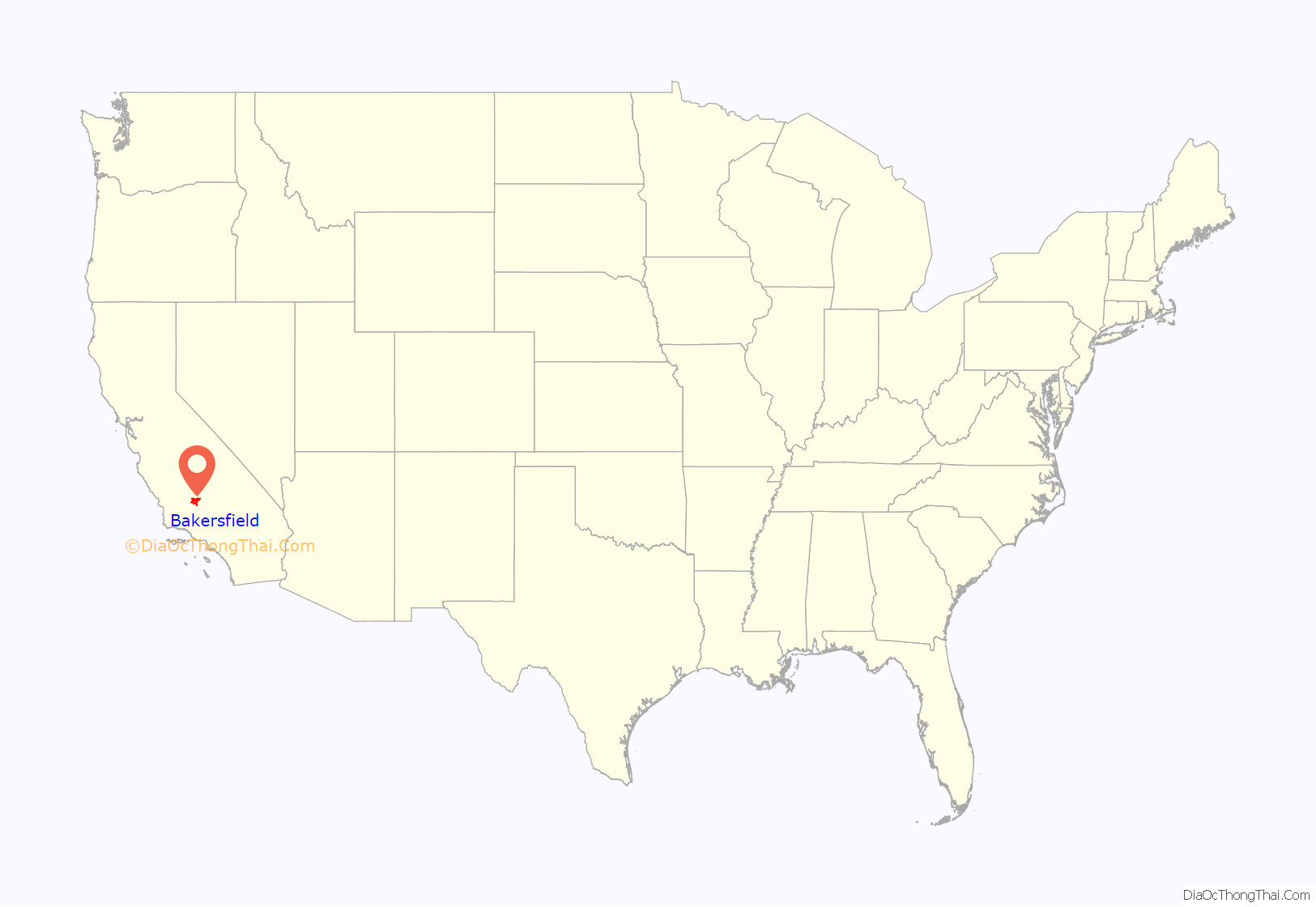
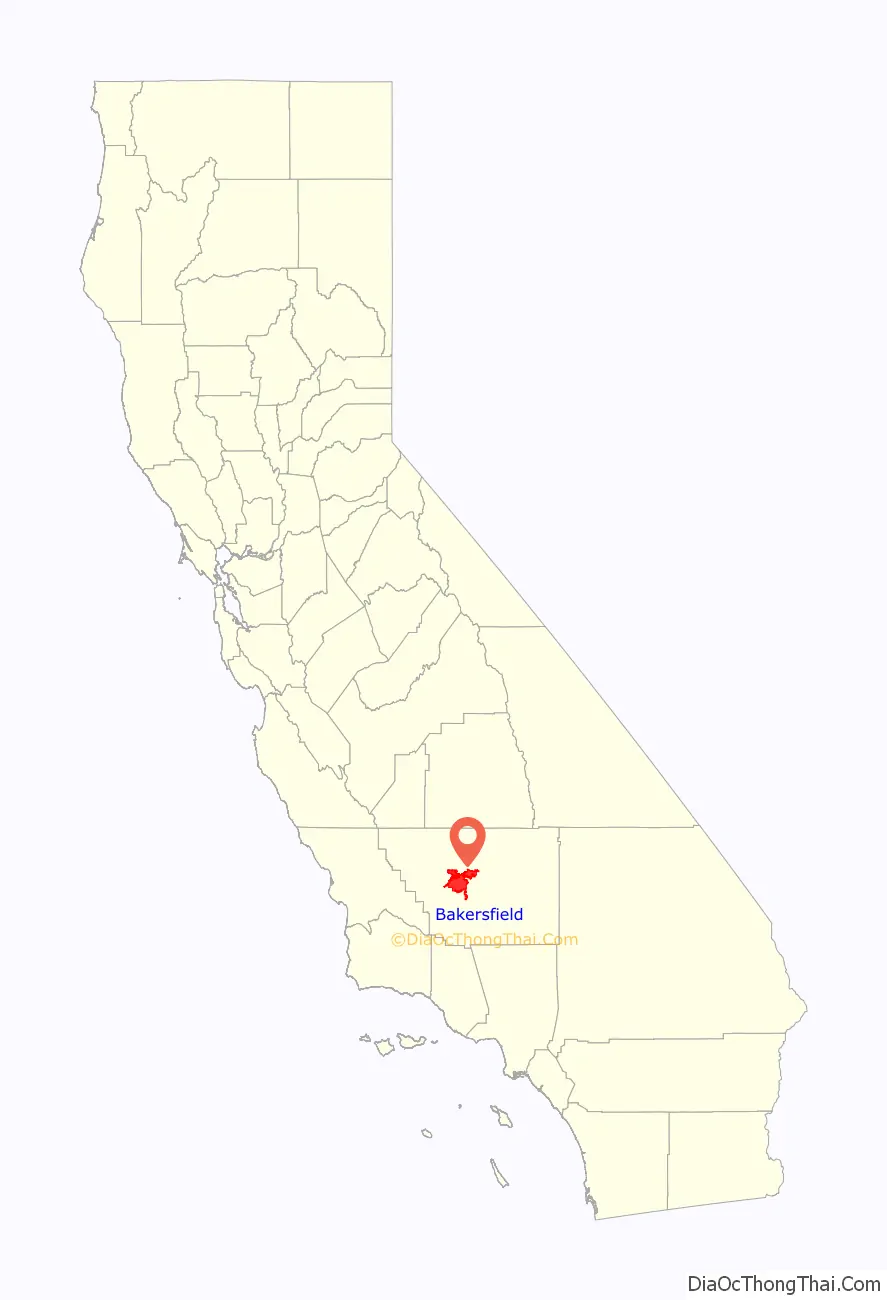
Bakersfield is located in southern California and is the most populous city in Kern County. This interactive map allows you to easily zoom in and out, find the location you are looking for, and explore Bakersfield, California. Discover the best restaurants, attractions, and more from our interactive map of Bakersfield.
Bakersfield location map. Where is Bakersfield city?
History
Archaeological evidence indicates the presence of Native American settlements dating back thousands of years. Upon Spanish arrival, present-day Bakersfield was inhabited by the Yowlumne, a Yokuts people. Yowlumne accounts indicate that the village of Woilu was situated in the bounds of the present city.
The Yokuts of the region lived in lodges along the branches of the Kern River delta and hunted antelope, tule elk, deer, bear, fish, and game birds.
In 1776, Spanish missionary Francisco Garcés became the first European to explore the area. Recording his May 1 arrival to a Yokuts village along the Kern River, immediately northeast of present-Bakersfield, Garcés wrote,
Given the remoteness and inaccessibility of the region, the Yokuts remained largely isolated from further contact until after the Mexican War of Independence, when Mexican settlers began to migrate to the area. Following the discovery of gold in California in 1848, settlers flooded into the San Joaquin Valley. In 1851, gold was discovered along the Kern River in the southern Sierra Nevada, and in 1865, oil was discovered in the valley. The Bakersfield area, once a tule reed-covered marshland, was first known as Kern Island to the handful of pioneers, who built log cabins there in 1860. The area was subject to periodic flooding from the Kern River, which occupied what is now the downtown area, and experienced outbreaks of malaria.
Bakersfield is the fifth-largest majority-Hispanic city in the United States, with 53% of its population being Hispanic in 2020.
Founding
In 1861, disastrous floods swept away the original settlement founded in 1860 by the German-born Christian Bohna. Among those attracted to the area by the California gold rush was Thomas Baker, a lawyer and former colonel in the militia of Ohio, his home state. Baker moved to the banks of the Kern River in 1863, at what became known as Baker’s Field, which became a stopover for travelers. By 1870, with a population of 600, what is now known as Bakersfield was becoming the principal town in Kern County.
In 1873, Bakersfield was officially incorporated as a city, and by 1874, it officially replaced the town of Havilah as the county seat. Alexander Mills was hired as the city marshal, a man one historian would describe as “… an old man by the time he became Marshal of Bakersfield, and he walked with a cane. But he was a Kentuckian, a handy man with a gun, and not lacking in initiative and resource when the mood moved him.” Businessmen and others began to resent Mills, who was cantankerous and high-handed in his treatment of them. Wanting to fire him but fearing reprisals, they came up with a scheme to disincorporate, effectively leaving him without an employer. According to local historian Gilbert Gia the city was also failing to collect the taxes it needed for services. In 1876, the city voted to disincorporate. For the next 22 years, a citizen’s council managed the community.
By 1880, Bakersfield had a population of 801 with 250 of Chinese descent.
By 1890, it had a population of 2,626. Migration from Texas, Louisiana, Oklahoma, and Southern California brought new residents, who were mostly employed by the oil industry.
The city reincorporated on January 11, 1898.
1952 earthquake
On July 21, 1952, an earthquake struck at 4:52 am Pacific Daylight Time. The earthquake, which measured 7.5 on the moment magnitude scale and was felt from San Francisco to the Mexican border, destroyed the nearby communities of Tehachapi and Arvin. The earthquake’s destructive force bent cotton fields into U shapes, slid a shoulder of the Tehachapi Mountains across all four lanes of the Ridge Route, collapsed a water tower creating a flash flood, and destroyed the railroad tunnels in the mountain chain. Bakersfield was somewhat spared, experiencing minor architectural damage without loss of life.
A large aftershock occurred on July 29, and did minor architectural damage, but raised fears that the flow of the Friant-Kern Canal could be dangerously altered, potentially flooding the city and surrounding areas.
Aftershocks continued for the next month, and on August 22 at 3:42 pm, another earthquake, measured at 5.8, struck directly under the city’s center in the most densely populated area of the southern San Joaquin Valley. Four people died in the aftershock, and many of the town’s historic structures sustained heavy damage.
1970 to 2010
Between 1970 and 2010, Bakersfield grew 400% (from 70,000 to 347,483), making it one of the fastest-growing cities in California.
Bakersfield’s close proximity to mountain passes, primarily the Tejon Pass on Interstate 5 between the Greater Los Angeles Area and the San Joaquin Valley, has made the city a regional transportation hub.
In 1990, Bakersfield was one of 10 U.S. communities to receive the All-America City Award from the National Civic League.
In 2010, the Bakersfield MSA had a gross metropolitan product of $29.466 billion, making it the 73rd-largest metropolitan economy in the United States.
Historic architecture and preservation
Bakersfield has a number of buildings and locations that have been designated as historic sites at the national, state, and city levels. Five buildings have been listed on the National Register of Historic Places (NRHP), including the First Baptist Church (NRHP 1/2/79); Baker Street Library (NRHP 4/1/81) and Bakersfield Californian Building (NRHP 3/10/83). Four sites have been designated as California Historical Landmarks, including Garces Memorial Circle (designated in 1937) and the Colonel Thomas Baker Memorial (designated in 1944). In addition, 16 sites have been locally designated on the Bakersfield Register of Historic Places, including the Fox Theater (designated 8/24/94) and Kern County Chamber of Commerce Building (designated 3/12/08). With only 16 sites on its local register (compared to more than 300 sites designated by the City of Fresno), Bakersfield has been criticized for its lack of focus on historic preservation.
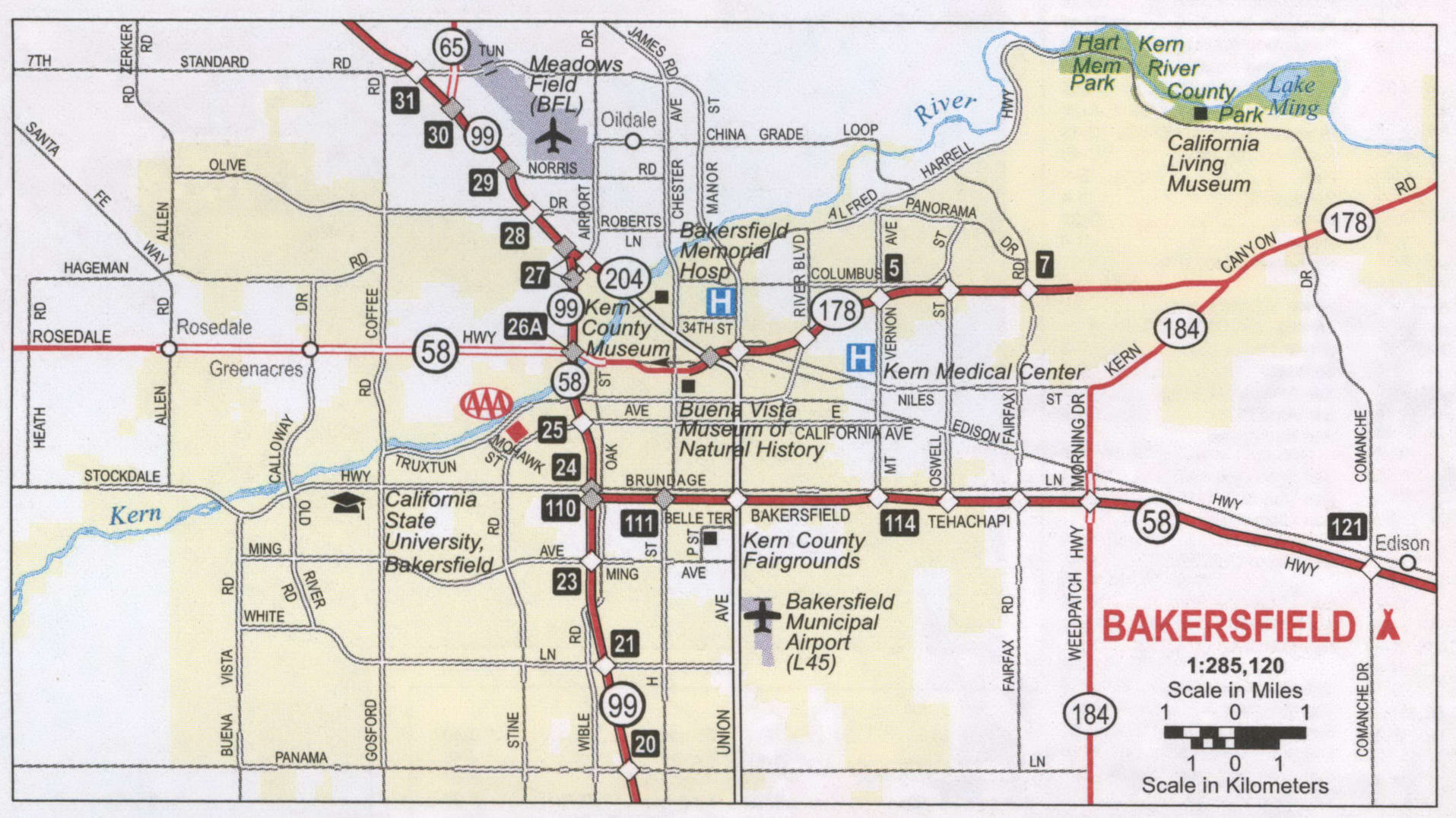
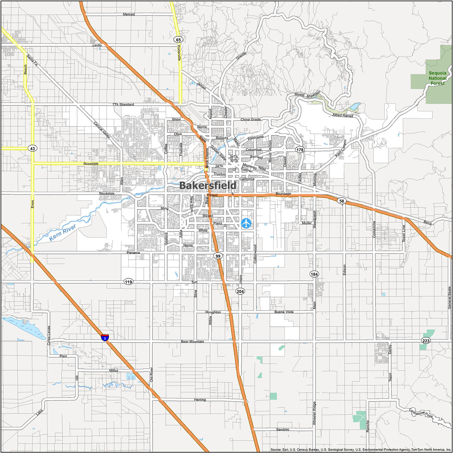
Bakersfield Road Map
Whether you’re visiting Bakersfield or looking to get around town, this road map can help you navigate the city streets. It can also help you explore attractions around the heart of California, from parks to mountain ranges, without fear of getting lost.
Interstate Highways: I-5
US Highways: 58, 99, 178, 184, 204, Rosedale Hwy, Stockdale Hwy, Taft Hwy
Major Roads: 23rd St, 24th St, 30th St, 7th Standard Rd, Airport Dr, Allen Rd, Brundage Ln, Buck Owens Blvd, California Ave, Chester Ave, Coffee Rd, Cottonwood Rd, Dr. Martin Luther King Jr Blvd, Enos Ln, Espee St, Frontage Rd, Golden State Ave, Gosford Rd, Kern Canyon Rd, Manor St, Ming Ave, Monterey St, Mount Vernon Ave, New Stine Rd, Niles St, Oak St, Old River Rd, Olive Dr, Oswell St, Pacific St, Panama Ln, Parent St, Real Rd, Richland St, Rio Mirada Dr, Stine Rd, Union Ave, Union Ave Loop, White Ln, Wible Rd
Whether you’re visiting Bakersfield or trying to get around town, this road map can be a great help in navigating the city streets. It can also help you explore attractions around the heart of California, from parks to mountain ranges, without fear of getting lost. With this road map, you will never have to worry about getting lost while travelling around California.
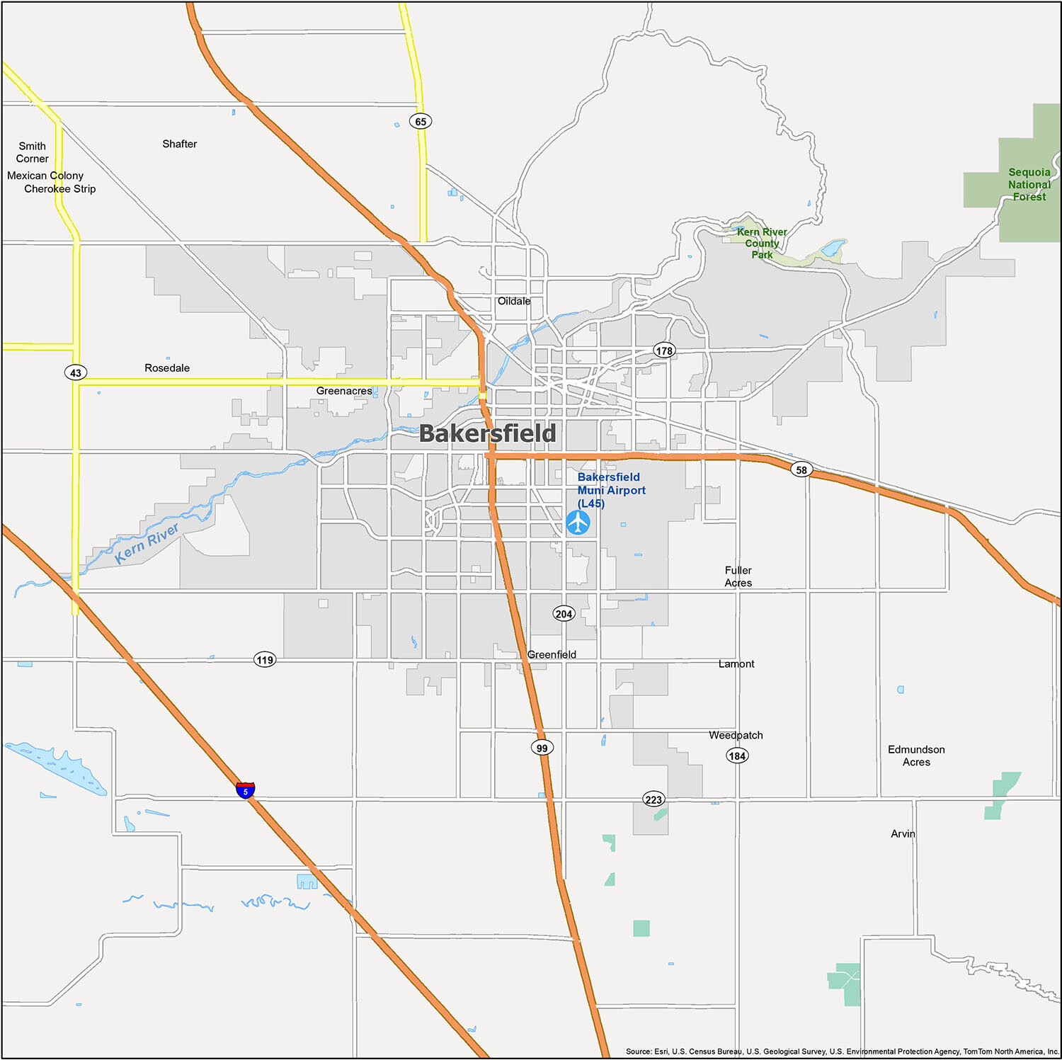
Bakersfield, California: A Rough and Ready Town
Bakersfield, California is a rough and ready town with a population of almost 400,000 people. Founded in 1869, Bakersfield is known for its oil fields and the people who work in them. The city is home to a number of cities and Census-Designated Places (CDPs), including Arvin, Bakersfield, Shafter, Cherokee Strip, Edmundson Acres, Fuller Acres, Greenacres, Greenfield, Lamont, Mexican Colony, Oildale, Rosedale, Smith Corner, and Weedpatch. The nearest airport is Bakersfield Municipal Airport (L45).
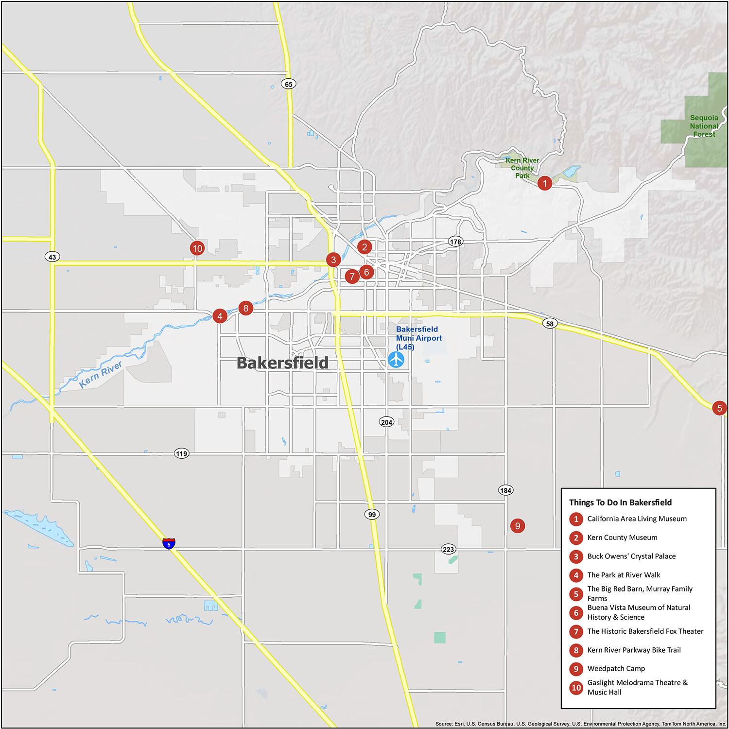
10 things to do in Bakersfield city
Bakersfield is a city full of life and culture. Tourist maps are a great way to explore the area and find the best places to visit and things to do. With this map, you can find all the popular attractions, including the California Area Living Museum, Kern County Museum, Buck Owens’ Crystal Palace, The Park at River Walk, The Big Red Barn, Murray Family Farms, Buena Vista Museum of Natural History & Science, The Historic Bakersfield Fox Theater, Kern River Parkway Bike Trail, Weedpatch Camp, and the Gaslight Melodrama Theatre & Music Hall. You’re also just a short distance away from the beautiful Kern River Canyon, which is known for its stunning hiking trails and views.
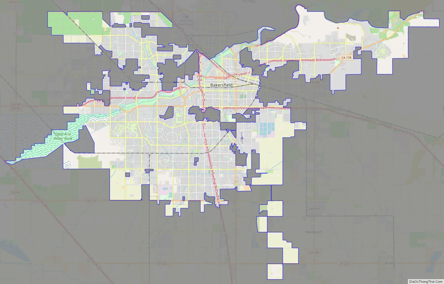
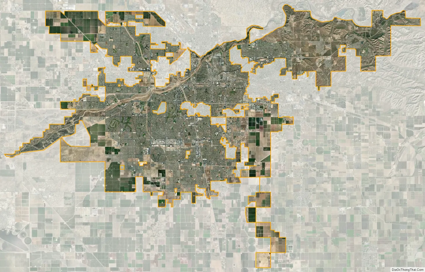
Bakersfield city Satellite Map
Geography
Bakersfield lies near the southern “horseshoe” end of the San Joaquin Valley, with the southern tip of the Sierra Nevada just to the east. The city limits extend to the Sequoia National Forest, at the foot of the Greenhorn Mountain Range and at the entrance to the Kern Canyon. To the south, the Tehachapi Mountains, rising more than a vertical mile, feature the historic Tejon Ranch. To the west is the Temblor Range, behind which is the Carrizo Plain National Monument and the San Andreas Fault. The Temblor Range is about 35 mi (56 km) from Bakersfield across the valley floor.
According to the United States Census Bureau, the city has a total area of 143.6 sq mi (372 km), of which 142.2 sq mi (368 km) are land (98.99%) and 1.4 sq mi (3.6 km) are covered by water (1.01%).
At the 2000 census, the city had a total area of 114.4 sq mi (296 km), of which 113.1 sq mi (293 km) were land (98.86%) and 1.3 sq mi (3.4 km) were water-covered (1.14%).
Bakersfield lies around 110 mi (180 km) north of Los Angeles (about a 2-hour drive on I-5 and State Route 99) and about 275 mi (443 km) southeast of the state capital, Sacramento (about a 4-hour drive on State Route 99).
Hart Memorial Park is located in northeast Bakersfield along Alfred Harrell Highway.
Communities and neighborhoods
Bakersfield has historically referred to its regions by directional names. They include: North Bakersfield, Northeast, Southeast, South Bakersfield, Southwest, and Northwest. East Bakersfield generally refers to the former town of Sumner (later renamed East Bakersfield). As a result, the Northeast wraps around East Bakersfield.
Climate
Bakersfield has a hot arid climate (Köppen BWh), with very hot, dry summers, and winters that consist of mild days with chilly/cold nights. Rainfall is low in the city, averaging only 6.36 inches (161.5 mm) annually, with most of it falling in the winter. Bakersfield averages about 191 clear days a year. Bakersfield’s climate makes the region suitable for growing crops ranging from carrots to citrus and almonds.
Bakersfield summers are very hot with extended stretches of hot weather and 112 days per year with high temperatures of 90 °F (32.2 °C)+ (on average between April 18 and October 13); in addition, there are 36 days with highs of 100 °F (37.8 °C)+ (on average between June 2 and September 19), and 0.9 days with highs of 110 °F (43.3 °C)+. The frequency of 110 °F (43.3 °C) readings can significantly vary each year, with the record being 17 days in 1931. The most recent year to have more than 5 days of 110 °F (43.3 °C)+ temperature readings was 2017, with 7 days reaching or exceeding 110 °F (43.3 °C). Temperatures can be highly variable throughout the spring, summer and fall months every year, with triple digit temperature readings in May, and on rare occasion April, and October in addition to occasional high temperatures below 80 °F (26.7 °C) in June and September not being uncommon. The warmest month on record was July 2021, with an average temperature of 90 °F (32.2 °C). Except for occasional monsoons which may bring light rain, typically no rain or almost no rain will fall from May to September.
Winters feature mild daytime temperatures and chilly/cold nights. Frost and/or dense fog usually occurs in winter with accompanying low visibility, causing many schools to have fog delays. Winters will usually produce a very dense layer of fog from time to time. Due to years of prolonged drought and rapid development of many new neighborhoods around Bakersfield, the density of the fog and number of “fog days” has been steadily decreasing, while areas outside the city still experience thick fog. The official time frame for tule fog to form is about 5 months long – various days from November 1 to March 31. Most noticeable in summer and winter, the urban heat island phenomenon can be observed throughout various neighborhoods in Bakersfield. Areas closer to downtown and along the 99 freeway corridor can experience warmer temperatures at night than neighborhoods on the edge of the city limits and rural Kern County areas, with temperature differences up to 7 °F (4 °C) between these areas at any given time. On average, 10 mornings have freezing lows (on average between December 14 and January 24) annually, and the coldest night of the year typically bottoms out below 30 °F or −1.1 °C. On January 2, 2012, Bakersfield reached a record high of 82 °F (27.8 °C) for that year’s winter.
Spring and fall months typically feature mild to warm daytime high temperatures with cool nighttime low temperatures, but temperatures and precipitation can vary significantly depending on the year. More than 50 percent of Bakersfield’s annual precipitation falls between the months of January and March, with the remainder falling during late fall and early winter.
Snow is rare on the valley floor although frost may occur. The last snow fell on January 25, 1999, when the city received up to 6 inches (15 cm), with 3 inches (7.6 cm) at the airport. The record maximum temperature was 118 °F (47.8 °C) on July 28, 1908, and the record minimum temperature was 12 °F (−11.1 °C) on January 3, 1908. The most rainfall in one month was 5.82 inches (147.8 mm) in December 2010, and the maximum 24-hour rainfall was 2.29 inches (58.2 mm) on February 9, 1978. The wettest “rain year” has been from July 1997 to June 1998 with 14.73 inches (374.1 mm) and the driest from July 1933 to June 1934 with 2.26 inches (57.4 mm).
Air quality
Air quality is generally at its worst in fall and winter, due to the California wildfire season and colder temperatures forming an inversion layer, respectively. It is common for an inversion layer to form in the valley in the winter, in which temperatures can be warmer in the foothills above the valley with the valley itself being cooler. This can trap air pollution in Bakersfield and the surrounding valley areas for days, or even weeks at a time. This can typically be mediated by rain or strong winds. Emissions from agriculture, industry, rail freight and road traffic together create significant concentrations of air pollution. The extraction of oil and gas, a historic industry in the area, contributes to the poor air quality. Returning flowing water to the Kern River and along with trees is promoted as a way to improve air quality and enhance recreation in the city.
In 2015, Bakersfield had 28 days of “Unhealthy” and 1 day of “Very Unhealthy” air quality according to the EPA. This ranked 6th in the United States.
In 2016, Bakersfield had 14 days with “Unhealthy” air quality according to the EPA. This ranked 9th in the United States.
In 2017, Bakersfield had 23 days with “Unhealthy” air quality according to the EPA. Fourteen of those days were caused by the Thomas Fire located in adjacent Ventura and Santa Barbara counties. During that fire, Ventura and Santa Barbara counties experienced “Very Unhealthy” and “Hazardous” air quality.
In 2018, Bakersfield had 27 days with “Unhealthy” air quality according to the EPA. Most of these days were due to the second deadliest and most destructive wildfire season on record in California, behind the 2020 fire season. This ranked 6th in the United States.
In 2019, Bakersfield had only 6 days with “Unhealthy” air quality and 2 days with “Very Unhealthy” according to the EPA.
In 2020, Bakersfield had 31 days with “Unhealthy” air quality and 2 days with “Very Unhealthy” according to the EPA. This was largely caused by the record-breaking 2020 fire season.
In 2021, Bakersfield has recorded 28 days with “Unhealthy” air quality and 1 day with “Very Unhealthy” according to the EPA.
See also
Map of California State and its subdivision:- Alameda
- Alpine
- Amador
- Butte
- Calaveras
- Colusa
- Contra Costa
- Del Norte
- El Dorado
- Fresno
- Glenn
- Humboldt
- Imperial
- Inyo
- Kern
- Kings
- Lake
- Lassen
- Los Angeles
- Madera
- Marin
- Mariposa
- Mendocino
- Merced
- Modoc
- Mono
- Monterey
- Napa
- Nevada
- Orange
- Placer
- Plumas
- Riverside
- Sacramento
- San Benito
- San Bernardino
- San Diego
- San Francisco
- San Joaquin
- San Luis Obispo
- San Mateo
- Santa Barbara
- Santa Clara
- Santa Cruz
- Shasta
- Sierra
- Siskiyou
- Solano
- Sonoma
- Stanislaus
- Sutter
- Tehama
- Trinity
- Tulare
- Tuolumne
- Ventura
- Yolo
- Yuba
- Alabama
- Alaska
- Arizona
- Arkansas
- California
- Colorado
- Connecticut
- Delaware
- District of Columbia
- Florida
- Georgia
- Hawaii
- Idaho
- Illinois
- Indiana
- Iowa
- Kansas
- Kentucky
- Louisiana
- Maine
- Maryland
- Massachusetts
- Michigan
- Minnesota
- Mississippi
- Missouri
- Montana
- Nebraska
- Nevada
- New Hampshire
- New Jersey
- New Mexico
- New York
- North Carolina
- North Dakota
- Ohio
- Oklahoma
- Oregon
- Pennsylvania
- Rhode Island
- South Carolina
- South Dakota
- Tennessee
- Texas
- Utah
- Vermont
- Virginia
- Washington
- West Virginia
- Wisconsin
- Wyoming


