Long Beach is a city in Los Angeles County, California. It is the 42nd-most populous city in the United States, with a population of 466,742 as of 2020. A charter city, Long Beach is the seventh-most populous city in California.
Incorporated in 1897, Long Beach lies in Southern California in the southern part of Los Angeles County. Long Beach is approximately 20 miles (32 km) south of downtown Los Angeles, and is part of the Gateway Cities region. The Port of Long Beach is the second busiest container port in the United States and is among the world’s largest shipping ports. The city is over an oilfield with minor wells both directly beneath the city as well as offshore.
The city is known for its waterfront attractions, including the permanently docked RMS Queen Mary and the Aquarium of the Pacific. Long Beach also hosts the Grand Prix of Long Beach, an IndyCar race and the Long Beach Pride Festival and Parade. California State University, Long Beach, one of the largest universities in California by enrollment, is within the city.
| Name: | Long Beach city |
|---|---|
| LSAD Code: | 25 |
| LSAD Description: | city (suffix) |
| State: | California |
| County: | Los Angeles County |
| Incorporated: | December 13, 1897 |
| Elevation: | 52 ft (16 m) |
| Land Area: | 50.70 sq mi (131.32 km²) |
| Water Area: | 29.64 sq mi (76.77 km²) 2.22% |
| Population Density: | 9,205.96/sq mi (3,554.23/km²) |
| Area code: | 562 |
| FIPS code: | 0643000 |
| Website: | www.longbeach.gov |
This Long Beach map collection offers a range of maps to get you familiar with the area. From road and highway maps, to reference information, to things to do and explore, this collection has it all.
Explore the best things to do in Long Beach, California with our interactive Long Beach map. Get the most out of your trip by discovering the best attractions, restaurants, and saving time with this handy map collection.
Online Interactive Map
Click on ![]() to view map in "full screen" mode.
to view map in "full screen" mode.
Whether you’re looking for hotels, restaurants, or attractions, this map is a great reference tool. This map provides a birds-eye view of the city that you can zoom in and out of to see specific areas. Explore the beaches, shopping, and restaurants with ease to find the perfect vacation spot.
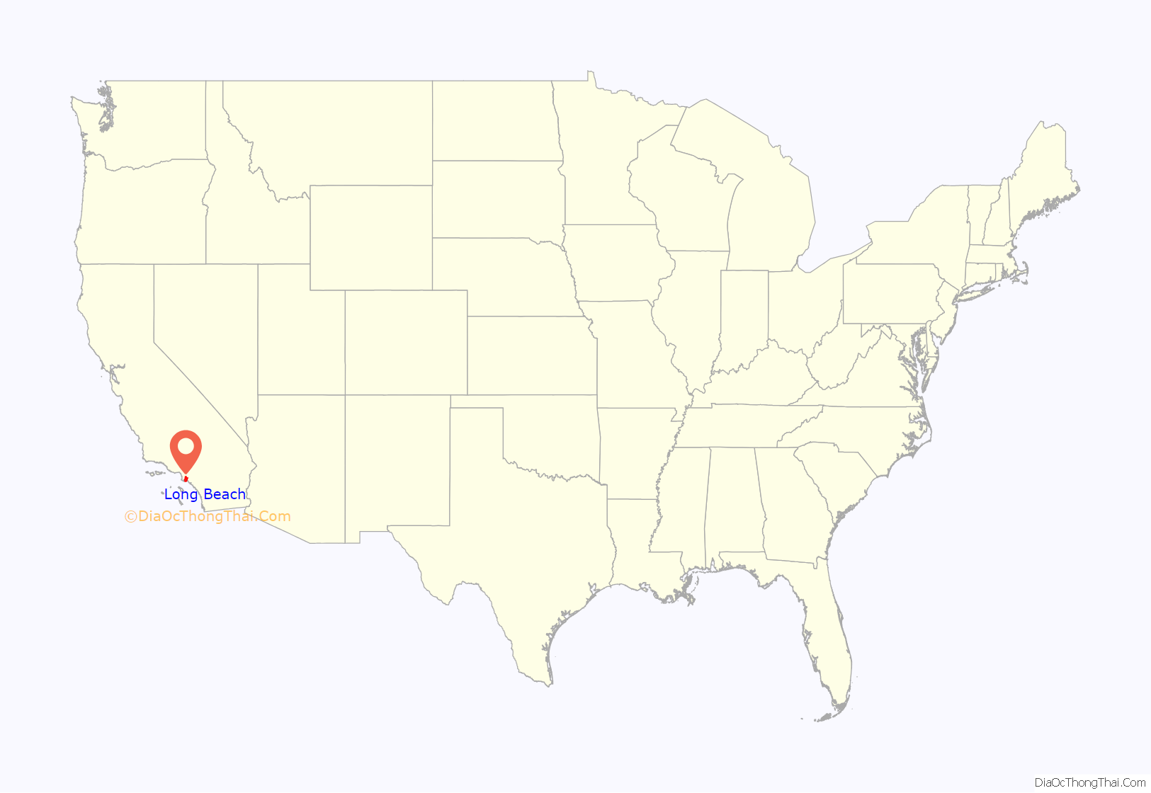
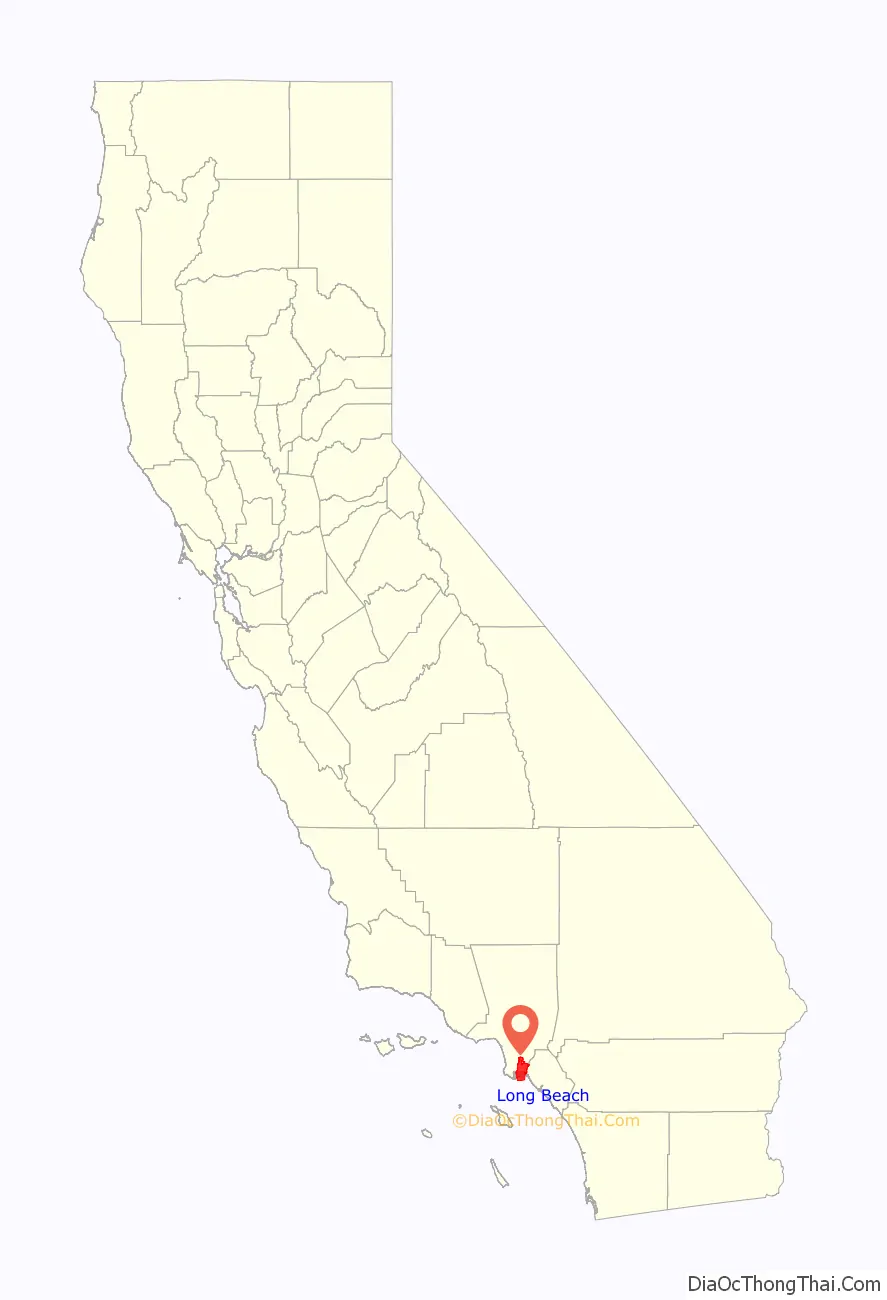
Long Beach location map. Where is Long Beach city?
History
Tongva period
Indigenous people have lived in coastal Southern California for over 10,000 years, and several successive cultures have inhabited the present-day area of Long Beach. By the 16th-century arrival of Spanish explorers, the dominant group was the Tongva, who had established at least three major settlements within the present-day city. Tevaaxa’anga was an inland settlement near the Los Angeles River, while Ahwaanga and Povuu’nga were coastal villages. Povuu’nga was particularly important to the Tongva, not only as a regional trading center and hub for fishermen, but for its deep ceremonial significance, being understood as their place of emergence as a people from which their lives began.
Spanish and Mexican period
In 1784, the Spanish Empire’s King Carlos III granted Rancho Los Nietos to Spanish soldier Manuel Nieto. The Rancho Los Cerritos and Rancho Los Alamitos were divided from this territory. The boundary between the two ranchos ran through the center of Signal Hill on a southwest to northeast diagonal. A portion of western Long Beach was originally part of the Rancho San Pedro. Its boundaries were in dispute for years, due to flooding changing the Los Angeles River boundary between Rancho San Pedro and Rancho Los Nietos.
By 1805, what had been the major Tongva village of Puvunga was thoroughly depleted of villagers, most of whom were brought to Mission San Gabriel for conversion and as a labor force. Many villagers died at the mission, which had a high rate of death, particularly among children, attributed to many factors like diseases that spread quickly in the close quarters of the mission’s walls, as well as torture, malnourishment, and overworking.
In 1843, Juan Temple bought Rancho Los Cerritos, having arrived in California in 1827 from New England. He built what is now known as the “Los Cerritos Ranch House”, a still-standing adobe which is a National Historic Landmark. Temple created a thriving cattle ranch and prospered, becoming the wealthiest man in Los Angeles County. Both Temple and his ranch house played important local roles in the Mexican–American War. On an island in the San Pedro Bay, Mormon pioneers made an abortive attempt to establish a colony (as part of Brigham Young’s plan to establish a continuous chain of settlements from the Pacific to Salt Lake).
Post-Conquest period
Following the U.S. Conquest of California, Temple had his Rancho Los Cerritos deeded to him by the Public Land Commission. In 1866, Temple sold Rancho Los Cerritos for $20,000 to the Northern California sheep-raising firm of Flint, Bixby & Company, which consisted of brothers Thomas and Benjamin Flint and their cousin Lewellyn Bixby. Two years previous Flint, Bixby & Co had also purchased along with Northern California associate James Irvine, three ranchos which would later become the city that bears Irvine’s name. To manage Rancho Los Cerritos, the company selected Lewellyn’s brother Jotham Bixby, the “Father of Long Beach”. Three years later, Bixby bought into the property and would later form the Bixby Land Company. In the 1870s, as many as 30,000 sheep were kept at the ranch and sheared twice yearly to provide wool for trade. In 1880, Bixby sold 4,000 acres (16 km) of the Rancho Los Cerritos to William E. Willmore, who subdivided it in hopes of creating a farm community, Willmore City. He failed and was bought out by a Los Angeles syndicate that called itself the “Long Beach Land and Water Company”. They changed the name of the community to Long Beach at that time.
Incorporation
The City of Long Beach was officially incorporated in 1897. The town grew as a seaside resort with light agricultural uses. The Pike was the most famous beachside amusement zone on the West Coast from 1902 until 1969; it offered bathers food, games and rides, such at the Sky Wheel dual Ferris wheel and Cyclone Racer roller coaster. Gradually the oil industry, Navy shipyard and facilities and port became the mainstays of the city. In the 1950s it was referred to as “Iowa by the sea”, due to a large influx of people from that and other Midwestern states. Huge picnics for migrants from each state were a popular annual event in Long Beach until the 1960s.
Another Bixby cousin, John W. Bixby, was influential in the city. After first working for his cousins at Los Cerritos, J.W. Bixby leased land at Rancho Los Alamitos. He put together a group: banker I.W. Hellman, Lewellyn and Jotham Bixby, and him, to purchase the rancho. In addition to bringing innovative farming methods to the Alamitos (which under Abel Stearns in the late 1850s and early 1860s was once the largest cattle ranch in the US), J.W. Bixby began the development of the oceanfront property near the city’s picturesque bluffs. Under the name Alamitos Land Company, J.W. Bixby named the streets and laid out the parks of his new city. This area would include Belmont Heights, Belmont Shore and Naples; it soon became a thriving community of its own. J.W. Bixby died in 1888 of apparent appendicitis. The Rancho Los Alamitos property was split up, with Hellman getting the southern third, Jotham and Lewellyn, the northern third, and J.W. Bixby’s widow and heirs keeping the central third. The Alamitos townsite was kept as a separate entity, but at first, it was primarily run by Lewellyn and Jotham Bixby, although I.W, Hellman (who had the largest single share) had a significant veto power, an influence made even stronger as the J.W. Bixby heirs began to side with Hellman more and more.
When Jotham Bixby died in 1916, the remaining 3,500 acres (14 km) of Rancho Los Cerritos was subdivided into the neighborhoods of Bixby Knolls, California Heights, Los Cerritos, North Long Beach and part of the city of Signal Hill.
Pine Avenue near 4th became the center of a large shopping district. Besides upscale Buffums (1912; expanded 1926), in 1929 alone Barker Brothers, the Hugh A. Marti Co., and Wise Company department stores built large new stores, Walker’s (1933), and nearby at American and 5th, Sears (1928) and Montgomery Ward (1929). It would remain popular until suburban malls sprung up starting in the 1950s. (see also: History of Retail in Southern California)
Oil was discovered in 1921 on Signal Hill, which split off as a separately incorporated city shortly afterward. The discovery of the Long Beach Oil Field, brought in by the gusher at the Alamitos oil well #1, made Long Beach a major oil producer; in the 1920s the field was the most productive in the world. In 1932, the even larger Wilmington Oil Field, fourth-largest in the United States, and which is mostly in Long Beach, was developed, contributing to the city’s fame in the 1930s as an oil town.
The M6.4 1933 Long Beach earthquake caused significant damage to the city and surrounding areas, killing a total of 120 people. Most of the damage occurred in unreinforced masonry buildings, especially schools. Pacific Bible Seminary (now known as Hope International University) was forced to move classes out of First Christian Church of Long Beach and into a small local home due to damage.
The Ford Motor Company built a factory called Long Beach Assembly at the then address in 1929 as “700 Henry Ford Avenue, Long Beach” where the factory began building the Ford Model A. Production of Ford vehicles continued after the war until 1960 when the plant was closed due to a fire, and January 1991 when the factory was demolished partially due to air quality remediation efforts. Ford had earlier opened a Factory in Los Angeles at the location of 12th Street and Olive, with a later factory built at East Seventh Street and Santa Fe Avenue after 1914.
Come 1938, the creation of Housing Authorities for both the City and County of Los Angeles were complete — and North Long Beach was to be home to the County Authority’s first order of business: the Carmelitos Housing Project, Southern California’s first affordable housing complex.
World War II
Long Beach, as a port city, had a relationship with the U.S. Navy even before the war. The city was part of the Battle of Los Angeles during World War II when observers for the United States Army Air Forces reported shells being fired from the sea. Anti-aircraft batteries fired into the night sky, although no planes were ever sighted.
Long Beach’s population grew substantially during and after the war, with workers being needed for wartime manufacturing and G.I. bill recipients seeking out homes in California. Suburbs were built by the Bixby land companies and others.
Before the war, Long Beach had a sizable Japanese-American population, who worked in the fish canneries on Terminal Island and owned small truck (produce) farms in the area. Due to fears on the coast, state officials persuaded the national government to remove Japanese nationals and Japanese Americans for internment in 1942 to inland facilities. Most did not return to the city after their release from the camps. Due to this and other factors, Japanese Americans now make up less than 1% of the population of Long Beach, but the Japanese Community Center and a Japanese Buddhist Church survive. The Japanese-American Cultural Center is over the Gerald Desmond Bridge and the Vincent Thomas Bridge in San Pedro.
Douglas Aircraft Company’s largest facility was its Long Beach plant, totaling 1,422,350 square feet (132,141 m). The first plane rolled out the door on December 23, 1941. The plant produced C-47 Skytrain transports, B-17 Flying Fortress bombers, and A-20 Havoc attack bombers simultaneously. Douglas merged with the McDonnell Aircraft Company in 1967 where the Douglas DC-8 and the McDonnell Douglas DC-9 were built. In 1997 McDonnell Douglas merged with Boeing, which made C-17 Globemaster transport planes in Long Beach until the closure of the manufacturing facility in 2015.
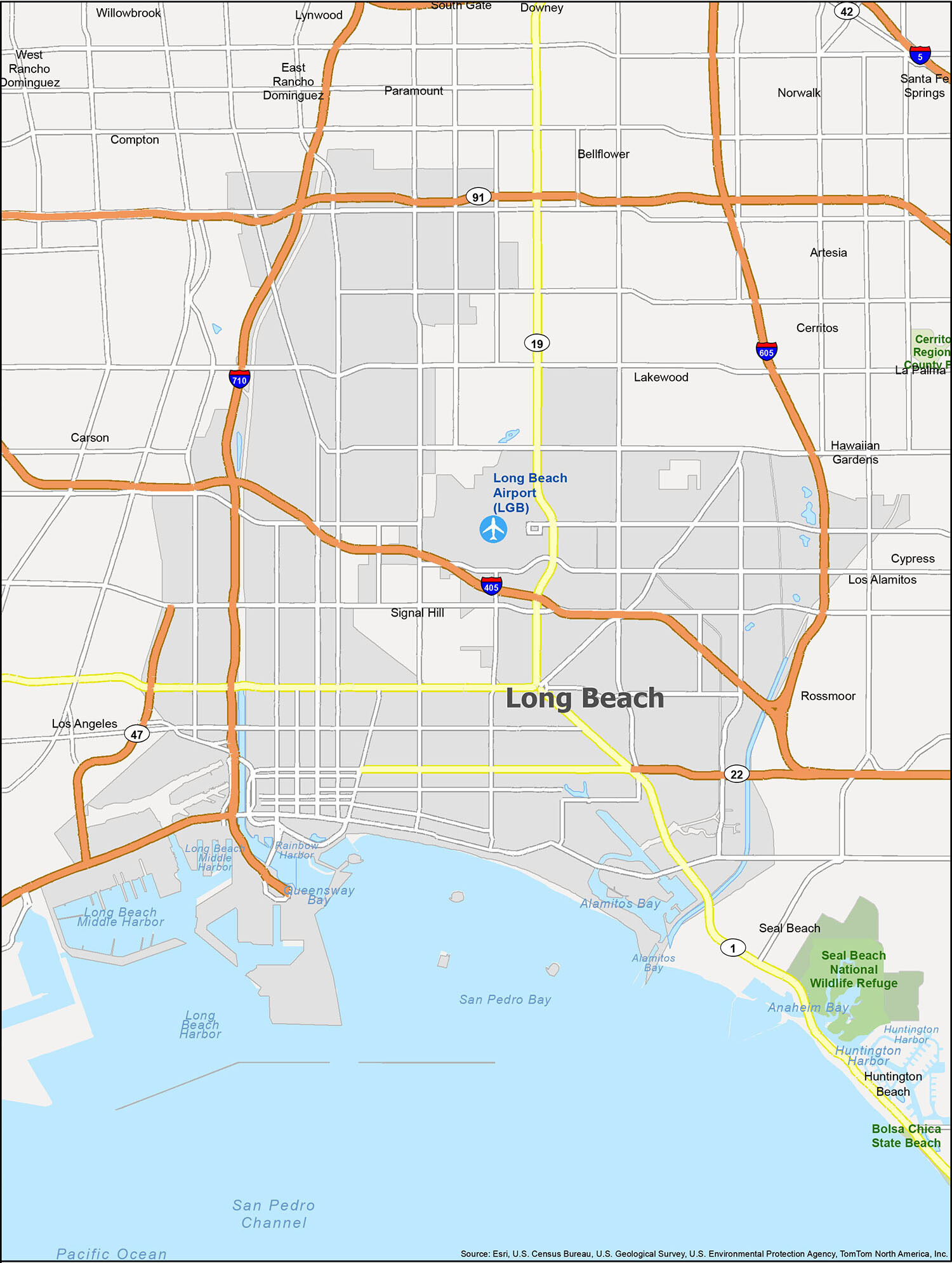
Long Beach Road Map
This map of Long Beach California gives you a glimpse of the road network of this city. With this map, you can explore the main roads, highways and freeways of the city and find the best way to get from point A to point B. The map also shows the Interstate Highways (I-405, I-605, I-710), US Highways (19, 22, 47, 91, 605, 710, Pacific Coast Hwy, Queens Hwy) and Freeways/Parkways (Long Beach Fwy). Major roads such as 6th St, 7th St, Alamitos Ave, Alamitos St, Atlantic Ave, California Ave, Carson St, Chestnut Pl, Harbor Plz, Harbor Scenic Dr, Lakewood Blvd, Magnolia Ave, Martin Luther King Jr Ave, Ocean Blvd, Orange Ave, Panorama Dr, Queens Way, Queensway Dr, Shoreline Dr and Willow St are also included in the map.
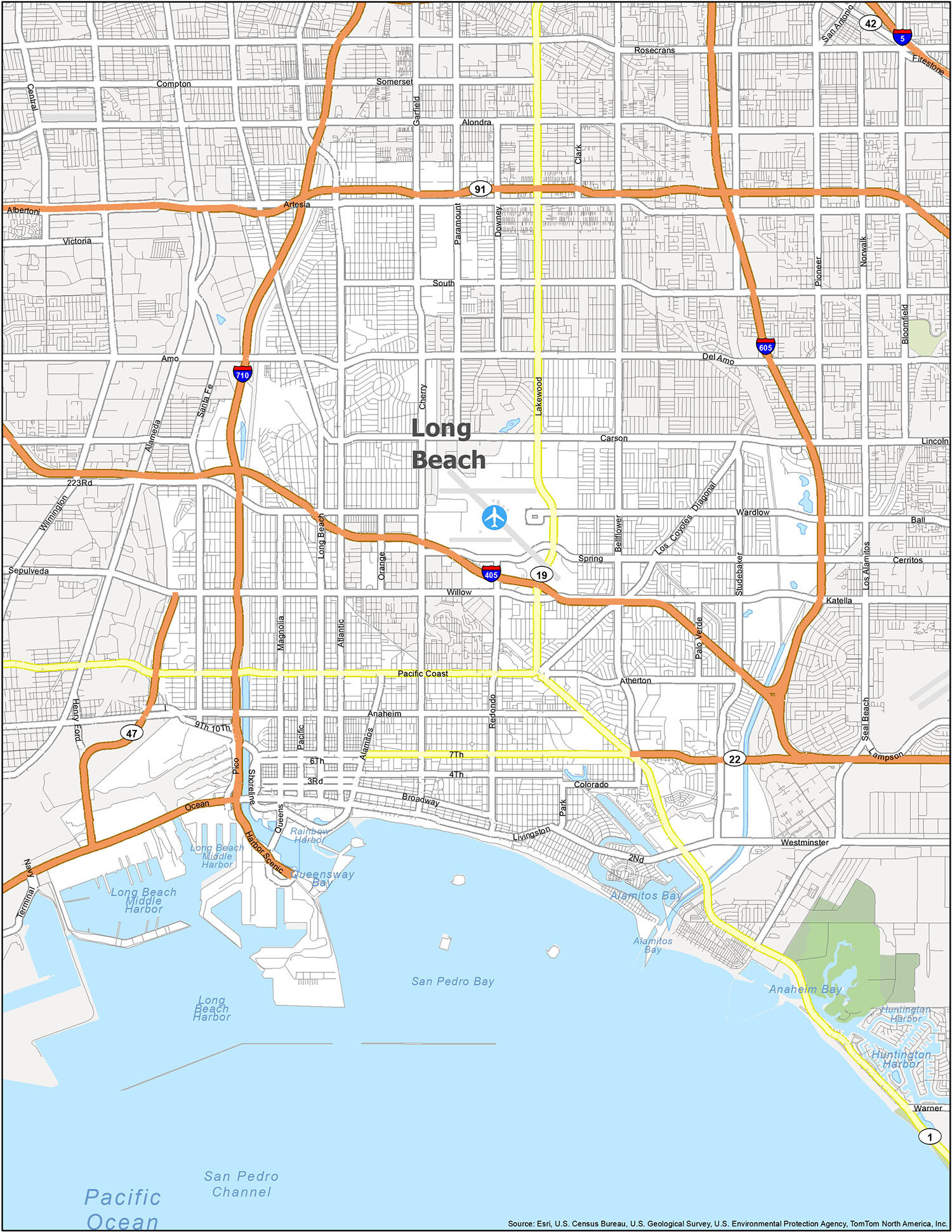
The Long Beach California map is a great resource for anyone looking to explore the area. It provides detailed information on the cities, towns, and attractions in the area as well as helpful information on the south shore, including its bays and harbors. The map also includes airports, census-designated places, and water features such as Alamitos Bay, Anaheim Bay, Huntington Harbor, Long Beach Harbor, Pacific Ocean, Queensway Bay, Rainbow Harbor, and San Pedro Channel.
10 things to do in Long Beach city
If you’re looking for an unforgettable vacation destination, then Long Beach is the perfect place for you. From its beautiful beaches, to its amazing attractions, there’s something for everyone in this sunny California city. So plan your trip to Long Beach now and experience all the wonderful things this city has to offer!
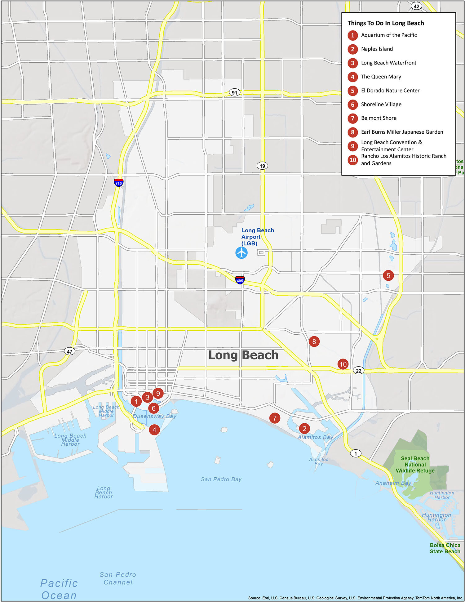
Long Beach, California is the perfect destination for an unforgettable vacation. From its iconic waterfront, to its Aquarium of the Pacific and Queen Mary, there are plenty of amazing attractions to explore. You can also enjoy the beautiful beach city’s nature centers, gardens, and more. So plan your next trip to Long Beach and get ready for an amazing vacation!
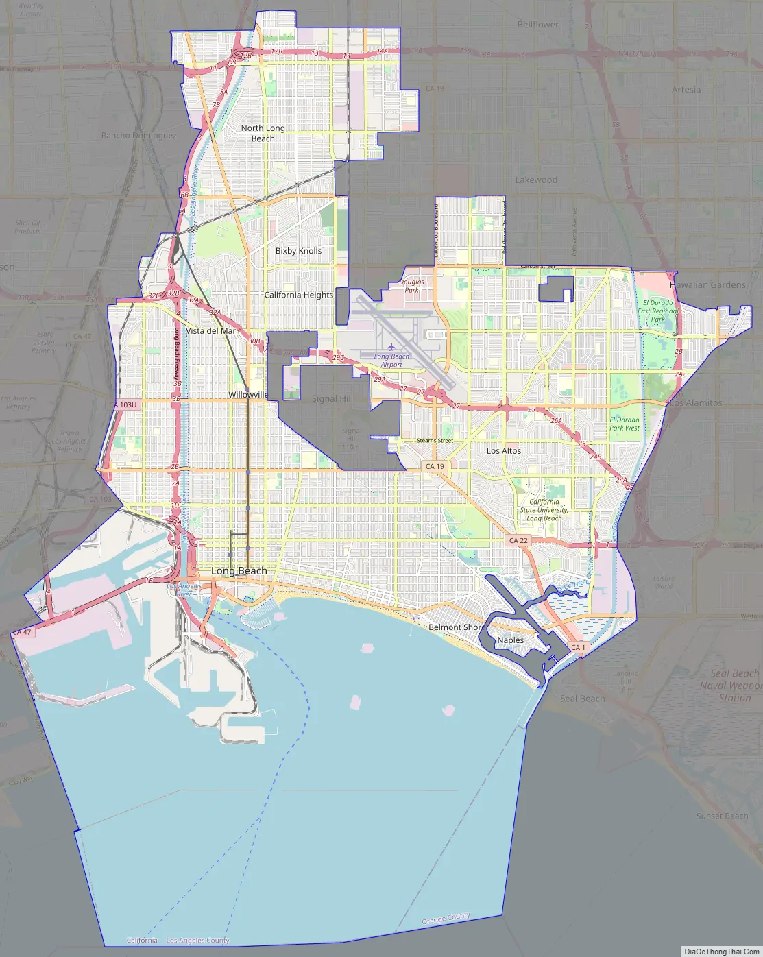
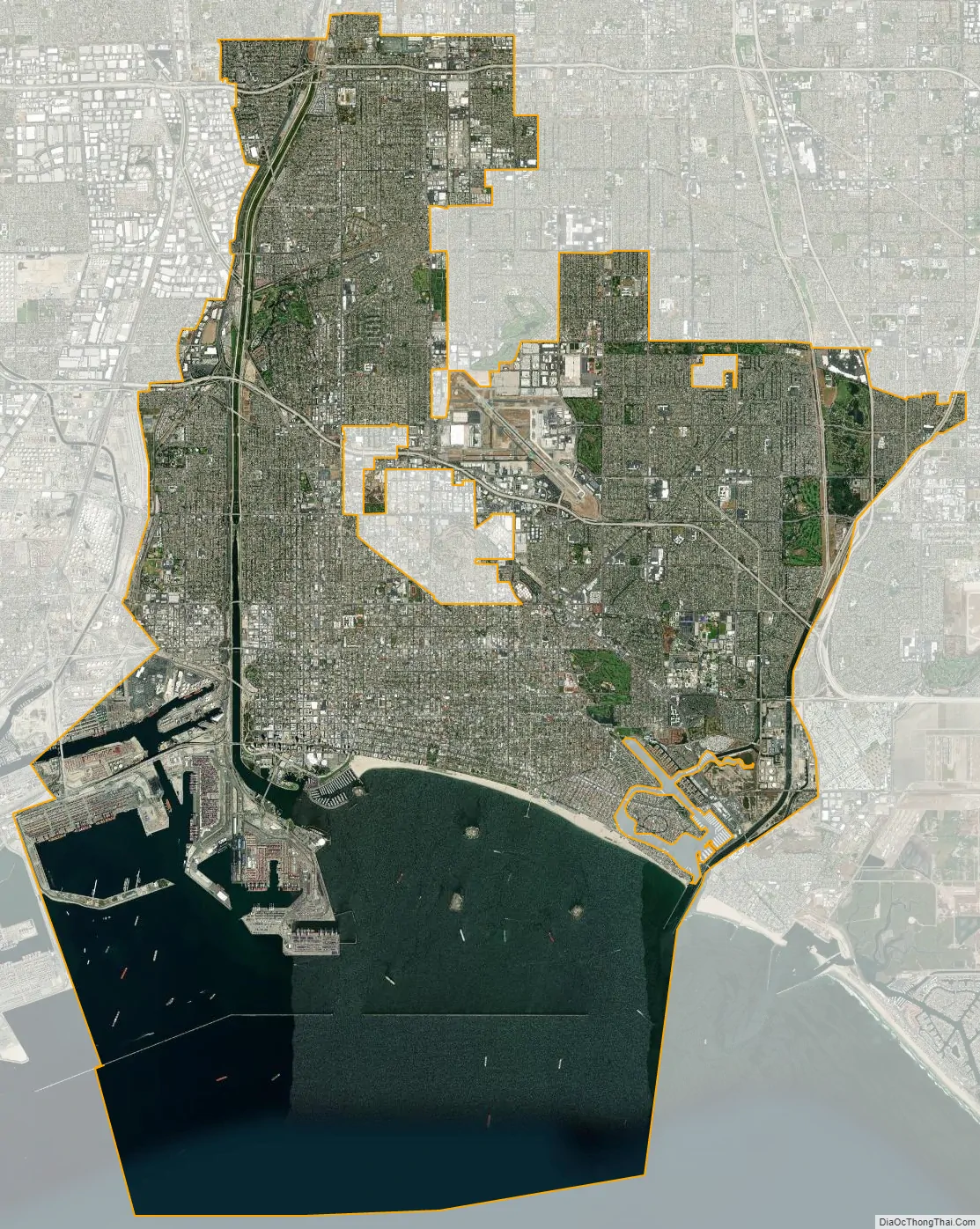
Long Beach city Satellite Map
Geography
Long Beach is about 21 miles (34 km) south of downtown Los Angeles. According to the United States Census Bureau, the city has a total area of 51.437 square miles (133.2 km), of which 50.293 square miles (130.3 km) is land and 1.144 square miles (2.96 km) (2.22%) is water. Long Beach completely surrounds the city of Signal Hill.
Neighborhoods
Long Beach is composed of many different neighborhoods. Some neighborhoods are named after thoroughfares, while others are named for nearby parks, schools, or city features.
Climate
Long Beach has a climate that can either be described as a hot semi-arid climate or a hot-summer Mediterranean climate. In general, the city features hot summers and mild to warm winters with occasional rainfall. Days in Long Beach are mostly sunny, as in Southern California in general. Temperatures recorded at the weather station at the Long Beach Airport, 4.0 miles (6.4 km) inland from the ocean, range more greatly than those along the immediate coast. During the summer months, low clouds and fog occur frequently, developing overnight and blanketing the area on many mornings. This fog usually clears by the afternoon, and a westerly sea breeze often develops, keeping temperatures mild. Heat and high humidity can sometimes coincide in summer, which may cause discomfort due to the heat index.
Long Beach’s location directly east of the Palos Verdes Peninsula, paired with its south facing coastline, results in the city sometimes experiencing different weather patterns than the Los Angeles metropolitan area coastal communities to the northwest and southeast of Long Beach, which largely have west facing coastlines. The 1200 ft Palos Verdes hills block west to east airflow and a significant amount of the coastal moisture that marks other coastal cities, such as Manhattan Beach, Santa Monica, and Newport Beach.
As in most locations in Southern California, most rainfall in Long Beach occurs during the winter months. Storms can bring heavy rainfall.
Environment
Long Beach suffers from some of the worst air pollution in the entire United States. Most of the city is in proximity to the twin ports of Los Angeles and Long Beach, and the prevailing westerly-to-west-south-westerly winds bring a large portion of the twin ports’ air pollution directly into Long Beach before dispersing it northward then eastward. Heavy pollution sources at the ports include the ships themselves, which burn high-sulfur, high-soot-producing bunker fuel to maintain internal electrical power while docked, as well as heavy diesel pollution from drayage trucks at the ports, and short-haul tractor-trailer trucks ferrying cargo from the ports to inland warehousing, rail yards, and shipping centers. Long-term average levels of toxic air pollutants (and the corresponding carcinogenic risk they create) can be two to three times higher in and around Long Beach, and in downwind areas to the east, than in other parts of the Los Angeles metropolitan area, such as the Westside, San Fernando Valley, or San Gabriel Valley. While overall regional pollution in the Los Angeles metropolitan area has declined in the last decade, pollution levels remain dangerously high in much of Long Beach due to the port pollution, with diesel exhaust from ships, trains, and trucks as the largest sources.
Additionally, Long Beach is directly downwind of several of the South Bay oil refineries. Any refinery process or chemical upset that results in the atmospheric release of refinery by-products (commonly sulfur dioxide) will usually impact air quality in Long Beach due to the west-south-westerly prevailing wind.
Similarly, the water quality in the Long Beach portion of San Pedro Bay, which is enclosed by the Federal Breakwater, commonly ranks among the poorest on the entire West Coast during rainy periods. Long Beach beaches average a D or F grade on beach water quality during rainy periods in the Beach Report Card published by Heal the Bay. However, during dry periods the water may have an A or B rating in the same reports. The Los Angeles River discharges directly into the Long Beach side of San Pedro Bay, meaning a large portion of all the urban runoff from the entire Los Angeles metropolitan area pours directly into the harbor water. This runoff contains most of the debris, garbage, chemical pollutants, and biological pathogens washed into storm drains in every upstream city each time it rains. Because the breakwater prevents tidal flushing and wave action, these pollutants build up in the harbor. The water enclosed by the breakwater, along most of the city’s beaches, can be subject to red tides due to this stagnation as well. Because of these factors, the water in Long Beach is sometimes unsafe for swimming, up to weeks each year.
The area that is now Long Beach historically included several ecological communities, with coastal scrub dominating. A handful of the native plants of the region can still be found in the city. These include California buckwheat (Eriogonum fasciculatum), California sagebrush (Artemisia californica), and California poppy (Eschscholzia californica). Some stands of coast live oak (Quercus agrifolia) still remain in the El Dorado Nature Center. California fan palm (Washingtonia filifera), a plant that is native further inland, was introduced to the city as a garden ornamental and is now naturalized. Some indigenous species of birds, mammals, and other wildlife have adapted to development.
Since the arrival of Europeans, many alien species have become naturalized in the area. Introduced plants include yellow mustard, eucalyptus, wild radish, and tumbleweed. Such plants now far outnumber the indigenous plants and spread rapidly in the city’s vacant lots and oil fields.
The city and its residents have initiatives underway to preserve and reclaim part of its ecological heritage. The RiverLink project has begun to revegetate the Long Beach stretch of the Los Angeles River with indigenous plants. Part of the remaining Pacific Electric right-of-way was cleared of nonnatives, planted with indigenous plants, and made accessible with foot and bike paths. This community open space is now known as The Long Beach Greenbelt and is the focus of continuing efforts in restoration and community education.
The El Dorado Nature Center has changed its original “hands-off” approach and has begun to actively introduce indigenous species. The Los Cerritos Wetlands Study Group, state government agencies, and grassroots groups are collaborating on a plan to preserve Long Beach’s last remaining wetlands. Long Beach is the first city in California to join the ‘EcoZone’ Program, intended to measurably improve environmental conditions through public-private partnerships. Such projects seek to reduce pollution, restore native habitat, and provide green areas for the city’s residents to enjoy.
Other places in Long Beach to see natural areas include Bluff Park (coastal bluffs), the Golden Shore Marine Biological Reserve, the Jack Dunster Marine Reserve, Shoreline Park, and DeForest Park.
Long Beach led Southern California in parks access, size and spending, ranking 16th among a survey of 75 large U.S. cities, with Los Angeles and Anaheim tied for 51st and Santa Ana 69th, according to a study released by a national conservation group.
See also
Map of California State and its subdivision:- Alameda
- Alpine
- Amador
- Butte
- Calaveras
- Colusa
- Contra Costa
- Del Norte
- El Dorado
- Fresno
- Glenn
- Humboldt
- Imperial
- Inyo
- Kern
- Kings
- Lake
- Lassen
- Los Angeles
- Madera
- Marin
- Mariposa
- Mendocino
- Merced
- Modoc
- Mono
- Monterey
- Napa
- Nevada
- Orange
- Placer
- Plumas
- Riverside
- Sacramento
- San Benito
- San Bernardino
- San Diego
- San Francisco
- San Joaquin
- San Luis Obispo
- San Mateo
- Santa Barbara
- Santa Clara
- Santa Cruz
- Shasta
- Sierra
- Siskiyou
- Solano
- Sonoma
- Stanislaus
- Sutter
- Tehama
- Trinity
- Tulare
- Tuolumne
- Ventura
- Yolo
- Yuba
- Alabama
- Alaska
- Arizona
- Arkansas
- California
- Colorado
- Connecticut
- Delaware
- District of Columbia
- Florida
- Georgia
- Hawaii
- Idaho
- Illinois
- Indiana
- Iowa
- Kansas
- Kentucky
- Louisiana
- Maine
- Maryland
- Massachusetts
- Michigan
- Minnesota
- Mississippi
- Missouri
- Montana
- Nebraska
- Nevada
- New Hampshire
- New Jersey
- New Mexico
- New York
- North Carolina
- North Dakota
- Ohio
- Oklahoma
- Oregon
- Pennsylvania
- Rhode Island
- South Carolina
- South Dakota
- Tennessee
- Texas
- Utah
- Vermont
- Virginia
- Washington
- West Virginia
- Wisconsin
- Wyoming


