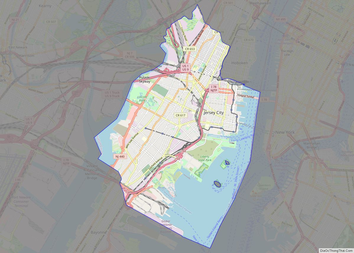
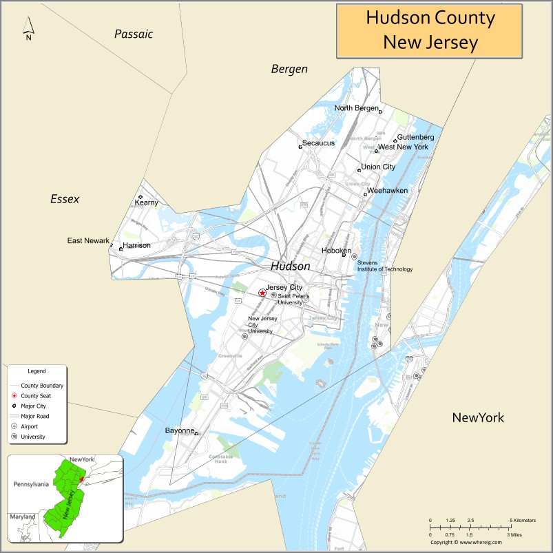
Hudson County is the smallest and most densely populated county in the U.S. state of New Jersey. It lies west of the lower Hudson River, which was named for Henry Hudson, the sea captain who explored the area in 1609. Part of New Jersey’s Gateway Region in the New York metropolitan area, the county seat is Jersey City, which is the county’s largest city in terms of both population and area, with a 2020 population of 292,449, and which covered 21.08 square miles (54.6 km).
As of the 2020 United States census, the county was the state’s fourth-most-populous and fastest-growing county, with a population of 724,854, its highest decennial count ever and an increase of 90,588 (+14.3%) from the 2010 census count of 634,266, which in turn reflected an increase of 25,291 (+4.2%) from the 2000 census population of 608,975.
Home to 15,693 residents per square mile (6,130/km2) in 2020 and covering 46.19 square miles (119.6 km) of land, Hudson County is New Jersey’s geographically smallest and most densely populated county. Hudson County shares extensive mass transit connections with Manhattan, located across the Hudson River, as well as with most of Northern and Central New Jersey. The county is part of the North Jersey region.
| Name: | Hudson County |
|---|---|
| FIPS code: | 34-017 |
| State: | New Jersey |
| Founded: | 1840 |
| Named for: | Henry Hudson |
| Seat: | Jersey City |
| Largest city: | Jersey City (population and area) |
| Total Area: | 62.31 sq mi (161.4 km²) |
| Land Area: | 46.19 sq mi (119.6 km²) |
| Total Population: | 724,854 |
| Population Density: | 15,691.5/sq mi (6,058.5/km²) |
| Website: | www.hudsoncountynj.org |
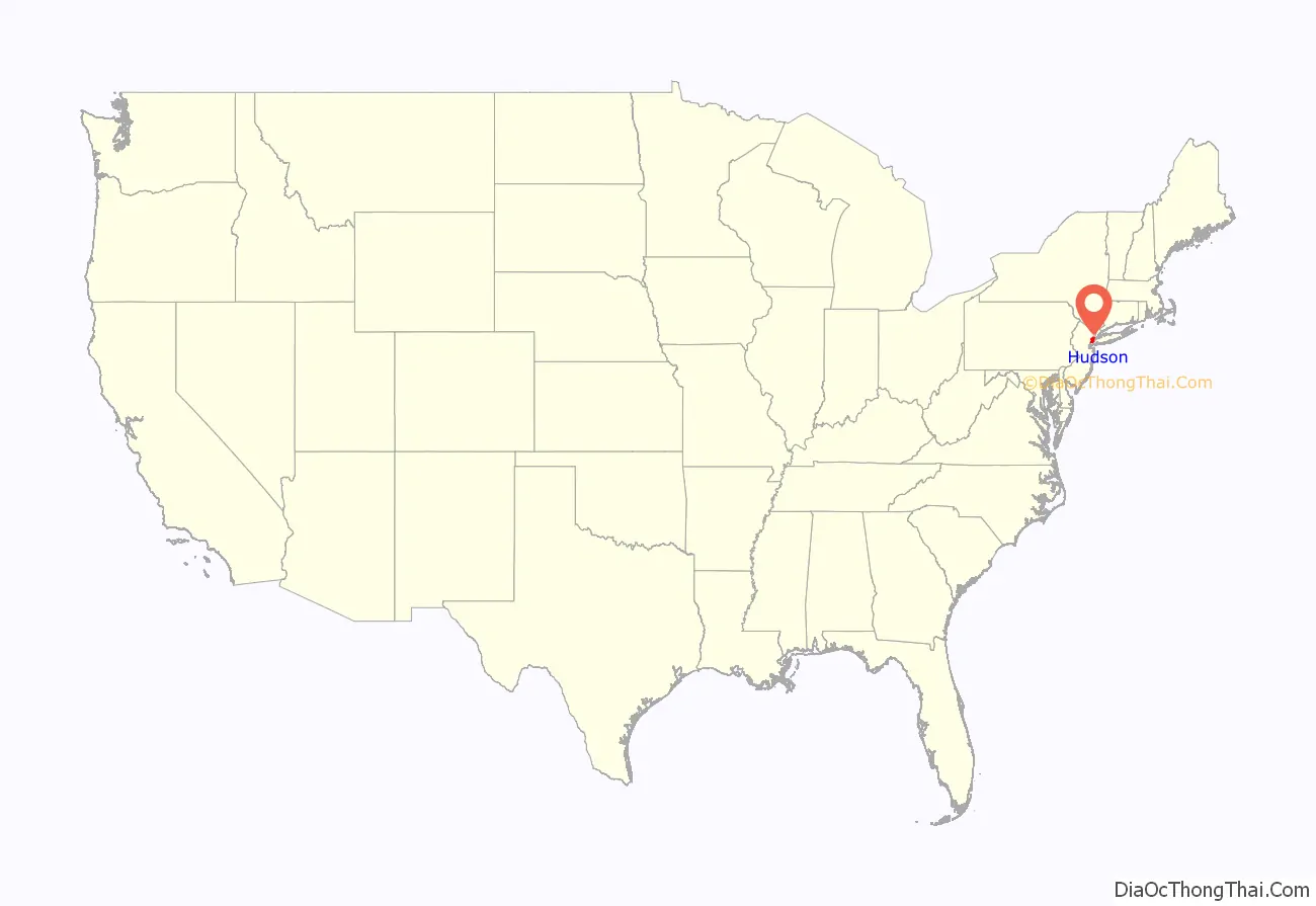
Hudson County location map. Where is Hudson County?
History
The Lenape and New Netherland
At the time of European contact in the 17th century, Hudson County was the territory of the Lenape (or Lenni-Lenape), namely the bands (or family groups) known as the Hackensack, the Tappan, the Raritan, and the Manhattan. They were a seasonally migrational people who practiced small-scale agriculture (companion planting) augmented by hunting and gathering which likely, given the topography of the area, included much (shell) fishing and trapping. These groups had early and frequent trading contact with Europeans. Their Algonquian language can still be inferred in many local place names such as Communipaw, Harsimus, Hackensack, Hoboken, Weehawken, Secaucus, and Pamrapo.
Henry Hudson, for whom the county and river on which it sits are named, established a claim for the area in 1609 when anchoring his ship the Halve Maen (Half Moon) at Harsimus Cove and Weehawken Cove. The west bank of the North River (as it was called) and the cliffs, hills, and marshlands abutting and beyond it, were settled by Europeans (Dutch, Flemish, Walloon, Huguenot) from the Lowlands around the same time as New Amsterdam. In 1630, Michael Pauw received a land patent, or patroonship and purchased the land between the Hudson and Hackensack Rivers, giving it the Latin-ized form of his name, Pavonia. He failed to settle the area and was forced to return his holdings to the Dutch West India Company. Homesteads were established at Communipaw (1633), Harsimus (1634), Paulus Hook (1638) and Hoebuck (1643). Relations were tenuous with the Lenape, and eventually led to Kieft’s War, which began as a slaughter by the Dutch at Communipaw and is considered to be one of the first genocides of Native Americans by Europeans. A series of raids and reprisals across the province lasted two years, and ended in an uneasy truce. Other homesteads were established at Constable Hook (1646), Awiehaken (1647), and other lands at Achter Col on Bergen Neck. In 1658, Director-General Peter Stuyvesant of New Netherland negotiated a deal with the Lenape to re-purchase the area named Bergen, “by the great rock above Wiehacken,” including the whole peninsula from Sikakes south to Bergen Point/Constable Hook. In 1661, a charter was granted the new village/garrison at the site of present-day Bergen Square, establishing what is considered to be the oldest self-governing municipality in New Jersey. The British gained control of the area in 1664, and the Dutch finally ceded formal control of province to the English in 1674.
The British and early America
By 1675, the Treaty of Westminster finalized the transfer and the area became part of the British colony of East Jersey, in the administrative district of Bergen Township. The county’s seat was transferred to Hackensack in 1709, after Bergen County was expanded west. Small villages and farms supplied the burgeoning city of New York, across the river, notably with oysters from the vast beds in the Upper New York Bay, and fresh produce, sold at Weehawken Street, in Manhattan. During the American Revolutionary War the area was under British control which included garrisons at Bulls Ferry and the fort at Bergen Neck. Colonialist troops used the heights to observe enemy movements. The Battle of Paulus Hook, a surprise raid on a British fortification in 1779, was seen as a victory and morale booster for revolutionary forces. Many downtown Jersey City streets bear the name of military figures Mercer, Greene, Wayne, and Varick among them. Weehawken became notorious for duels, including the nation’s most famous between Alexander Hamilton and Aaron Burr in 1804. Border conflicts for control of the waterfront with New York (which claimed jurisdiction to the high water line and the granting of ferry concessions) restricted development though some urbanization took place in at Paulus Hook and Hoboken, which became a vacation spot for well-off New Yorkers. The Morris Canal, early steam railroads, and the development of the harbor stimulated further growth. In September 1840, Hudson County was created by separation from Bergen County and annexation of some Essex County lands, namely New Barbadoes Neck. During the 19th century, Hudson played an integral role in the Underground Railroad, with four routes converging in Jersey City.
Boundaries
Most of Hudson County, apart from West Hudson, was part of Bergen Township, which dates back to 1661 and was formally created by an act of the New Jersey Legislature on February 21, 1798, as one of the first group of 104 townships formed in New Jersey, while the area was still a part of Bergen County. As originally constituted, Bergen Township included the area between the Hudson River on the east, the Hackensack River to the west, south to Constable Hook/Bergen Point and north to the present-day Hudson-Bergen border. For the next 127 years civic borders within the county took many forms, until they were finalized with the creation of Union City in 1925.
The City of Jersey was incorporated by an act of the New Jersey Legislature on January 28, 1820, from portions of Bergen Township. The city was reincorporated on January 23, 1829, and again on February 22, 1838, at which time it became completely independent of Bergen Township and was given its present name. On February 22, 1840, it became part of the newly created Hudson County. As Jersey City grew, several neighboring communities were annexed: Van Vorst Township (March 18, 1851), Bergen City and Hudson City (both on May 2, 1870), and Greenville Township (February 4, 1873).
North Bergen was incorporated as a township on April 10, 1843, by an act of the New Jersey Legislature, from Bergen Township. Portions of the township have been taken to form Hoboken Township (April 9, 1849, now the City of Hoboken), Hudson Town (April 12, 1852, later part of Hudson City), Hudson City (April 11, 1855, later annexed by Jersey City), Guttenberg (formed within the township on March 9, 1859, and set off as an independent municipality on April 1, 1878), Weehawken (March 15, 1859), Union Township and West Hoboken Township (both created on February 28, 1861), Union Hill town (March 29, 1864) and Secaucus (March 12, 1900).
Hoboken was established in 1804, and formed as a township on April 9, 1849, from portions of North Bergen Township and incorporated as a full-fledged city, and in a referendum held on March 29, 1855, ratified an Act of the New Jersey Legislature signed the previous day, and the City of Hoboken was born.
Weehawken was formed as a township by an act of the New Jersey Legislature on March 15, 1859, from portions of Hoboken and North Bergen. A portion of the township was ceded to Hoboken in 1874. Additional territory was annexed in 1879 from West Hoboken.
West New York was incorporated as a town by an act of the New Jersey Legislature on July 8, 1898, replacing Union Township, based on the results of a referendum held three days earlier.
Kearny was originally formed as a township by an act of the New Jersey Legislature on April 8, 1867, from portions of Harrison Township. Portions of the township were taken on July 3, 1895, to form East Newark. Kearny was incorporated as a town on January 19, 1899, based on the results of a referendum held two days earlier.
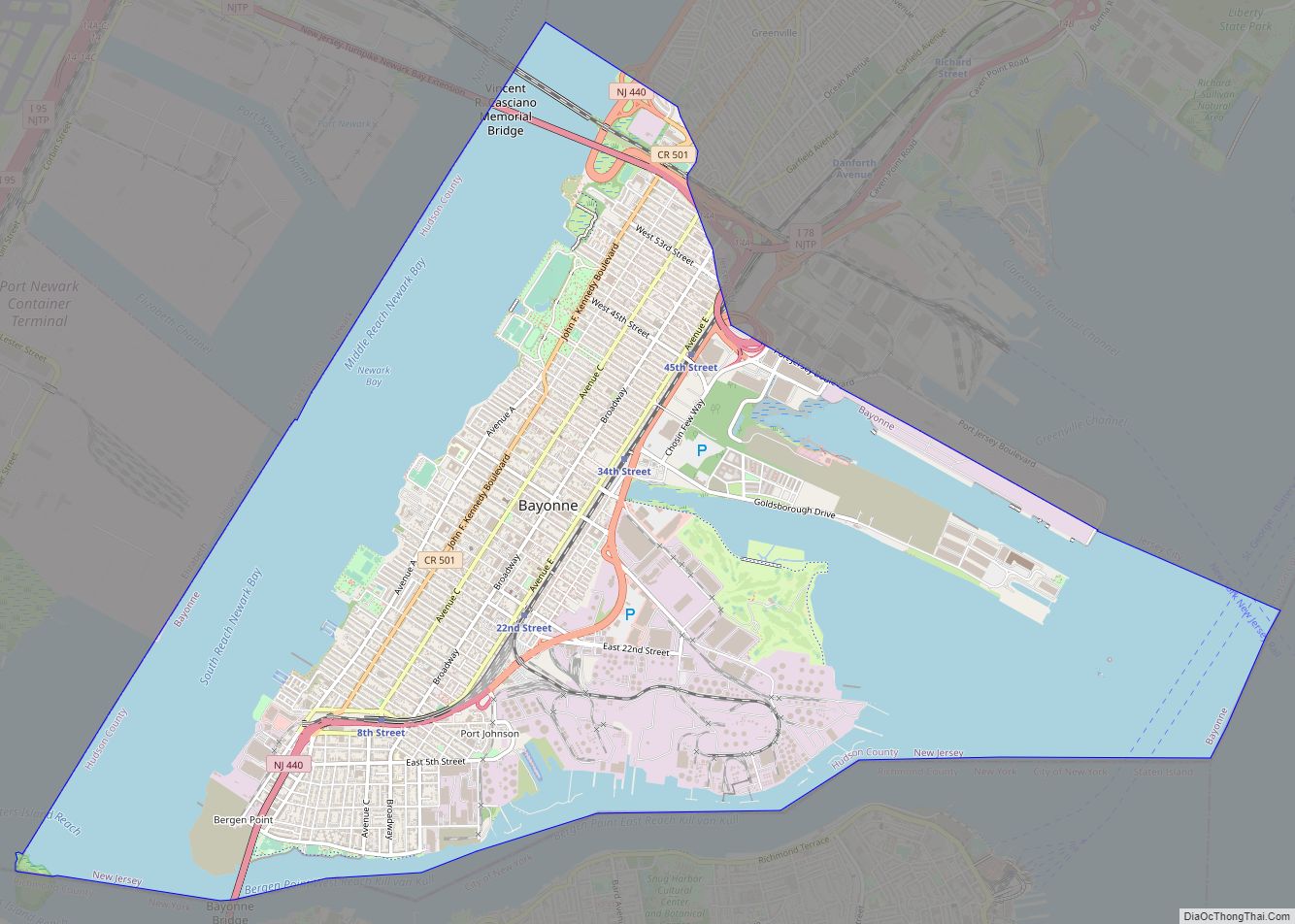
Bayonne was originally formed as a township on April 1, 1861, from portions of Bergen Township. Bayonne was reincorporated as a city by an act of the New Jersey Legislature on March 10, 1869, replacing Bayonne Township, subject to the results of a referendum held nine days later.
Soon after the Civil War the idea of uniting all of the town of Hudson County in one municipality of Jersey City began to gain favor. In 1868 a bill for submitting the question of consolidation of all of Hudson County to the voters was presented to the Board of Chosen Freeholders (now known as the Board of County Commissioners). The bill did not include the western towns of Harrison and Kearny but included all towns east of the Hackensack River.
The bill was approved by the State legislature on April 2, 1869 and the special election was scheduled for October 5, 1869. An element of the bill provided that only contiguous towns could be consolidated. The results of the election were as follows:
While a majority of the voters approved the merger, only Jersey City, Hudson and Bergen could be consolidated since they were the only contiguous approving towns. Both the Town of Union and Union Township could not be included due to the dissenting vote of West Hoboken which lay between them and Hudson City. On March 17, 1870, Jersey City, Hudson City, and Bergen merged into Jersey City. Only three years later the present outline of Jersey City was completed when Greenville agreed to merge into the Greater Jersey City.
Union City was incorporated as a city by an act of the New Jersey Legislature on January 1, 1925, replacing both Union Hill and West Hoboken Township.
Urbanization and immigration
During the latter half of the 19th and early part of the 20th centuries, Hudson experienced intense industrial, commercial and residential growth. Construction, first of ports, and later railroad terminals, in Jersey City, Bayonne, Hoboken, and Weehawken (which significantly altered the shoreline with landfill) fueled much of the development. European immigration, notably German-language speakers and Irish (many fleeing famine) initiated a population boom that would last for several decades.
Neighborhoods grew as farms, estates, and other holdings were sub-divided for housing, civic and religious architecture. Streets (some with trolley lines) were laid out. Stevens Institute of Technology and Saint Peter’s University were established.
Before the opening, in 1910, of the Pennsylvania Railroad’s North River Tunnels under the Hudson, trains terminated on the west bank of the river, requiring passengers and cargo to travel by ferry or barge to New York. Transfer to the Hudson and Manhattan Railroad tubes (now PATH) became possible upon its opening in 1908. Hoboken Terminal, a national historic landmark originally built in 1907 by the Delaware, Lackawanna and Western Railroad to replace the previous one, is the only one of five major rail/ferry terminals that once dotted the waterfront still in operation. West Shore Railroad Terminal in Weehawken, Erie Railroad’s Pavonia Terminal and Pennsylvania Railroad’s Exchange Place in Jersey City were all razed.
Central Railroad of New Jersey’s Communipaw Terminal, across a small strait from Ellis Island and the Statue of Liberty, played a crucial role in the massive immigration of the period, with many newly arrived departing the station to embark on their lives in America. Many, though, decided to stay, taking jobs on the docks, the railroads, the factories, the refineries, and in the sweatshops and skyscrapers of Manhattan. Many manufacturers, whose names read as a “Who’s Who” in American industry established a presence, including Colgate, Dixon Ticonderoga, Maxwell House, Standard Oil, and Bethlehem Steel.
North Hudson, particularly Union City became the schiffli “embroidery capital of America”. The industry included businesses that provided embroidery machines and parts, fabrics, thread, embroidery designs, dying, chemical lace etching, and bleaching. There were hundreds of small shops, each with one or a few machines, producing a wide array of products. Finished embroidery supplied the garment and home goods industries.
Secaucus boasted numerous pig farms and rendering plants. It was during this period that much of the housing stock, namely one and two family homes and low-rise apartment buildings, was built; municipal boundaries finalized, neighborhoods established. Commercial corridors such as Bergenline, Central, Newark and Ocean Avenues came into prominence. Journal Square became a business, shopping, and entertainment mecca, home to The Jersey Journal, after which it is named, and movie palaces such as Loew’s Jersey Theater and The Stanley.
World Wars and New Deal
Upon entry to World War I, the U.S. government took over control of the Hamburg-American Line piers in Hoboken under eminent domain, and Hudson became the major point of embarkation for more than three million soldiers, known as “doughboys”. In 1916, an act of sabotage literally and figuratively shook the region when German agents set off bombs at the munitions depot in New York Bay at Black Tom. The fore-runner of Port Authority of New York and New Jersey was established on April 30, 1921. Huge transportation projects opened between the wars: The Holland Tunnel in 1927, The Bayonne Bridge in 1931, and The Lincoln Tunnel in 1937, allowing vehicular travel between New Jersey and New York City to bypass the waterfront. Hackensack River crossings, notably the Pulaski Skyway, were also built. What was to become New Jersey City University opened. Major Works Progress Administration projects included construction of stadiums in Jersey City and Union City. Both were named for President Franklin D. Roosevelt, who attended the opening of the largest project of them all, The Jersey City Medical Center, a massive complex built in the Art Deco Style. During this era the “Hudson County Democratic Machine”, known for its cronyism and corruption, with Jersey City mayor Frank Hague at its head was at its most powerful. Industries in Hudson were crucial to the war effort during WWII, including the manufacture PT boats by Elco in Bayonne. Military Ocean Terminal at Bayonne (MOTBY) was opened in 1942 as a U.S. military base and remained in operation until 1999.
Post-war years
After the war maritime and manufacturing industries still dominated the local economy, and union membership provided guarantees of good pay packages. Though some returning servicemen took advantage of GI housing bills and moved to close by suburbs, many with strong ethnic and familial ties chose to stay. Baseball legend Jackie Robinson made his minor league debut at Roosevelt Stadium and “broke” the baseball color line. Much of Hudson County experienced the phenomenon of ethnic/economic groups leaving and being replaced by others, as was typical of most urban communities of the New York Bay region. When the big businesses decided to follow them or vice versa, Hudson County’s socioeconomic differences became more profound. Old economic underpinnings disintegrated. Attempts were made to stabilize the population by demolishing so-called slums and build subsidized middle-income housing and the pockets of so-called “good neighborhoods” came in conflict with those that went into decline. Riots occurred in Jersey City in 1964.
Lower property values allowed the next wave of immigrants, many from Latin America, to rent or buy in the county. North Hudson, particularly Union City, saw many émigrés fleeing the Cuban revolution take up residence. Unlike other urban industrial areas of comparable size, age and density, North Hudson did not experience marked urban decay or a crime wave during the late 20th century, its population and economic base remaining basically stable, in part, because of its good housing stock, tightly knit neighborhoods and satisfactory schools systems.
Pre/post-millennium
The county since the mid-1990s has seen much real estate speculation and development and a population increase, as many new residents purchase existing housing stock as well as condominiums in high and mid rise developments, many along the waterfront. What had started as a gentrification in the 1980s became a full-blown “redevelopment” of the area as many suburbanites, transplanted Americans, internationals, and immigrants (most focused on opportunities in NY/NJ region and proximity to Manhattan) began to make the “Jersey” side of the Hudson their home, and the “real-estate boom” of the era encouraged many to seek investment opportunities. The exploitation of certain parts of the waterfront and other brownfields led to commercial development as well, especially along former rail yards. Hudson felt the short- and long-term impact of the destruction of the World Trade Center intensely: its proximity to lower Manhattan made it a place to evacuate to, many residents who worked there lost their jobs (or their lives), and many companies sought office space across the river. Re-zoning, the Hudson-Bergen Light Rail, and New Jersey State land-use policy of transit villages have further spurred construction. Though very urban and with some of the highest residential densities in the United States the Hudson communities have remain fragmented, due in part to New Jersey’s long history of home rule in local government; geographical factors such as Hudson River inlets/canals, the cliffs of the New Jersey Palisades and rail lines; and ethnic/demographic differences in the population. As the county sees more development this traditional perception is challenged.
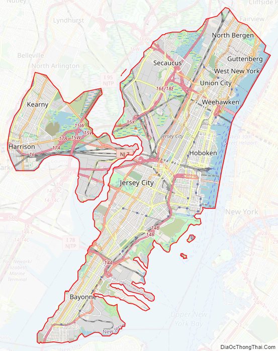
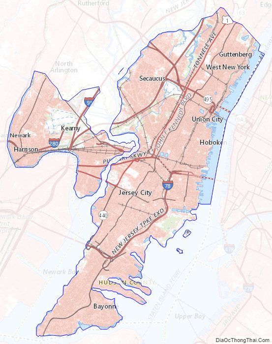
Hudson County Road Map
Geography
Climate
The average temperature of Hudson County is 51.89°F, which is approximately the same as the state average of 51.93°F, and lower than the national average of 54.45°F.
Union City is located on the American east coast, approximately halfway between the Equator and the North Pole, which results in climate that is influenced by wet, dry, hot, and cold airstreams, and highly variable daily weather. Of New Jersey’s five distinct climate regions, Hudson County is located in the Central region, which runs from New York Harbor and the Lower Hudson River to the great bend of the Delaware River near the state capital of Trenton. The high number of urban areas in this region are characterized by a high volume of industry and vehicular traffic that produce large amounts of pollutants. These substances, along with the large amounts of asphalt, brick, and concrete that compose buildings in the area, retain more atmospheric heat, which make it a regularly warmer “heat island” than surrounding suburban and rural areas. The northern border of the Central Zone is often the boundary between freezing and non-freezing precipitation in the winter, and between comfortable and comfortable sleeping conditions in the summer.
Hudson County experiences precipitation an average of 116 days a year, during which it receives an annual average of 48 inches of rain, compared to the national average of 38, and 26 inches of snow, compared to the national average of 28. The summer high temperature in July is about 86 degrees, and its winter low in January is 25. On average, there are 219 sunny days per year in the county, compared with the national average of 205.
Average temperatures in the county seat of Jersey City have ranged from a low of 27 °F (−3 °C) in January to a high of 84 °F (29 °C) in July, although a record low of −15 °F (−26 °C) was recorded in February 1934 and a record high of 106 °F (41 °C) was recorded in July 1936. Average monthly precipitation ranged from 3.21 inches (82 mm) in February to 4.60 inches (117 mm) in July.
Landforms and borders
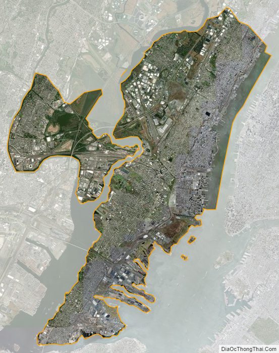
According to the 2010 Census, the county had a total area of 62.31 square miles (161.4 km), including 46.19 square miles (119.6 km) of land (74.1%) and 16.12 square miles (41.8 km) of water (25.9%). Based on land area, it is the smallest of New Jersey’s 21 counties, less than half the size of the next smallest (Union County) and the eighth-smallest of all counties in the United States.
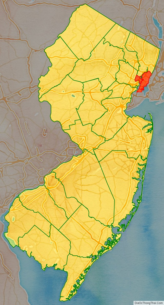
Hudson is located in the heart of New York metropolitan area in northeastern New Jersey. It is bordered by the Hudson River and Upper New York Bay to the east; Kill Van Kull to the south; Newark Bay and the Hackensack River or the Passaic River to the west; its only land border is shared with Bergen County to the north and west.
The topography is marked by the New Jersey Palisades in the north with cliffs overlooking the Hudson to the east and less severe cuesta, or slope, to the west. They gradually level off to the southern peninsula, which is coastal and flat. The western region, around the Hackensack and Passaic is part of the New Jersey Meadowlands. Much of the land along the county’s extensive shoreline and littoral zone was created by land reclamation.
The highest point, at 260 feet (79 m) above sea level, is in West New York; the lowest point is at sea level. North Bergen is the city with the second most hills per square mile in the United States behind San Francisco.
Ellis Island and Liberty Island, opposite Liberty State Park, lie entirely within Hudson County’s waters, which extend to the New York state line. Liberty Island is part of New York. Largely created through land reclamation, Ellis Island covers a land area of 27.5 acres (11.1 ha), with the 2.74-acre (1.11 ha) natural island and contiguous areas comprising a 3.3 acres (1.3 ha) exclave of New York. Shooters Island, in the Kill van Kull, is also shared with New York. Robbins Reef Light sits atop a reef which runs parallel the Bayonne and Jersey City waterfront.
Much of the county lies between the Hackensack and Hudson Rivers on a geographically long narrow peninsula, (sometimes called Bergen Neck), which is a contiguous urban area where it is often difficult to know when one’s crossed a civic boundary. These boundaries and the topography-including many hills and inlets-create very distinct neighborhoods. Kennedy Boulevard runs the entire length of the peninsula. Numerous cuts for rail and vehicular traffic cross Bergen Hill.
Given its proximity to Manhattan, it is sometimes referred to as New York City’s sixth borough.
Hudson County Topographic Map
Hudson County Satellite Map
Hudson County Outline Map