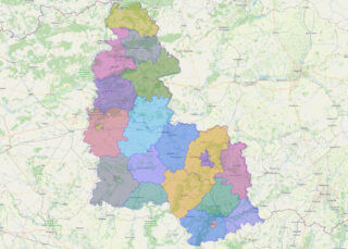
Sumy Oblast (Ukrainian: Сумська́ о́бласть, romanized: Sumska oblast), also known as Sumshchyna (Ukrainian: Су́мщина), is an oblast (province) in northeast Ukraine. The oblast was created in its most recent form, from the merging of raions from Kharkiv Oblast, Chernihiv Oblast, and Poltava Oblast in 1939 by the Presidium of the Supreme Soviet of the Soviet ... Read more
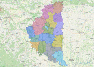
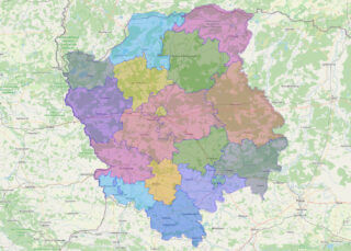
Ternopil Oblast (Ukrainian: Тернопі́льська о́бласть, romanized: Ternopilska oblast; also referred to as Ternopilshchyna, Терно́пільщина, or Ternopillia, Тернопілля) is an oblast (province) of Ukraine. Its administrative center is Ternopil, through which flows the Seret, a tributary of the Dniester. Population: 1,021,713 (2022 est.). One of the natural wonders of the region are its cave complexes. Although ... Read more
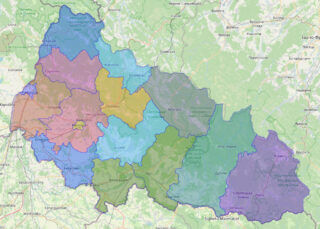
Zakarpattia Oblast (Rusyn and Ukrainian: Закарпатська область, romanized: Zakarpatska oblast; Hungarian: Kárpátalja) is an oblast in western Ukraine, mostly coterminous with the historical region of Carpathian Ruthenia. Its administrative centre is the city of Uzhhorod, Other major cities within the oblast include Mukachevo, Khust, Berehove, and Chop, the last of which is home to railroad ... Read more
Volyn Oblast (Ukrainian: Воли́нська о́бласть, romanized: Volýnsʹka óblastʹ; also referred to as Volyn or Lodomeria) is an oblast (province) in northwestern Ukraine. Its administrative centre is Lutsk. Kovel is the westernmost town and the last station in Ukraine on the rail line running from Kyiv to Warsaw. The population is 1,021,356 (2022 est.) Online subdivision ... Read more
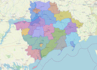
Zaporizhzhia Oblast (Ukrainian: Запорі́зька о́бласть, romanized: Zaporizka oblast), also referred to as Zaporizhzhia (Ukrainian: Запорі́жжя), is an oblast (province) of southeast Ukraine. Its capital is Zaporizhzhia. The oblast covers an area of 27,183 km (10,495 sq mi), and its population is 1,638,462 (2022 est.). This oblast is an important part of Ukraine’s industry and agriculture. Most of the ... Read more
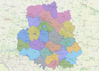
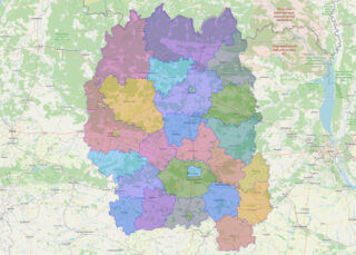
Zhytomyr Oblast (Ukrainian: Жито́мирська о́бласть, romanized: Zhytomyrska oblast), also referred to as Zhytomyrshchyna (Ukrainian: Жито́мирщина) is an oblast (province) of northern Ukraine. The administrative center of the oblast is the city of Zhytomyr. Its population is approximately 1,179,032 (2022 est.). Online subdivision map of Zhytomyr oblast Located in northern-central Ukraine, Zhytomyr Oblast boasts a rich ... Read more
Cherkasy Oblast (Ukrainian: Черка́ська о́бласть, romanized: Cherkaska oblast, pronounced [tʃerˈkɑsʲkɐ ˈɔblɐstʲ]), also referred to as Cherkashchyna (Черка́щина, IPA: [tʃerˈkɑʃtʃɪnɐ]) is an oblast (province) in central Ukraine located along the Dnieper River. The administrative center of the oblast is the city of Cherkasy. The current population of the oblast is 1,160,744 (2022 est.). Online subdivision map of Cherkasy ... Read more
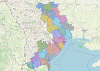
Odesa Oblast (Ukrainian: Оде́ська о́бласть, romanized: Odeska oblast), also referred to as Odeshchyna (Ukrainian: Оде́щина) is an oblast (province) of southwestern Ukraine, located along the northern coast of the Black Sea. Its administrative centre is the city of Odesa (Ukrainian: Одеса). Population: 2,351,382 (2022 est.). The length of coastline (sea-coast and estuaries) reaches 300 km (190 mi), ... Read more
Chernihiv Oblast (Ukrainian: Черні́гівська о́бласть, romanized: Chernihivska oblast), also referred to as Chernihivshchyna (Черні́гівщина), is an oblast (province) in northern Ukraine. The administrative center of the oblast is the city of Chernihiv. Within the oblast are 1,511 settlements. Population: 959,315 (2022 est.). Online subdivision map of Chernihiv oblast Chernihiv oblast is a region located in ... Read more
Poltava Oblast (Ukrainian: Полта́вська о́бласть, romanized: Poltavska oblast; also referred to as Poltavshchyna – Ukrainian: Полта́вщина, literally ‘Poltava Country’) is an oblast (province) of central Ukraine. The administrative center of the oblast is the city of Poltava. Most of its territory is part of the historic Cossack Hetmanate (its southern regions: Poltava, Myrhorod, Lubny, and ... Read more
Chernivtsi Oblast (Ukrainian: Черніве́цька о́бласть, romanized: Chernivetska oblast), also referred to as Chernivechchyna (Ukrainian: Чернівеччина), is an oblast (province) in Western Ukraine, consisting of the northern parts of the regions of Bukovina and Bessarabia. It has an international border with Romania and Moldova. The oblast is the smallest in Ukraine both by area and population. ... Read more