Map of Jamaica

Map of Jamaica

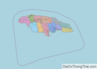
Covering an area of 10,991 sq. km (4,244 sq mi), Jamaica is the 3rd largest island in the Caribbean, after Cuba and Hispaniola. As observed on the physical map of Jaimaica, it is mostly mountainous, with a narrow, discontinuous coastal plain. The island is ringed by numerous bays, small cays and islands, and white-sand beaches stretch for … Read more

Map of Burkina Faso

Map of Burkina Faso

Burkina Faso is a West African landlocked country with an area of 274,200 sq. km. Burkina Faso is located on a massive plateau that is cut deeply by the three main rivers of Black Volta, White Volta, and Red Volta. As visible on the physical map above, these rivers enter Ghana to converge and form … Read more

Map of Albania

Map of Albania

Albania is a sovereing country occupying an area of 28,748 sq. km (11,100 sq mi) in southeast Europe. As observed on the physical map of Albania, the country exhibits significant diversity in topography. The landscape ranges from snow-capped mountains to warm and sunny coastal areas along the Ionian and Adriatic seas. From the broad and swampy coastal … Read more

Map of Mozambique

Map of Mozambique

Mozambique occupies an area of 801,590 sq. km in Southern Africa.  Mozambique is divided into two major topographical regions:To the north of the Zambezi river that runs almost through central Mozambique, a narrow coastline and bordering plateau slope upward into hills and a series of rugged highlands like Angonia Highlands and Lichinga Highlands (as shown … Read more

Map of Malta

Map of Malta

Malta, one of the world’s smallest nations, occupies an area of 316 sq. km in the Mediterranean Sea. As observed on the physical map of Malta, the country is a cluster of small islands. These islands are composed of coralline limestone. The three largest islands in the archipelago are Malta, Comino, and Gozo. Only these … Read more

Map of Palestine

Map of Palestine

Covering an area of 6,020 sq. km, the State of Palestine is a de jure sovereign state, located in Western Asia and comprising of the territories of the West Bank and Gaza Strip. As observed on the map, the coastal lowlands front the Mediterranean Sea. Mount Nabi Yunis – the highest point is located in … Read more

Map of Benin

Map of Benin

Benin is a country in West Africa that encompasses an area of 112,622 sq. km. It has a coastline of 121 km on the Atlantic Ocean to the south.  There is not much variation in elevation in Benin with the average elevation being 200m. The landscape transitions from a narrow and somewhat sandy coastal area … Read more

Map of Mauritius

Map of Mauritius

Mauritius occupies a total area of 2,040 sq. km in the Indian Ocean. It is made up of the main island of Mauritius and several outlying islands like the Ambre Island, Est Island, Cerfs Island, Benitiers Island, etc., as marked on the map.  The island of Mauritius is a volcanic island formed by volcanic activity … Read more

Map of Madagascar

Map of Madagascar

Located off the coast of East Africa in the Indian Ocean, Madagascar is the second-largest island country in the world. It covers an area of t 592,800 sq. kilometers. The country can be divided into three parallel longitudinal physiographic regions. The coastal strip in the east, the central plateau, and the western regions of low … Read more

Map of Mongolia

Map of Mongolia

With an area of 1,564,116 sq. km, Mongolia is the world’s 18th largest country. It is located in East Asia where it is bounded by land on all sides. As observed on the physical map of Mongolia, the country features vast areas of elevated lands including plateaus, mountains, and hills. From the Gobi Desert areas … Read more

Map of Armenia

Map of Armenia

Armenia covers an area of 29,743 sq. km (11,484 sq mi) in Eurasia’s South Caucasus region. It is a landlocked country. As observed on the physical map of Armenia above, the topography of the country is very rugged and mountainous. Nearly the entire land is covered by the Lesser (or Little) Caucasus Mountains. The highest point is Mt. … Read more

Map of Guinea

Map of Guinea

The coastal country of Guinea in West Africa covers an area of 245,857 sq. km.  The country has been divided into four geographic regions. The Lower Guinea or the coastal plain that runs north to south along the coast of the country on the Gulf of Guinea. It features many drowned river valleys or rias … Read more