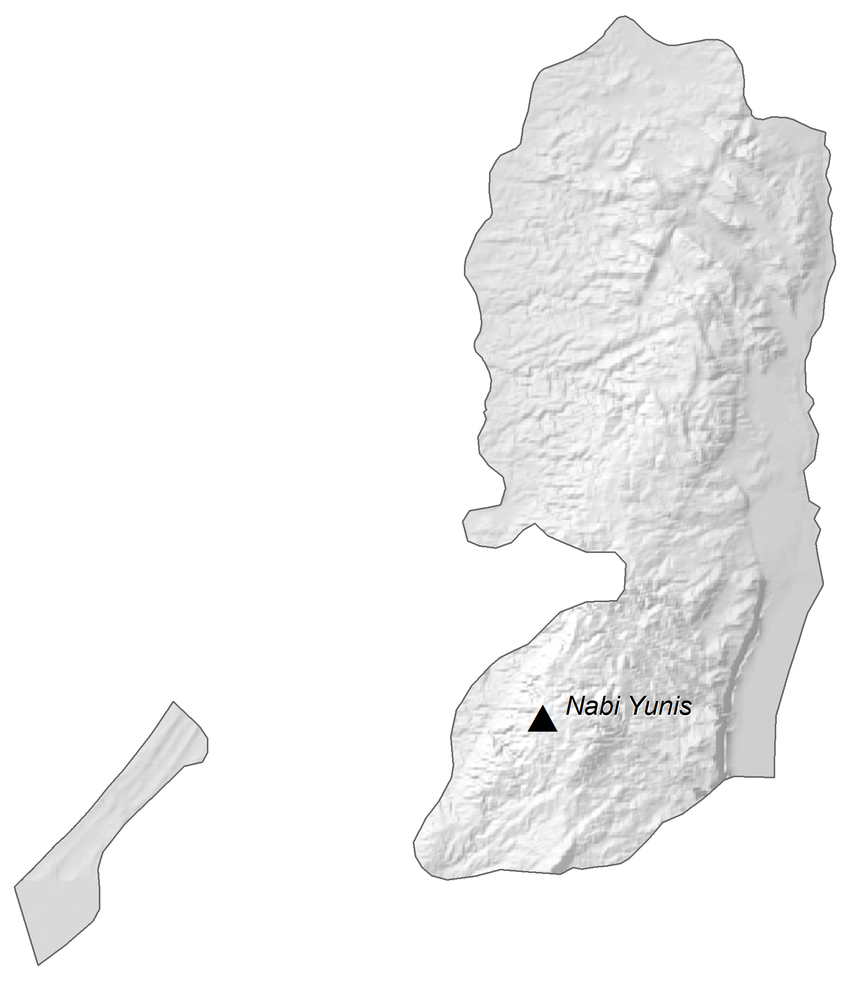
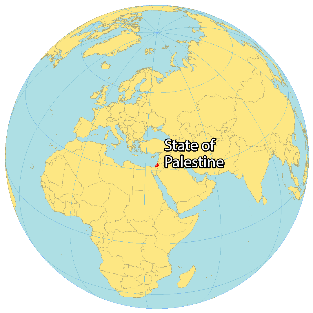
Covering an area of 6,020 sq. km, the State of Palestine is a de jure sovereign state, located in Western Asia and comprising of the territories of the West Bank and Gaza Strip. As observed on the map, the coastal lowlands front the Mediterranean Sea. Mount Nabi Yunis – the highest point is located in the West Bank territory, at an elevation of 3,379ft (1,030m). The lowest point is at the Dead Sea, at (-412m) (-1,352ft).
A wide variety of geographic definitions of Palestine have been used over the centuries, and those definitions have always been emotionally and politically contentious.
On November 15th, 1988, the Palestinian National Council declared independence from the State of Israel.
Currently the “State of Palestine” is officially recognized by the United Nations as a Non-Member Observer State, a status granted on November 29. 2012. The only other geographic entity currently holding this status is the Holy See (Vatican), while Switzerland held the status until 2002.
As of August 2014, 134 nations have officially recognized Palestine as a sovereign state following the Palestinian declaration of independence. Notably, of the G-20 nations,only Argentina, Brazil, China, India, Indonesia, Saudi Arabia, South Africa, and Turkey recognize the declaration of independence. Of the G-8 nations, only Russia officially defines Palestine as a sovereign state.
Many of the historical issues concerning Israelis and Palestinians involve geography and maps. In recent years the fragmented Palestinian Territories are generally located within the Gaza Strip, East Jerusalem and the West Bank.
| Flag: |  |
|---|---|
| Legal Name: | Gaza Strip |
| Largest City: |
Gaza (incl. Ash Shati Camp) (713,621) |
| Official languages: | Arabic |
| Demonym(s): | Palestinian |
| Government: | Unitary semi-presidential republic |
| Legislature: | National Council |
| Total Area: | 360 km² |
| Land Area: | 360 km² |
| Population: | 4,685,306 |
| Density: | 731/km (1,893.3/sq mi) |
| GDP: | $14.62 Billion |
| GDP Per Capita: | $3,198.87 |
| Currency Value: | <p>see entry for the West Bank</p> |
| Driving side: | right |
| Calling code: | +970 |
| Internet TLD: | .ps |
Explore the historic and beautiful State of Palestine with this interactive map. View the cities, towns, highways, lakes, and roads of the Gaza Strip and West Bank regions in stunning satellite imagery and elevation maps. Discover the beauty of Palestine!
Online Interactive Political Map
Click on ![]() to view map in "full screen" mode.
to view map in "full screen" mode.
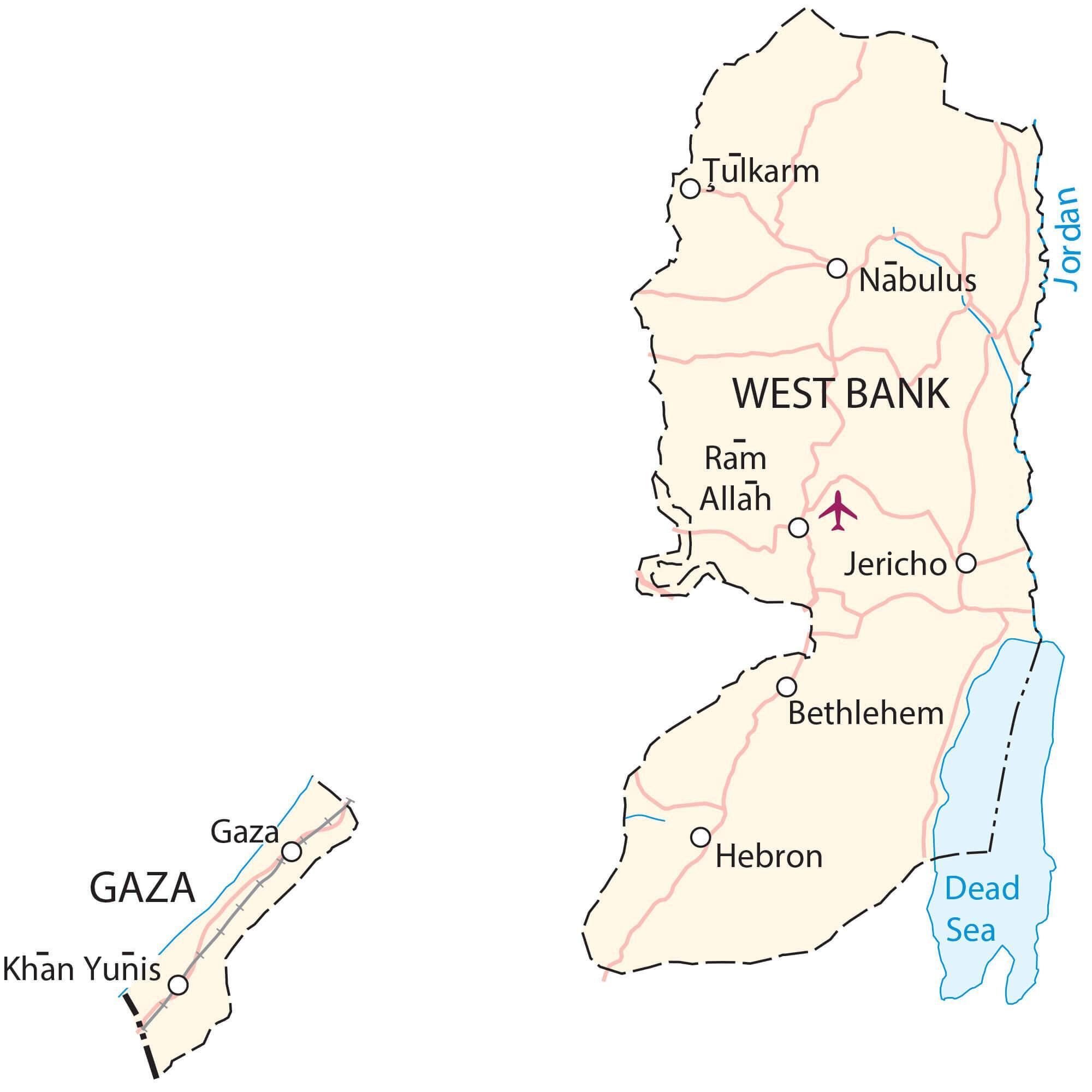
Covering an area of 6,020 sq. km, the State of Palestine is a de jure sovereign state, located in Western Asia and comprising of the territories of the West Bank and Gaza Strip. Located to the north of Jerusalem, in the central part of the West Bank is the city of Ramallah – the current administrative center of Palestine.
Palestine (officially, The State of Palestine) is divided into sixteen administrative divisions. In alphabetical order, these divisions are Bethlehem, Deir Al-Balah, Gaza, Hebron, Jenin, Jericho & Al Aghwar, Jerusalem, Khan Yunis, Nablus, North Gaza, Qalqiliya, Rafah, Ramallah & Al-Bireh, Salfit, Tubas, and Tulkarm.
Location Maps
Where is Palestine?
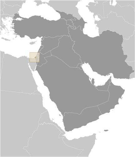
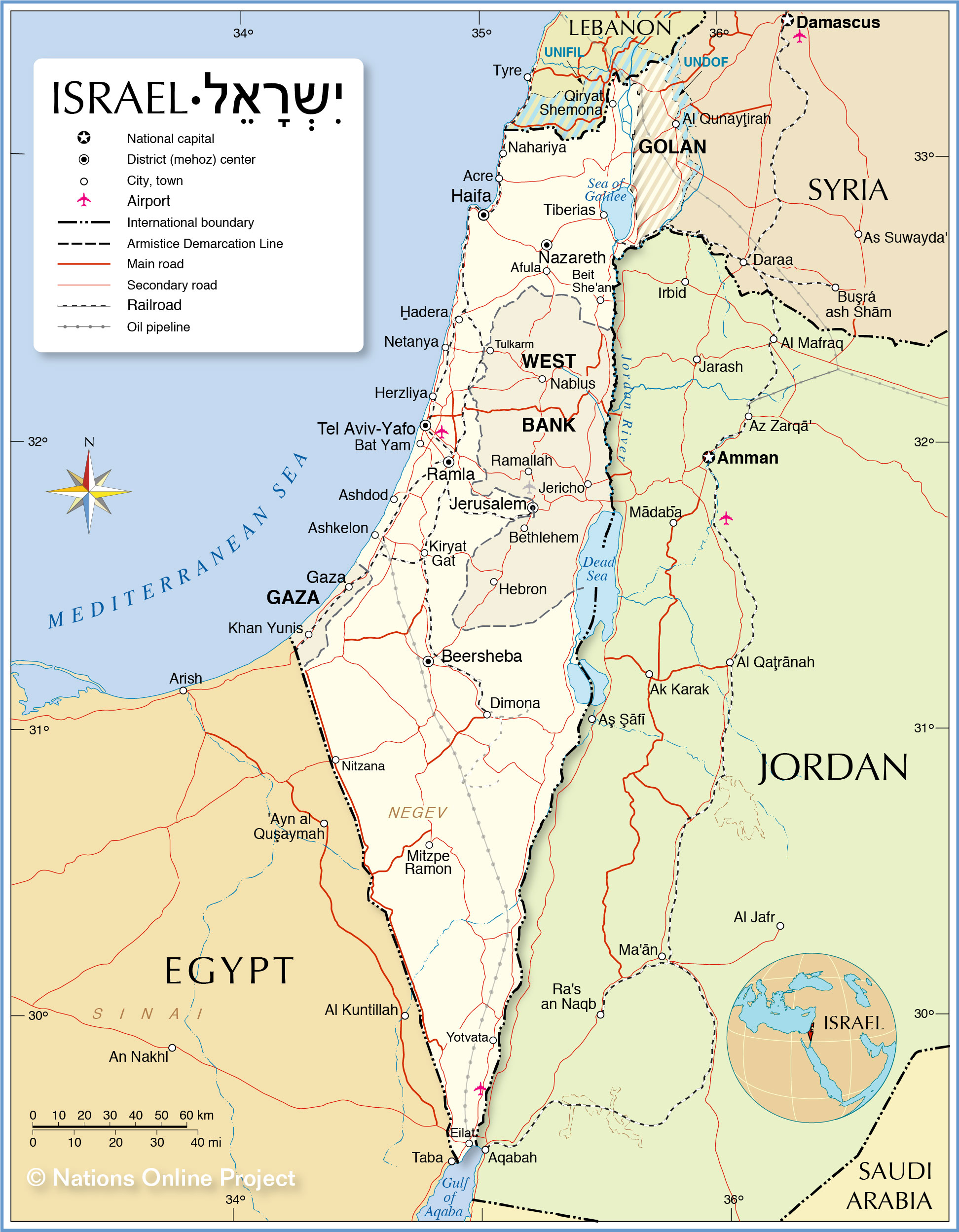
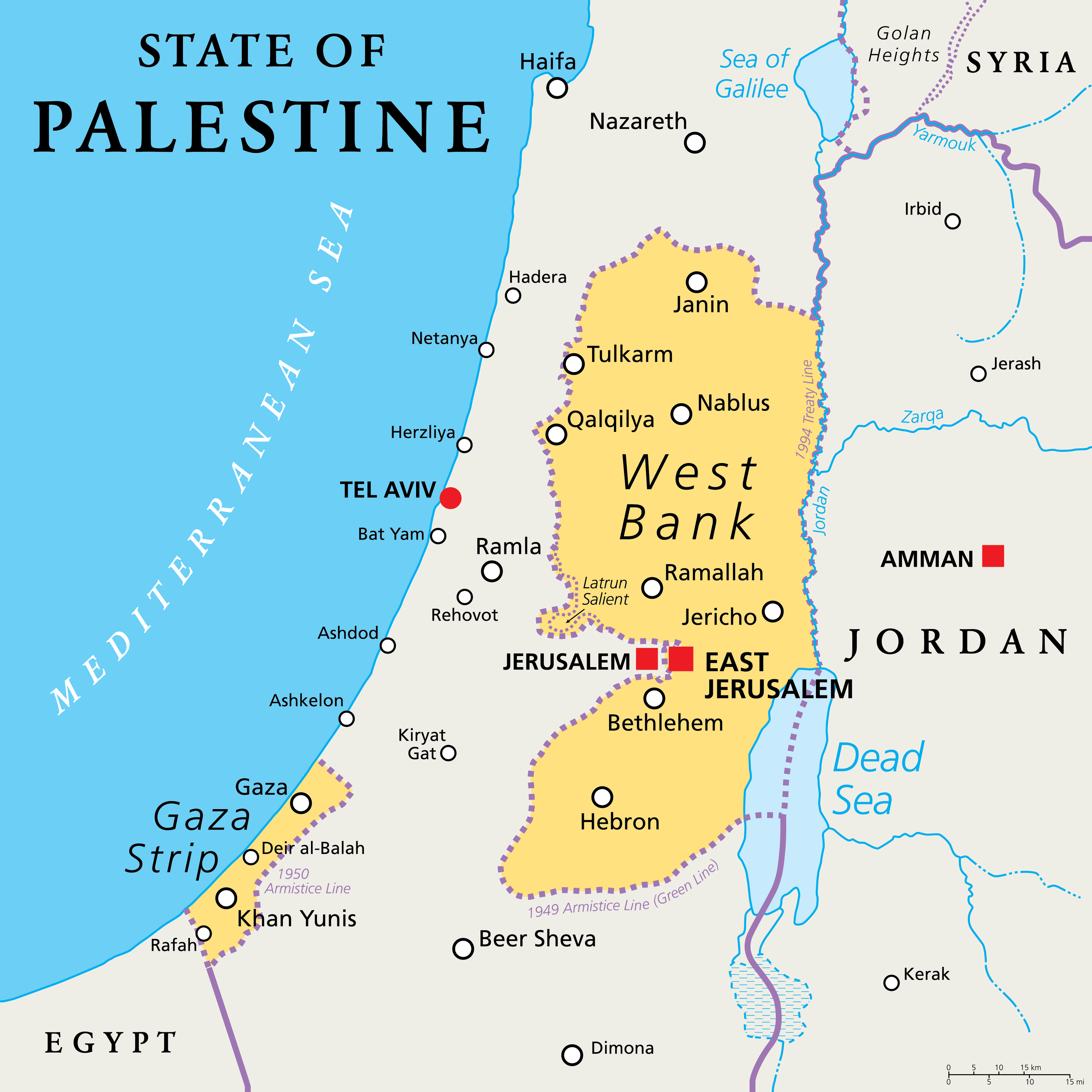
The State of Palestine is made up of two distinct regions – the Gaza Strip and West Bank. Both of these regions are surrounded by Israel, with the Gaza Strip bordered by Egypt to the west, and the West Bank adjacent to Jordan to the east, the Jordan River separating them. The legal status of the State of Palestine is contested from a range of perspectives, and it does not have a capital city. Its main inhabited areas are Gaza, East Jerusalem, Khan Yunis, Ramallah and Jericho.
High Definition Political Map of Palestine
History
In 1947, the UN adopted a partition plan for a two-state solution in the remaining territory of the mandate. The plan was accepted by the Jewish leadership but rejected by the Arab leaders, and Britain refused to implement the plan. On the eve of final British withdrawal, the Jewish Agency for Israel, headed by David Ben-Gurion, declared the establishment of the State of Israel according to the proposed UN plan. The Arab Higher Committee did not declare a state of its own and instead, together with Transjordan, Egypt, and the other members of the Arab League of the time, commenced military action resulting in the 1948 Arab–Israeli War. During the war, Israel gained additional territories that were designated to be part of the Arab state under the UN plan. Egypt occupied the Gaza Strip and Transjordan occupied and then annexed the West Bank. Egypt initially supported the creation of an All-Palestine Government but disbanded it in 1959. Transjordan never recognized it and instead decided to incorporate the West Bank with its own territory to form Jordan. The annexation was ratified in 1950 but was rejected by the international community. The Six-Day War in 1967, when Israel fought against Egypt, Jordan, and Syria, ended with Israel occupying the West Bank and the Gaza Strip, besides other territories.
In 1964, when the West Bank was controlled by Jordan, the Palestine Liberation Organization was established there with the goal to confront Israel. The Palestinian National Charter of the PLO defines the boundaries of Palestine as the whole remaining territory of the mandate, including Israel. Following the Six-Day War, the PLO moved to Jordan, but later relocated to Lebanon in 1971.
The October 1974 Arab League summit designated the PLO as the “sole legitimate representative of the Palestinian people” and reaffirmed “their right to establish an independent state of urgency.” In November 1974, the PLO was recognized as competent on all matters concerning the question of Palestine by the UN General Assembly granting them observer status as a “non-state entity” at the UN. After the 1988 Declaration of Independence, the UN General Assembly officially acknowledged the proclamation and decided to use the designation “Palestine” instead of “Palestine Liberation Organization” in the UN. In spite of this decision, the PLO did not participate at the UN in its capacity of the State of Palestine’s government.
In 1979, through the Camp David Accords, Egypt signaled an end to any claim of its own over the Gaza Strip. In July 1988, Jordan ceded its claims to the West Bank—with the exception of guardianship over Haram al-Sharif—to the PLO. In November 1988, the PLO legislature, while in exile, declared the establishment of the “State of Palestine”. In the month following, it was quickly recognised by many states, including Egypt and Jordan. In the Palestinian Declaration of Independence, the State of Palestine is described as being established on the “Palestinian territory”, without explicitly specifying further. Because of this, some of the countries that recognised the State of Palestine in their statements of recognition refer to the “1967 borders”, thus recognizing as its territory only the occupied Palestinian territory, and not Israel. The UN membership application submitted by the State of Palestine also specified that it is based on the “1967 borders”. During the negotiations of the Oslo Accords, the PLO recognised Israel’s right to exist, and Israel recognised the PLO as representative of the Palestinian people. The 1988 Palestinian Declaration of Independence included a PNC call for multilateral negotiations on the basis of UN Security Council Resolution 242 later known as “the Historic Compromise”, implying acceptance of a two-state solution and no longer questioning the legitimacy of the State of Israel.
After Israel captured and occupied of the West Bank from Jordan and Gaza Strip from Egypt, it began to establish Israeli settlements there. Administration of the Arab population of these territories was performed by the Israeli Civil Administration of the Coordinator of Government Activities in the Territories and by local municipal councils present since before the Israeli takeover. In 1980, Israel decided to freeze elections for these councils and to establish instead Village Leagues, whose officials were under Israeli influence. Later this model became ineffective for both Israel and the Palestinians, and the Village Leagues began to break up, with the last being the Hebron League, dissolved in February 1988.
In 1993, in the Oslo Accords, Israel acknowledged the PLO negotiating team as “representing the Palestinian people”, in return for the PLO recognizing Israel’s right to exist in peace, acceptance of UN Security Council resolutions 242 and 338, and its rejection of “violence and terrorism”. As a result, in 1994 the PLO established the Palestinian National Authority (PNA or PA) territorial administration, that exercises some governmental functions in parts of the West Bank and the Gaza Strip. In 2007, the Hamas takeover of Gaza Strip politically and territorially divided the Palestinians, with Abbas’s Fatah left largely ruling the West Bank and recognized internationally as the official Palestinian Authority, while Hamas secured its control over the Gaza Strip. In April 2011, the Palestinian parties signed an agreement of reconciliation, but its implementation had stalled until a unity government was formed on 2 June 2014.
As envisioned in the Oslo Accords, Israel allowed the PLO to establish interim administrative institutions in the Palestinian territories, which came in the form of the PNA. It was given civilian control in Area B and civilian and security control in Area A, and remained without involvement in Area C. In 2005, following the implementation of Israel’s unilateral disengagement plan, the PNA gained full control of the Gaza Strip with the exception of its borders, airspace, and territorial waters. Following the inter-Palestinian conflict in 2006, Hamas took over control of the Gaza Strip (it already had majority in the PLC), and Fatah took control of the West Bank. From 2007, the Gaza Strip was governed by Hamas, and the West Bank by Fatah.
Physical Map of Palestine
Geography
The areas claimed by the State of Palestine lie in the Southern Levant. The Gaza Strip borders the Mediterranean Sea to the west, Egypt to the south, and Israel to the north and east. The West Bank is bordered by Jordan to the east, and Israel to the north, south, and west. Thus, the two enclaves constituting the area claimed by State of Palestine have no geographical border with one another, being separated by Israel. These areas would constitute the world’s 163rd largest country by land area.
Palestine has a number of environmental issues; issues facing the Gaza Strip include desertification; salination of fresh water; sewage treatment; water-borne diseases; soil degradation; and depletion and contamination of underground water resources. In the West Bank, many of the same issues apply; although fresh water is much more plentiful, access is restricted by the ongoing dispute.
Three terrestrial ecoregions are found in the area: Eastern Mediterranean conifer–sclerophyllous–broadleaf forests, Arabian Desert, and Mesopotamian shrub desert.
Climate
Temperatures in Palestine vary widely. The climate in the West Bank is mostly Mediterranean, slightly cooler at elevated areas compared with the shoreline, west to the area. In the east, the West Bank includes much of the Judean Desert including the western shoreline of the Dead Sea, characterised by dry and hot climate. Gaza has a hot semi-arid climate (Köppen: BSh) with mild winters and dry hot summers. Spring arrives around March–April and the hottest months are July and August, with the average high being 33 °C (91 °F). The coldest month is January with temperatures usually at 7 °C (45 °F). Rain is scarce and generally falls between November and March, with annual precipitation rates approximately at 4.57 inches (116 mm).
Palestine Satellite Map
Elevation Map