Map of Brunei

Map of Brunei

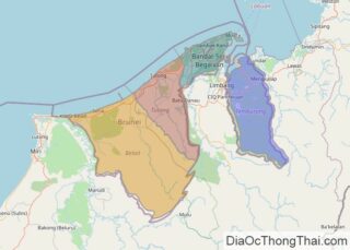
Brunei is a small country that covers an area of 5,765 sq. km (2,226 sq mi) on the island of Borneo. It has a 161 km (100 mi) coastline along the South China Sea. It can be seen on the map above that Brunei is divided into two non-contiguous territories that are separated by the … Read more

Map of Niger

Map of Niger

The landlocked West African country of Niger occupies an area of 1,267,000 sq. km.  As visible on the physical map above, large parts of Niger is covered by the Sahara Desert.  In the north, the Air Mountains punctuate the Sahara desert in a north-south direction with a series of nine massifs. The highest point of … Read more

Map of Bahamas

Map of Bahamas

Covering an area of 13,878 sq. km, The Bahamas (all coral in origin) occupies larger part of Lucayan Archipelago and comprises a group of nearly 700 (atolls) ring-like coral islands, and (cays) small, low islands composed largely of coral or sand. The islands were mostly created by the disintegration of coral reefs and seashells, and … Read more

Map of North Macedonia

Map of North Macedonia

North Macedonia covers an area of 25,713 sq. km in Southeast Europe.  As observed on the physical map of the country above, Macedonia is an elevated plateau of large, rolling hills and deep valleys, completely dissected and surrounded by mountains like the Sar Mountains, Osogovski Mountains, Malesevski Mountains, Nidze Mountains and others. The Dinaric Alps … Read more

Map of Nicaragua

Map of Nicaragua

Nicaragua is a Central American country covering a total area of 130,370 sq. km (50,340 sq. mi) making it the region’s biggest country.  The country can be divided into roughly three physiographic regions, the Pacific lowlands, central highlands, and the Caribbean highlands.  The Pacific lowlands extend about 75 km inland from the coast. As seen … Read more

Map of Namibia

Map of Namibia

Namibia’s extent can be divided into three topographic zones from west to east. The coastal Namib Desert runs along the country’s coast on the Atlantic Ocean. It gives way to the Central Plateau to the west with the Kalahari Desert located further inwards.  The Namib Desert is both rocky and sandy. It has an average … Read more

Map of South Sudan

Map of South Sudan

The East-Central African country of South Sudan covers an area of around 619,745 sq. km. The Nile River system is the country’s dominant physical feature. Most of the rivers of the country drain into the Nile River which leaves the country to enter Sudan and flow further north. The terrain of South Sudan features massive … Read more

Map of Moldova

Map of Moldova

Moldova is a small Eastern European country with an area of 33,846 km2(13,068 sq mi) including the disputed territory of Transnistria. Excluding it, Moldova occupies an area of 29,683 km2(11,461 sq mi). As observed on the physical map of Moldova, the country has a hilly terrain with a subtle slope south toward the Black Sea. … Read more

Map of Chad

Map of Chad

Chad is a landlocked country in North-Central Africa occupying an area of 1,284,000 sq. km.  The map illustrates the country of Chad. In the northern reaches of the country, the Tibesti Mountains dominate the landscape of the surrounding Sahara Desert.  As observed on the map, the Sahel region, on the southern edges of the ever-expanding … Read more

Map of Equatorial Guinea

Map of Equatorial Guinea

As observed on the physical map above, Equatorial Guinea in west-central Africa has two distinct regions, a mainland region, and an insular region. The country has a total land area of 28,051 sq. km.  The mainland of Equatorial Guinea begins on a narrow coastal plain, edged by mangrove swamps. From there, the land rises into … Read more

Map of Republic of the Congo

Map of Republic of the Congo

The Republic of the Congo is located in northern Africa’s western coast with a coastline of 169 km along the Atlantic Ocean. The country occupies an area of 342,000 sq. km. As observed on the physical map above, the country has varying terrain. It includes coastal plains, plateaus, fertile river valleys, and mountains with around … Read more

Map of Rwanda

Map of Rwanda

The landlocked country of Rwanda in the African Great Lakes region of Central/Eastern Africa covers an area of 26,338 sq. km.  Mountains dominate the landscape of western Rwanda. They are part of the Albertine Rift Mountains. The Virunga Mountains to the northwest of the country host the highest peak of Rwanda, Mount Karisimbi (marked on … Read more