Map of Venezuela

Map of Venezuela

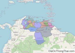
Covering a total area of 916,445 sq.km (353,841 sq mi), Venezuela, located on the northern coast of South America is the world’s 33rd largest country. As observed on the physical map of Venezuela, the Orinoco River and Venezuela’s mountain ranges divide the country into some distinct topographical regions, all with different climates. The Maracaibo Lowlands of the … Read more

Map of Argentina

Map of Argentina

Argentina is a country located in the southern part of South America. Covering an area of 2,780,400 sq.km (1,073,500 sq mi), Argentina is the world’s 8th largest country, the 2nd largest country in South America, and the 4th largest country in the Americas. The geography of Argentina include 5 major regions, starting with the rainforest area of … Read more

Map of Nigeria

Map of Nigeria

Nigeria is a West African country occupying an area of 923,769 sq. km.  The country’s landscape features plains in the north and south. The central region has hills and plateaus. The Sokoto Plains and the Borno Plains are located in the northwestern and northeastern corners of the country respectively. As shown on the map above, … Read more

Map of Austria

Map of Austria

Austria occupies an area of 83,879 sq. km (32,386 sq mi) in south-central Europe. As observed on the physical map of Austria, the country had diverse topography with a large part of the land being mountainous.  In essence, Austria has three main geographical areas. The Lowlands of the east and southeast are the country’s agriculture center. A … Read more

Map of Iran

Map of Iran

Iran is a sovereign nation occupying an area of 1,648,195 sq. km in Western Asia.  Iran is a very rugged country of plateaus and mountains with most of the land being above 1,500 feet (460 m). The mountain ranges surround the high interior basin of the country. Of note are the Elburz Mountains in the … Read more

Map of United Arab Emirates

Map of United Arab Emirates

The United Arab Emirates (UAE) covers an area of around 83,600 square km (32,300 square miles) in the Arabian Peninsula.  As observed on the physical map of the country above, most of the United Arab Emirates is a desert wasteland, with large, rolling sand dunes, as the outer reaches of the Rub’ Al Khali Desert … Read more

Map of Norway

Map of Norway

Norway is a northern European country covering an area of 385,207 sq. km on the Scandinavian Peninsula. As observed on the physical map of Norway, the country is highly mountainous and has a heavily indented coastline.  Before the last ice age ended about 10,000 years ago, Norway was covered by a thick ice sheet. When … Read more

Map of Israel

Map of Israel

Israel is a sovereign nation that covers an area of about 20,770 sq. km in West Asia. As observed on the physical map of Israel above, despite its small size, the country has a highly varied topography. It can be divided into four distinct physiographic regions.  The Mediterranean coastal plain: A fertile (and mostly flat) … Read more

Map of Ireland

Map of Ireland

An island country in the North Atlantic, Ireland has an area of 84,421 km2 (32,595 sq mi). As observed on the physical map of Ireland above, the country has a significantly diverse topography despite its small size. Ireland’s central lowlands of flat rolling plains are dissected by bogs, loughs (lakes) and rivers, and surrounded by hills and low mountains. The … Read more

Map of Philippines

Map of Philippines

Covering a total land area of 300,000 sq. km, the Philippines is an archipelagic nation located in Southeast Asia. As observed on the map, the three major islands of the country include Luzon, Mindanao, and the Visayas. The country has a coastline of some 36,290km, making it the world’s 5th longest coastline. The most prominent … Read more

Map of Singapore

Map of Singapore

With an area of only 725.7 sq. km, Singapore is one of the world’s smallest countries. This island nation comprises of one main island and over 60 smaller ones. Some of these islands like Sentosa, Jurong, Tekong, Senang have been marked on the map above. The middle of the main island contains several rounded hills; … Read more

Map of Hong Kong

Map of Hong Kong

Hong Kong occupies a total area of 1,108 sq. km in the eastern Pearl River Delta of the South China Sea. As seen on the physical map of Hong Kong, it also has several offshore islands including Lantau Island (the largest one), Hong Kong Island, Lamma Island, Cheung Island, Po Toi Island, and others.  Almost … Read more