Map of Spain

Map of Spain

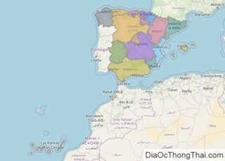
Occupying most of the Iberian Peninsula’s land area (approximately 85%), Spain is the third-largest country in Europe and 45% is covered by the Meseta Plateau. As observed on the physical map of Spain, the terrain of the land is highly undulating. That plateau is rarely flat, and is in reality a mostly hilly highland area divided by the Cordillera … Read more

Map of Australia

Map of Australia

Covering an area of 7,617,930 sq.km (2,969,907 sq mi), Australia is the smallest continent, the world’s 6th largest country and the largest country in Oceania. It is located between the Indian and Pacific Oceans in the Southern hemisphere. Australia is extremely dry, with about 35% of the country receiving very little rain (if any). Almost … Read more

Map of Mexico

Map of Mexico

Covering an area of 1,972,550 sq. km (761,610 sq mi), Mexico is a country located in the southern part of North America. As observed on the physical map of Mexico above, the country has an extremely diverse topography.  Mountains: The Sierra Madre Occidental Range runs north to south, from the Sonora-Arizona border southeast through Sonora, Chihuahua, Sinaloa, … Read more

Map of Indonesia

Map of Indonesia

Covering an area of 1,904,569 sq. km, and strategically positioned between the Pacific and Indian Oceans, Indonesia comprises over 17,504 islands and is by far the largest and the most varied archipelago on Earth. Of these islands, the larger islands of Sumatra, Java, Kalimantan (which comprises two-thirds of the island of Borneo), Sulawesi, and Irian … Read more

Map of Netherlands

Map of Netherlands

As observed on the physical map of the Netherlands, it is a very flat country with almost 25% of its land at, or below sea level. The country covers a total area of 41,865 sq. km.  Low rolling hills cover some of the central areas, and in the far south, the land rises into the … Read more

Map of Saudi Arabia

Map of Saudi Arabia

With an area of 2,150,000 sq. km, Saudi Arabia is the largest sovereign country of Arabia. It occupies nearly 80% of the area of the Arabian Peninsula and has extensive coastlines on the Red Sea and the Persian Gulf.  Saudi Arabia is, for the most part, an uninhabited desert land. As observed on the physical … Read more

Map of Turkey

Map of Turkey

Turkey occupies an area of 783,356 sq. km with 97% of this area located in Asia and the rest in Europe. As observed on the physical map of the country above, the European part of Turkey called Eastern Thrace is located at the extreme eastern edge of the Balkan Peninsula. The Asian part that is … Read more

Map of Switzerland

Map of Switzerland

Switzerland, a small landlocked country, covers an area of 41,285 sq. km in Europe. The country is famous across the world for its picturesque landscapes.  As observed on the physical map above, it is a highly mountainous nation covering nearly 60% of the country’s area. The Alpine ranges lie to the south and the Jura … Read more

Map of Poland

Map of Poland

Poland is a Central European country covering an area of 312,696 sq. km in Central Europe. As seen on the physical map above, the country has a coastline on the Baltic Sea to the north. The coastline is fairly smooth with beaches and sand dunes but indented by scattered low-rising cliffs. From the Baltic lowlands, … Read more

Map of Thailand

Map of Thailand

Thailand covers a total area of 513,120 sq. km in the Indo-Chinese Peninsula. The country has a varied landscape ranging from low mountains to fertile plains to sandy beaches.  As observed on the physical map of Thailand above, fold mountains dominate the country’s landscape to the north and west. These mountains extend southward (in a … Read more

Map of Sweden

Map of Sweden

Sweden, a Nordic nation in Northern Europe, covers an area of 450,295 sq. km.  The topography of the country is largely shaped by ice. During the last Ice Age, much of Sweden was covered by a thick layer of ice. By 6,000 BC, when that ice finally retreated (or melted) it left in its wake … Read more

Map of Belgium

Map of Belgium

Belgium is a Western European country occupying an area of 30,689 km2 (11,849 sq mi).  As can be observed on the physical map of Belgium there are three main geographical regions to Belgium: the coastal plain to the northwest, the central plateau, and the Ardennes uplands to the southeast. A small area called the Paris … Read more