Map of Bulgaria

Map of Bulgaria

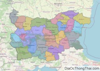
Noted for its diversity, Bulgaria’s landscape ranges from mountainous peaks covered in snow to valleys and lowlands giving way to the coast of the Black Sea. The Balkan Mountains cut across the central part of the country, while the Rhodope Mountains run through southern Bulgaria, along its border with Greece. The highest point in the … Read more

Map of Ghana

Map of Ghana

Ghana is a West African country with a coastline on the Gulf of Guinea and occupies a total area of 239,567 sq. km.  As observed on the map above, Ghana is dissected by the largest artificial lake on the planet (Lake Volta), nearly 50% of Ghana lies less than 152 meters above sea level. The … Read more

Map of Panama

Map of Panama

Panama is a transcontinental country covering an area of 75,417 sq. km (29,119 sq mi) from Central to South America. As observed on the physical map of Panama, the country’s landscape is dominated by forested, volcanic-in-origin, mountains that extend from its Costa Rican border to Colombia, South America. Significant ranges include the lengthy Central Mountains, … Read more

Map of Tanzania

Map of Tanzania

Tanzania has varied geography with several spectacular and globally famous natural features several of which have been represented on the physical map above.  The country has two branches of the East African Rift System that runs in the north-south direction through the country. The central part between these two mountain systems is occupied by a … Read more

Map of Belarus

Map of Belarus

A landlocked country in Eastern Europe, Belarus occupues an area of 207,595 sq. km (80,153 sq mi). As observed on the physical map of Belarus, it is a relatively low-lying country. It can be divided into two main parts: the Poltsk Lowland (north) and the Dnieper Lowland (south). Belarus is a heavily forested, flat, low-lying country that … Read more

Map of Costa Rica

Map of Costa Rica

Costa Rice covers an area of 51,100 sq. km (19,700 sq mi) in Centra America. As can be seen on the above map of Costa Rica, most of Costa Rica is dominated by the Sierra Madre Mountains, literally fractured into individual ranges and valleys by violent volcanic eruptions over eons of time. Speaking of volcanoes, the country’s most … Read more

Map of Croatia

Map of Croatia

Croatia is a European country occupying an area of 56,594 km2(21,851 sq mi). As observed on the physical map of Croatia, despite its relatively small size, the landscape is considerably diverse. It is made up of fertile and mostly flat plains in the north, and low mountains and highlands along the coast.  The Dinaric Alps … Read more

Map of Ivory Coast

Map of Ivory Coast

The Ivory Coast or Côte d’Ivoire is a country in West Africa covering an area of 322,463 sq. km. Most of Cote d’Ivoire (north to south) is a forested plateau, one that gradually slopes down to the Atlantic Ocean coastal areas. Exceptions are the edges of the Guinea Highlands (4000 – 5000 ft. peaks) on its western … Read more

Map of Uzbekistan

Map of Uzbekistan

Uzbekistan occupies an area of 447,000 sq. km in Central Asia. It is only one of the two countries in the world that is doubly-landlocked. The other one is Liechtenstein.  As can be observed on the physical map above, the topography of Uzbekistan is about 80% sandy, scrubby desert, including the massive Kyzyl Kum.  The … Read more

Map of Uruguay

Map of Uruguay

Covering an area of 176,000 sq.km (68,037 sq mi), Uruguay, located in Southern South America, is the 2nd smallest nation in South America. The eastern, southern and western plains in Uruguay eventually flow into the rolling hills and low mountains of the interior. In the southwest, the flat lowlands between the coastline and hills (Littoral) merge more … Read more

Map of Lithuania

Map of Lithuania

With an area of 65,300 sq. km, a population of about 2.8 million people, Lithuania is the largest and the most populous of the three Baltic Republics. Smoothed by glacier retreat during the last Ice Age, Lithuania is mostly flat lowlands in the west, with some low hills. In the east and southeast, bogs, numerous … Read more

Map of Macau

Map of Macau

Macau is a Special Administrative Region of China with an area of 115.4 sq. km. As observed on the physical map of Maco, the region comprises of a peninsula attached to mainland Asia and the islands of Coloane and Taipa in the South China Sea. Macao was formerly an island itself but was gradually connected … Read more