Map of Paraguay

Map of Paraguay

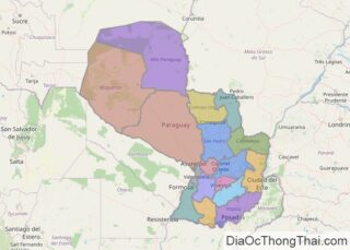
The landlocked nation of Paraguay covering an area of 406,752 sq.km (157,050 sq mi), is located in Central South America. As observed on the physical map of the country, Paraguay is crisscrossed by many rivers. The three largest rivers – the Paraguay, Parana and Pilcomayo -forms over 75% of the country’s borders. The Parana River forms the … Read more

Map of Uganda

Map of Uganda

Located on the edge of the Equator, Uganda is positioned in south-central Africa, and bordered by the Democratic Republic of the Congo (DRC), Kenya, Rwanda, Sudan and Tanzania. Uganda averages about 1,100 metres (3,609 ft) above sea level, and while much of its border is lakeshore, Uganda is landlocked with no access to the sea. … Read more

Map of Latvia

Map of Latvia

Latvia, a Baltic state in Europe lies along the eastern shores of the Baltic Sea and covers an area of 4,589 sq. km (24,938 sq mi). As observed on the physical map of the country above, Latvia is a very flat country of low-lying plains, largely covered by forest. There are some low hils in the west … Read more

Map of Estonia

Map of Estonia

Estonia is a Baltic country in Northern Europe with an area of 45,227 km2(17,462 sq mi). As observed on the physical map of Estonia, the country is mostly low and flat (close to sea level). It is also nearly surrounded by water on all sides. Estonia has 3,794 km (2,357 mi) of coastline indented by numerous bays, straits, … Read more

Map of Nepal

Map of Nepal

With an area of 147,516 sq. km, Nepal is a small nation in South Asia. Despite its size, however, Nepal is extensively diverse in terms of topography as observed on the physical map of the country above.  Mountains and rugged hills cover almost 75% of Nepal’s land area.  The elevation of land here rises from … Read more

Map of Yemen

Map of Yemen

Yemen is a sovereign nation with an area of 527,970 sq. km. Mainland Yemen lies in the Arabian Peninsula of Asia. The country has an extensive coastline of around 2,000 km and over 200 islands. As observed on the physical map of Yemen above, the Socotra Islands are also a part of the country. Yemen … Read more

Map of Cambodia

Map of Cambodia

Cambodia occupies an area of 181,035 sq. km in mainland Southeast Asia.  As observed on the physical map above, Cambodia is primarily a low-lying country with the Central Plain occupying an extensive part of its area. The plain features the basin of the Tonle Sap Lake, the Bassac River plain, and the flood-plains of the … Read more

Map of El Salvador

Map of El Salvador

Covering a total area of 21,041 sq. km (8,124 sq mi), El Salvador is a small mountainous Central American country, where there are two parallel mountain ranges bordering a central plateau. As observed on the physical map of El Salvador above, the Sierra Madre Mountains runs along the entire northern border with Honduras. In the south, the … Read more

Map of Honduras

Map of Honduras

Honduras occupies an area of 112,492 sq. km (43,433 sq. mi) in Central America. As observed on the physical map of Honduras, the country has three major topographical regions. These are a vast interior plateau of hills and mountains that dominate the landscape; the Caribbean lowlands, and the Pacific lowlands- fringing the Gulf of Fonseca.  … Read more

Map of Papua New Guinea

Map of Papua New Guinea

Covering an area of 462,840 sq.km (178,700 sq mi), Papua New Guinea is the 3rd largest island nation and the world’s 54th largest country. The nation of Papua New Guinea contains the eastern half of the island of New Guinea, as well as the islands of New Ireland, New Britain, and Bougainville, in addition to numerous smaller … Read more

Map of Cyprus

Map of Cyprus

With an area of 9,251 sq. km, Cyprus is the third largest Mediterranean Island. As observed on the physical map above, a very narrow band of mountains (the Kyrenia) slices across the northern edge of Cyprus. That low range of mountains reaches a maximum of 1,024 m (3,360 ft) in elevation. In the south and … Read more

Map of Iceland

Map of Iceland

The Nordic island nation of Iceland occupies an area of 103,000 km2 (40,000 sq miles) in the North Atlantic Ocean. The island owes its existence to a large volcanic fissure in the Mid-Atlantic Ridge, where the Eurasian and American tectonic plates meet. Even today, the country is growing by about 5 cm per year, as it … Read more