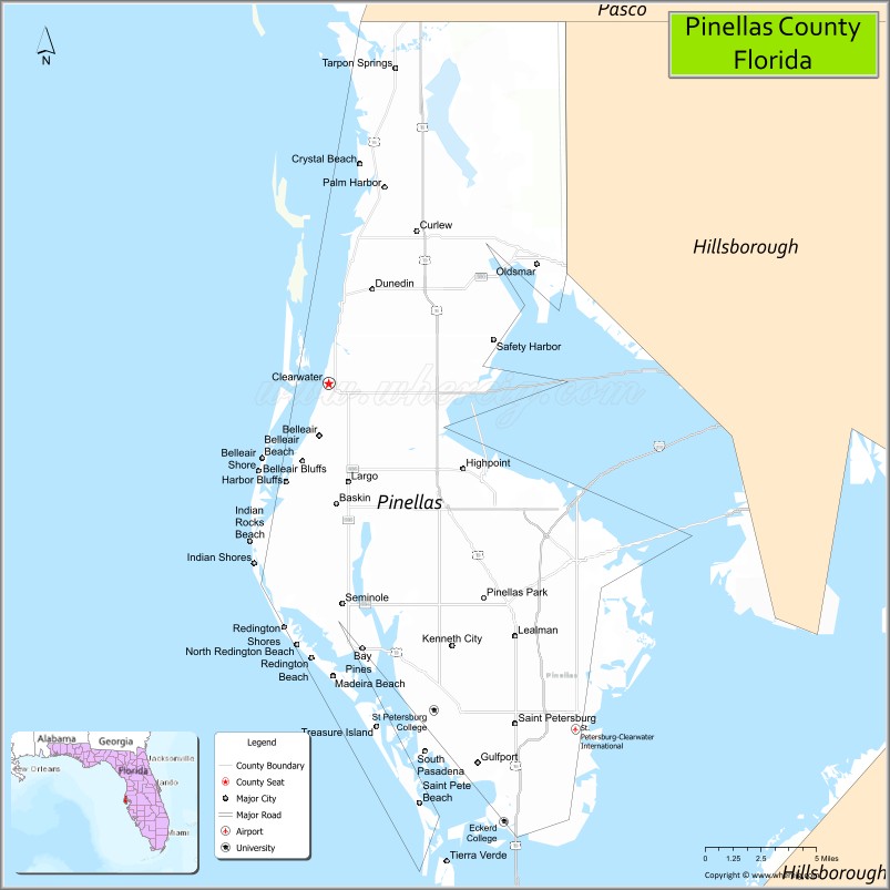
Pinellas County (US: /pɪˈnɛləs/, pih-NEL-əss) is a county located on the west central coast of the U.S. state of Florida. As of the 2020 census, the population was 959,107. It is the most densely populated county in Florida. The county is part of the Tampa–St. Petersburg–Clearwater, Florida Metropolitan Statistical Area. Clearwater is the county seat. St. Petersburg is the largest city as well as the largest city in Florida that is not a county seat.
| Name: | Pinellas County |
|---|---|
| FIPS code: | 12-103 |
| State: | Florida |
| Founded: | January 1, 1912 |
| Named for: | Spanish Punta Piñal (“Point of Pines”) |
| Seat: | Clearwater |
| Largest city: | St. Petersburg |
| Total Area: | 608 sq mi (1,570 km²) |
| Land Area: | 274 sq mi (710 km²) |
| Total Population: | 959,107 |
| Population Density: | 3,491/sq mi (1,348/km²) |
| Time zone: | UTC−5 (Eastern) |
| Summer Time Zone (DST): | UTC−4 (EDT) |
| Website: | www.pinellascounty.org |
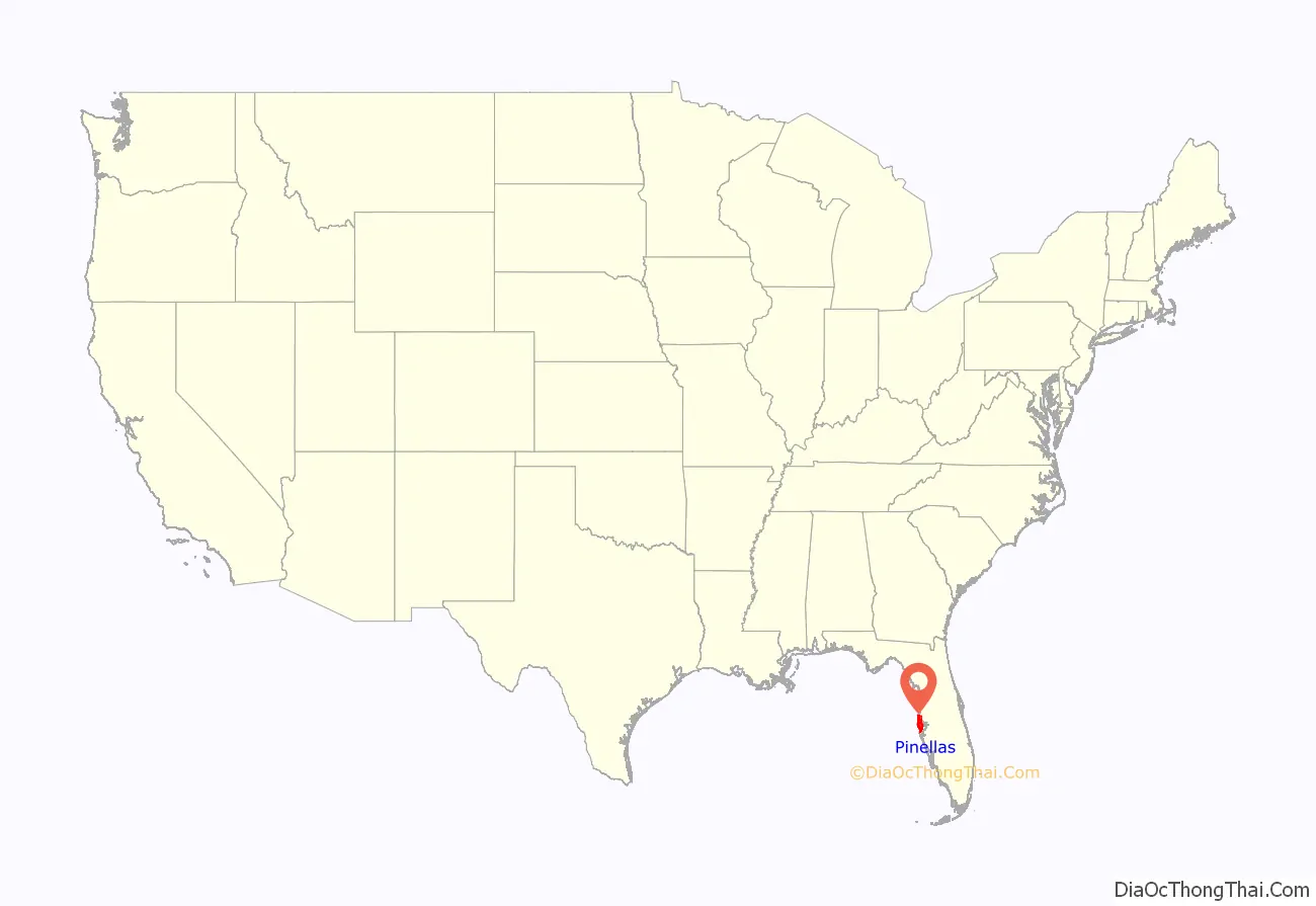
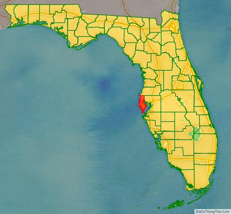
Pinellas County location map. Where is Pinellas County?
History
Pre-European settlement
When Europeans first reached the Pinellas peninsula, the Tampa Bay area was inhabited by people of the Safety Harbor culture. The Safety Harbor culture area was divided into chiefdoms. One documented chiefdom in what is now Pinellas County was that of the Tocobaga, who occupied a town and large temple mound, the Safety Harbor site, overlooking the bay in what is now Safety Harbor. The modern site is protected and can be visited as part of the County’s Philippe Park.
Spanish and British Florida
During the early 16th century Spanish explorers discovered and slowly began exploring Florida, including Tampa Bay. In 1528 Panfilo de Narvaez landed in Pinellas, and 10 years later Hernando de Soto is thought to have explored the Tampa Bay Area. By the early 18th century the Tocobaga had been virtually annihilated, having fallen victim to European diseases from which they had no immunity, as well as European conflicts. Later Spanish explorers named the area Punta Piñal (Spanish for “Point of Pines” or “Piney Point”). After trading hands multiple times between the British and the Spanish, Spain finally ceded Florida to the United States in 1821, and in 1823 the U.S. Army established Fort Brooke (later Tampa).
Settlement of West Hillsborough
In 1834 much of west central Florida, including the Pinellas peninsula (then known simply as West Hillsborough), was organized as Hillsborough County. The very next year Odet Philippe, a French Huguenot from Charleston, South Carolina became the first permanent, non-native resident of the peninsula when he established a plantation near the site of the Tocobaga village in Safety Harbor. It was Philippe who first introduced both citrus culture and cigar-making to Florida.
Around the same time, the United States Army began construction of Fort Harrison, named after William Henry Harrison, as a rest post for soldiers from nearby Fort Brooke during the Second Seminole War. The new fort was located on a bluff overlooking Clear Water Harbor, which later became part of an early 20th-century residential development (now historic district) called Harbor Oaks. University of South Florida archaeologists excavated the site in 1977 after Alfred C. Wyllie discovered an underground ammunition bunker while digging a swimming pool on his estate. Clearwater would later become the first organized community on the peninsula as well as the site of its first post office.
The Armed Occupation Act, passed in 1842, encouraged further settlement of Pinellas, like all of Florida, by offering 160 acres (0.65 km) to anyone who would bear arms and cultivate the land. Pioneer families like the Booths, the Coachmans, the Marstons, and the McMullens established homesteads in the area in the years following, planting more citrus groves and raising cattle. During the American Civil War, many residents fought for the Confederate States of America. Brothers James and Daniel McMullen were members of the Confederate Cow Cavalry, driving Florida cattle to Georgia and the Carolinas to help sustain the war effort. John W. Marston served in the 9th Florida Regiment as a part of the Appomattox Campaign. Many other residents served in other capacities. Otherwise the peninsula had virtually no significance during the war, and the war largely passed the area by.
On September 27, 1848, a strong hurricane struck the West Coast of Florida. It separated the barrier island on the coast and created a waterway known today as John’s Pass. John Levique, along with Joseph Silva, was the one who discovered it and named it after himself and is now a federally owned canal.
Tarpon Springs became West Hillsborough’s first incorporated city in 1887, and in 1888 the Orange Belt Railway was extended into the southern portion of the peninsula. Railroad owner Peter Demens named the town that grew near the railroad’s terminus St. Petersburg in honor of his hometown. The town would incorporate in 1892. Other major towns in the county incorporated during this time were Clearwater (1891), Dunedin (1899), and Largo (1905).
Construction of Fort De Soto, on Mullet Key facing the mouth of Tampa Bay, was begun in 1898 during the Spanish–American War to protect Tampa Bay from potential invading forces. The fort, a subpost of Fort Dade on adjacent Egmont Key (which lies in the mouth of Tampa Bay), was equipped with artillery and mortar batteries.
Birth of Pinellas County
Even into the early years of the 20th century, West Hillsborough had no paved roads, and transportation posed a major challenge. A trip to the county seat, across the bay in Tampa, was generally an overnight affair and the automobiles that existed on the peninsula at that time would frequently become bogged down in the muck after rainstorms. Angry at what was perceived as neglect by the county government, residents of Pinellas began a push to secede from Hillsborough. They succeeded, and on January 1, 1912 Pinellas County came into being. The peninsula, along with a small part of the mainland were incorporated into the new county.
Land boom and prohibition
Aviation history was made in St. Petersburg on January 1, 1914 when Tony Jannus made the world’s first scheduled commercial airline flight with the St. Petersburg-Tampa Airboat Line from St. Petersburg to Tampa. The popular open-air St. Petersburg concert venue Jannus Live (formerly known as Jannus Landing) memorializes the flight.
The early 1920s saw the beginning of a land boom in much of Florida, including Pinellas. During this period municipalities issued a large number of bonds to keep pace with the needed infrastructure, such as roads and bridges. The travel time to Tampa was cut in half—from 43 to 19 miles (69 to 31 km)—by the opening of the Gandy Bridge in 1924, along the same route Jannus’ airline used. It was the longest automobile toll bridge in the world at the time.
Prohibition was unpopular in the area and the peninsula’s countless inlets and islands became havens for rumrunners bringing in liquor from Cuba. Others distilled moonshine in the County’s still plentiful woods.
Great Depression and World War II
As was the case in much of Florida, the Great Depression came early to Pinellas with the collapse of the real estate boom in 1926. Local economies came into severe difficulties, and by 1930, St. Petersburg defaulted on its bonds. Only after World War II would significant growth return to the area. During the war, the area’s tourist industry collapsed, but thousands of recruits came to the area when the U.S. military decided to use the area for training. Area hotels became barracks. The Vinoy Park Hotel was used as an Army training school. The area’s women and girls participated in the war effort as well. Hundreds of girls from the area’s most prominent families formed a group called the Bomb-a-Dears, holding dances, socializing with recruits, and selling war bonds. After the war many of these same soldiers remembered their wartime experience in Pinellas well, and returned as tourists or residents.
Recent history
With the end of the Second World War, Pinellas would enter another period of rapid growth and development. In 1954 the original span of the Sunshine Skyway Bridge was opened, replacing earlier ferry service. By 1957 Clearwater was America’s fastest growing city.
Tragedy struck on May 9, 1980, when the southbound span of the original Sunshine Skyway Bridge was struck by the freighter MV Summit Venture during a storm, sending over 1,200 feet (370 m) of the bridge plummeting into Tampa Bay. The collision caused ten cars and a Trailways bus to fall 150 feet (46 m) into the water, killing 35 people. The new bridge opened in 1987 and has since been listed as #3 of the “Top 10 Bridges” in the World by the Travel Channel.
The county operates a 21-acre (8.5 ha) living history museum called Heritage Village containing more than 28 historic structures, some dating back to the 19th century, where visitors can experience what life was once like in Pinellas.
Pinellas County celebrated 100 years of existence on January 1, 2012.
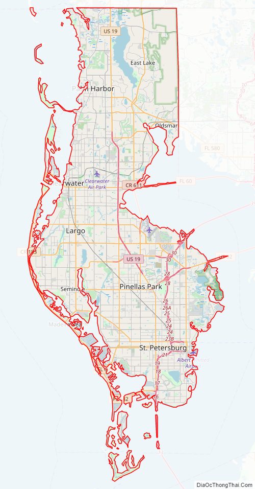
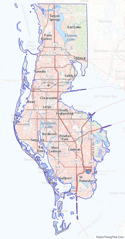
Pinellas County Road Map
Geography
According to the U.S. Census Bureau, the county has a total area of 608 square miles (1,570 km), of which 274 square miles (710 km) is land and 334 square miles (870 km) (55.0%) is water. It is the second-smallest county in Florida by land area, larger than only Union County. Pinellas forms a peninsula bounded on the west by the Gulf of Mexico and on the south and east by Tampa Bay. It is 38 miles (61 km) long and 15 miles (24 km) wide at its broadest point, with 587 miles (945 km) of coastline.
Physical geography
Elevation in the county ranges from mean sea level to its highest natural point of 110 feet (34 m) near the intersection of SR 580 and Countryside Blvd. in Clearwater. Due to its small size and high population, by the early 21st century Pinellas County has been mostly built out, with very little developable land left available. The county has maintained a fairly large system of parks and preserves that provide residents and visitors retreat from the city and a glimpse of the peninsula’s original state.
Geologically, Pinellas is underlain by a series of limestone formations, the Hawthorne limestone and the Tampa limestone. The limestone is porous and stores a large quantity of water. The Hawthorne formation forms a prominent ridge down the spine of the county, from east of Dunedin, south to the Walsingham area and east towards St. Petersburg.
The 35 miles of beaches and dunes which make up the county’s 11 barrier islands provide habitat for coastal species, serve as critical storm protection for the inland communities, and form the basis of the area’s thriving tourism industry. The islands are dynamic, with wave action building some islands further up, eroding others, and forming entirely new islands over time. Though hurricanes are infrequent on this part of Florida’s coast, they have had a major impact on the islands, with the Hurricane of 1848 forming John’s Pass between Madeira Beach and Treasure Island, a hurricane in 1921 creating Hurricane Pass and cleaving Hog Island into Honeymoon and Caladesi Islands, and 1985’s Hurricane Elena sealing Dunedin Pass to join Caladesi with Clearwater Beach.
Between the barrier islands and the peninsula are several bodies of water, through which traverses a section of the Gulf Intracoastal Waterway. From north to south they are: St. Joseph Sound between the islands and Dunedin, Clearwater Harbor between Clearwater and Clearwater Beach, and Boca Ciega Bay in the southern third of the county. Connecting Clearwater Harbor to Boca Ciega Bay is a thin, approximately 3.5-mile (5.6 km) stretch of water known as The Narrows, which runs next to the town of Indian Shores.
Extending from northeastern Boca Ciega Bay, Long Bayou separates Seminole from St. Petersburg near Bay Pines. Long Bayou once extended significantly farther up the peninsula until the northern portion was sealed off to create Lake Seminole. Extending further still from Long Bayou, the Cross Bayou Canal traverses the peninsula, crossing Pinellas Park in a northeasterly direction before emptying into Tampa Bay on the northwest side of St. Petersburg-Clearwater International Airport.
- Anclote Key- offshore of Tarpon Springs and the northernmost point in the county
- Howard Park- a man-made pocket beach created in the 1960s
- Three Rooker Bar- the most geologically recent of Pinellas’ barrier islands
- Honeymoon Island
- Hurricane Pass
- Caladesi Island
- Dunedin Pass– shoaled and closed in the 1980s, linking Caladesi Island and Clearwater Beach
- Clearwater Beach
- Clearwater Pass
- Sand Key- the longest of Pinellas’ barrier islands
- John’s Pass
- Treasure Island
- Blind Pass
- Long Key (St. Pete Beach)
- Pass-a-Grille Channel
- Shell Key
- Tierra Verde- on the bay side of Shell Key, links the mainland to Fort De Soto. Created by a dredge-and-fill project that merged several smaller Keys, including Cabbage and Pine Keys
- Bunces Pass
- Mullet Key- home to Fort De Soto and the southernmost point in the county
National protected area
- Pinellas National Wildlife Refuge
State protected areas
- Honeymoon Island State Park
- Caladesi Island State Park
- Anclote Key Preserve State Park
County parks and preserves
Pinellas County parks gallery
Anderson Park Panorama
Brooker Creek Nature Preserve walkway
View of Lake Tarpon from John Chestnut Park
Wall Springs View of St Joseph Sound from the old observation tower
Sunset at Fred Howard Park
Other protected areas
Boyd Hill Nature Preserve- A 245-acre park on the shores of Lake Maggiore in south St. Petersburg, operated by the city and featuring a nature center, bird-of-prey aviary, and over three miles of trails through a variety of ecosystems.
Adjacent counties
- Pasco County — north
- Hillsborough County — east and south
Hillsborough County extends along the shipping channel towards Egmont Key and into the Gulf of Mexico, separating Pinellas County from Manatee County.
Pinellas County Topographic Map
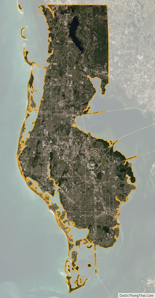
Pinellas County Satellite Map
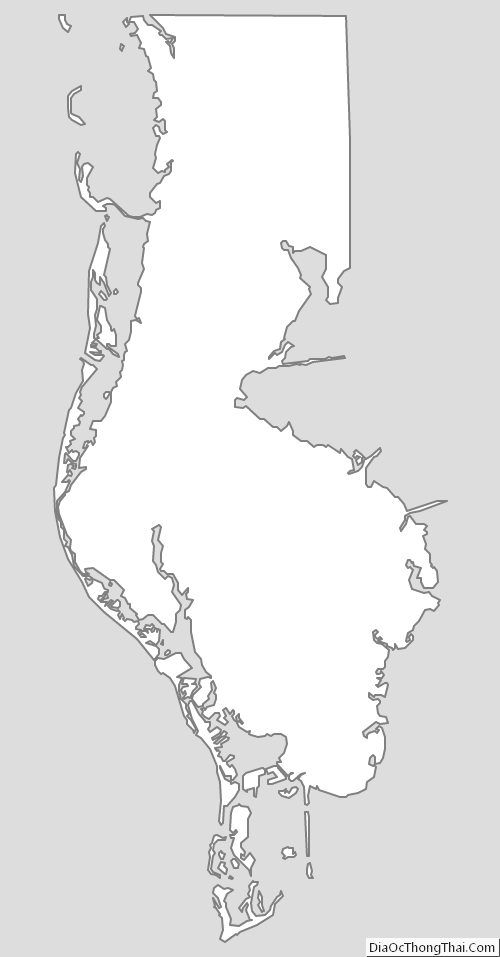
Pinellas County Outline Map