Map of Cayman Islands

Map of Cayman Islands

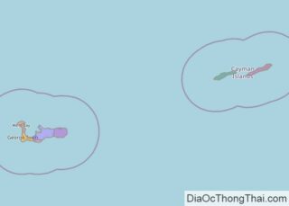
Covering an area of 264 sq. km, the three-island groups of Grand Cayman, Cayman Brac, and Little Cayman together form the British Overseas Territory of Cayman Islands, which are located in the northwestern Caribbean Sea. The islands are the peaks of a massive underwater ridge, known as the Cayman Ridge. These peaks just barely break … Read more

Map of Togo

Map of Togo

Togo is a small country occupying an area of only 56,785 sq. km in West Africa. The country extends as a long strip of land from its southern coast on the Bight of Benin. The coastline is 56 km long. The country is divided into six distinct geographic regions.  To the south, the landscape along … Read more

Map of Barbados

Map of Barbados

Barbados, the easternmost island in the Caribbean Sea, is relatively flat and less mountainous, in comparison to its more-mountainous island neighbours to the west. It has an area of 439 sq. km (169 sq mi). As observed on the physical map of Barbados above, the island is roughly triangular in shape. In the western half, the land … Read more

Map of Eswatini

Map of Eswatini

One of the smallest countries in Africa, Eswatini (previously known in English as Swaziland) occupies an area of only 17,364 sq. km. Despite its small size, Eswatini features a variety of landscapes. On the physical map above you see the Lubombo Mountain ridge runs along the country’s border with Mozambique in the northeast. It has … Read more

Map of Guyana

Map of Guyana

Covering an area of 215,000 sq. km, Guyana, located on the northern edge of South America, is the 3rd smallest nation in South America. Guyana can be divided into four main geographical regions: there’s a narrow and swampy coastal plain, a hillier sandy region in the east, the (15,000 sq. km) Rupununi Savannah of the … Read more

Map of Suriname

Map of Suriname

Covering an area of 163,820 sq.km (63,252 sq mi), Suriname is one of the smallest sovereign nations, located on the northern edge of South America. Suriname can be divided into two main geographic regions; the coastal lowlands of the north and the tropical rainforests and savanna of the west and south. As observed on the physical map … Read more

Map of Sierra Leone

Map of Sierra Leone

The West African country of Sierra Leone occupies an area of 71,740 sq. km. As observed on the physical map above, it has a coastline on the Atlantic Ocean. Sierra Leone has four distinct physical regions.  A coastal swamp region that runs parallel to the Atlantic coast for around 320 km and comprises of a … Read more

Map of Virgin Islands

Map of Virgin Islands

The U.S. Virgin Islands is an organized and unincorporated island territory of the United States of America, located between the North Atlantic Ocean and the Caribbean Sea. Covering a total land area of 346.36 sq. km. As observed on the physical map of the US Virgin Islands above, the territory consists of three main islands: … Read more

Map of Djibouti

Map of Djibouti

Djibouti is an East African country with an area of 23,200 sq. km. As observed on the map, most of the country is a desert wasteland. From the narrow coastal plain of the country to the north, the land gradually rises in elevation to form a series of mountains. Some of these like the Mabla … Read more

Map of Andorra

Map of Andorra

Andorra is a tiny landlcoked nation occupying an area of 467.63 km2(180.55 sq mi) in southwestern Europe.  As observed on the physical map of Andorra, the is predominantly covered by rugged mountains of the Pyrenees. The highest elevation in the country is Coma Pedrosa at 2,942 m (9,652 ft). Also seen on the map above are three narrow river … Read more

Map of Liberia

Map of Liberia

Located on the West African coast, Liberia covers an area of 111,369 sq. km.  Four physiographic regions run nearly parallel to the Atlantic coast of the country. As observed on Liberia’s physical map, the elevation of the land gradually increases with distance from the coast. The coastal plains are around 560 km long and 40 … Read more

Map of Aruba

Map of Aruba

Aruba is an island country covering an area of 179 sq. km, in the south western Caribbean, off the Venezuelan coast. As observed on the physical map above, Aruba is mostly a dry and flat riverless island. It is famous for its white, sandy beaches on the western and southern coasts. The northern and eastern … Read more