Aruba is an island country covering an area of 179 sq. km, in the south western Caribbean, off the Venezuelan coast.
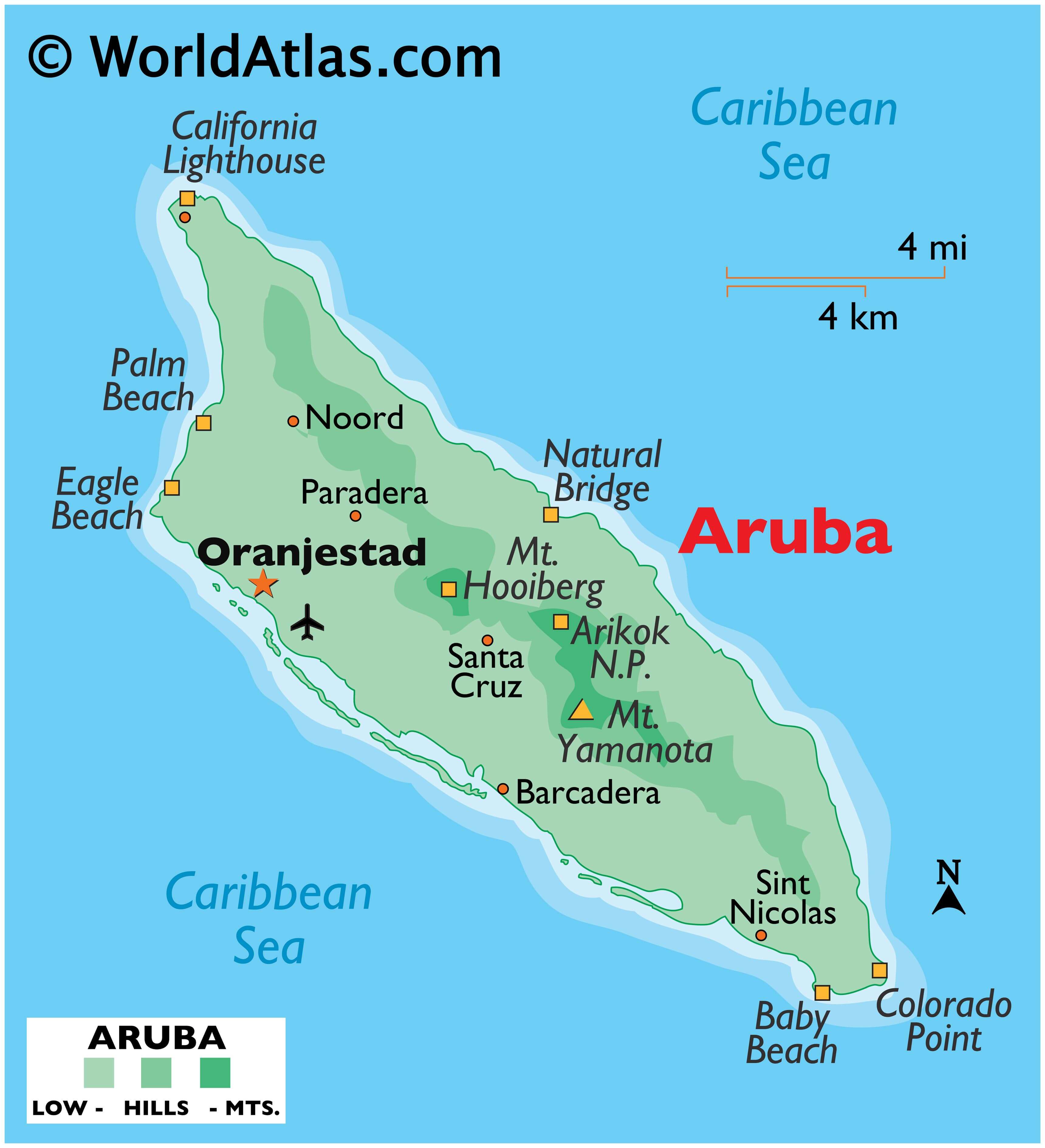
As observed on the physical map above, Aruba is mostly a dry and flat riverless island. It is famous for its white, sandy beaches on the western and southern coasts.
The northern and eastern edges of the island are exposed to higher winds; consequently having fewer sand beaches, much rougher seas and a rocky coastline.
The highest point on the island is Mount Yamanota at 188m (617ft) above sea level. The interior parts of the island are characterized by scattered rolling hills, including Hooiberg Mountain, at 165m (541ft).
| Flag: | 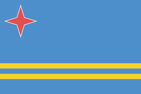 |
|---|---|
| Legal Name: | Aruba |
| Capital Value: | Oranjestad |
| Official languages: |
|
| Demonym(s): | Aruban |
| Government: | Devolved parliamentary representative democracy within a constitutional monarchy |
| Legislature: | Parliament of Aruba |
| Total Area: | 180 km² |
| Land Area: | 180 km² |
| Population: | 106,314 |
| Density: | 624/km (1,616.2/sq mi) (22nd) |
| GDP: | $3.06 Billion |
| GDP Per Capita: | $29,007.69 |
| Currency Value: | Aruban guilders/florins |
| Driving side: | right |
| Calling code: | +297 |
| Internet TLD: | .aw |
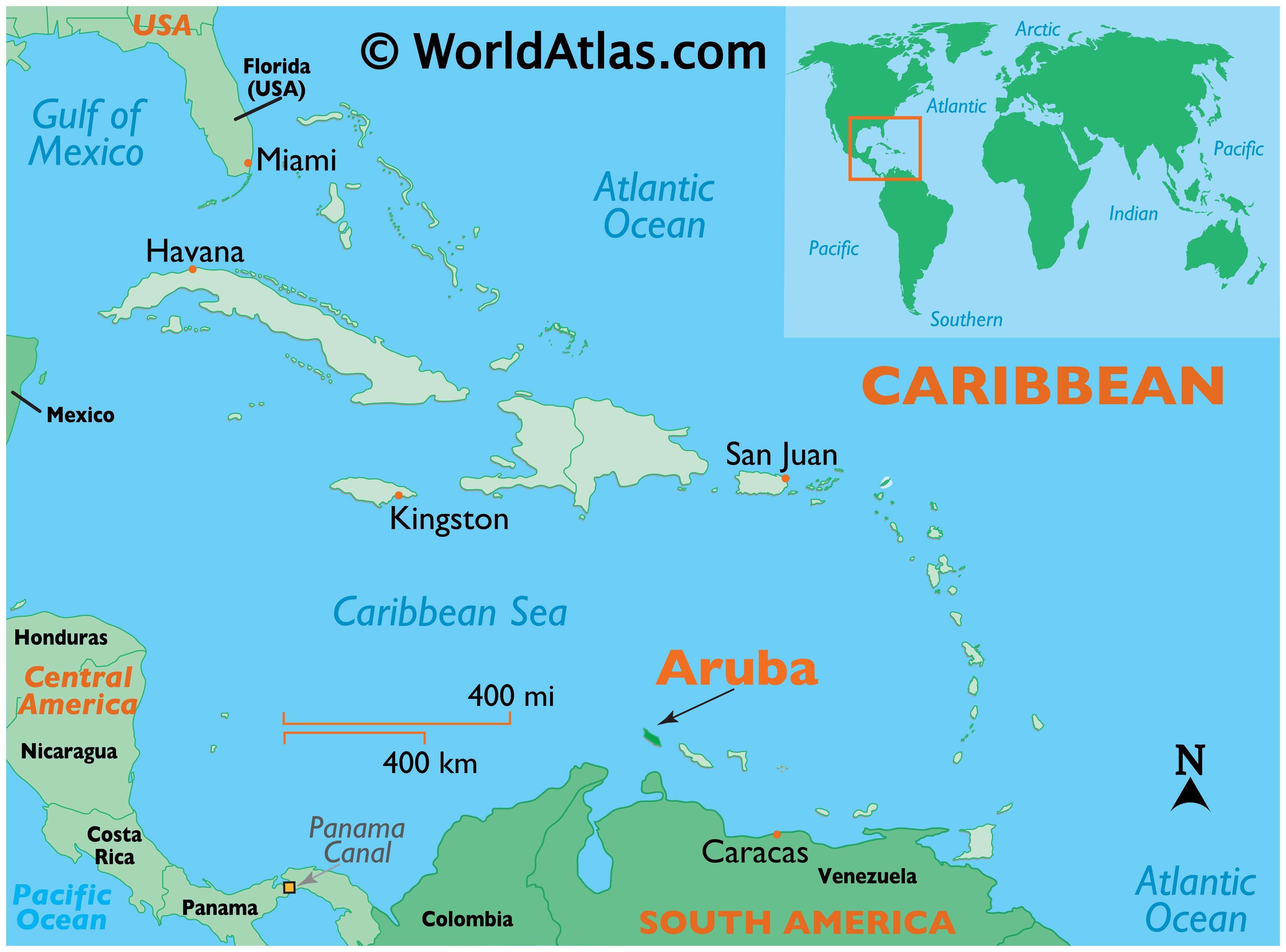
Location Maps
Where is Aruba?

High Definition Political Map of Aruba
History
Pre-colonial era
There has been a human presence on Aruba from as early as circa 2000 BC. The first identifiable group are the Arawak Caquetío Amerindians who migrated from South America about 1000 AD. Archaeological evidence suggests continuing links between these native Arubans and Amerindian peoples of mainland South America.
Spanish colonization
The first Europeans to visit Aruba were Amerigo Vespucci and Alonso de Ojeda in 1499, who claimed the island for Spain. Both men described Aruba as an “island of giants”, remarking on the comparatively large stature of the native Caquetíos. Vespucci returned to Spain with stocks of cotton and brazilwood from the island and described houses built into the ocean. Vespucci and Ojeda’s tales spurred interest in Aruba, and the Spanish began colonising the island. Alonso de Ojeda was appointed the island’s first governor in 1508. From 1513 the Spanish began enslaving the Caquetíos, sending many to a life of forced labour in the mines of Hispaniola. The island’s low rainfall and arid landscape meant that it was not considered profitable for a slave-based plantation system, so the type of large-scale slavery so common on other Caribbean islands never became established on Aruba.
Early Dutch period
The Netherlands seized Aruba from Spain in 1636 in the course of the Thirty Years’ War. Peter Stuyvesant, later appointed to New Amsterdam (New York), was the first Dutch governor. Those Arawak who had survived the depredations of the Spanish were allowed to farm and graze livestock, with the Dutch using the island as a source of meat for their other possessions in the Caribbean. Aruba’s proximity to South America resulted in interactions with the cultures of the coastal areas; for example, architectural similarities can be seen between the 19th-century parts of Oranjestad and the nearby Venezuelan city of Coro in Falcón State. Historically, Dutch was not widely spoken on the island outside of colonial administration; its use increased in the late 19th and early 20th centuries. Students on Curaçao, Aruba, and Bonaire were taught predominantly in Spanish until the late 18th century.
During the Napoleonic Wars, the British Empire took control of the island, occupying it between 1806 and 1816, before handing it back to the Dutch as per the terms of the Anglo-Dutch Treaty of 1814. Aruba subsequently became part of the Colony of Curaçao and Dependencies along with Bonaire. During the 19th century, an economy based on gold mining, phosphate production and aloe vera plantations developed, but the island remained a relatively poor backwater.
20th and 21st centuries
The first oil refinery in Aruba was built in 1928 by Royal Dutch Shell. The facility was built just to the west of the capital city, Oranjestad, and was commonly called the Eagle. Immediately following that, another refinery was built by Lago Oil and Transport Company, in an area now known as San Nicolas on the east end of Aruba. The refineries processed crude oil from the vast Venezuelan oil fields, bringing greater prosperity to the island. The refinery on Aruba grew to become one of the largest in the world.
During World War II, the Netherlands was occupied by Nazi Germany. In 1940, the oil facilities in Aruba came under the administration of the Dutch government-in-exile in London, causing them to be attacked by the German navy in 1942.
In August 1947, Aruba formulated its first Staatsreglement (constitution) for Aruba’s status aparte as an autonomous state within the Kingdom of the Netherlands, prompted by the efforts of Henny Eman, a noted Aruban politician. By 1954, the Charter of the Kingdom of the Netherlands was established, providing a framework for relations between Aruba and the rest of the Kingdom. That created the Netherlands Antilles, which united all of the Dutch colonies in the Caribbean into one administrative structure. Many Arubans were unhappy with the arrangement, however, as the new polity was perceived as being dominated by Curaçao.
In 1972, at a conference in Suriname, Betico Croes, a politician from Aruba, proposed the creation of a Dutch Commonwealth of four states: Aruba, the Netherlands, Suriname, and the Netherlands Antilles, each to have its own nationality. Backed by his newly created party, the Movimiento Electoral di Pueblo, Croes sought greater autonomy for Aruba, with the long-term goal of independence, adopting the trappings of an independent state in 1976 with the creation of a flag and national anthem. In March 1977, a referendum was held with the support of the United Nations. 82% of the participants voted for complete independence from the Netherlands. Tensions mounted as Croes stepped up the pressure on the Dutch government by organising a general strike in 1977. Croes later met with Dutch Prime Minister Joop den Uyl, with the two sides agreeing to assign the Institute of Social Studies in The Hague to prepare a study for independence, entitled Aruba en Onafhankelijkheid, achtergronden, modaliteiten, en mogelijkheden; een rapport in eerste aanleg (Aruba and independence, backgrounds, modalities, and opportunities; a preliminary report) (1978).
Autonomy
In March 1983, Aruba reached an official agreement within the Kingdom for its independence, to be developed in a series of steps as the Crown granted increasing autonomy. In August 1985, Aruba drafted a constitution that was unanimously approved. On 1 January 1986, after elections were held for its first parliament, Aruba seceded from the Netherlands Antilles, officially becoming a country of the Kingdom of the Netherlands, with full independence planned for 1996. However, Croes was seriously injured in a traffic accident in 1985, slipping into a coma. He died in 1986, never seeing the enacting of status aparte for Aruba for which he had worked over many years.
After his death, Croes was proclaimed Libertador di Aruba. Croes’ successor, Henny Eman, of the Aruban People’s Party (AVP), became the first Prime Minister of Aruba. In 1985, Aruba’s oil refinery had closed. It had provided Aruba with 30 percent of its real income and 50 percent of government revenue. The significant blow to the economy led to a push for a dramatic increase in tourism, and that sector has expanded to become the island’s largest industry. At a convention in The Hague in 1990, at the request of Aruba’s Prime Minister Nelson Oduber, the governments of Aruba, the Netherlands, and the Netherlands Antilles postponed indefinitely Aruba’s transition to full independence. The article scheduling Aruba’s complete independence was rescinded in 1995, although it was decided that the process could be revived after another referendum.
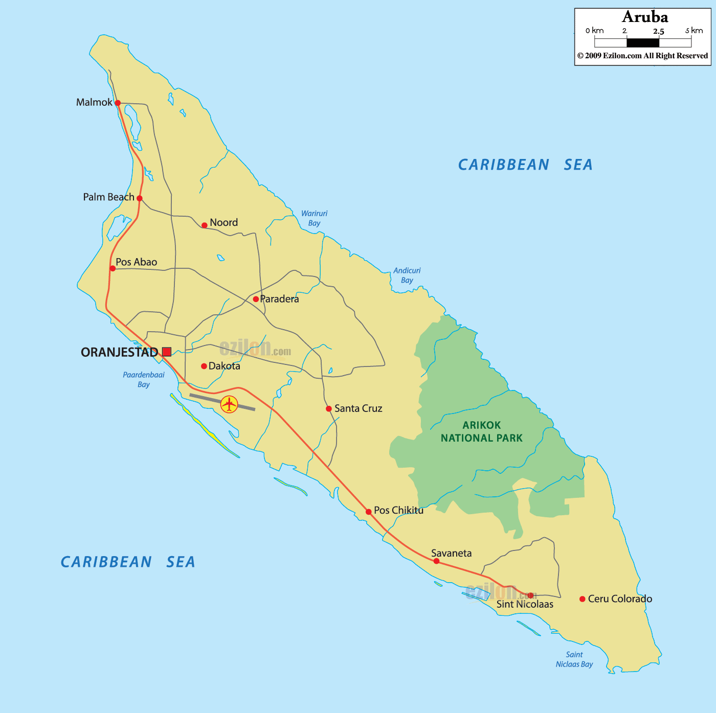
Physical Map of Aruba
Geography
Aruba is a generally flat, riverless island in the Leeward Antilles island arc of the Lesser Antilles in the southern part of the Caribbean. It lies 77 km (48 mi) west of Curaçao and 29 km (18 mi) north of Venezuela‘s Paraguaná Peninsula. Aruba has white sandy beaches on the western and southern coasts of the island, relatively sheltered from fierce ocean currents. This is where the bulk of the population live and where most tourist development has occurred. The northern and eastern coasts, lacking this protection, are considerably more battered by the sea and have been left largely untouched. As of 2022, Aruba only has 2.3% of forest-covered land area and only 0.5% of protected natural area.
The hinterland of the island features some rolling hills, such as Hooiberg at 165 meters (541 ft) and Jamanota, the highest on the island at 188 meters (617 ft) above sea level. Oranjestad, the capital, is located at 12°31′01″N 70°02′04″W / 12.51694°N 70.03444°W / 12.51694; -70.03444.
The Natural Bridge was a large, naturally formed limestone bridge on the island’s north shore. It was a popular tourist destination until its collapse in 2005.
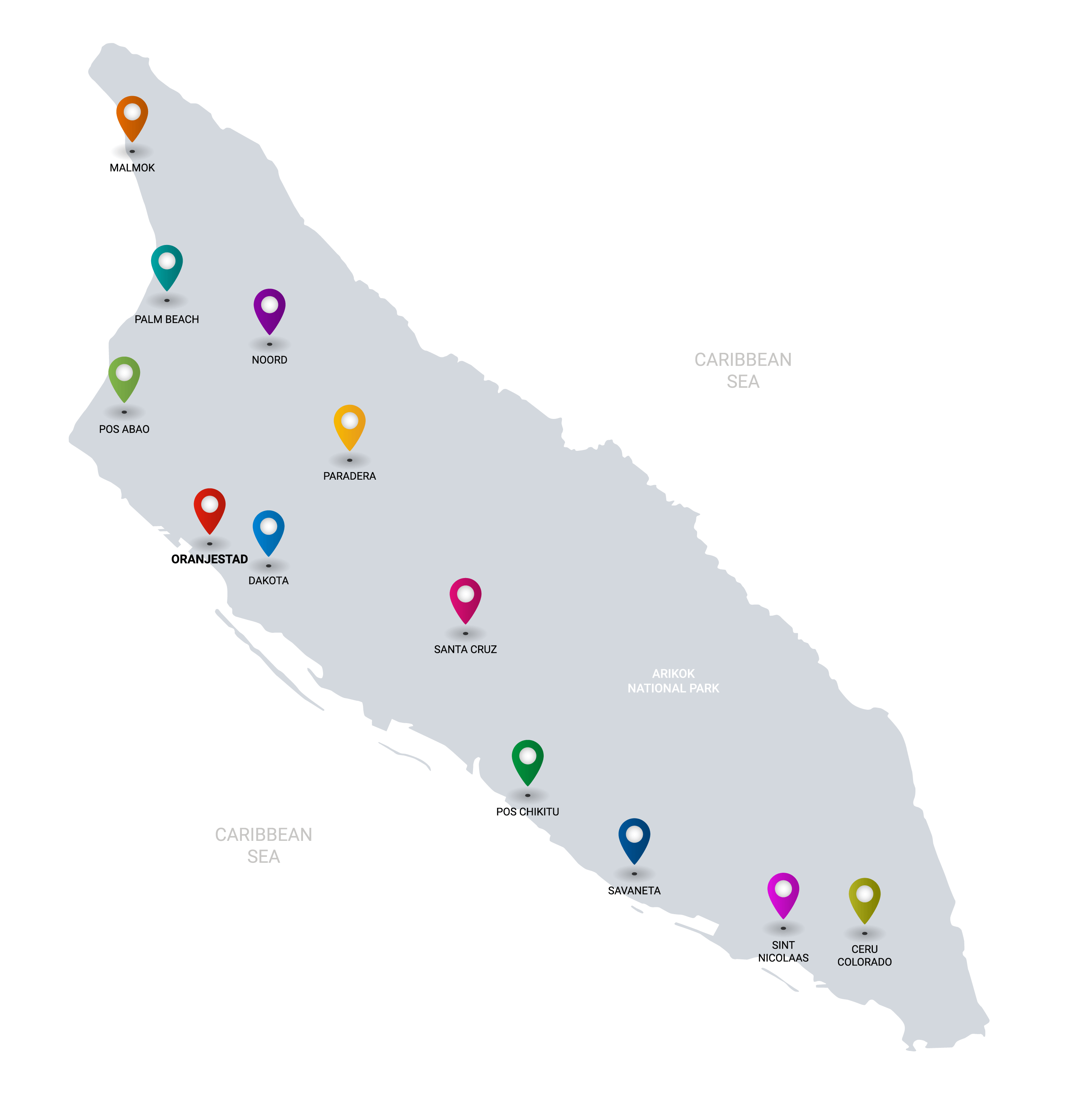
Cities and towns
The island, with a population of about 116,600 people (1 January 2019 estimate) does not have major cities. It is divided into six districts. Most of the island’s population resides in or around the two major city-like districts of Oranjestad (the capital) and San Nicolaas. Oranjestad and San Nicolaas are both divided into two districts for census purposes only.
The districts are as follows:
- Noord
- Oranjestad (East and West)
- Paradera
- San Nicolaas (North and South)
- Santa Cruz
- Savaneta
Fauna
The isolation of Aruba from the mainland of South America has fostered the evolution of multiple endemic animals. The island provides a habitat for the endemic Aruban Whiptail and Aruba Rattlesnake, as well as an endemic subspecies of Burrowing Owl and Brown-throated Parakeet.
Flora
The flora of Aruba differs from the typical tropical island vegetation. Xeric scrublands are common, with various forms of cacti, thorny shrubs, and evergreens. Aloe vera is also present, its economic importance earning it a place on the coat of arms of Aruba.
Cacti like Melocactus and Opuntia are represented on Aruba by species like Opuntia stricta. Trees like Caesalpinia coriaria and Vachellia tortuosa are drought tolerant.
Climate and natural hazards
By the Köppen climate classification, Aruba has a hot semi-arid climate (Köppen BSh). Rainfall is scarce, only 500 millimetres or 20 inches per year; in particular, rainy season is drier than it normally is in tropical climates; during the dry season, it almost never rains. Owing to the scarcity of rainfall, the landscape of Aruba is arid. Mean monthly temperature in Oranjestad varies little from 27.0 °C (80.6 °F) to 29.6 °C (85.3 °F), moderated by constant trade winds from the Atlantic Ocean, which come from the north-east. Yearly rainfall barely exceeds 450 millimetres or 18 inches in Oranjestad, although it is extremely variable and can range from as little as 150 millimetres or 6 inches during strong El Niño years (e.g. 1911/1912, 1930/1931, 1982/1983, 1997/1998) to over 1,000 millimetres or 39 inches in La Niña years like 1933/1934, 1970/1971 or 1988/1989.
Aruba is south of the typical latitudes of hurricanes but was affected by two in their early stages in late 2020.