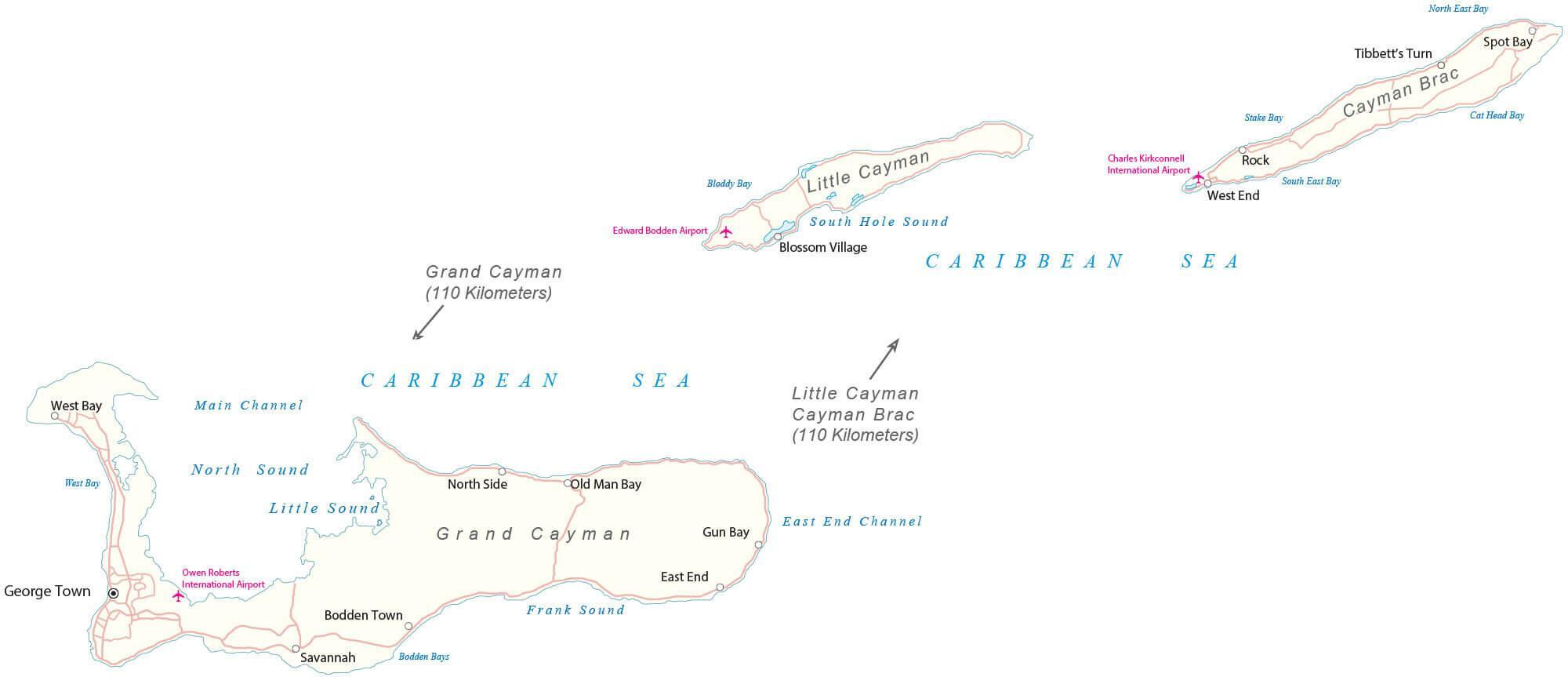
Covering an area of 264 sq. km, the three-island groups of Grand Cayman, Cayman Brac, and Little Cayman together form the British Overseas Territory of Cayman Islands, which are located in the northwestern Caribbean Sea. The islands are the peaks of a massive underwater ridge, known as the Cayman Ridge. These peaks just barely break the surface and flank the Cayman Trough, extending from Sierra Maestra to the Misteriosa Bank.
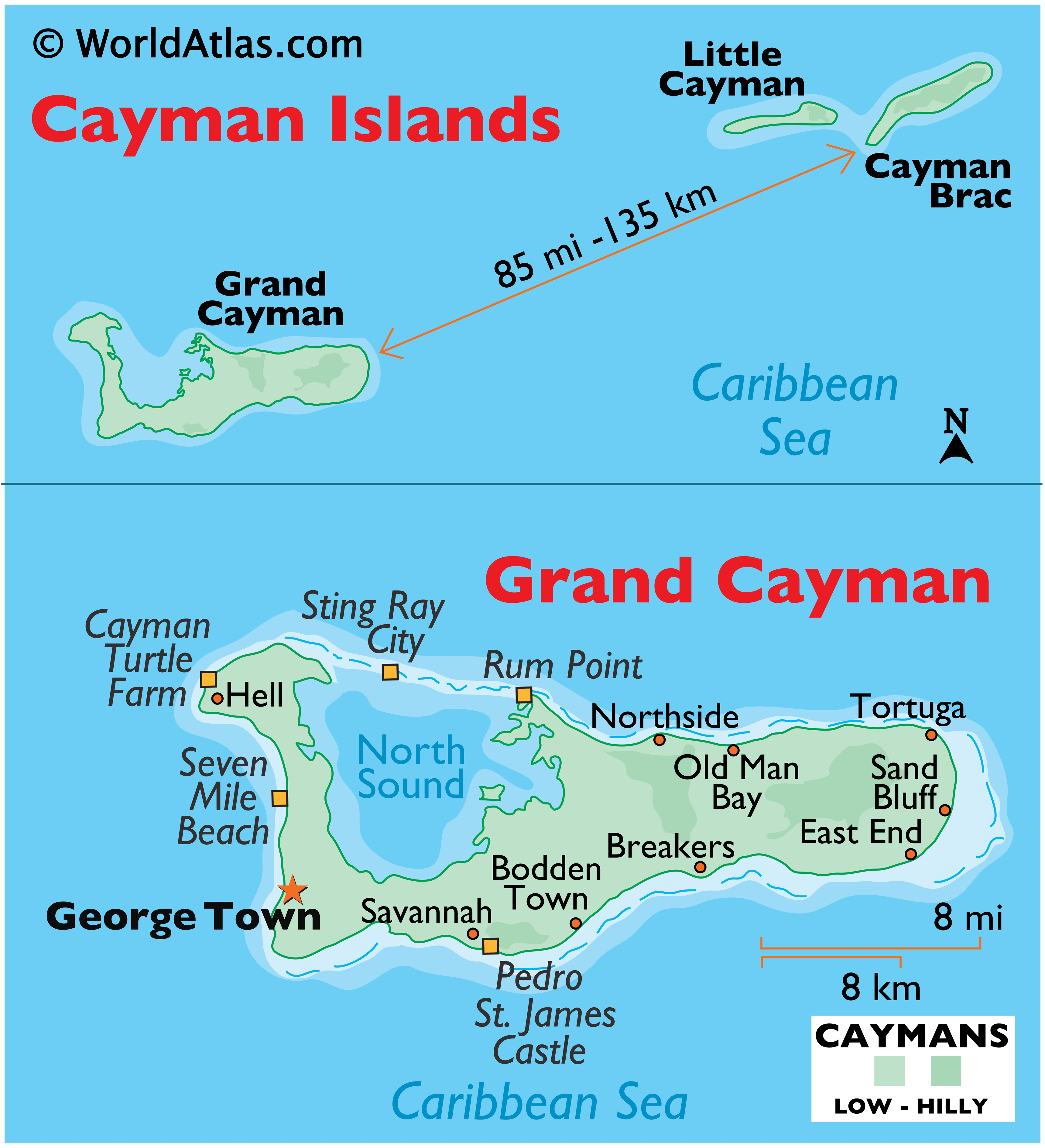
The terrain itself is mostly a low-lying limestone base surrounded by coral reefs. As observed on the map, the two “Sister Islands” of Cayman Brac and Little Cayman are located about 85 miles (135 km) northeast of Grand Cayman, which is the largest and the most populous island. The highest point of Cayman Islands is the Bluff, a limestone hill standing at 155 feet (47 m) in height; and is located in the eastern part of the second-largest island – Cayman Brac. The lowest point is the Caribbean Sea (0m). Collectively, the Cayman Islands have a coastline of 99 miles (159 km).
| Flag: |  |
|---|---|
| Legal Name: | Cayman Islands |
| Capital Value: | George Town (on Grand Cayman) |
| Official languages: | English |
| Demonym(s): | Caymanian |
| Government: | Parliamentary dependency under a constitutional monarchy |
| Legislature: | Parliament |
| Total Area: | 264 km² |
| Land Area: | 264 km² |
| Population: | 64,948 |
| Density: | 244/km (632.0/sq mi) (59th) |
| GDP: | $5.49 Billion |
| GDP Per Capita: | $85,477.29 |
| Currency Value: | Caymanian dollars (KYD) |
| Driving side: | left |
| Calling code: | +1-345 |
| Internet TLD: | .ky |
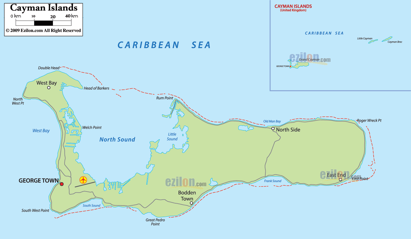
The Cayman Islands, a three-island archipelago in the Caribbean Sea, is a popular destination for tourists, divers, and sunbathers. With its crystal-clear waters and stunning landscapes, the islands are a paradise for those who seek the ultimate island experience. To help you plan your trip, this Cayman Islands map shows the settlements, seaports, bays, islands, points, harbors, and international airports that make up the country. In addition, the map features satellite imagery to provide a unique view of the country.
The Cayman Islands are made up of three islands: Grand Cayman, Little Cayman, and Cayman Brac. Grand Cayman is the largest of the three and is home to the capital city, George Town. It’s also home to some of the best beaches in the Caribbean, making it the perfect destination for a relaxing beach holiday. Little Cayman and Cayman Brac are smaller and less populated, but still offer plenty to do and see. From snorkeling and diving to bird spotting and hiking, these two islands are sure to keep you entertained.
Whether you are looking for a beach holiday, an adventure-filled holiday, or simply a chance to relax, the Cayman Islands have something for everyone. With this Cayman Islands map, you can explore the islands and plan your trip with ease. From the settlements, seaports, bays, islands, points, harbors, and international airports to the satellite imagery, this map provides an in-depth view of the country.
Online Interactive Political Map
Click on ![]() to view map in "full screen" mode.
to view map in "full screen" mode.
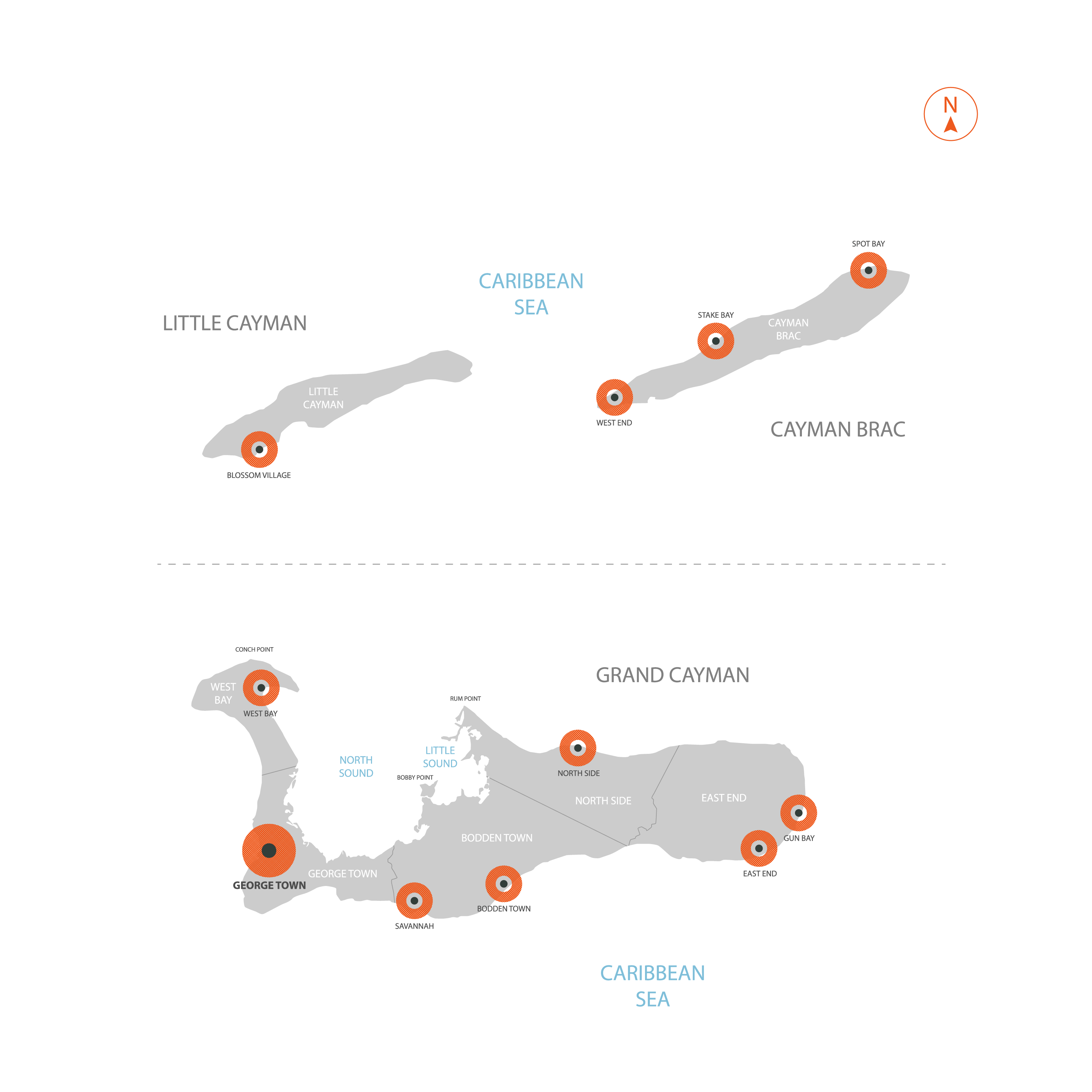
The British Overseas Territory of Cayman Islands is administratively divided into 6 districts. These districts are Bodden Town, Cayman Brac and Little Cayman, East End, George Town, North Side, and West Bay.
Covering an area of 264 sq. km, the three-island groups of Grand Cayman, Cayman Brac, and Little Cayman together form the territory of Cayman Islands. Located on the Grand Cayman island is George Town – the capital and the largest city of Cayman Islands. It is the administrative and financial servicing center of the island nation.
Location Maps
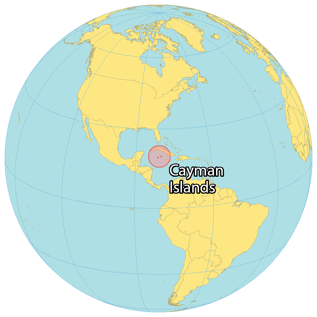
Where is Cayman Islands?
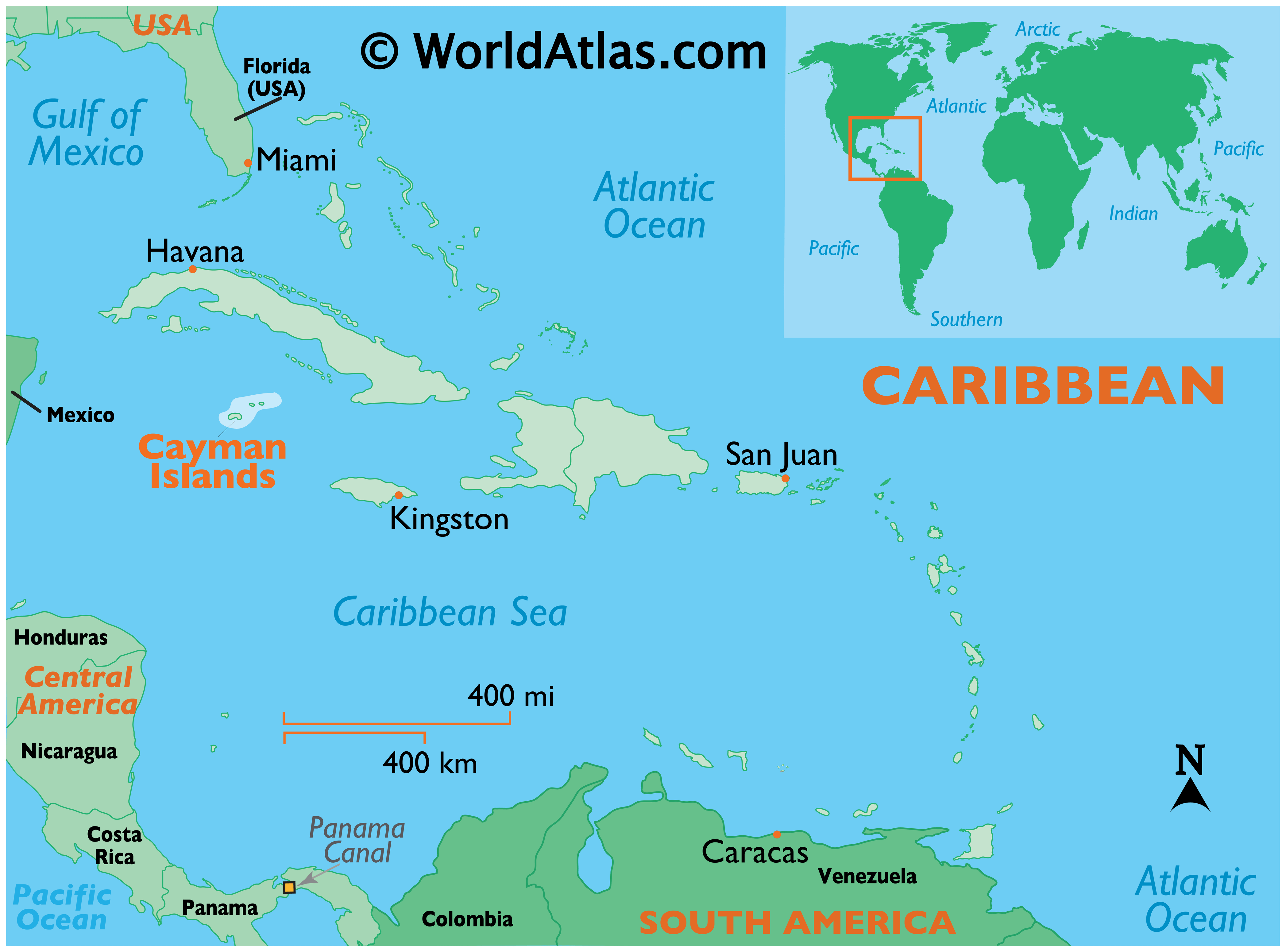
The Cayman Islands are a British Overseas Territory located in the Caribbean Sea. The territory occupies a total area of 264 square kilometers (102 sq mi), making it smaller than Dominica but larger than Bermuda. The country is situated in the Caribbean Sea to the south of Cuba and northeast of Honduras. The origin of Cayman Islands is from the Cayman Ridge, an undersea mountain range. The Bluff, a lower plateau on the island of Cayman Brac, is the highest point of the Cayman Islands at 43 meters (141 ft). The terrain of the Cayman Islands is mostly low-lying and has a tropical wet and dry climate. The two main drivers of the economy in the Cayman Islands are financial services and tourism.

High Definition Political Map of Cayman Islands
History
No evidence of an indigenous people has been found on the Cayman Islands. It is believed that they were discovered by Christopher Columbus on 10 May 1503 during his final voyage to the Americas. He named them ‘Las Tortugas’ after the large number of turtles found there (which were soon hunted to near-extinction); however, in the succeeding decades the islands began to be referred to as Caimanas or Caymanes, after the caimans present there. No immediate colonisation followed Columbus’s discovery, but a variety of settlers from various backgrounds eventually came, including pirates, shipwrecked sailors, and deserters from Oliver Cromwell’s army in Jamaica. Sir Francis Drake briefly visited the islands in 1586.
The first recorded permanent inhabitant, Isaac Bodden, was born on Grand Cayman around 1661. He was the grandson of an original settler named Bodden, probably one of Oliver Cromwell’s soldiers at the taking of Jamaica in 1655.
England took formal control of the Cayman Islands, along with Jamaica, as a result of the Treaty of Madrid of 1670. That same year saw an attack on a turtle fishing settlement on Little Cayman by the Spanish under Manuel Ribeiro Pardal. Following several unsuccessful attempts at settlement in what had by now become a haven for pirates, a permanent English-speaking population in the islands dates from the 1730s. With settlement, after the first royal land grant by the Governor of Jamaica in 1734, came the perceived need for slaves. Many were brought to the islands from Africa; this is evident today with the majority of native Caymanians being of African and/or English descent. The results of the first census taken in the islands in 1802 showed the population on Grand Cayman to be 933, with 545 of those inhabitants being enslaved. Slavery was abolished in the Cayman Islands in 1833. At the time of abolition, there were over 950 people of African ancestry enslaved by 116 families.
On 22 June 1863, the Cayman Islands became officially declared and administered as a dependency of the Crown Colony of Jamaica. The islands continued to be governed as part of the Colony of Jamaica until 1962 when they became a separate Crown colony while Jamaica became an independent Commonwealth realm.
On 8 February 1794, the Caymanians rescued the crews of a group of ten merchant ships, including HMS Convert, an incident that has since become known as the Wreck of the Ten Sail. The ships had struck a reef and run aground during rough seas. Legend has it that King George III rewarded the island with a promise never to introduce taxes as compensation for their generosity, as one of the ships carried a member of the King’s own family. While this remains a popular legend, the story is not true.
In the 1950s, tourism began to take off with the opening of Owen Roberts International Airport (ORIA) in 1952, a bank and several hotels, plus a number of scheduled flights and cruise stop-overs. Politically the Cayman Islands were an internally self-governing territory of Jamaica from 1958 to 1962; however, they reverted to direct British rule following the independence of Jamaica in 1962. In 1972, a large degree of internal autonomy was granted by a new constitution, with further revisions being made in 1994. The Cayman Islands government focused on boosting the territory’s economy via tourism and off-shore finance, both of which mushroomed from the 1970s onwards. The Cayman Islands have historically been a tax-exempt destination, and the government has always relied on indirect and not direct taxes. The territory has never levied income tax, capital gains tax, or any wealth tax, making them a popular tax haven.
In April 1986, the first marine protected areas were designated in the Cayman Islands, making them the first islands in the Caribbean to protect its fragile marine life.
The constitution was further modified in 2001 and 2009, codifying various aspects of human rights legislation.
On 11 September 2004 the island of Grand Cayman, which lies largely unprotected at sea level, was hit by Hurricane Ivan, creating an 8-foot (2.4 m) storm surge which flooded many areas of Grand Cayman. An estimated 83% of the dwellings on the island were damaged including 4% requiring complete reconstruction. A reported 70% of all dwellings suffered severe damage from flooding or wind. Another 26% sustained minor damage from partial roof removal, low levels of flooding, or impact with floating or wind-driven hurricane debris. Power, water and communications were disrupted for months in some areas as Ivan was the worst hurricane to hit the islands in 86 years. Grand Cayman began a major rebuilding process and within two years its infrastructure was nearly returned to pre-hurricane status. Due to the tropical location of the islands, more hurricanes or tropical systems have affected the Cayman Islands than any other region in the Atlantic basin; it has been brushed or directly hit, on average, every 2.23 years.
Physical Map of Cayman Islands
Geography
The islands are in the western Caribbean Sea and are the peaks of an undersea mountain range called the Cayman Ridge (or Cayman Rise). This ridge flanks the Cayman Trough, 6,000 m (20,000 ft) deep which lies 6 km (3.7 mi) to the south. The islands lie in the northwest of the Caribbean Sea, east of Quintana Roo, Mexico and Yucatán State, Mexico, northeast of Costa Rica, north of Panama, south of Cuba and west of Jamaica. They are situated about 700 km (430 mi) south of Miami, 750 km (470 mi) east of Mexico, 366 km (227 mi) south of Cuba, and about 500 km (310 mi) northwest of Jamaica. Grand Cayman is by far the largest, with an area of 197 km (76 sq mi). Grand Cayman’s two “sister islands”, Cayman Brac and Little Cayman, are about 120 km (75 mi) east north-east of Grand Cayman and have areas of 38 and 28.5 km (14.7 and 11.0 sq mi) respectively. The nearest land mass from Grand Cayman is the Canarreos Archipelago (about 240 km or 150 miles away), whereas the nearest from the easternmost island Cayman Brac is the Jardines de la Reina archipelago (about 160 km or 100 miles away) – both of which are part of Cuba.
All three islands were formed by large coral heads covering submerged ice-age peaks of western extensions of the Cuban Sierra Maestra range and are mostly flat. One notable exception to this is The Bluff on Cayman Brac’s eastern part, which rises to 43 m (141 ft) above sea level, the highest point on the islands.
The terrain is mostly a low-lying limestone base surrounded by coral reefs. The portions of prehistoric coral reef that line the coastline and protrude from the water are referred to as ironshore.
Fauna
The mammalian species in the Cayman Islands include the introduced Central American agouti and eight species of bats. At least three now extinct native rodent species were present until the discovery of the islands by Europeans. Marine life around the island of the Grand Cayman includes tarpon, silversides (Atheriniformes), French angelfish (Pomacanthus paru), and giant barrel sponges. A number of cetaceans are found in offshore waters. These species include the goose-beaked whale (Ziphius cavirostris), Blainville’s beaked whale (Mesoplodon densirostris) and sperm whale (Physeter macrocephalus).
Cayman avian fauna includes two endemic subspecies of Amazona parrots: Amazona leucocephala hesterna or Cuban amazon, presently restricted to the island of Cayman Brac, but formerly also on Little Cayman, and Amazona leucocephala caymanensis or Grand Cayman parrot, which is native to the Cayman Islands, forested areas of Cuba, and the Isla de la Juventud. Little Cayman and Cayman Brac are also home to red-footed and brown boobies. Although the barn owl (Tyto alba) occurs in all three of the islands they are not commonplace. The Cayman Islands also possess five endemic subspecies of butterflies. These butterfly breeds can be viewed at the Queen Elizabeth II Botanic Park on the Grand Cayman.
Among other notable fauna at the Queen Elizabeth II Botanic Park is the critically threatened blue iguana which is also known as the Grand Cayman iguana (Cyclura lewisi). The blue iguana is endemic to the Grand Cayman particularly because of rocky, sunlit, open areas near the island’s shores that are advantageous for the laying of eggs. Nevertheless, habitat destruction and invasive mammalian predators remain the primary reasons that blue iguana hatchlings do not survive naturally.
The Cuban crocodile (Crocodylus rhombifer) once inhabited the islands. The name “Cayman” is derived from a Carib word for various crocodilians.
Climate
The Cayman Islands has a tropical wet and dry climate, with a wet season from May to October, and a dry season that runs from November to April. Seasonally, there is little temperature change.
A major natural hazard is the tropical cyclones that form during the Atlantic hurricane season from June to November.
On 11 and 12 September 2004, Hurricane Ivan struck the Cayman Islands. The storm resulted in two deaths and caused significant damage to the infrastructure on the islands. The total economic impact of the storms was estimated to be $3.4 billion.