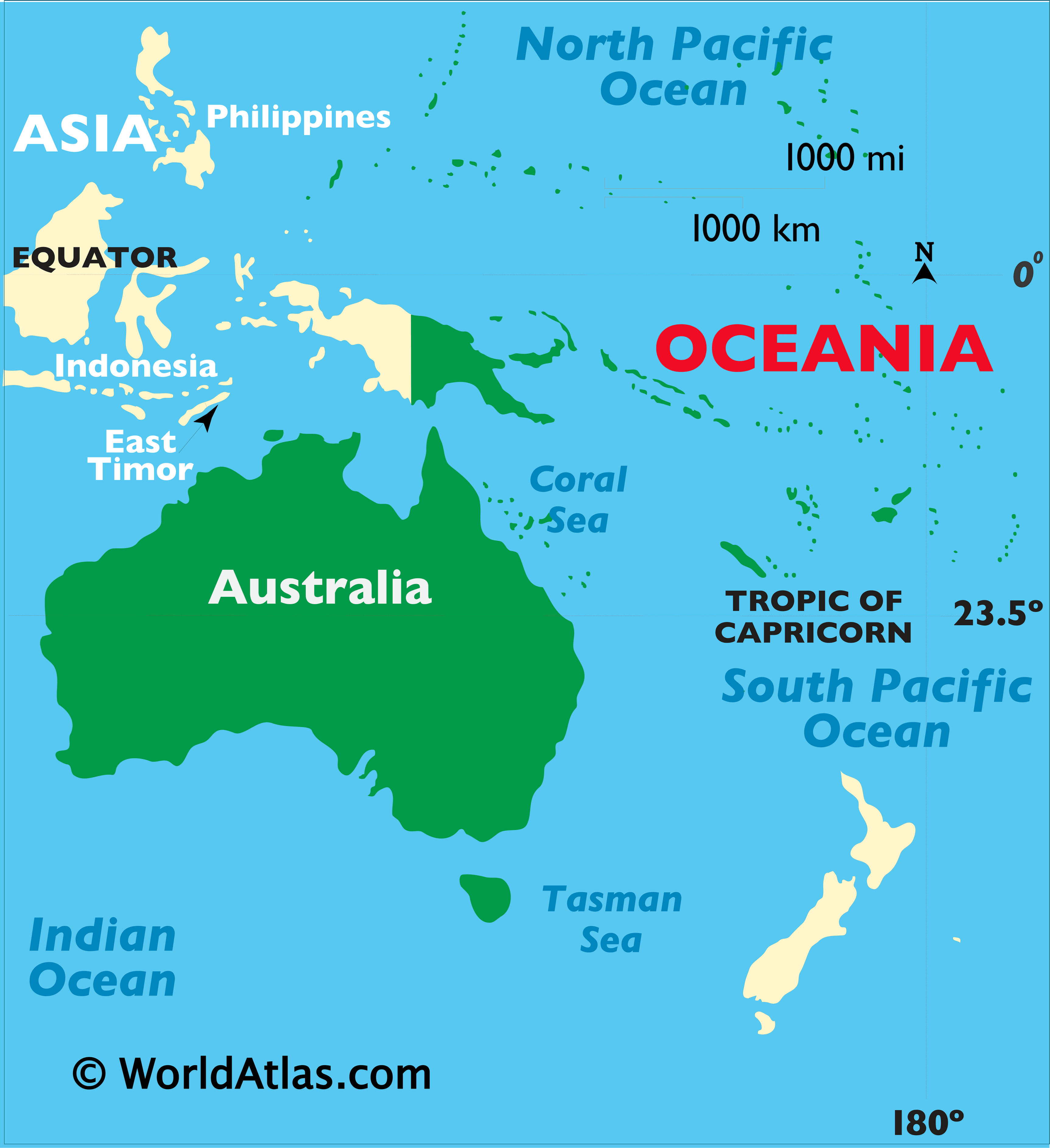
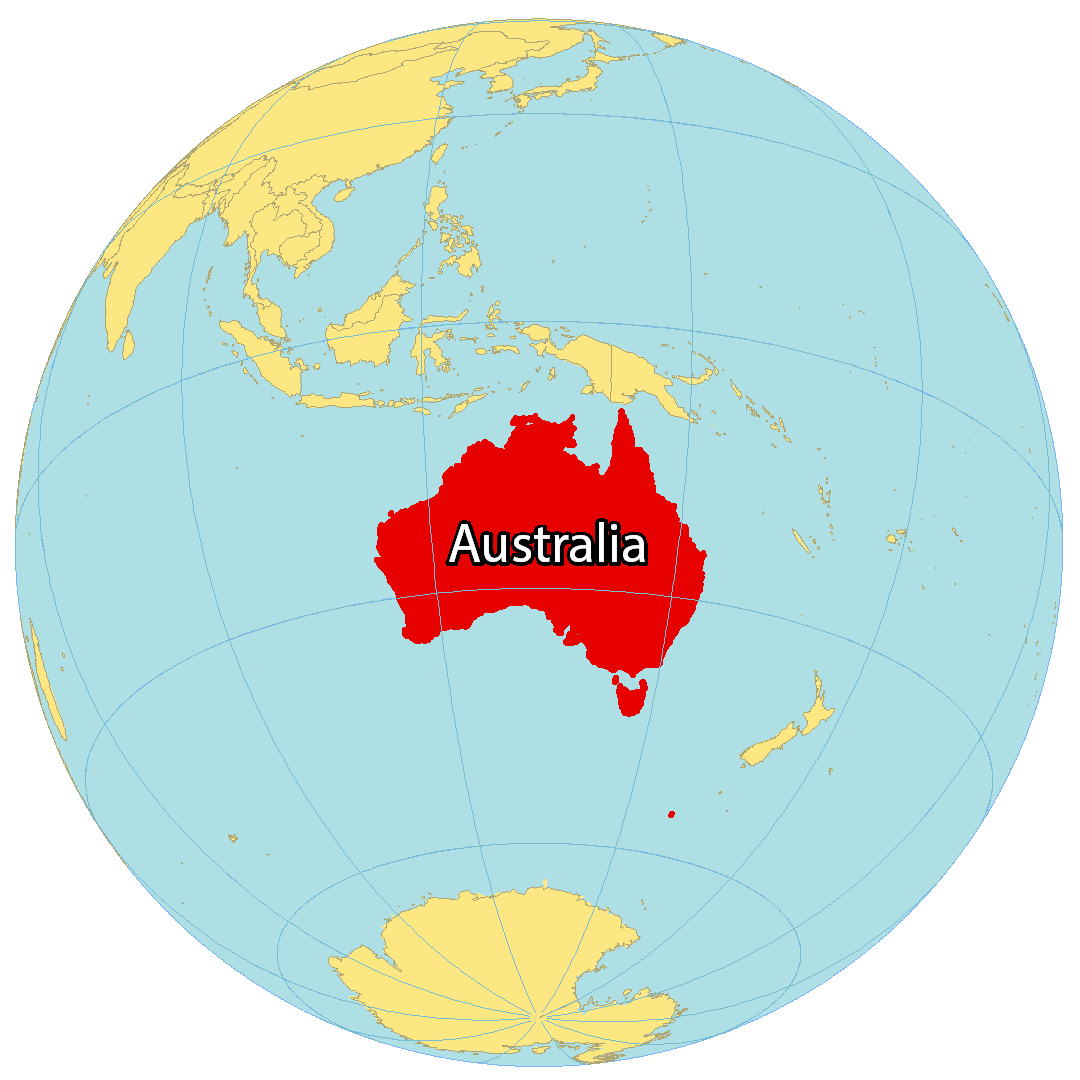
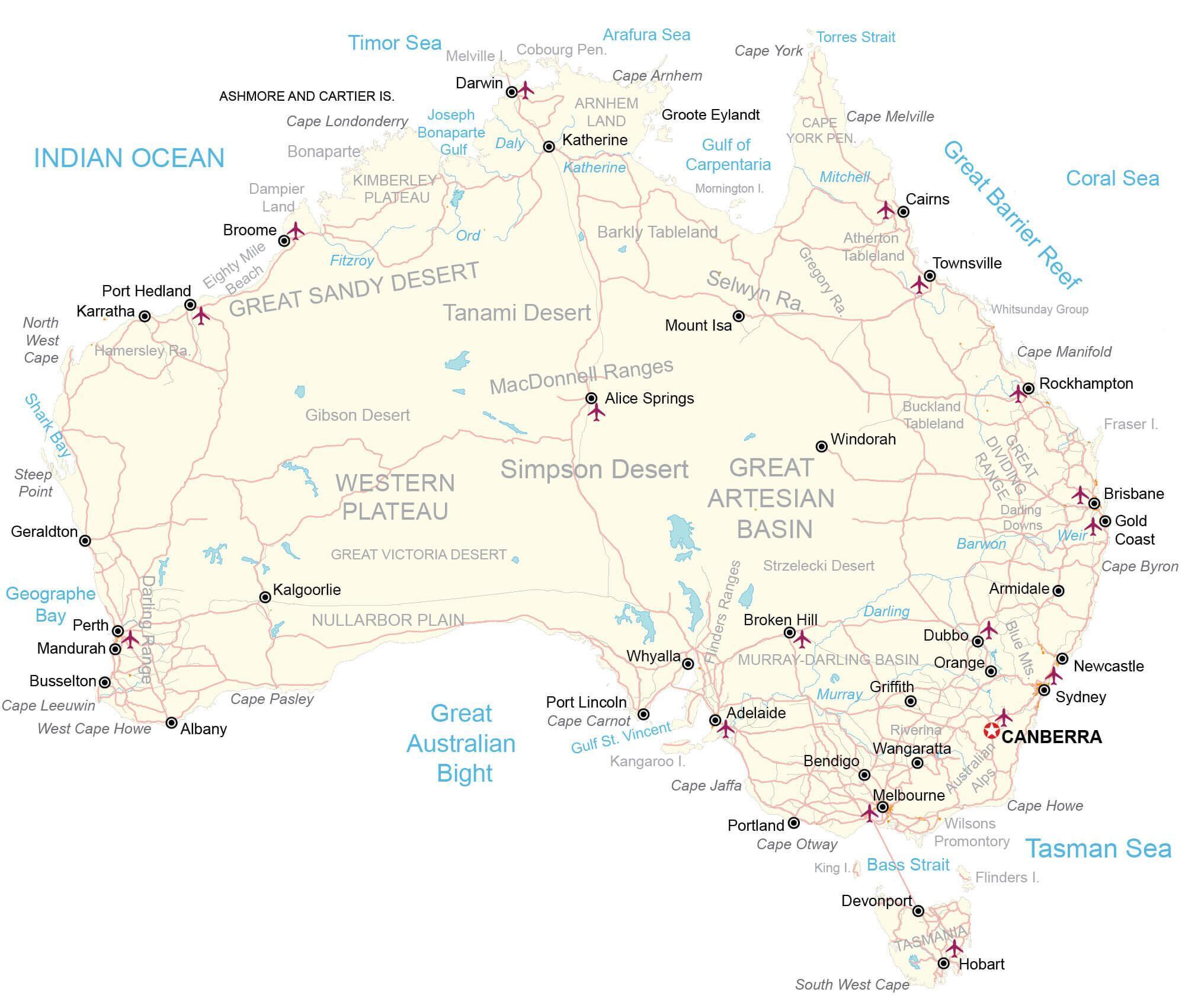
Covering an area of 7,617,930 sq.km (2,969,907 sq mi), Australia is the smallest continent, the world’s 6th largest country and the largest country in Oceania. It is located between the Indian and Pacific Oceans in the Southern hemisphere.
Australia is extremely dry, with about 35% of the country receiving very little rain (if any). Almost 20% of available land is dominated by deserts and semi-arid land, located along the Tropic of Capricorn.
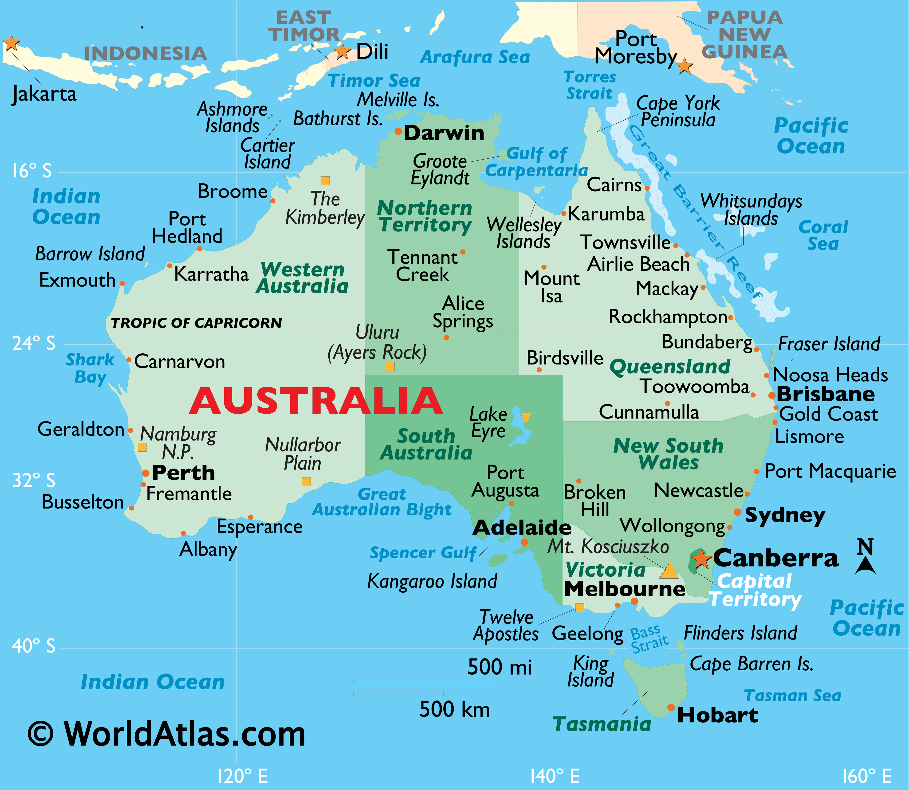
Ayers Rock (Uluru): Considered the largest solitary rock on the planet, its red sandstone surface smoothed by high winds over time is revered as a holy place and called Uluru by the aboriginal people. It’s 1,143ft (348m) high and is located in the semi-arid region of Central Australia.
At the northernmost point of Queensland is Cape York Peninsula, described as the world’s “last wilderness”, and as one of the “wildest unexplored wilderness area on the planet”. Cape York is home to jagged-tooth mountains, tropical rainforests, extensive mangrove forests, grasslands, swamps and fast-moving rivers.
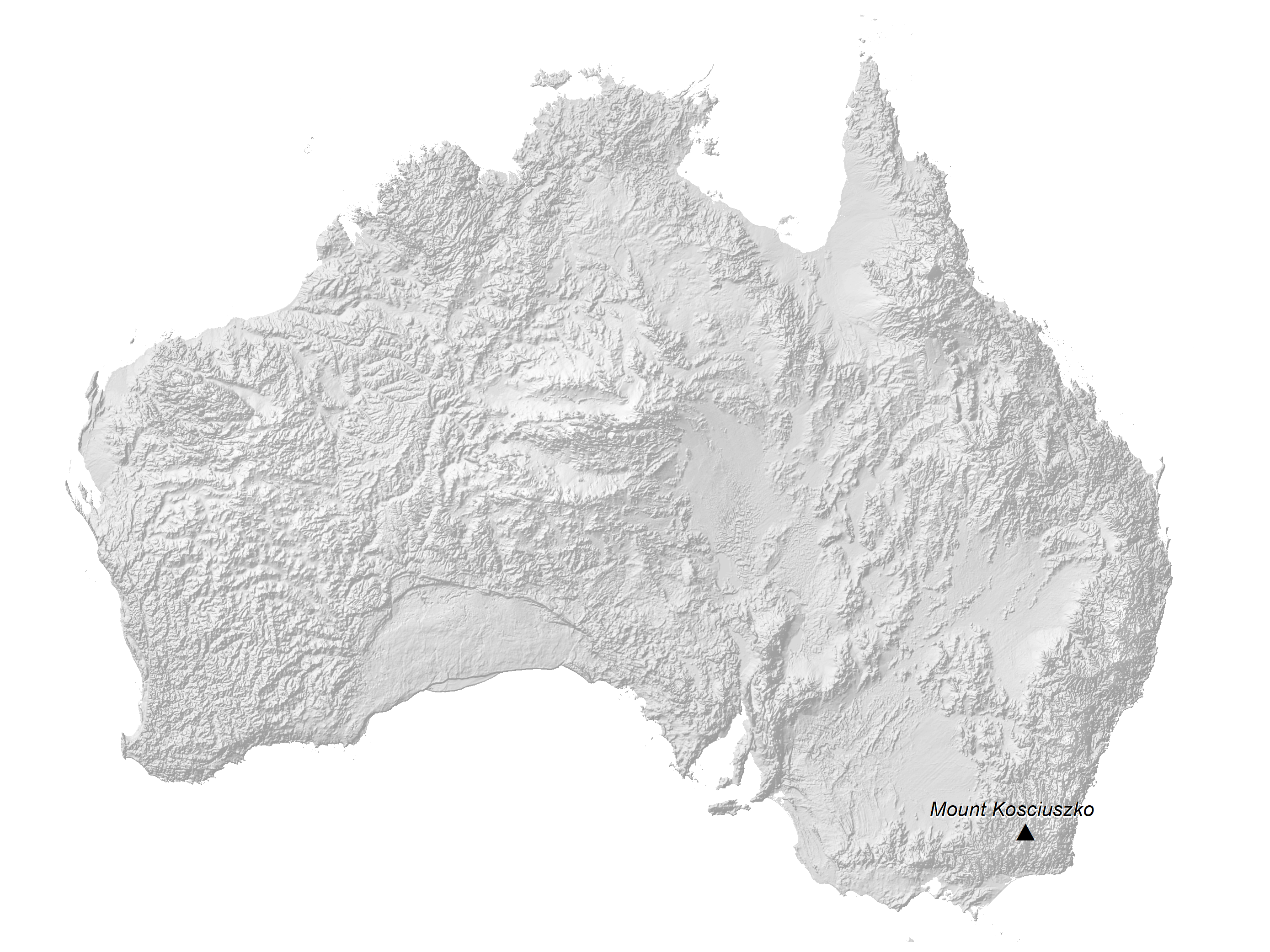
The Great Dividing Mountain Range extends from Melbourne (in the south) to Cape York (in the north). Located in New South Wales, in the south eastern part of the country is, Mount Kosciuszko, the highest point in the Australian mainland, at an elevation of 7,312ft (2,229m) (as marked on the map by an upright yellow triangle). The lowest point is located in South Australia in the dry bed of Lake Eyre at -49ft (-15m) below sea level.
Darling/Murray River System: The Darling River, 1,160 miles (1,879km) in length, flows southwest from the edges of the Great Dividing Range into the Murray River. The Murray rises in the Australian Alps and flows 1,200 miles (1,930km) to the Spencer Gulf, directly west of Adelaide. It’s the longest river in Australia and is a vital source of irrigation for the country’s major agricultural industries.
Darling Range: This low mountain range runs through far southwestern Australia. Its highest point is Mt. Cooke at 1,910ft (580m).
The Great Barrier Reef: It extends for about 1600 miles off the north eastern coast of Australia.
Fraser Island: Located along Australia’s coral sea coastline, to the north of Brisbane (and not shown on this map), Fraser Island is Australia’s 4th largest island (after Tasmania, Melville Island and Kangaroo Island), and the largest sand island in the world. Created by the action of wind over thousands of years, the island is 120km long and about 115km wide.
| Flag: |  |
|---|---|
| Legal Name: | Commonwealth of Australia |
| Capital Value: | Canberra |
| Official languages: | None at the federal level |
| Demonym(s): |
|
| Government: | Federal parliamentary constitutional monarchy |
| Legislature: | Parliament |
| Total Area: | 7,741,220 km² |
| Land Area: | 7,682,300 km² |
| Water Area: | 58,920 km² |
| Population: | 25,364,307 |
| Density: | 3.4/km (8.8/sq mi) (192nd) |
| GDP: | $1.39 Trillion |
| GDP Per Capita: | $54,907.10 |
| Currency Value: | Australian dollars (AUD) |
| Driving side: | left |
| Calling code: | +61 |
| Internet TLD: | .au |
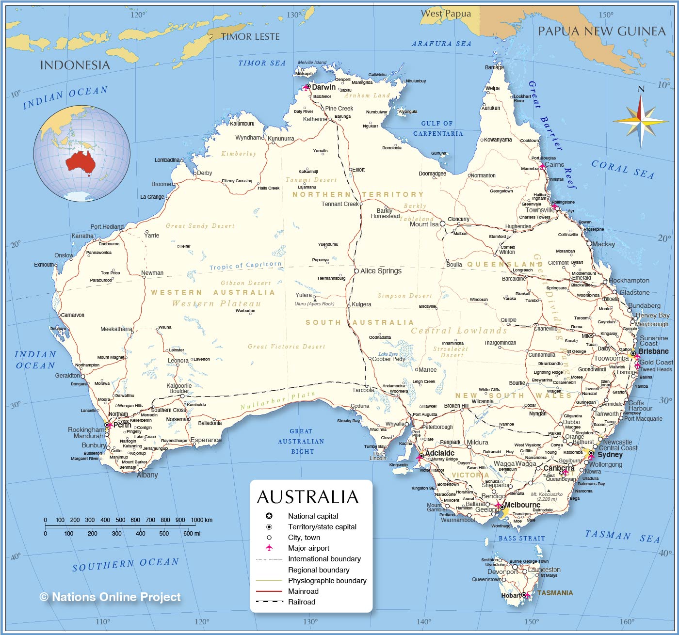
Explore the stunning topography of Australia with this interactive map. It features major cities, roads, and reference features and highlights the country’s diverse landscapes such as its sandy deserts, shield plateau, and mountain ranges.
Location Maps
Where is Australia?
Australia is the largest country in Oceania and the sixth-largest country in the world. It’s the smallest continent on Earth, but it’s also too large to be an island. Australia is nicknamed the “Land Down Under” due to its location below the equator.
It includes the island state of Tasmania to the southeast, which is the 26th largest island in the world. Australia is bordered by Indonesia, East Timor, and Papua New Guinea to the north. Additionally, several islands are situated to the east such as New Caledonia, Vanuatu, and Fiji Islands. Finally, New Zealand is across from the Tasman Sea to the southeast.

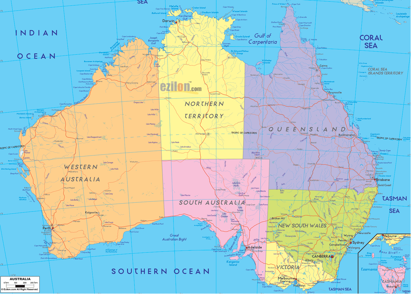
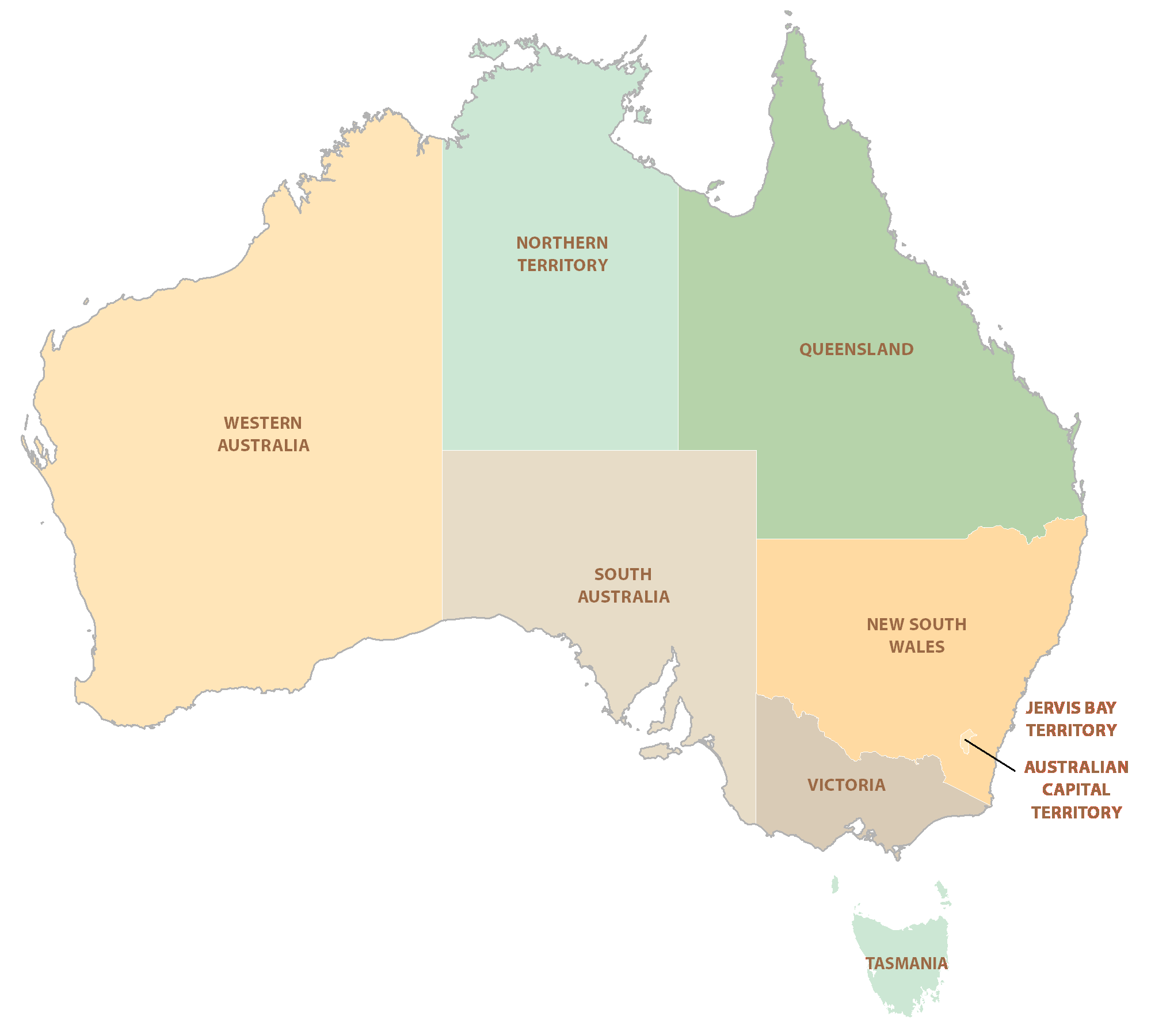
High Definition Political Map of Australia
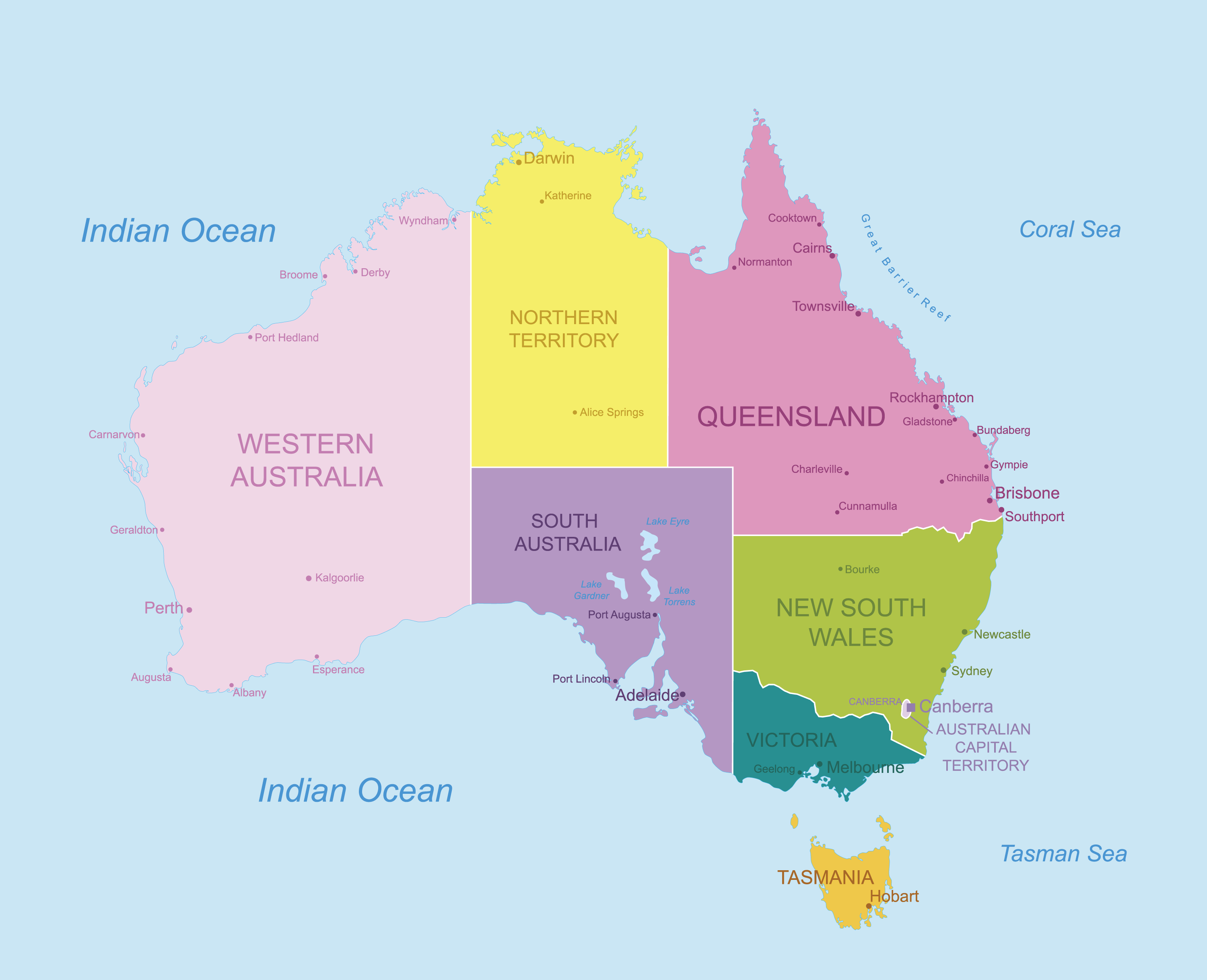
Australia Administrative Map
History
Indigenous peoples
Indigenous Australians comprise two groups: the Aboriginal peoples of the Australian mainland (and surrounding islands including Tasmania), and the Torres Strait Islanders, who are a distinct Melanesian people. Human habitation of the Australian continent is estimated to have begun 50,000 to 65,000 years ago, with the migration of people by land bridges and short sea crossings from what is now Southeast Asia. It is uncertain how many waves of immigration may have contributed to these ancestors of modern Aboriginal Australians. The Madjedbebe rock shelter in Arnhem Land is recognised as the oldest site showing the presence of humans in Australia. The oldest human remains found are the Lake Mungo remains, which have been dated to around 41,000 years ago.
Aboriginal Australian culture is one of the oldest continuous cultures on Earth. At the time of first European contact, Aboriginal Australians were complex hunter-gatherers with diverse economies and societies and about 250 different language groups. Recent archaeological finds suggest that a population of 750,000 could have been sustained. Aboriginal Australians have an oral culture with spiritual values based on reverence for the land and a belief in the Dreamtime.
The Torres Strait Islander people first settled their islands around 4000 years ago. Culturally and linguistically distinct from mainland Aboriginal peoples, they were seafarers and obtained their livelihood from seasonal horticulture and the resources of their reefs and seas.
European exploration and colonisation
The northern coasts and waters of Australia were visited sporadically for trade by Makassan fishermen from what is now Indonesia. The first recorded European sighting of the Australian mainland, and the first recorded European landfall on the Australian continent, are attributed to the Dutch. The first ship and crew to chart the Australian coast and meet with Aboriginal people was the Duyfken captained by Dutch navigator, Willem Janszoon. He sighted the coast of Cape York Peninsula in early 1606, and made landfall on 26 February 1606 at the Pennefather River near the modern town of Weipa on Cape York. Later that year, Spanish explorer Luís Vaz de Torres sailed through and navigated the Torres Strait Islands. The Dutch charted the whole of the western and northern coastlines and named the island continent “New Holland” during the 17th century, and although no attempt at settlement was made, a number of shipwrecks left men either stranded or, as in the case of the Batavia in 1629, marooned for mutiny and murder, thus becoming the first Europeans to permanently inhabit the continent. In 1770, Captain James Cook sailed along and mapped the east coast, which he named “New South Wales” and claimed for Great Britain.
Following the loss of its American colonies in 1783, the British Government sent a fleet of ships, the First Fleet, under the command of Captain Arthur Phillip, to establish a new penal colony in New South Wales. A camp was set up and the Union Flag raised at Sydney Cove, Port Jackson, on 26 January 1788, a date which later became Australia’s national day. Most early convicts were transported for petty crimes and assigned as labourers or servants to “free settlers” (non-convict immigrants). While the majority of convicts settled into colonial society once emancipated, convict rebellions and uprisings were also staged, but invariably suppressed under martial law. The 1808 Rum Rebellion, the only successful armed takeover of government in Australia, instigated a two-year period of military rule. The following decade, social and economic reforms initiated by Governor Lachlan Macquarie saw New South Wales transition from a penal colony to a civil society.
The indigenous population declined for 150 years following settlement, mainly due to infectious disease. Thousands more died as a result of frontier conflict with settlers.
Colonial expansion
The British continued to push into other areas of the continent in the early 19th century, initially along the coast. In 1803, a settlement was established in Van Diemen’s Land (present-day Tasmania), and in 1813, Gregory Blaxland, William Lawson and William Wentworth crossed the Blue Mountains west of Sydney, opening the interior to European settlement. The British claim extended to the whole Australian continent in 1827 when Major Edmund Lockyer established a settlement on King George Sound (modern-day Albany). The Swan River Colony (present-day Perth) was established in 1829, evolving into the largest Australian colony by area, Western Australia. In accordance with population growth, separate colonies were carved from New South Wales: Tasmania in 1825, South Australia in 1836, New Zealand in 1841, Victoria in 1851, and Queensland in 1859. South Australia was founded as a “free province” — it was never a penal colony. Western Australia was also founded “free” but later accepted transported convicts, the last of which arrived in 1868, decades after transportation had ceased to the other colonies.
In 1823, a Legislative Council nominated by the governor of New South Wales was established, together with a new Supreme Court, thus limiting the powers of colonial governors. Between 1855 and 1890, the six colonies individually gained responsible government, thus becoming elective democracies managing most of their own affairs while remaining part of the British Empire. The Colonial Office in London retained control of some matters, notably foreign affairs and defence.
In the mid-19th century, explorers such as Burke and Wills went further inland to determine its agricultural potential and answer scientific questions. A series of gold rushes beginning in the early 1850s led to an influx of new migrants from China, North America and continental Europe, as well as outbreaks of bushranging and civil unrest; the latter peaked in 1854 when Ballarat miners launched the Eureka Rebellion against gold license fees.
From 1886, Australian colonial governments began introducing policies resulting in the removal of many Aboriginal children from their families and communities (referred to as the Stolen Generations).
Federation to the World Wars
On 1 January 1901, federation of the colonies was achieved after a decade of planning, constitutional conventions and referendums, resulting in the establishment of the Commonwealth of Australia as a nation and the entering into force of the Australian Constitution.
After the 1907 Imperial Conference, Australia and several other self-governing British settler colonies were given the status of self-governing “dominions” within the British Empire. Australia was one of the founding members of the League of Nations in 1920, and subsequently of the United Nations in 1945. Britain’s Statute of Westminster 1931 formally ended most of the constitutional links between Australia and the United Kingdom. Australia adopted it in 1942, but it was backdated to 1939 to confirm the validity of legislation passed by the Australian Parliament during World War II.
The Federal Capital Territory (later renamed the Australian Capital Territory) was formed in 1911 as the location for the future federal capital of Canberra. Melbourne was the temporary seat of government from 1901 to 1927 while Canberra was being constructed. The Northern Territory was transferred from the control of the South Australian government to the federal parliament in 1911. Australia became the colonial ruler of the Territory of Papua (which had initially been annexed by Queensland in 1883) in 1902 and of the Territory of New Guinea (formerly German New Guinea) in 1920. The two were unified as the Territory of Papua and New Guinea in 1949 and gained independence from Australia in 1975.
In 1914, Australia joined the Allies in fighting the First World War, and took part in many of the major battles fought on the Western Front. Of about 416,000 who served, about 60,000 were killed and another 152,000 were wounded. Many Australians regard the defeat of the Australian and New Zealand Army Corps (ANZACs) at Gallipoli in 1915 as the nation’s “baptism of fire” — its first major military action, with the anniversary of the landing at Anzac Cove commemorated each year on Anzac Day.
From 1939 to 1945, Australia joined the Allies in fighting the Second World War. Australia’s armed forces fought in the Pacific, European and Mediterranean and Middle East theatres. The shock of Britain’s defeat in Asia in 1942, followed soon after by the bombing of Darwin and other Japanese attacks on Australian soil, led to a widespread belief in Australia that a Japanese invasion was imminent, and a shift from the United Kingdom to the United States as Australia’s principal ally and security partner. Since 1951, Australia has been a formal military ally of the United States, under the ANZUS treaty.
Post-war and contemporary eras
In the decades following World War II, Australia enjoyed significant increases in living standards, leisure time and suburban development. Using the slogan “populate or perish”, the nation encouraged a large wave of immigration from across Europe, with such immigrants referred to as “New Australians”.
A member of the Western Bloc during the Cold War, Australia participated in the Korean War and the Malayan Emergency during the 1950s and the Vietnam War from 1962 to 1972. During this time, tensions over communist influence in society led to unsuccessful attempts by the Menzies Government to ban the Communist Party of Australia, and a bitter splitting of the Labor Party in 1955.
As a result of a 1967 referendum, the Federal Government received a mandate to implement policies to benefit Aboriginal people, and all Indigenous Australians were included in the Census. Traditional ownership of land (“native title”) was recognised in law for the first time when the High Court of Australia held in Mabo v Queensland (No 2) that the legal doctrine of terra nullius (“land belonging to no one”) did not apply to Australia at the time of European settlement.
Following the final abolition of the White Australia policy in 1973, Australia’s demography and culture transformed as a result of a large and ongoing wave of non-European immigration, mostly from Asia. The late 20th century also saw an increasing focus on foreign policy ties with other Pacific Rim nations. While the Australia Act 1986 severed the remaining vestigial constitutional ties between Australia and the United Kingdom, a 1999 referendum resulted in 55% of voters rejecting a proposal to abolish the Monarchy of Australia and become a republic.
Following the September 11 attacks on the United States, Australia joined the United States in fighting the Afghanistan War from 2001 to 2021 and the Iraq War from 2003 to 2009. The nation’s trade relations also became increasingly oriented towards East Asia in the 21st century, with China becoming the nation’s largest trading partner by a large margin.
During the COVID-19 pandemic which commenced in Australia in 2020, several of Australia’s largest cities were locked down for extended periods of time, and free movement across state borders was restricted in an attempt to slow the spread of the SARS-CoV-2 virus.
Physical Map of Australia

Australia Satellite Map
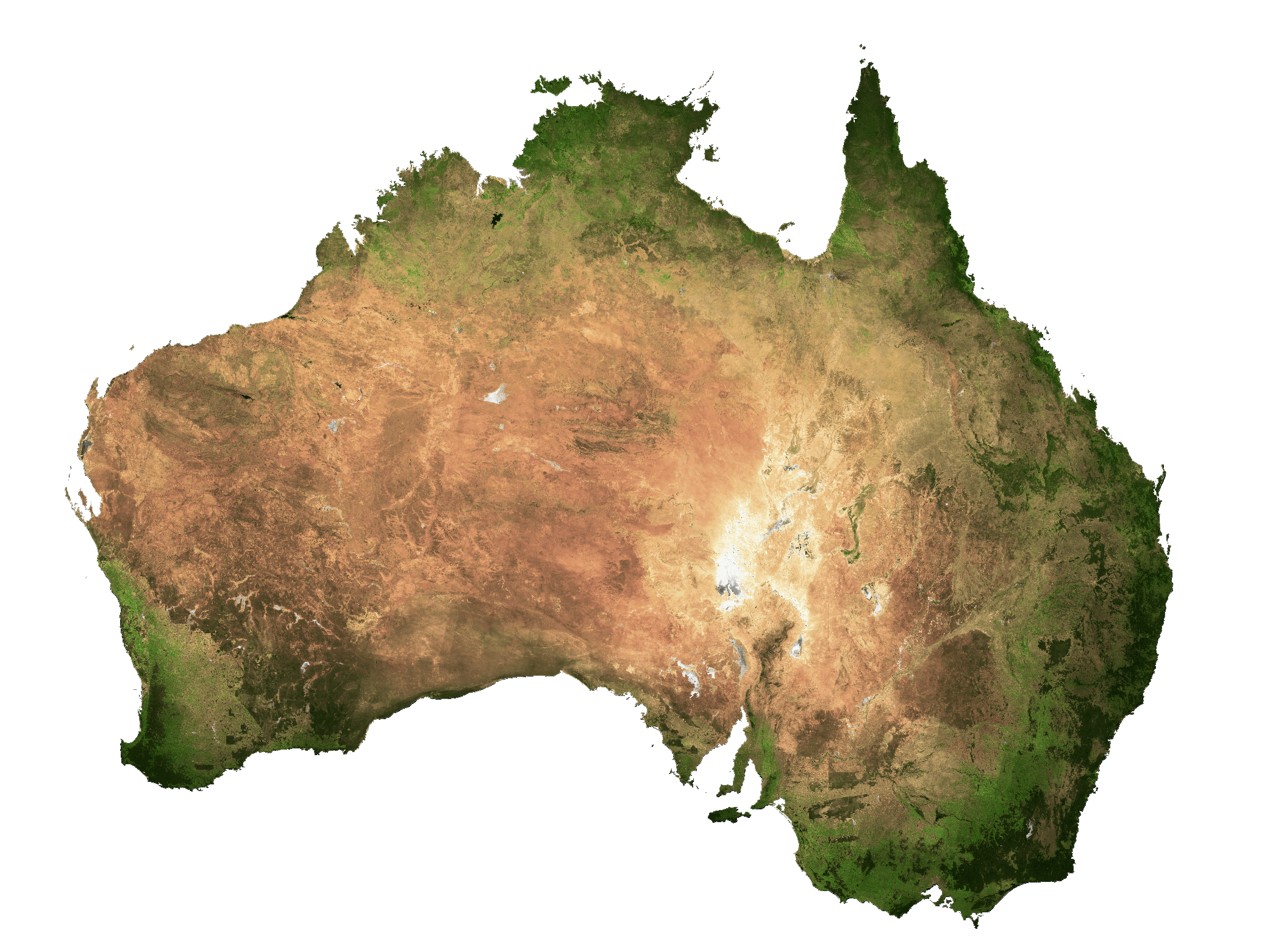
Elevation Map