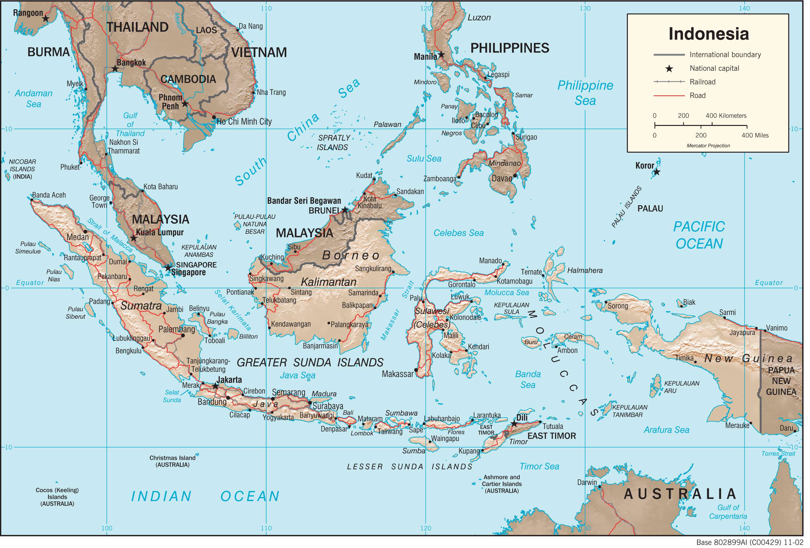
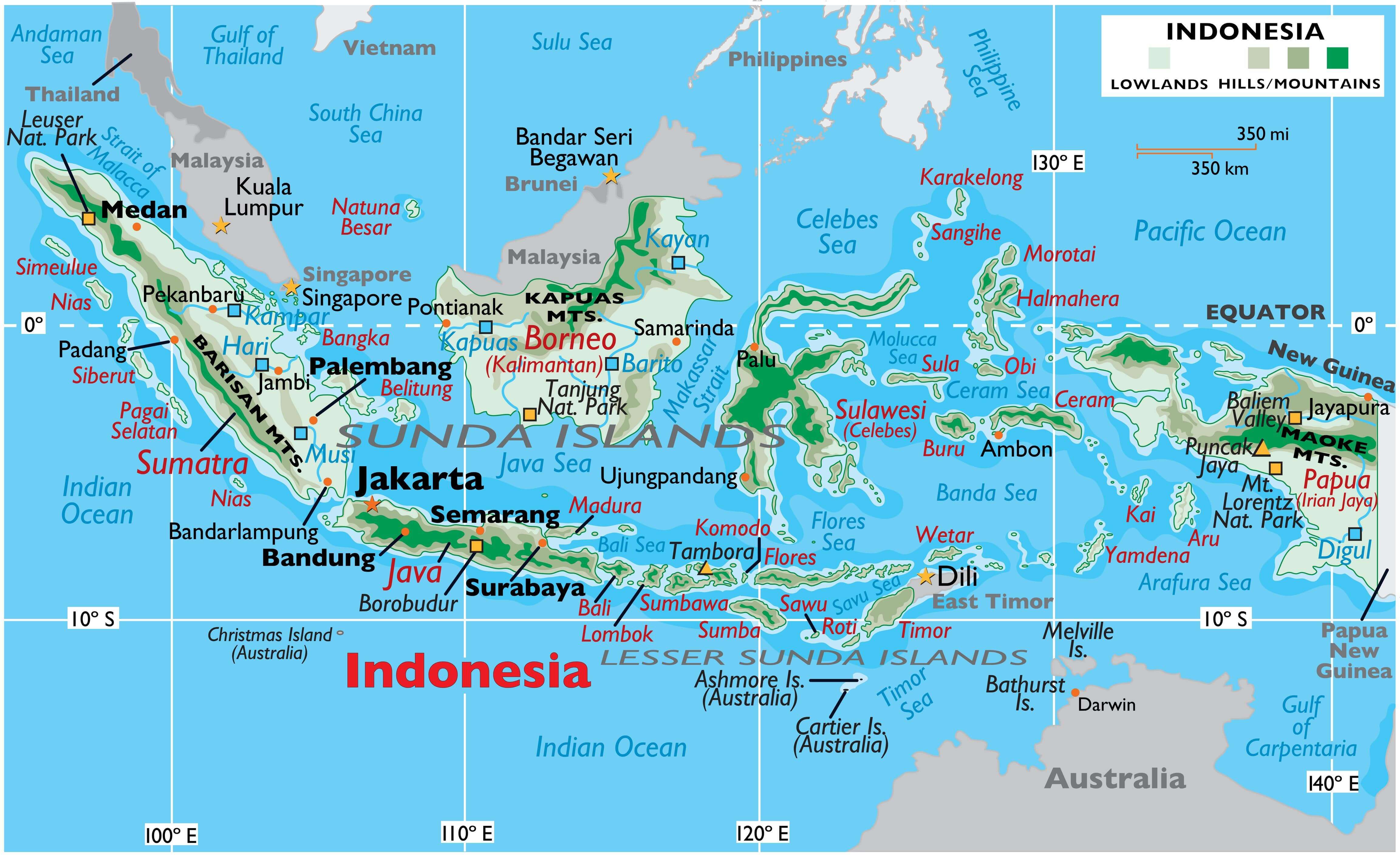
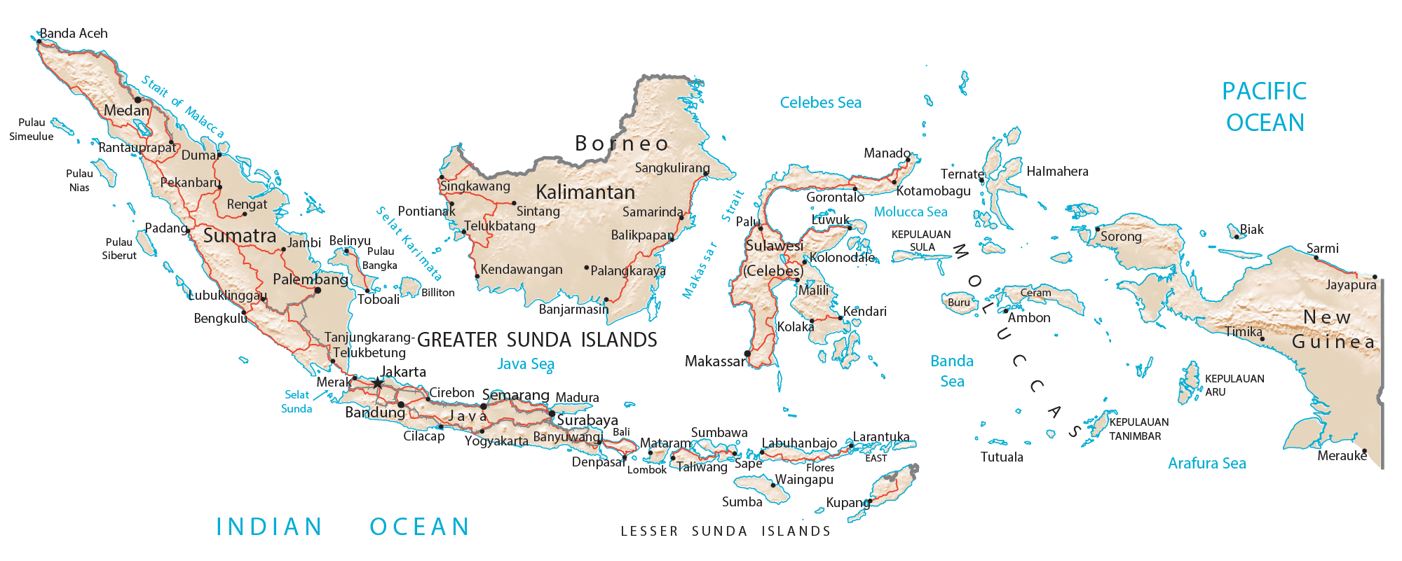
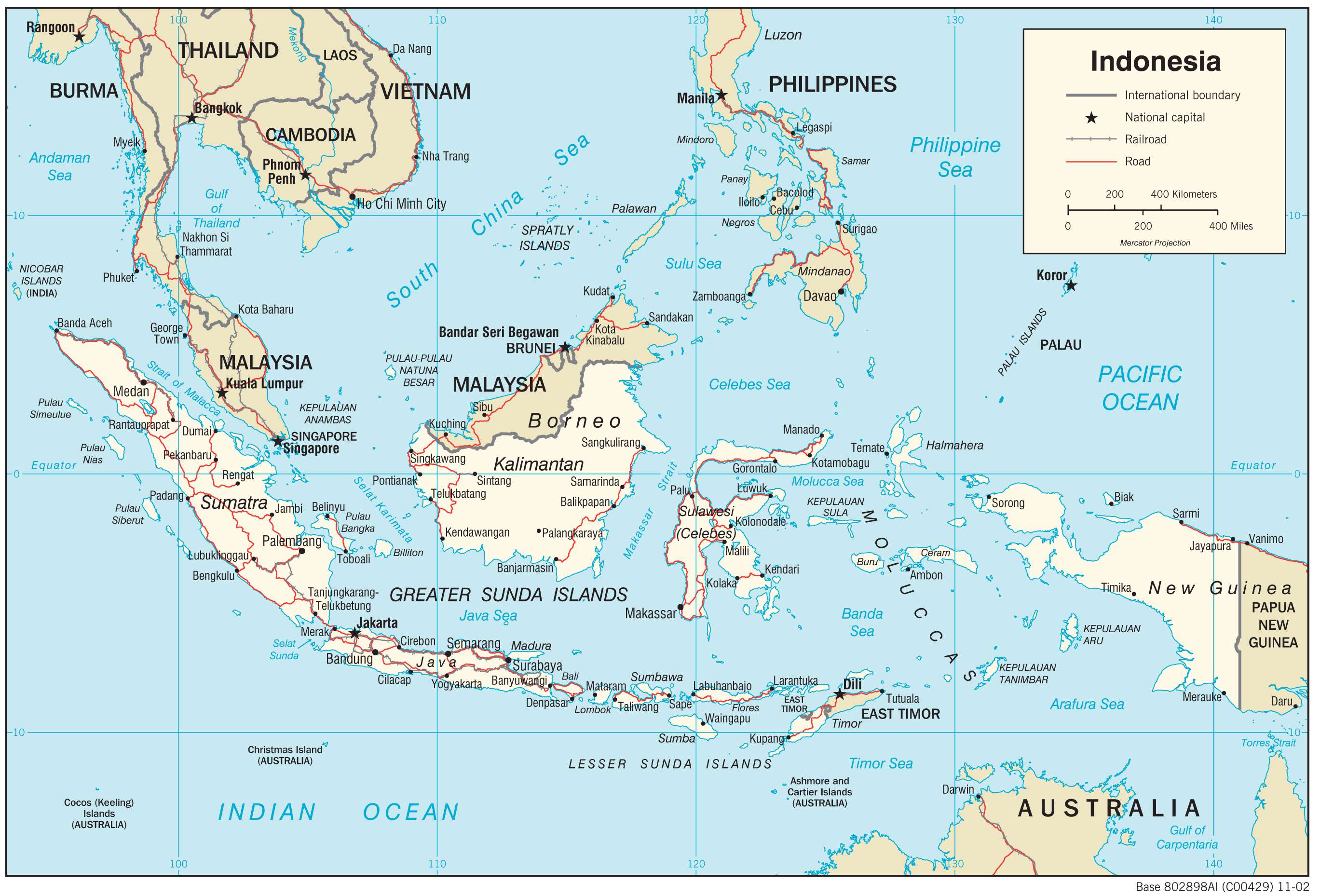
Covering an area of 1,904,569 sq. km, and strategically positioned between the Pacific and Indian Oceans, Indonesia comprises over 17,504 islands and is by far the largest and the most varied archipelago on Earth. Of these islands, the larger islands of Sumatra, Java, Kalimantan (which comprises two-thirds of the island of Borneo), Sulawesi, and Irian Jaya are quite mountainous, with some peaks reaching 12,000 ft. These mountains on the major Indonesian Islands are densely forested and volcanic in origin. The mountains with the highest elevations (over 16,000 ft) are found on Irian Jaya in the east.
Located in the Papua province and as a part of the Sudirman mountain range is Puncak Jaya – the highest point in Indonesia. At an elevation of 16,502 ft. (5,030 m) Puncak Jaya is also the world’s highest island peak and the Southwestern Pacific’s tallest mountain. The lowest point is the Indian Ocean (0m). Indonesia’s former tallest peak, Mount Tambora (8,930 ft, 2,722 m), is an active stratovolcano whose 1815 eruption was the largest ever in recorded history – killing nearly 71,000 people. The explosion alone was heard as far west as Sumatra island, some 1,200 miles (2,000 km) away, and ashfalls were recorded on the islands of Borneo, Sulawesi, Java, and Maluku.
In addition to the mountainous landscape, much of the islands as observed on the map, are covered in thick tropical rainforests that give way to coastal plains. The significant rivers of Indonesia include the Barito, Digul, Hari, Kampar, Kapuas, Kayan, and Musi. There are also some scattered inland lakes as well which are relatively small in size.
Due to its location along the south-western arm of the Ring of Fire, Indonesia has about 400 volcanoes within its borders, with at least 90 still active in some way. The most active volcanoes are Mount Kelud (which has erupted more than 30 times since 1000 AD) and Mount Merapi (which has erupted more than 80 times since 1000 AD) on Java island. For its location between numerous tectonic plates, including the two continental plates: the Eurasian Plate (Sunda Shelf) and the Australian Plate (Sahul Shelf), and two oceanic plates: the Philippine Sea Plate and Pacific Plate; natural disasters are common in Indonesia.
The most notable natural disaster is the 9.2 earthquake that struck in the Indian Ocean and which triggered the Tsunami of December 2004 and devastated many of the islands within Indonesia’s archipelago.
| Flag: |  |
|---|---|
| Legal Name: | Republic of Indonesia |
| Capital Value: | Jakarta |
| Demonym(s): | Indonesian |
| Government: | Unitary presidential republic |
| Legislature: | People’s Consultative Assembly (MPR) |
| Total Area: | 1,904,569 km² |
| Land Area: | 1,811,569 km² |
| Water Area: | 93,000 km² |
| Population: | 270,625,568 |
| Density: | 143/km (370.4/sq mi) (90th) |
| GDP: | $1.12 Trillion |
| GDP Per Capita: | $4,135.57 |
| Currency Value: | Indonesian rupiah (IDR) |
| Driving side: | left |
| Calling code: | +62 |
| Internet TLD: | .id |
Indonesia is a country filled with natural beauty, from its towering mountains to its tranquil coastal plains. View a satellite image of the country and explore the topography of its diverse terrain using a physical map. Discover the cities, towns, highways, and islands that make up this fascinating nation.
Online Interactive Political Map
Click on ![]() to view map in "full screen" mode.
to view map in "full screen" mode.
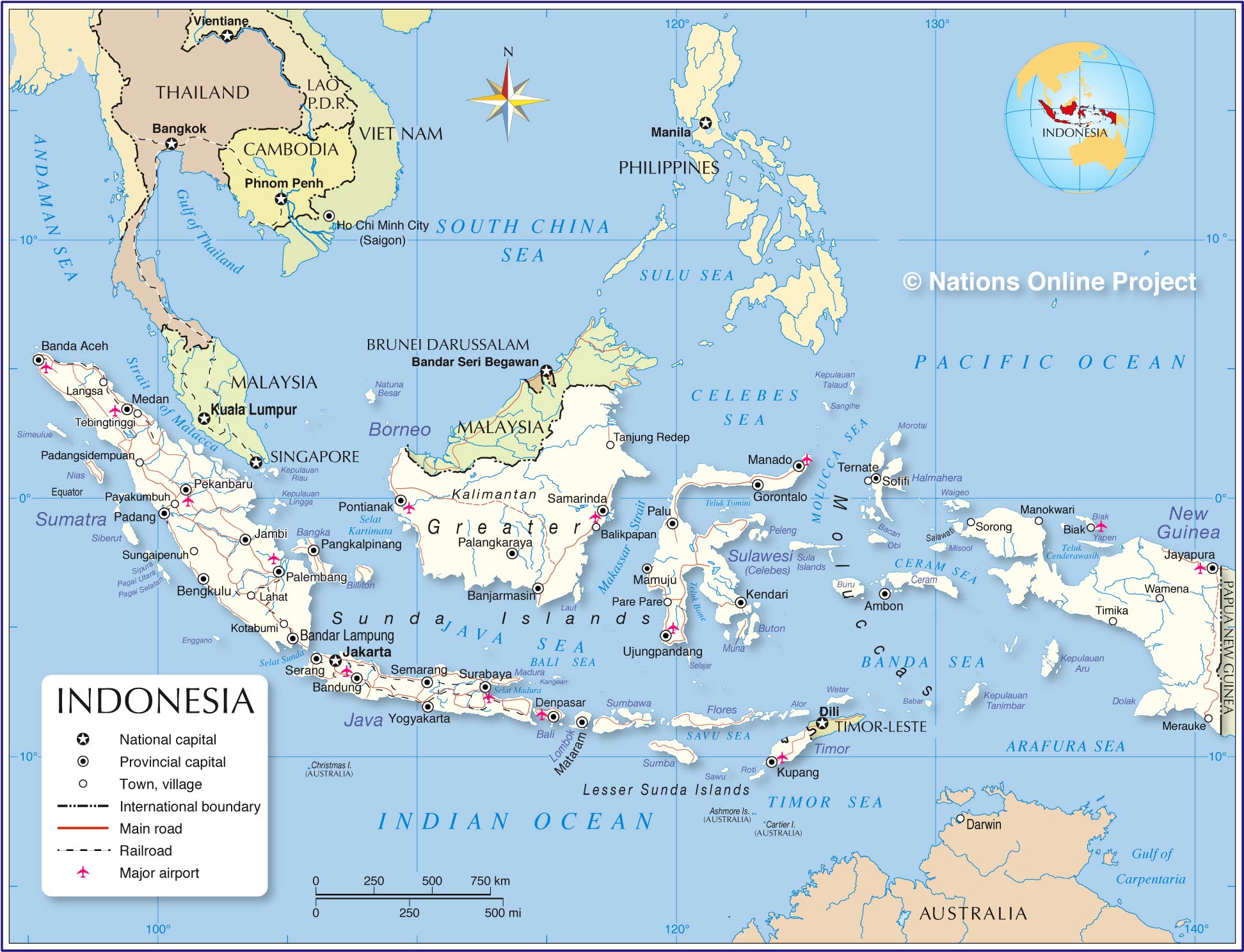
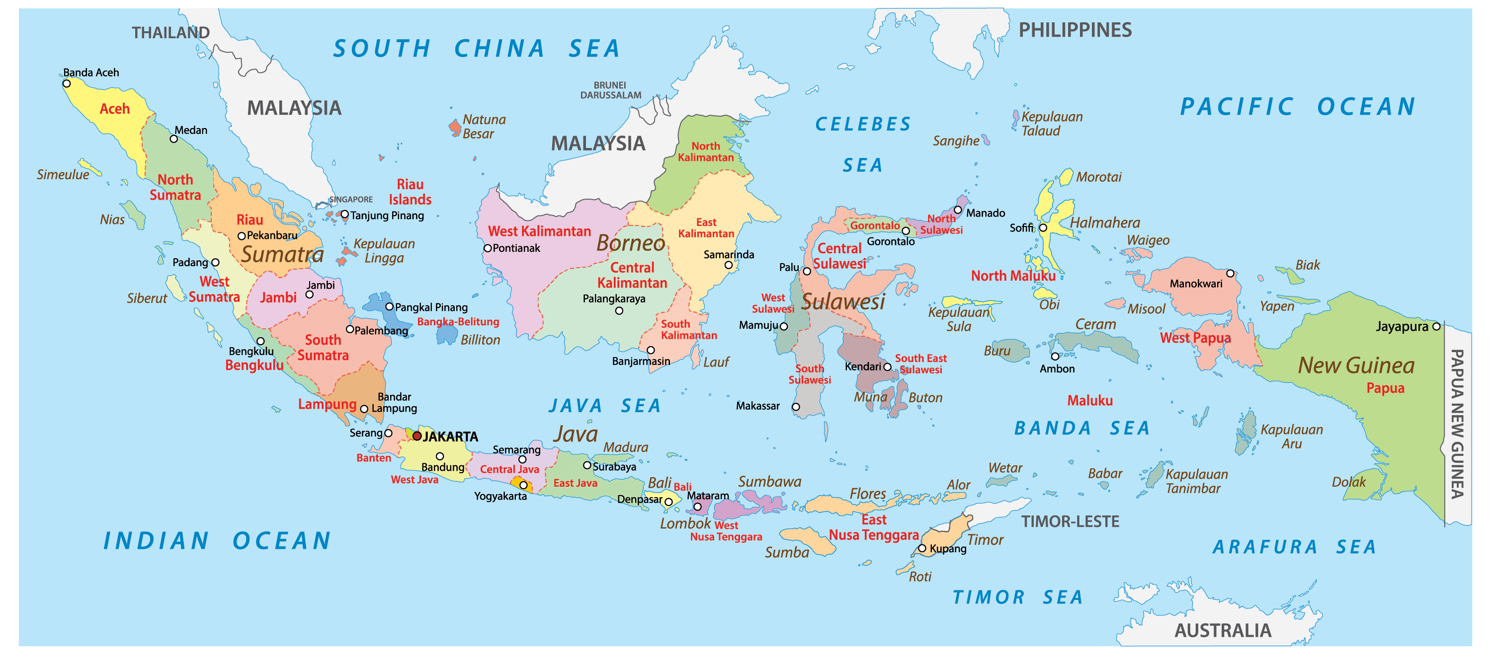
Indonesia is divided into 34 administrative provinces. These provinces are: Aceh, Bali, Banten, Bengkulu, Gorontalo, Jakarta, Jambi, Jawa Barat (West Java), Jawa Tengah (Central Java), Jawa Timur (East Java), Kalimantan Barat (West Kalimantan), Kalimantan Selatan (South Kalimantan), Kalimantan Tengah (Central Kalimantan), Kalimantan Timur (East Kalimantan), Kalimantan Utara (North Kalimantan), Kepulauan Bangka Belitung (Bangka Belitung Islands), Kepulauan Riau (Riau Islands), Lampung, Maluku, Maluku Utara (North Maluku), Nusa Tenggara Barat (West Nusa Tenggara), Nusa Tenggara Timur (East Nusa Tenggara), Papua, Papua Barat (West Papua), Riau, Sulawesi Barat (West Sulawesi), Sulawesi Selatan (South Sulawesi), Sulawesi Tengah (Central Sulawesi), Sulawesi Tenggara (Southeast Sulawesi), Sulawesi Utara (North Sulawesi), Sumatera Barat (West Sumatra), Sumatera Selatan (South Sumatra), Sumatera Utara (North Sumatra), and Yogyakarta. Out of these 34 provinces, the provinces of Aceh, Jakarta (national capital district), Yogyakarta (special region), Papua and West Papua have special status.
These provinces are subdivided into regencies and cities, which are further subdivided into districts and again into rural or urban villages.
Covering an area of 1,904,569 sq. km, Indonesia comprises over 17,504 islands and is by far the largest and the most varied archipelago on Earth. Located on the north-western coast of the most populous island of Java is Jakarta – the capital and the largest city of Indonesia. It is the administrative center as well as an important industrial, financial, trading, and business hub.
Location Maps
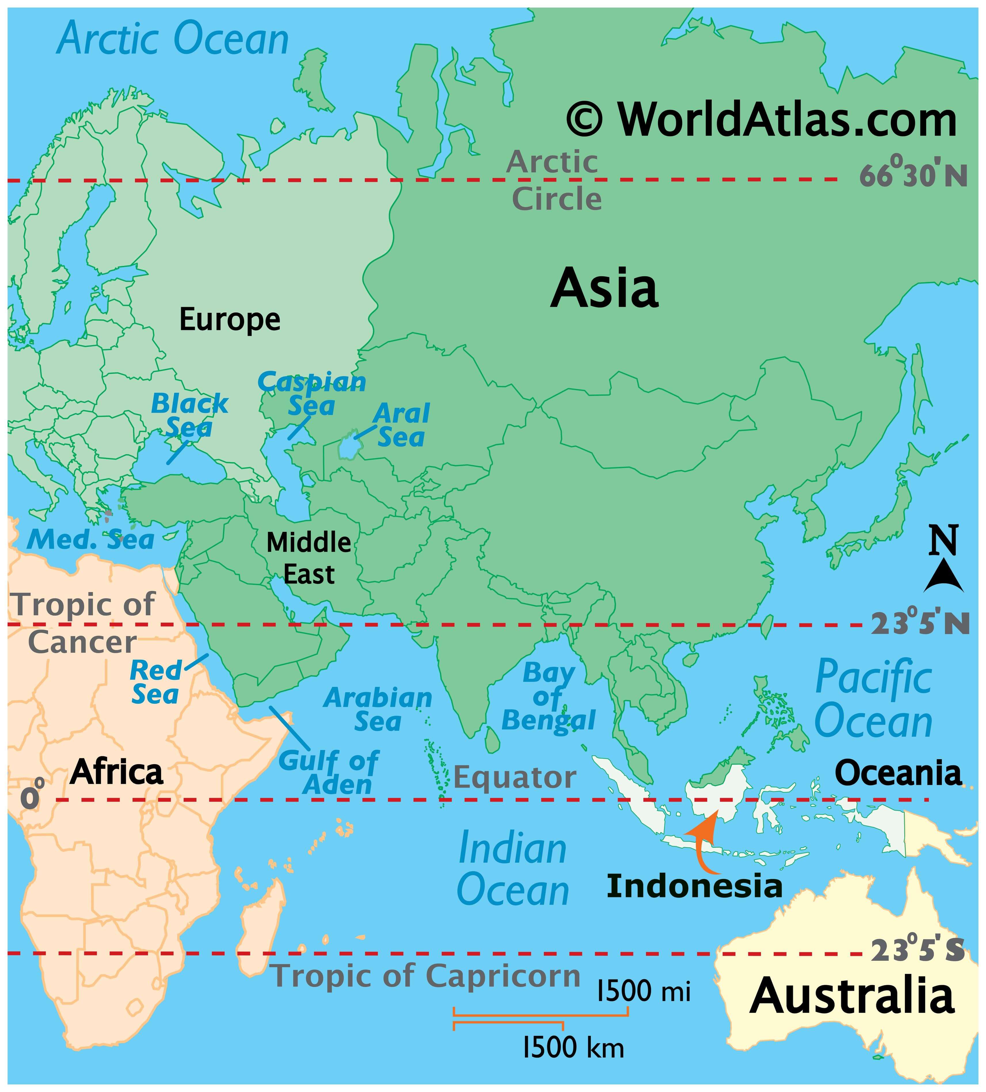
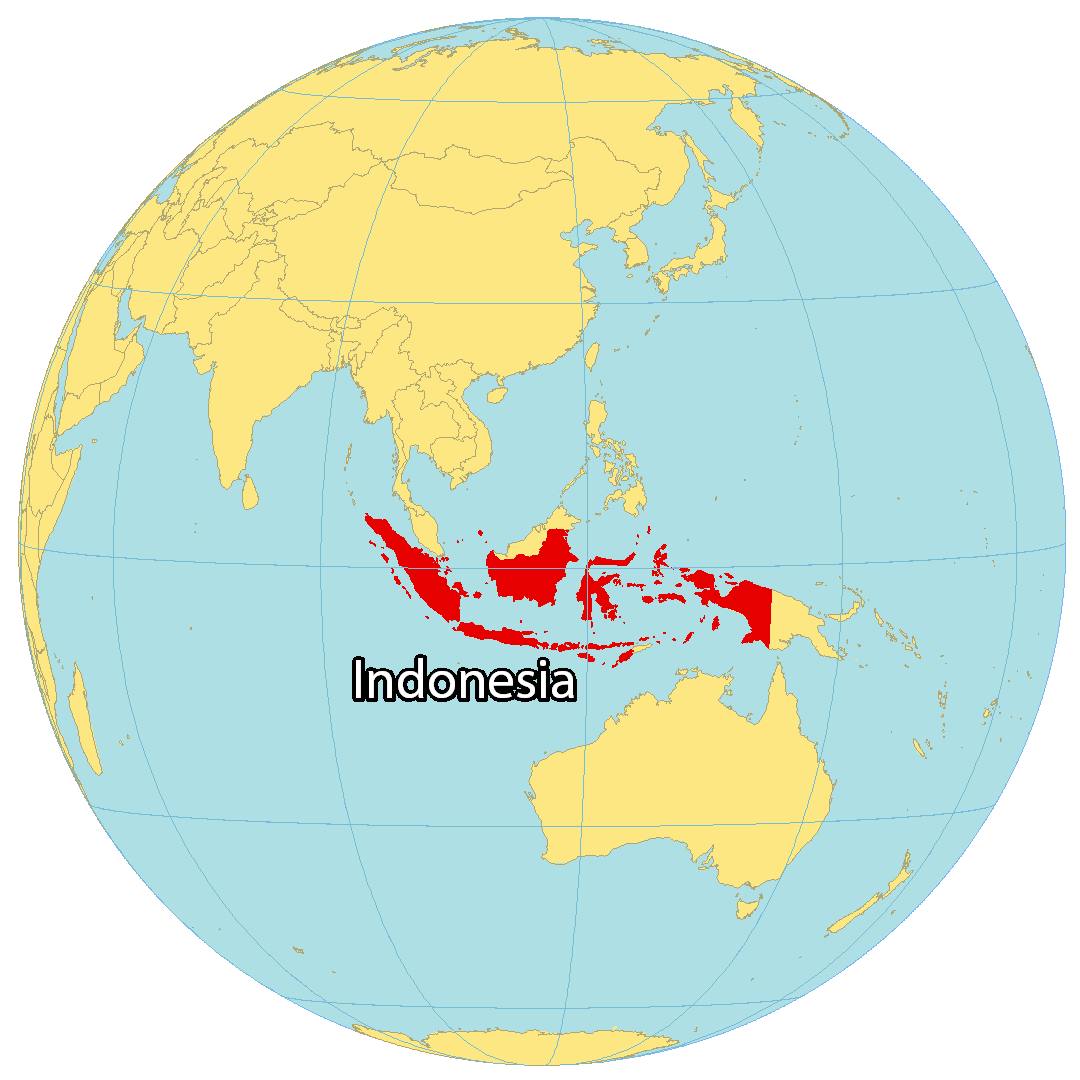
Where is Indonesia?
Indonesia is an archipelago of over 17,500 islands located in southeast Asia, next to the Indian and Pacific Oceans. Five of these islands are considered major, while the remaining 6,000 are uninhabited. It is the fourth most populous country in the world with a population of over 276 million people, and the majority of this population is concentrated on the island of Java, home to the capital city of Jakarta. Other major cities in Indonesia include Surabaya, Bandung, and Bali.
Indonesia is also internationally divided, with Papua New Guinea and East Timor to the east, Brunei, Singapore, and Malaysia to the north, and Australia to the south.

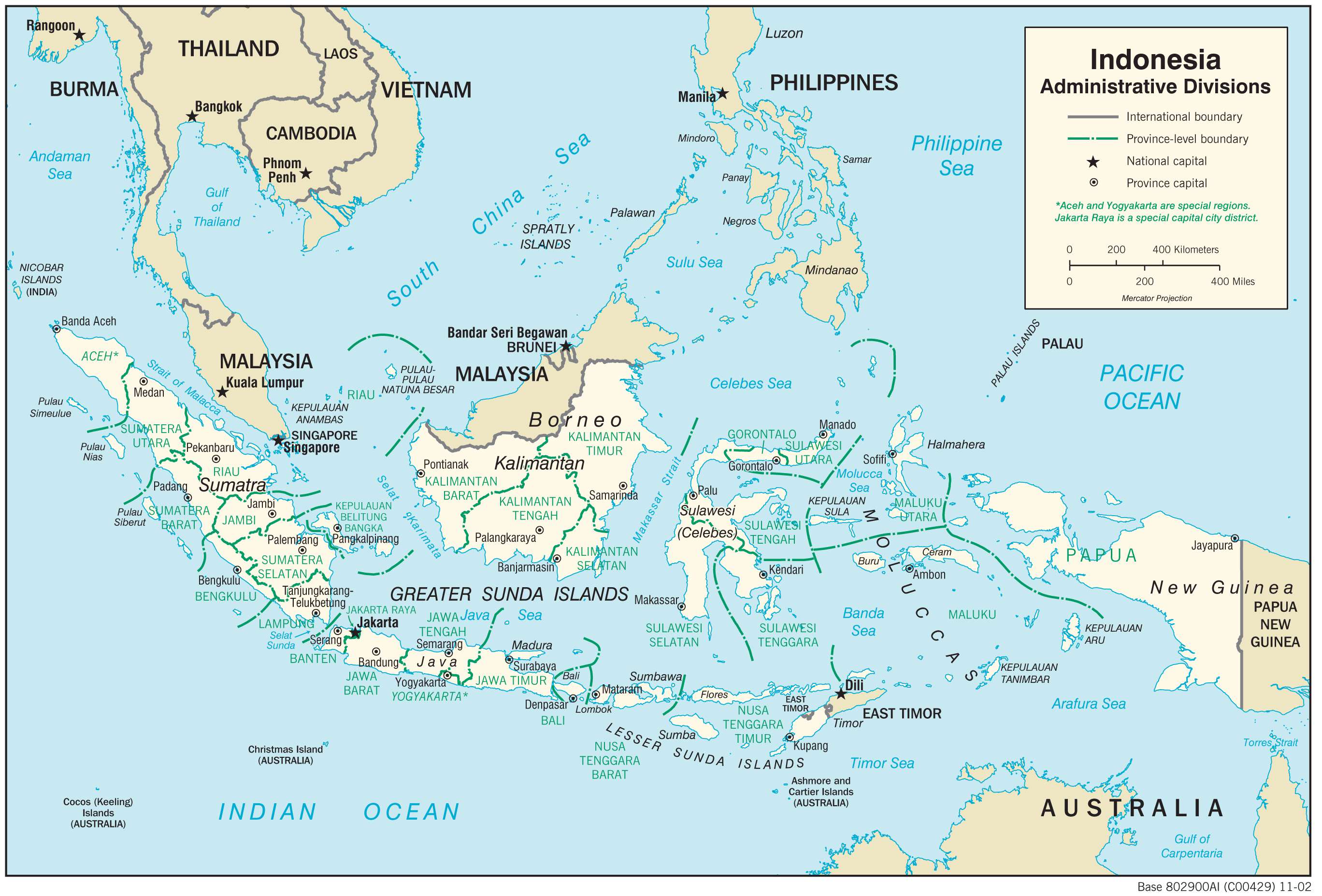
High Definition Political Map of Indonesia

Indonesia Administrative Map
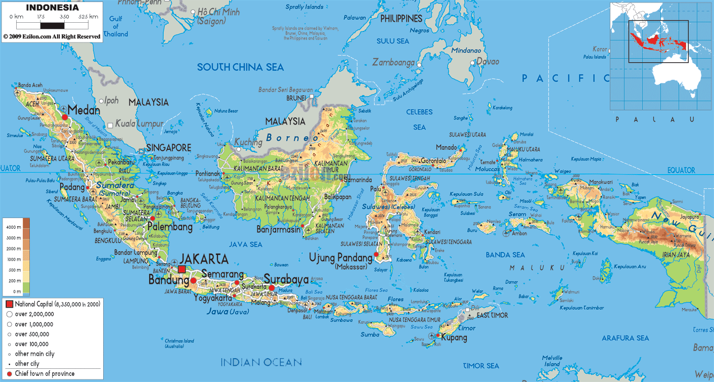
Physical Map of Indonesia
Geography
Indonesia lies between latitudes 11°S and 6°N and longitudes 95°E and 141°E. A transcontinental country spanning Southeast Asia and Oceania, it is the world’s largest archipelagic state, extending 5,120 kilometres (3,181 mi) from east to west and 1,760 kilometres (1,094 mi) from north to south. The country’s Coordinating Ministry for Maritime and Investments Affairs says Indonesia has 17,504 islands (with 16,056 registered at the UN) scattered over both sides of the equator, around 6,000 of which are inhabited. The largest are Sumatra, Java, Borneo (shared with Brunei and Malaysia), Sulawesi, and New Guinea (shared with Papua New Guinea). Indonesia shares land borders with Malaysia on Borneo and Sebatik, Papua New Guinea on the island of New Guinea, East Timor on the island of Timor, and maritime borders with Singapore, Malaysia, Vietnam, the Philippines, Palau, and Australia.
At 4,884 metres (16,024 ft), Puncak Jaya is Indonesia’s highest peak, and Lake Toba in Sumatra is the largest lake, with an area of 1,145 km2 (442 sq mi). Indonesia’s largest rivers are in Kalimantan and New Guinea and include Kapuas, Barito, Mamberamo, Sepik and Mahakam. They serve as communication and transport links between the island’s river settlements.
Climate
Indonesia lies along the equator, and its climate tends to be relatively even year-round. Indonesia has two seasons—a wet season and a dry season—with no extremes of summer or winter. For most of Indonesia, the dry season falls between May and October, with the wet season between November and April. Indonesia’s climate is almost entirely tropical, dominated by the tropical rainforest climate found on every large island of Indonesia. More cooling climate types do exist in mountainous regions that are 1,300 to 1,500 metres (4,300 to 4,900 feet) above sea level. The oceanic climate (Köppen Cfb) prevails in highland areas adjacent to rainforest climates, with reasonably uniform precipitation year-round. In highland areas near the tropical monsoon and tropical savanna climates, the subtropical highland climate (Köppen Cwb) is prevalent with a more pronounced dry season.
Some regions, such as Kalimantan and Sumatra, experience only slight differences in rainfall and temperature between the seasons, whereas others, such as Nusa Tenggara, experience far more pronounced differences with droughts in the dry season and floods in the wet. Rainfall varies across regions, with more in western Sumatra, Java, and the interiors of Kalimantan and Papua, and less in areas closer to Australia, such as Nusa Tenggara, which tends to be dry. The almost uniformly warm waters that constitute 81% of Indonesia’s area ensure that land temperatures remain relatively constant. Humidity is quite high, at between 70 and 90%. Winds are moderate and generally predictable, with monsoons usually blowing in from the south and east in June through October and from the northwest in November through March. Typhoons and large-scale storms pose little hazard to mariners; significant dangers come from swift currents in channels, such as the Lombok and Sape straits.
Several studies consider Indonesia to be at severe risk from the projected effects of climate change. These include unreduced emissions resulting in an average temperature rise of around 1 °C (2 °F) by mid-century, raising the frequency of drought and food shortages (with an impact on precipitation and the patterns of wet and dry seasons, and thus Indonesia’s agriculture system) as well as numerous diseases and wildfires. Rising sea levels would also threaten most of Indonesia’s population, who live in low-lying coastal areas. Impoverished communities would likely be affected the most by climate change.
Geology
Tectonically, most of Indonesia’s area is highly unstable, making it a site of numerous volcanoes and frequent earthquakes. It lies on the Pacific Ring of Fire, where the Indo-Australian Plate and the Pacific Plate are pushed under the Eurasian plate, where they melt at about 100 kilometres (62 miles) deep. A string of volcanoes runs through Sumatra, Java, Bali and Nusa Tenggara, and then to the Banda Islands of Maluku to northeastern Sulawesi. Of the 400 volcanoes, around 130 are active. Between 1972 and 1991, there were 29 volcanic eruptions, mostly on Java. Volcanic ash has made agricultural conditions unpredictable in some areas. However, it has also resulted in fertile soils, a factor in historically sustaining the high population densities of Java and Bali.
A massive supervolcano erupted at present-day Lake Toba around 70,000 BCE. It is believed to have caused a global volcanic winter and cooling of the climate and subsequently led to a genetic bottleneck in human evolution, though this is still in debate. The 1815 eruption of Mount Tambora and the 1883 eruption of Krakatoa were among the largest in recorded history. The former caused 92,000 deaths and created an umbrella of volcanic ash that spread and blanketed parts of the archipelago and made much of the Northern Hemisphere without summer in 1816. The latter produced the loudest sound in recorded history and caused 36,000 deaths due to the eruption itself and the resulting tsunamis, with significant additional effects around the world years after the event. Recent catastrophic disasters due to seismic activity include the 2004 Indian Ocean earthquake and the 2006 Yogyakarta earthquake.
Biodiversity and conservation
Indonesia’s size, tropical climate, and archipelagic geography support one of the world’s highest levels of biodiversity, and it is among the 17 megadiverse countries identified by Conservation International. Its flora and fauna are a mixture of Asian and Australasian species. The Sunda Shelf islands (Sumatra, Java, Borneo, and Bali) were once linked to mainland Asia and have a wealth of Asian fauna. Large species such as the Sumatran tiger, rhinoceros, orangutan, Asian elephant, and leopard were once abundant as far east as Bali, but numbers and distribution have dwindled drastically. Having been long separated from the continental landmasses, Sulawesi, Nusa Tenggara, and Maluku have developed their unique flora and fauna. Papua was part of the Australian landmass and is home to a unique fauna and flora closely related to that of Australia, including over 600 bird species.
Indonesia is second only to Australia in terms of total endemic species, with 36% of its 1,531 species of bird and 39% of its 515 species of mammal being endemic. Tropical seas surround Indonesia’s 80,000 kilometres (50,000 miles) of coastline. The country has a range of sea and coastal ecosystems, including beaches, dunes, estuaries, mangroves, coral reefs, seagrass beds, coastal mudflats, tidal flats, algal beds, and small island ecosystems. Indonesia is one of the Coral Triangle countries with the world’s most enormous diversity of coral reef fish, with more than 1,650 species in eastern Indonesia only.
British naturalist Alfred Russel Wallace described a dividing line (Wallace Line) between the distribution of Indonesia’s Asian and Australasian species. It runs roughly north–south along the edge of the Sunda Shelf, between Kalimantan and Sulawesi, and along the deep Lombok Strait, between Lombok and Bali. Flora and fauna on the west of the line are generally Asian, while east from Lombok is increasingly Australian until the tipping point at the Weber Line. In his 1869 book, The Malay Archipelago, Wallace described numerous species unique to the area. The region of islands between his line and New Guinea is now termed Wallacea.
Indonesia’s large and growing population and rapid industrialisation present serious environmental issues. They are often given a lower priority due to high poverty levels and weak, under-resourced governance. Problems include the destruction of peatlands, large-scale illegal deforestation (causing extensive haze across parts of Southeast Asia), over-exploitation of marine resources, air pollution, garbage management, and reliable water and wastewater services. These issues contribute to Indonesia’s low ranking (number 116 out of 180 countries) in the 2020 Environmental Performance Index. The report also indicates that Indonesia’s performance is generally below average in both regional and global context.
Indonesia has one of the world’s fastest deforestation rates. In 2020, forests covered approximately 49.1% of the country’s land area, down from 87% in 1950. Since the 1970s, log production, various plantations and agriculture have been responsible for much of the deforestation in Indonesia. Most recently, it has been driven by the palm oil industry, which has been criticised for its environmental impact and displacement of local communities. The situation has made Indonesia the world’s largest forest-based emitter of greenhouse gases. It also threatens the survival of indigenous and endemic species. The International Union for Conservation of Nature (IUCN) identified 140 species of mammals as threatened and 15 as critically endangered, including the Bali myna, Sumatran orangutan, and Javan rhinoceros.
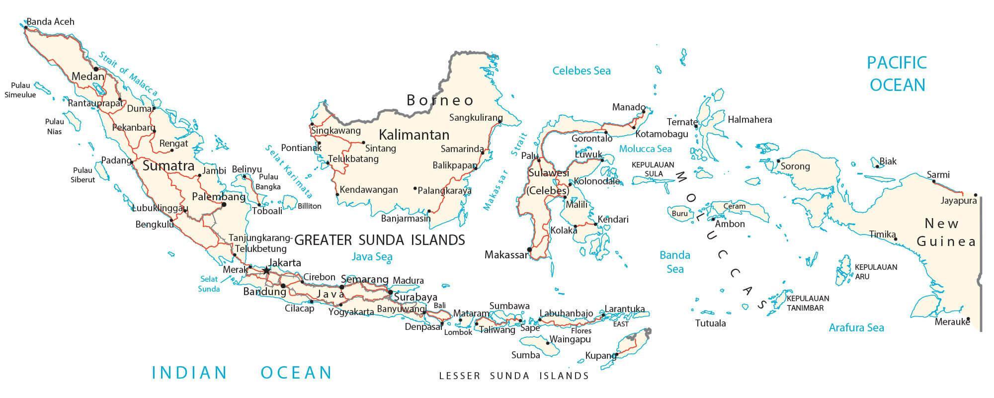
Transportation Map of Indonesia
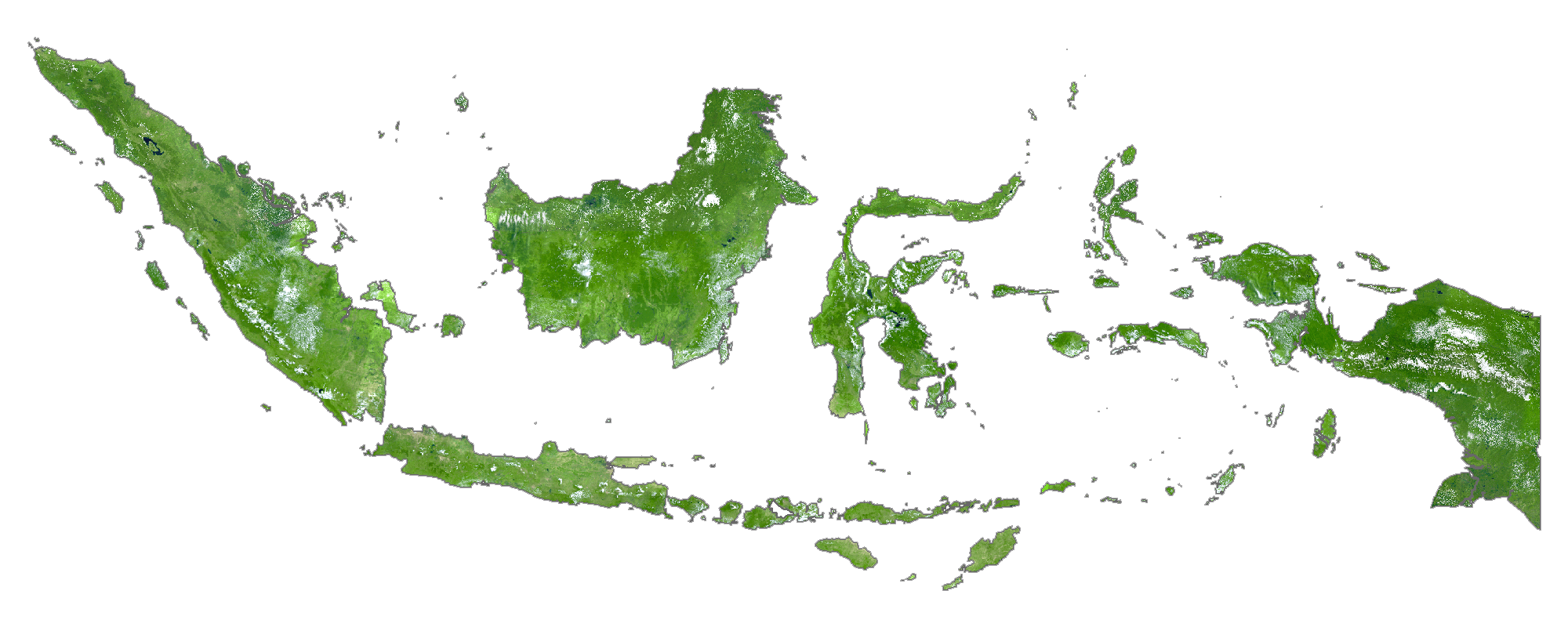
Indonesia Satellite Map