Map of Trinidad & Tobago

Map of Trinidad & Tobago

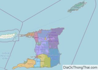
Located just a few miles off the South American continent, Trinidad and Tobago are hilly islands with a few mountains of note. Covering a total area of 5,131 sq.km (1,981 sq mi), the island country of Trinidad and Tobago, consists of two major islands of Trinidad and Tobago, along with many smaller islands. As observed on the … Read more

Map of Senegal

Map of Senegal

Senegal is a relatively flat country in West Africa with an area of 196,712 sq. km. It is located in a depression called the Senegal-Mauritanian Basin. The country can be divided into three major physical regions. To the west is the Cape Verde headland or peninsula with small plateaus of volcanic origin. It hosts the … Read more

Map of Zambia

Map of Zambia

As can be observed on the physical map of Zambia, most of the country consists of a wide plateau, with some scattered mountains (Muchinga) north and central. The major river system, formed by the Zambezi and its tributaries – the Luangwa and Kafue Rivers – cuts into the plateau forming deep valleys and waterfalls such … Read more

Map of Zimbabwe

Map of Zimbabwe

Situated within the tropics of southern Africa, Zimbabwe straddles a high inland plateau that drops northwards to the Zambezi valley. The Inyanga and Udizi Mountains stretch along Zimbabwe’s eastern border with Mozambique, and the country’s highest and lowest point are both found there. Marked on the physical map above, Mount Inyangani at 8,503 ft. (2,592 … Read more

Map of Bosnia & Herz

Map of Bosnia & Herz

Covering an area of 51, 129 sq. km, Bosnia and Herzegovina is located in the western part of the Balkan Peninsula, in the southeastern region of the European continent. As observed on the map, Bosnia and Herzegovina is a very hilly country, with the Dinaric Alps dominating the landscape. Situated near the country’s border with … Read more

Map of Afghanistan

Map of Afghanistan

About the size of the U.S. State of Texas, Afghanistan occupies an area of 647,230 km2 (249,900 sq mi) in Southern Asia.  As observed on the physical map of the country above, most of Afghanistan is a rugged, inhospitable mountainous landscape. More than 50% of the total land area lies above 6,500 ft. (2,000 m). … Read more

Map of Sudan

Map of Sudan

Sudan is a relatively large Northeast African country occupying an area of 1,886,068 sq. km. Massive plains and plateaus cover most of Sudan. The central plain of the country can be divided into three regions depending on topography. The northern part of this plain is a primarily rocky desert area called the Nubian Desert (as … Read more

Map of Botswana

Map of Botswana

Botswana is a Southern African country covering an area of 581,730 sq. km.  The physical map of Botswana illustrates the country’s physical characteristics. The country sits on a flat southern African plateau. The Kalahari Desert blankets the country to the center and southwest while in the north, the Okavango Delta provides a thriving oasis, with … Read more

Map of Laos

Map of Laos

Laos occupies an area of 237,955 sq. km in the Indochinese Peninsula in Southeast Asia. As observed on the physical map of Laos above, the overall topography of Laos is hilly and mountainous with thick green forests. River valleys and an increasingly steep terrain front the mountainous landscape. The Annamite Mountains and Luang Prabang Mountains … Read more

Map of Georgia

Map of Georgia

Located in Eurasia’s Caucasus region, Georgia occupies an area of 69,700 sq. km (26,900 sq mi). As observed on the physical map of Georgia above, it is a very mountainous country, with the rugged Caucasus Mountains stretching across the northern third, and the Lesser Caucasus Mountains dominating the central and southern landscape.The country’s highest point, … Read more

Map of Mali

Map of Mali

Mali is a landlocked country in West Africa with an area of 1,240,192 sq. km.  As observed on the physical map above, Mali has a monotonous landscape with plains and plateaus dominating the country topgraphy. The landscape transitions from Sahara Desert in the north through the Sahel to the zone of Sudanian savanna in the … Read more

Map of Gabon

Map of Gabon

Gabon is easily divided into three distinct regions: a narrow coastal plain, a hilly mountainous interior, and a savanna in the far-east and south. Of note, rainforests cover nearly 85% of the country. The coastal plains form a large section of the World Wildlife Fund’s Atlantic Equatorial coastal forests ecoregion and contain patches of Central … Read more