Map of Slovakia

Map of Slovakia

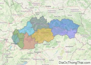
The landlocked sovereign country of Slovakia covers an area of 49,035 km2(18,933 sq mi) in Central Europe. As observed on the physical map of Slovakia, the country has a highly mountainous topography. Heavily-forested, the rugged Ore Mountains and Tatra Mountains dominate the central regions of Slovakia, while the Carpathian Mountains cover its northern borders with the Czech Republic … Read more

Map of Puerto Rico

Map of Puerto Rico

The Commonwealth of Puerto Rico is an unincorporated island territory of the United States of America, located in north-eastern Caribbean Sea. It has a total area of 9,104 sq. km (3,515 sq mi). The territory consists of the main island, and a series of smaller islands, mostly off it’s eastern coastline.  Volcanic in origin, the big rectangular … Read more

Map of Cuba

Map of Cuba

Covering a land area of 109,884 sq. km, Cuba is the largest country by land area in the Caribbean. With an area of 105,006 sq. km, the main island of Cuba is the 16th largest island in the world by land area. Several archipelagos (that include hound reds of island and cay’s) ring it’s coastline … Read more

Map of Ethiopia

Map of Ethiopia

Ethiopia is a landlocked country in East Africa occupying an area of 1,104,300 sq. km.  The country has one of the most rugged and complex topographies in the continent. The five major topographic features of the country are the Rift Valley, Western and Eastern Highlands, and Western and Eastern Lowlands. The North Central massifs of … Read more

Map of Kenya

Map of Kenya

Kenya is a country located in Eastern Africa where it covers an area of 580,367 sq. km.  From its Indian Ocean coastline, Kenya’s flat land rises into central highlands. Those highlands are the site of the country’s highest point; Mount Kenya, standing at 5,199 m. It has been marked on the physical map above. As … Read more

Map of Angola

Map of Angola

The physical map illustrates the four principal regions of Angola:  an arid coastal lowland, hills and mountains that rise inland, a vast plain known as the high plateau (planalto), and rain forest. The mostly flat coastal plain stretches inland for 30 to 100 miles into a belt of rolling hills and a series of scattered mountains. The … Read more

Map of Dominican Republic

Map of Dominican Republic

The Dominican Republic, occupying the eastern two-thirds of the island of Hispaniola, is the 2nd largest country in the Caribbean. It has an area of 48,671 sq. km (18,792 sq mi). As observed on the physical map of the country above, Dominican Republic is mountainous in the central and west, while extensive lowlands dominate the southeast. There … Read more

Map of Sri Lanka

Map of Sri Lanka

Sri Lanka is an island country located to the south of the Indian Peninsula in the Indian Ocean and has an area of 65,610 sq. km. As observed on the physical map above, most of Sri Lanka is low-lying and is ringed by (almost endless) sandy beaches, and small, irregular lagoons. The coastal areas merge into … Read more

Map of Oman

Map of Oman

Oman occupies an area of 309,500 sq. km in the southeastern coast of the Arabian Peninsula.  As observed on the physical map of Oman, the northernmost part of Oman, the Musandam Peninsula, is separated from the rest of the country by a strip of land belonging to the United Arab Emirates. The peninsula is comprised … Read more

Map of Guatemala

Map of Guatemala

A Central American country, Guatemala covers an area of 108,889 sq. km (42,042 sq mi). As observed on the physical map of Guatemala, the country is largely mountainous with rolling hills, plateaus, deep river valleys, and numerous volcanoes. Some of the volcanoes are active.  Major regions include the Central Highlands that separate the Cuchumatanes Mountains of the … Read more

Map of Myanmar (Burma Maps)

Map of Myanmar (Burma Maps)

Myanmar (formerly Burma) occupies an area of 676,578 sq. km in the northwesternmost part of mainland Southeast Asia. The elevation of the country gradually rises from the sea level at the river deltas of the Irrawaddy and Sittang river systems to Mount Kkakabo in the north.  The country can be roughly divided into 5  physiographic … Read more

Map of Luxembourg

Map of Luxembourg

Luxembourg, one of Europe’s smallest nations, has an area of only 2,586 sq. km (998 sq mi).  It is a landlocked country of thick, green forests that cover rolling hills and low mountains.  As can be observed on the physical map of Luxembourg, the country is divided into two regions, Oesling and Gotland.  The northern … Read more