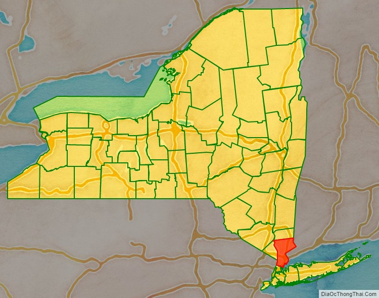
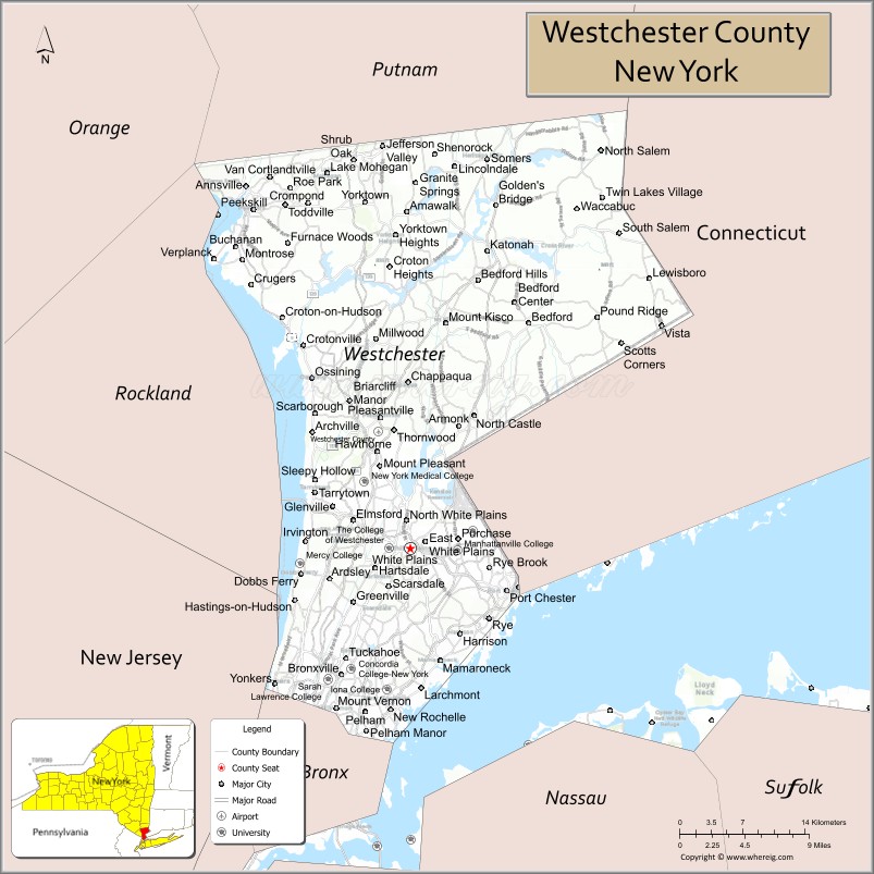
Westchester County is located in the U.S. state of New York. It is the seventh most populous county in the State of New York and the most populous north of New York City. According to the 2020 United States Census, the county had a population of 1,004,456, its highest decennial count ever and an increase of 55,344 (5.8%) from the 949,113 counted in 2010. Located in the Hudson Valley, Westchester covers an area of 450 square miles (1,200 km), consisting of six cities, 19 towns, and 23 villages. Established in 1683, Westchester was named after the city of Chester, England. The county seat is the city of White Plains, while the most populous municipality in the county is the city of Yonkers, with 211,569 residents per the 2020 U.S. Census.
The annual per capita income for Westchester was $67,813 in 2011. The 2011 median household income of $77,006 was the fifth-highest in New York (after Nassau, Putnam, Suffolk, and Rockland counties) and the 47th highest in the United States. By 2021, the county’s median household income had risen to $105,387. Westchester County ranks second in the state after New York County for median income per person, with a higher concentration of incomes in smaller households. Simultaneously, Westchester County had the highest property taxes of any county in the United States in 2013.
Westchester County is one of the centrally located counties within the New York metropolitan area. The county is positioned with New York City, plus Nassau and Suffolk counties (on Long Island, across Long Island Sound), to its south; Putnam County to its north; Fairfield County, Connecticut, to its east; and Rockland County and Bergen County, New Jersey, across the Hudson River to the west. Westchester was the first suburban area of its scale in the world to develop, due mostly to the upper-middle-class development of entire communities in the late 19th century and the subsequent rapid population growth.
Westchester County has numerous road and mass transit connections to New York City, and the county is home to the headquarters of large multinational corporations including IBM, Mastercard, PepsiCo, and Regeneron Pharmaceuticals. Westchester County high school students often feature prominently as winners of the International Science and Engineering Fair and similar STEM-based academic awards.
| Name: | Westchester County |
|---|---|
| FIPS code: | 36-119 |
| State: | New York |
| Founded: | 1683 |
| Seat: | White Plains |
| Largest city: | Yonkers |
| Total Area: | 500 sq mi (1,280 km²) |
| Land Area: | 430 sq mi (1,100 km²) |
| Total Population: | 1,004,457 |
| Population Density: | 2,000/sq mi (800/km²) |
| Time zone: | UTC−5 (North American EST) |
| Summer Time Zone (DST): | UTC−4 (EDT) |
| Website: | westchestergov.com |
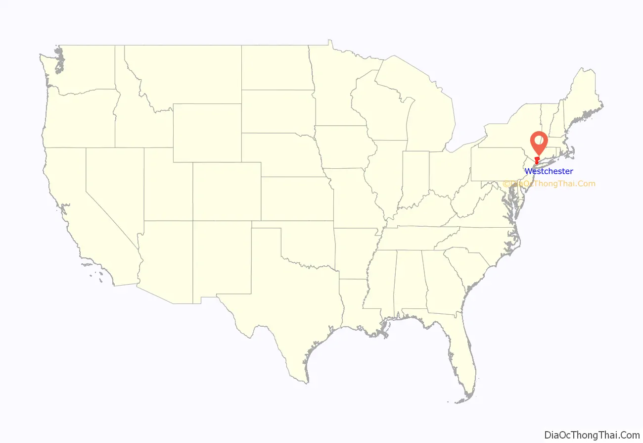
Westchester County location map. Where is Westchester County?
History
At the time of European contact in the 16th and 17th centuries, the Native American inhabitants of present-day Westchester County were part of the Algonquian peoples, whose name for themselves was Lenape, meaning the people. They called the region Lenapehoking, which consisted of the area around and between the Delaware and Hudson Rivers. Several different tribes occupied the area, including The Manhattans, and the Weckquaesgeek and Siwanoy bands of the Wappinger in the south, and Tankiteke, Sintsink and Kitchawank Wappinger in the north.
The first European explorers to visit the Westchester area were Giovanni da Verrazzano in 1524 and Henry Hudson in 1609. Dutch settlers began arriving in the 1620s, followed by settlers from England in the 1640s. Westchester County was one of the original twelve counties of the Province of New York, created by an act of the New York General Assembly in 1683. At the time it included present-day Bronx County, and abutted then-Dutchess County to the north. By 1775, Westchester was the richest and most populous county in the colony of New York. Although the Revolutionary War devastated the county, recovery after the war was rapid. In 1788, five years after the end of the war, the county was divided into 20 towns. In 1798, the first federal census recorded a population of 24,000 for the county.
Two developments in the first half of the 19th century—the construction of the first Croton Dam and Aqueduct, and the coming of the railroad—had enormous impacts on the growth of Westchester. The Croton Dam and Aqueduct was begun in 1837 and completed in 1842; now a National Historic Landmark, the Croton Aqueduct is considered one of the great engineering achievements of the 19th century. In the 1840s, the first railroads were built in Westchester, and included the New York and Harlem Railroad, the Hudson River Railroad, and the New York and New Haven Railroad. The railroads often determined the growth of a town, and the population shifted from Northern to Southern Westchester. By 1860, the total county population was 99,000, with the most populated city being Yonkers.
The period following the American Civil War enabled entrepreneurs in the New York area to create fortunes, and many built large estates, such as Lyndhurst, in Westchester. During the latter half of the 19th century, Westchester’s transportation system and labor force attracted a manufacturing base, particularly along the Hudson River and Nepperhan Creek. In 1874, the western portion of the present Bronx County was transferred to New York County, and in 1895 the remainder of the present Bronx County was also transferred to New York County. These would later split from Manhattan to form a county.
During the 20th century, the rural character of Westchester would transform into the suburban county known today. The Bronx River Parkway, completed in 1925, was the first modern, multi-lane limited-access roadway in North America. The development of Westchester’s parks and parkway systems supported existing communities and encouraged the establishment of new ones, transforming the development pattern for Westchester. With the need for homes expanding after World War II, multistory apartment houses appeared in the urbanized areas of the county, while the market for single-family houses continued to expand. By 1950, the total county population was 625,816. Major interstate highways were constructed in Westchester during the 1950s and 1960s. The establishment of these roadways, along with the construction of the Tappan Zee Bridge, led to further growth in the county.
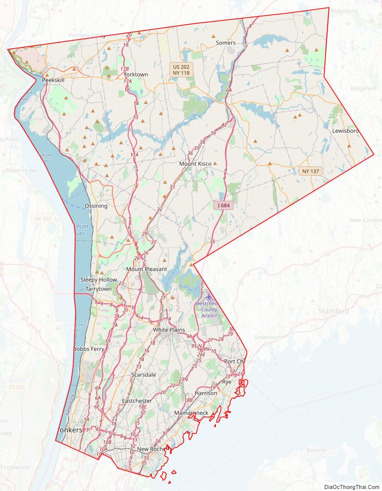
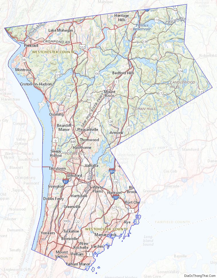
Westchester County Road Map
Geography
Westchester County is located in the New York metropolitan area and Downstate New York, north of New York City and south of Upstate New York. It shares its southern boundary with New York City and its northern border with Putnam County. It is bordered on the west side by the Hudson River and on the east side by the Long Island Sound and Fairfield County, Connecticut. According to the U.S. Census Bureau, the county has a total area of 500 square miles (1,300 km), of which 430 square miles (1,100 km) is land and 69 square miles (180 km) (14%) is water.
Where Pelham Manor meets Pelham Bay Park in the Bronx, the southern border of Westchester is just under 11 miles (18 km) from Columbus Circle in Manhattan. At over 2,700 acres (11 km), Pelham Bay Park is the largest of New York City’s parks, forming a substantial buffer between suburban Westchester and the urban Bronx, while Van Cortlandt Park to the west acts as a similar buffer.
Long Island Sound shore
Westchester’s Long Island Sound shore is generally rocky, interspersed with tidal mud flats, marshes and wetlands, as well as several natural and artificially-maintained sand beaches. Municipal and county owned parks provide access to beaches, nature preserves and passive and active waterfront recreational facilities. Several large harbors lie along the shore including Milton Harbor in Rye, Mamaroneck Harbor, Larchmont Harbor, and Echo Bay, and the upper and lower harbors in southern New Rochelle.
A number of islands can be found off the Long Island Sound shore, most of which are located in New Rochelle. Davids Island, the former location of the U.S. Army’s Fort Slocum, is currently unoccupied but is slated for use as passive parkland; Glen Island, currently a Westchester Parks Department run beach and park, was one of the first amusement parks in the country serving as a summer resort at the turn of the twentieth century; Huckleberry Island is largely undeveloped, and has one of the largest rookeries in western Long Island Sound; Echo Island is owned and used by a private yacht club; Execution Rocks is the site of a 19th-century lighthouse listed on the National Register of Historic Places; Columbia, Pea, and Goose Islands are undeveloped; Clifford, Harrison and Tank Islands are part of the “Five Islands Park” and nature preserve; while Oak and Pine Islands are used as private residences.
Hudson River
The widest section of the Hudson River, at 3.6 miles (6 km), is found between the Westchester and Rockland County shorelines immediately north of Croton Point. In Colonial times, this area was called the Tappan Zee or Sea. The Hudson River is tidal and brackish through Westchester and contains a small number of estuarine marshes. Two bridges span the Hudson in Westchester: the Bear Mountain Bridge crosses at Cortlandt and the Tappan Zee Bridge at Tarrytown. Municipal, county and state-owned parks provide access to waterfront landmarks and sites, including Croton Point in Croton, Kingsland Point in Sleepy Hollow and JFK Memorial Marina in Yonkers.
The Hudson River waterfront in Westchester is in a transitional period, converting from primarily industrial uses to mixed residential, commercial, retail, and recreational uses. This transformation is most notable in Yonkers, Hastings-on-Hudson, Dobbs Ferry, Irvington, Tarrytown, Sleepy Hollow, Ossining, and Peekskill, where redevelopment projects are in various stages of design and completion. In 2004, the county began a project to create Westchester RiverWalk, a walkway along the Hudson River of 51.5 miles (80 km) which will provide pedestrian access between New York City and Putnam County. 32.9 miles of the route are complete and accessible.
At 987 feet (301 m), the highest elevation in the county is a U.S. Coast and Geodetic Survey benchmark known as “Bailey” in Mountain Lakes Park near the Connecticut state line. The lowest elevation is sea level, along both the Hudson and Long Island Sound.
Watersheds
Westchester County is divided into six primary drainage basins or watersheds: the Upper and Lower Long Island Sound; and the Bronx, Upper Hudson, Lower Hudson, and Croton River basins. Within these primary drainage basins are approximately 60 smaller basins, or subwatersheds. The principal streams draining the southern part of the county include Beaver Swamp Brook, Blind Brook, Bronx River, Hutchinson River, Mamaroneck River, Saw Mill River, Sheldrake River, Stephenson Brook and Tibbetts Brook. The primary streams draining the central part of the county include Byram River, Kisco River, Mianus River, Mill River, Pocantico River and Silvermine River. The principal streams draining the northern part of the county include Dickey Brook, Furnace Brook, Hallocks Mill Brook, Hunter Brook, Muscoot River, Peekskill Hollow Brook, and Titicus River. The county contains several major reservoirs; The Croton system and the Kensico Reservoir are important components of the New York City water supply system. The system is a series of interconnected reservoirs and lakes in northern Westchester and Putnam Counties that provide 10% of New York City’s water under normal conditions and up to 30% in times of drought. The components of the system include the New Croton Reservoir, the Cross River Reservoir, the Titicus Reservoir, the Amawalk Reservoir, and the Muscoot Reservoir. Other major reservoirs are the Kensico and Byram Lake Reservoir, while there are a number of smaller reservoirs throughout the county.
The Westchester County Department of Planning divides the county into North, Central and South sub-regions.
Geology
The rock that underlies Manhattan and Westchester is chiefly gneiss and mica-schist, with layers of dolomitic marble and serpentine.
Climate
The climate of Westchester County is primarily a humid subtropical climate (Koppen Cfa), with higher elevations bordering on a humid continental climate. Winters are cold, wet, and occasionally snowy throughout the county, with more snow inland in higher elevations. Summers are hot inland but cooler towards the coast, with somewhat of a relative dryness in the early part of summer. Precipitation is plentiful and in some elevated areas reaches over 50 inches. Snowfall is more common in Westchester than in New York City, with the exception of the southeast of the county where snowfall is often between 20 and 25 inches. In January, inland areas have a low of 21–26 °F and a high of 34–37 °F while coastal areas have a low of 27–30 °F and a high of 38–41 °F. In the summer, this effect is much milder. Coastal areas, including Mamaroneck, New Rochelle, Rye, and Port Chester have highs of 81–83 °F and lows of 68–73 °F, while inland highs will be 84–87 °F and lows will be 65–70 °F. Winds can be heavy, especially by the coast.
Westchester County Topographic Map
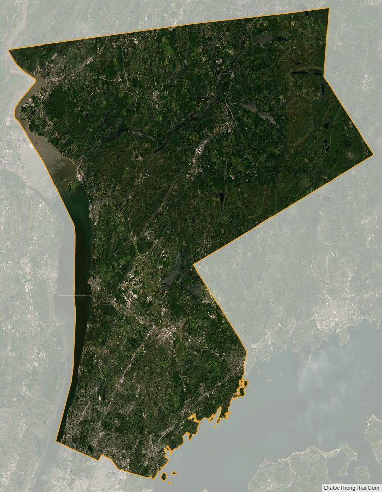
Westchester County Satellite Map
Westchester County Outline Map


