Levittown, a community in the San Juan MSA and part of the municipality of Toa Baja, is one of the largest planned communities in Puerto Rico. Per the 2020 census, the population was 25,591.
It was developed by Levitt & Sons in 1963. Levittown is divided into eight sections called secciones (the eighth section was renamed Urb. Fronteras) and several sub-divisions called urbanizaciones. Part of what is known as Levittown is located in the municipalities of Toa Baja and Bayamon(8th Section now known as Fronteras de Bayamon). Levittown is known for its large, light blue painted water tower (now converted into a public library) that was one of the first water towers in Puerto Rico used to provide potable water to residences. To the west sits Levittown Lakes or Los Lagos de Levittown, a small man-made lake formed by draining the marshland over which Levittown was built. The drainage canal that feeds the lake is called Caño El Hato, which extends into the center of Levittown. To the east, the Bayamon River divides Levittown from the fishing village of Palo Seco, next to the Cataño municipality. To the north, Highway 165 runs along the coastline, but it has not a single official pedestrian crossing for its entire length west of the Rio Hondo, greatly impeding access to the local beaches from the residential areas.
It has a Blue Flag-rated public beach known as Punta Salinas and also one of the bigger public sports centers of the metropolitan area of San Juan with tennis courts and a stadium for track and field meets. Its Olympic-sized pool has been in use since its construction in 1977. Its high school, Dr. Pedro Albizu Campos High School, was built in 1970 and is named after an important political figure on the island. The school’s football team, the Levittown Spartans, have been among the top high school football teams on the island. In 1975 they became the co-champions along with the Pirates from Antilles High School, in Fort Buchanan. Also, the Spartans track teams, coached by Wilfredo Meaux (who would later on coach the team from University of Puerto Rico at Bayamon) were perennial powers during the 1970s and 80s. Levittown High’s Basketball team has produced several excellent players including Ramon Rivas, who played for the NBA with the Boston Celtics. In 2018, the Levittown Baseball Team was the world champions for the first ever Colt World Series Championship, beating the Seoul, Korea team 5 -4. Colt World Series Archives
Levittown’s main avenue is “Bulevar de Levittown”. It has the largest collection of small business in the community. Los Dominicos Avenue is the second main avenue and connects Levittown to other areas, e.g., Sabana Seca sector and the city of Bayamón. Levittown has more than three shopping centers, including Plaza Davison and Rio Hondo Mall. Highway 165 connects Levittown with the towns of Toa Baja, Cataño and Dorado, Puerto Rico. Punta Salinas’ radar domes and El Morro can be seen from this route. At night, the Morro Castle’s lighthouse and the Palo Seco power plant are visible. The coastal area along the road near the Bayamon River is popular with local surfers and is known as Cochino Beach (Pigs Beach), probably because of the brownish waters caused by the sediments flowing out from the river.
Punta Salinas, the public beach, is home to a Puerto Rico Air National Guard unit, the 140 ADS, that provides air traffic control support to the FAA, military and law enforcement operations. It is also the home of a Civil Air Patrol squadron, one of several in the municipality of Toa Baja.
Levittown has tropical weather all year round. The water tower, also known by pilots as the “Levittown Water Tank” provides a visual navigational checkpoint to aircraft flying either to Isla Grande Airport or to Luis Muñoz Marín International Airport. The area around Lago De Plata suffered some flood damages due to the rising water levels during Hurricane Maria.
| Name: | Levittown comunidad |
|---|---|
| LSAD Code: | 55 |
| LSAD Description: | comunidad (suffix) |
| State: | Puerto Rico |
| County: | Toa Baja Municipio |
| Elevation: | 2 m (5 ft) |
| Total Area: | 6.6 km² (2.53 sq mi) |
| Land Area: | 5.9 km² (2.27 sq mi) |
| Water Area: | 0.7 km² (0.26 sq mi) |
| Total Population: | 25,591 |
| Population Density: | 3,900/km² (10,000/sq mi) |
| Area code: | 787 |
| FIPS code: | 7245336 |
| GNISfeature ID: | 2414861 |
Online Interactive Map
Click on ![]() to view map in "full screen" mode.
to view map in "full screen" mode.
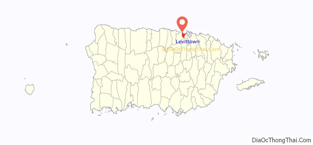
Levittown location map. Where is Levittown comunidad?
Levittown Road Map
Levittown city Satellite Map
See also
Map of other states:- Alabama
- Alaska
- Arizona
- Arkansas
- California
- Colorado
- Connecticut
- Delaware
- District of Columbia
- Florida
- Georgia
- Hawaii
- Idaho
- Illinois
- Indiana
- Iowa
- Kansas
- Kentucky
- Louisiana
- Maine
- Maryland
- Massachusetts
- Michigan
- Minnesota
- Mississippi
- Missouri
- Montana
- Nebraska
- Nevada
- New Hampshire
- New Jersey
- New Mexico
- New York
- North Carolina
- North Dakota
- Ohio
- Oklahoma
- Oregon
- Pennsylvania
- Rhode Island
- South Carolina
- South Dakota
- Tennessee
- Texas
- Utah
- Vermont
- Virginia
- Washington
- West Virginia
- Wisconsin
- Wyoming


