Kaumakani (literally, “place in the wind” in the Hawaiian language) is a census-designated place (CDP) in Kauaʻi County, Hawaiʻi, United States. The population was 749 at the 2010 census, up from 607 at the 2000 census.
| Name: | Kaumakani CDP |
|---|---|
| LSAD Code: | 57 |
| LSAD Description: | CDP (suffix) |
| State: | Hawaii |
| County: | Kauai County |
| Elevation: | 151 ft (46 m) |
| Total Area: | 1.06 sq mi (2.74 km²) |
| Land Area: | 0.95 sq mi (2.46 km²) |
| Water Area: | 0.11 sq mi (0.29 km²) |
| Total Population: | 672 |
| Population Density: | 708.11/sq mi (273.47/km²) |
| ZIP code: | 96747 #& 96769 |
| Area code: | 808 |
| FIPS code: | 1530650 |
| GNISfeature ID: | 0360693 |
Online Interactive Map
Click on ![]() to view map in "full screen" mode.
to view map in "full screen" mode.
Kaumakani location map. Where is Kaumakani CDP?

History
Kaumakani was officially known as “Makaweli” (which means “fearful features” in the Hawaiian language) for over forty years; Makaweli was an ancient land division (ahupuaʻa). In 1914, the Board on Geographic Names ruled that the community was to be named Makaweli, and in 1956 officially renamed the community Kaumakani. Its post office is designated “Kaumakani” and uses the ZIP code 96747. The post office is only open in the mornings.
In 2008, a small settlement to the west at 21°55′59″N 159°38′51″W / 21.93306°N 159.64750°W / 21.93306; -159.64750 (Pakala Village) known as Pākalā Village was designated its own CDP. Pākalā Village has its own post office named “Makaweli” with ZIP code 96769, open only in afternoons. Makaweli Landing at Pākala was called “Robinson’s Landing”, since the family of Aubrey Robinson ran a private ferry to their island of Niʻihau. Pākalā means “the sun shines” in Hawaiian.
Kaumakani Road Map
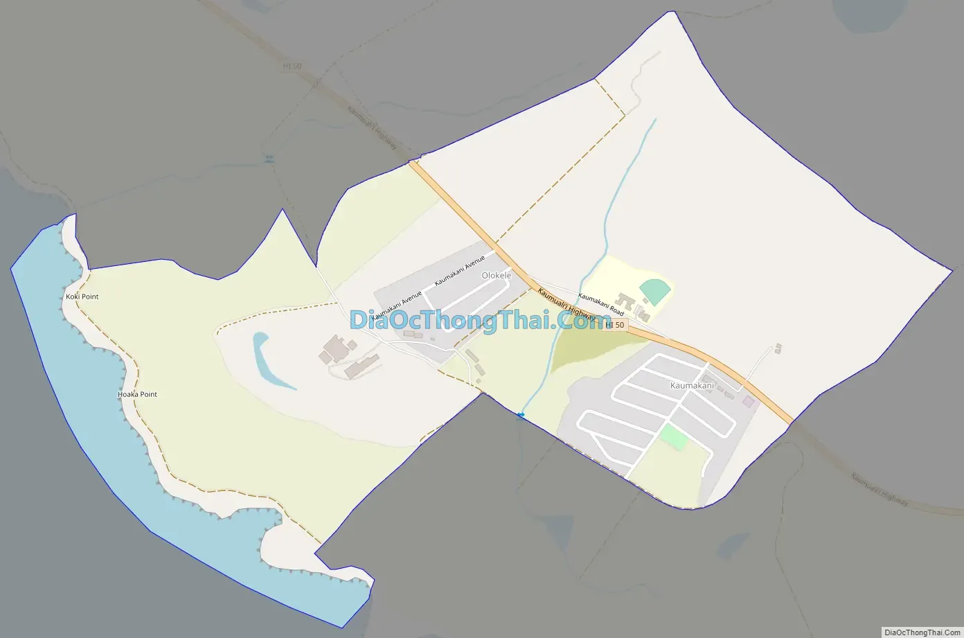
Kaumakani city Satellite Map

Geography
Kaumakani is located on the southern shore of Kauaʻi island at 21°55′13″N 159°37′27″W / 21.92028°N 159.62417°W / 21.92028; -159.62417 (21.920292, -159.624281). The main road is Kaumualiʻi Highway, Route 50.
According to the United States Census Bureau, the Kaumakani CDP has a total area of 1.06 square miles (2.74 km), of which 0.95 square miles (2.46 km) are land and 0.11 square miles (0.29 km), or 10.46%, are water.
Climate
See also
Map of Hawaii State and its subdivision: Map of other states:- Alabama
- Alaska
- Arizona
- Arkansas
- California
- Colorado
- Connecticut
- Delaware
- District of Columbia
- Florida
- Georgia
- Hawaii
- Idaho
- Illinois
- Indiana
- Iowa
- Kansas
- Kentucky
- Louisiana
- Maine
- Maryland
- Massachusetts
- Michigan
- Minnesota
- Mississippi
- Missouri
- Montana
- Nebraska
- Nevada
- New Hampshire
- New Jersey
- New Mexico
- New York
- North Carolina
- North Dakota
- Ohio
- Oklahoma
- Oregon
- Pennsylvania
- Rhode Island
- South Carolina
- South Dakota
- Tennessee
- Texas
- Utah
- Vermont
- Virginia
- Washington
- West Virginia
- Wisconsin
- Wyoming