Kapolei (Hawaiian pronunciation: [kəpoˈlej]) is a planned community in Honolulu County, Hawaiʻi, United States, on the island of Oʻahu. It is colloquially known as the “second city” of Oʻahu, in relation to Honolulu. For statistical purposes, the United States Census Bureau has defined Kapolei as a census-designated place (CDP) within the consolidated city-county of Honolulu.
The community takes its name from a volcanic cone, Puʻu o Kapolei. In the Hawaiian language, puʻu means “hill” and Kapo lei means “beloved Kapo”. According to legend, Kapo, Goddess of Fertility was sister to Pele, Goddess of Fire and Nāmaka, Goddess of the Sea.
Much of the land is part of the estate of industrialist James Campbell. Kapolei’s major developer is Kapolei Property Development, a subsidiary of James Campbell Company. Kapolei sits primarily upon former sugarcane and pineapple fields.
| Name: | Kapolei CDP |
|---|---|
| LSAD Code: | 57 |
| LSAD Description: | CDP (suffix) |
| State: | Hawaii |
| County: | Honolulu County |
| Elevation: | 51 ft (16 m) |
| Total Area: | 4.37 sq mi (11.32 km²) |
| Land Area: | 4.37 sq mi (11.32 km²) |
| Water Area: | 0.00 sq mi (0.00 km²) |
| Total Population: | 21,411 |
| Population Density: | 4,900.66/sq mi (1,892.00/km²) |
| ZIP code: | 96707 |
| Area code: | 808 |
| FIPS code: | 1530300 |
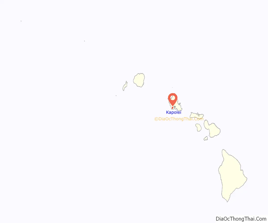
Online Interactive Map
Click on ![]() to view map in "full screen" mode.
to view map in "full screen" mode.
Kapolei location map. Where is Kapolei CDP?
History
In 1955 the Kapolei master plan was drafted and revised 3 different times beginning in 1974. In 1977 the new General Provision Plan adopted the Oʻahu General Plan which dubbed Kapolei “second urban center” (SUC) on the island of Oʻahu. In 1986 the ʻEwa Master Plan was revised to include the SUC and the initial residential construction in the Kapolei area began in the late 1980s with commercial developments springing up shortly thereafter. Nearly two decades later, in 2006 the Kapolei area had more than 800 companies, agencies, and organizations making up approximately 25,000 jobs. As of the 2010 census, the Kapolei CDP had a population of 15,186 people.
The original development objectives for the City of Kapolei were to include: an employment center, a new center for offices and businesses, a center for government offices, a city of people walking, biking, or bussing, the latest energy-efficient technologies such as water conservation and recycling, and the most efficient connectivity for commuting on Oʻahu. In essence a “smart city”. The design plan for development ensures that the 7 themes of Kapolei remain the same throughout its construction. These include 1. Hawaiian Garden City 2. Healthy Living 3. Complete Community Services 4. Pedestrian-friendly 5. Past/Present/Future design architecture 6. Sustainability 7. Technology.
Kapolei is quickly becoming the second urban center of Oʻahu, Hawaiʻi’s most densely populated island. Much of Oʻahu’s future population growth is projected for the Kapolei area, ʻEwa Plain, and southern slopes of the island’s central valley, between Waipahu near Pearl Harbor and Wahiawā near the island’s center.
The U.S. postal code for Kapolei is 96707. In 2002, Pacific Business News reported that 96707 had the second highest median income on the island of Oʻahu, at $62,303. Sperlings’s Best Places reports Kapolei’s median income of $70,129, compared to the national average of $42,350. Nearly one household in five has income exceeding $100,000, with a home ownership rate of 70%.
Kapolei Road Map

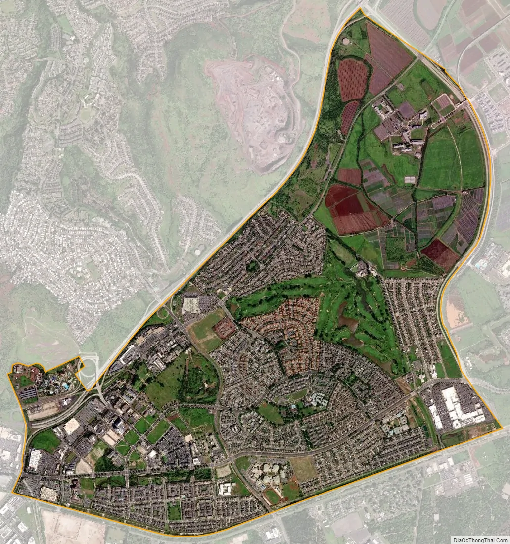
Kapolei city Satellite Map
See also
Map of Hawaii State and its subdivision: Map of other states:- Alabama
- Alaska
- Arizona
- Arkansas
- California
- Colorado
- Connecticut
- Delaware
- District of Columbia
- Florida
- Georgia
- Hawaii
- Idaho
- Illinois
- Indiana
- Iowa
- Kansas
- Kentucky
- Louisiana
- Maine
- Maryland
- Massachusetts
- Michigan
- Minnesota
- Mississippi
- Missouri
- Montana
- Nebraska
- Nevada
- New Hampshire
- New Jersey
- New Mexico
- New York
- North Carolina
- North Dakota
- Ohio
- Oklahoma
- Oregon
- Pennsylvania
- Rhode Island
- South Carolina
- South Dakota
- Tennessee
- Texas
- Utah
- Vermont
- Virginia
- Washington
- West Virginia
- Wisconsin
- Wyoming


