Miami-Dade County (Spanish: Condado de Miami-Dade) is a county located in the southeastern part of the U.S. state of Florida. The county had a population of 2,701,767 as of the 2020 census, making it the most populous county in Florida and the seventh-most populous county in the United States. It is Florida’s third largest county in terms of land area with 1,946 square miles (5,040 km). The county seat is Miami, the core of the nation’s ninth largest and world’s 34th largest metropolitan area with a 2020 population of 6.138 million people, exceeding the population of 31 of the nation’s 50 states as of 2022.
As of 2021, Miami-Dade County has a gross domestic product of $154.9 billion, making it the 14th-largest of the nation’s 3,033 counties. The county is home to the Port of Miami on Biscayne Bay, the world’s largest passenger port with a world record 5.5 million passengers in 2018, and Miami International Airport, the third largest U.S. airport for international passengers and largest U.S. airport for international cargo. The county’s land area of nearly 2,000 square miles exceeds that of two U.S. states, Delaware and Rhode Island. The county is home to several universities and colleges, including the University of Miami in Coral Gables, a private research university that is routinely ranked as one of the nation’s top universities and is the county’s second largest employer with nearly 17,000 employees as of 2021.
Miami-Dade County is heavily Hispanic and was the most populous majority-Hispanic county in the nation as of 2020. It is home to 34 incorporated cities and many unincorporated areas. The northern, central and eastern portions of the county are heavily urbanized with many high-rise buildings along the coastline, including Miami’s Central Business District in Downtown Miami. Southern Miami-Dade County includes the Redland and Homestead areas, which make up the agricultural economy of the county. Agricultural Redland makes up roughly one third of Miami-Dade County’s inhabited land area, and is sparsely populated, a stark contrast to the densely populated, urban portions of the county northern sections.
The county includes portions of two national parks. To the west, the county extends into the Everglades National Park and is populated only by a Miccosukee tribal village. Biscayne National Park and the Biscayne Bay Aquatic Preserves are located east of the mainland in Biscayne Bay.
| Name: | Miami-Dade County |
|---|---|
| FIPS code: | 12-086 |
| State: | Florida |
| Founded: | January 18, 1836 |
| Named for: | Francis L. Dade |
| Total Area: | 2,431.178 sq mi (6,296.72 km²) |
| Land Area: | 1,898.753 sq mi (4,917.75 km²) |
| Total Population: | 2,701,767 |
| Population Density: | 1,422.92/sq mi (549.39/km²) |
| Time zone: | UTC−5 (Eastern Time Zone) |
| Summer Time Zone (DST): | UTC−4 (Eastern Daylight Time) |
| Website: | www.miamidade.gov |
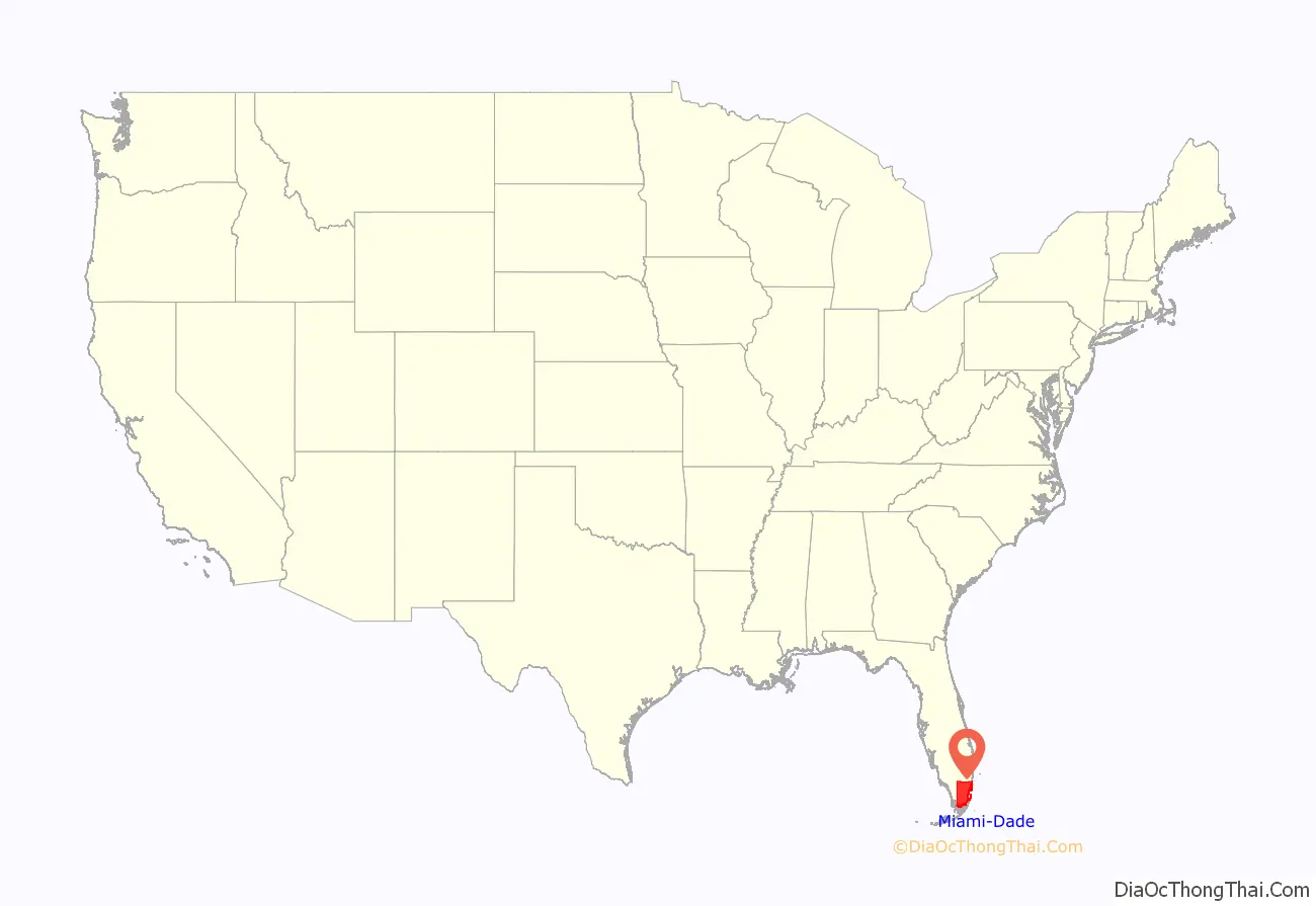
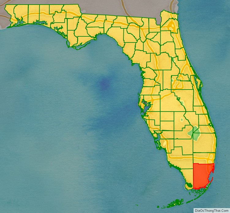
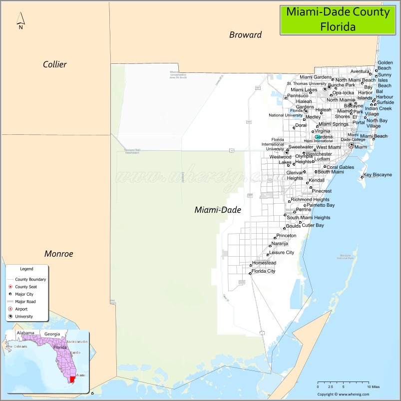
Miami-Dade County location map. Where is Miami-Dade County?
History
Native people
The earliest evidence of Native American settlement in the Miami region came from about 12,000 years ago. The first inhabitants settled on the banks of the Miami River, with the main villages on the northern banks.
The inhabitants at the time of first European contact were the Tequesta people, who controlled much of southeastern Florida, including what is now Miami-Dade County, Broward County, and the southern part of Palm Beach County. The Tequesta Indians fished, hunted, and gathered the fruit and roots of plants for food, but did not practice agriculture. They buried the small bones of the deceased with the rest of the body, and put the larger bones in a box for the village people to see. The Tequesta are credited with making the Miami Circle.
European explorers and settlers
Juan Ponce de León was the first European to visit the area in 1513 by sailing into Biscayne Bay. His journal records he reached Chequescha, a variant of Tequesta, which was Miami’s first recorded name. It is unknown whether he came ashore or made contact with the natives. Pedro Menéndez de Avilés and his men made the first recorded landing when they visited the Tequesta settlement in 1566 while looking for Avilés’ missing son, shipwrecked a year earlier. Spanish soldiers led by Father Francisco Villarreal built a Jesuit mission at the mouth of the Miami River a year later but it was short-lived. After the Spaniards left, the Tequesta Indians were left to fend themselves from European-introduced diseases like smallpox. By 1711, the Tequesta sent a couple of local chiefs to Havana, Cuba, to ask if they could migrate there. The Cubans sent two ships to help them, but Spanish illnesses struck and most of the Tequesta died.
The first permanent European settlers arrived in the early 19th century. People came from the Bahamas to South Florida and the Keys to hunt for treasure from the ships that ran aground on the treacherous Great Florida Reef. Some accepted Spanish land offers along the Miami River. At about the same time, the Seminole Indians arrived, along with a group of runaway slaves. The area was affected by the Second Seminole War, during which Major William S. Harney led several raids against the Indians. Most non-Indian residents were soldiers stationed at Fort Dallas. It was the most devastating Indian war in American history, causing almost a total loss of population in Miami.
After the Second Seminole War ended in 1842, William English re-established a plantation started by his uncle on the Miami River. He charted the “Village of Miami” on the south bank of the Miami River and sold several plots of land. In 1844, Miami became the county seat, and six years later a census reported there were ninety-six residents in the area. The Third Seminole War was not as destructive as the second, but it slowed the settlement of southeast Florida. At the end of the war, a few of the soldiers stayed.
Establishment
Dade County was created on January 18, 1836, under the Territorial Act of the United States. The county was named after Major Francis L. Dade, a soldier killed in 1835 in the Second Seminole War, at what has since been named the Dade Battlefield. At the time of its creation, Dade County included the land that now contains Palm Beach and Broward counties, together with the Florida Keys from Bahia Honda Key north and the land of present-day Miami-Dade County. The county seat was originally at Indian Key in the Florida Keys; then in 1844, the County seat was moved to Miami. The Florida Keys from Key Largo to Bahia Honda were returned to Monroe County in 1866. In 1888 the county seat was moved to Juno, near present-day Juno Beach, Florida, returning to Miami in 1899. In 1909, Palm Beach County was formed from the northern portion of what was Dade County, and then in 1915, Palm Beach County and Dade County contributed nearly equal portions of land to create what is now Broward County. There have been no significant boundary changes to the county since 1915.
Hurricanes
The third-costliest natural disaster to occur in the United States was Hurricane Andrew, which hit Miami in the early morning of Monday, August 24, 1992. It struck the southern part of the county from due east, south of Miami and very near Homestead, Kendall, and Cutler Ridge (now the Town of Cutler Bay). Damages numbered over US$25 billion in the county alone, and recovery has taken years in these areas where the destruction was greatest. This was the costliest natural disaster in US history until Hurricane Katrina struck the Gulf region in 2005.
Name change
On November 13, 1997, voters changed the name of the county from Dade to Miami-Dade to acknowledge the international name recognition of Miami. Voters were acting pursuant to home rule powers granted to Dade County, including the ability to change the name of the county without the consent of the Florida Legislature. The change in name also addressed a source of public dissatisfaction with the name “Dade” which was chosen to honor Francis L. Dade, who had been killed in the Dade battle in the 1830s. The massacre did not occur in South Florida, but in the west central part of the state, in present-day Sumter County, near Bushnell. There is also a Dade City, which is closer to the site of the massacre.
Miami-Dade is the only hyphenated county name in the United States (although Alaska’s Matanuska-Susitna Borough is similarly adorned).
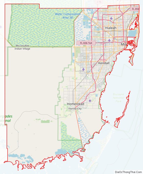
Miami-Dade County Road Map
Geography
According to the U.S. Census Bureau, the county has an area of 2,431 square miles (6,300 km), of which 1,898 square miles (4,920 km) is land and 533 square miles (1,380 km) (21.9%) is water. It is the third-largest county in Florida by land area and second-largest by total area. Most of the water is in the Biscayne Bay, with another significant portion in the adjacent Atlantic Ocean.
Miami-Dade County is only about 6 feet (1.8 m) above sea level. It is rather new geologically and is at the eastern edge of the Florida Platform, a carbonate plateau created millions of years ago. Eastern Dade is composed of Oolite limestone while western Dade is composed mostly of Bryozoa. Miami-Dade is among the last areas of Florida to be created and populated with fauna and flora, mostly in the Pleistocene.
The bay is divided from the Atlantic Ocean by many barrier islands along the coast. The city of Miami Beach, home to the South Beach neighborhood and its Art Deco district, is built on these barrier islands. The archipelago of the Florida Keys, which extends in an arc to the south-southwest, is only accessible through Miami-Dade County, although most of the Keys are part of neighboring Monroe County. Miami is 68 miles from West Palm Beach, and 30 miles from Fort Lauderdale.
Communities
Miami-Dade County includes 34 incorporated areas, 38 census-designated places, and 16 unincorporated regions.
Adjacent counties
- Broward County – north
- Monroe County – southwest
- Collier County – northwest
National protected areas
- Big Cypress National Preserve
- Biscayne National Park
- Everglades National Park
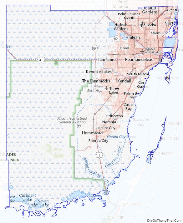
Miami-Dade County Topographic Map
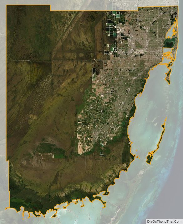
Miami-Dade County Satellite Map
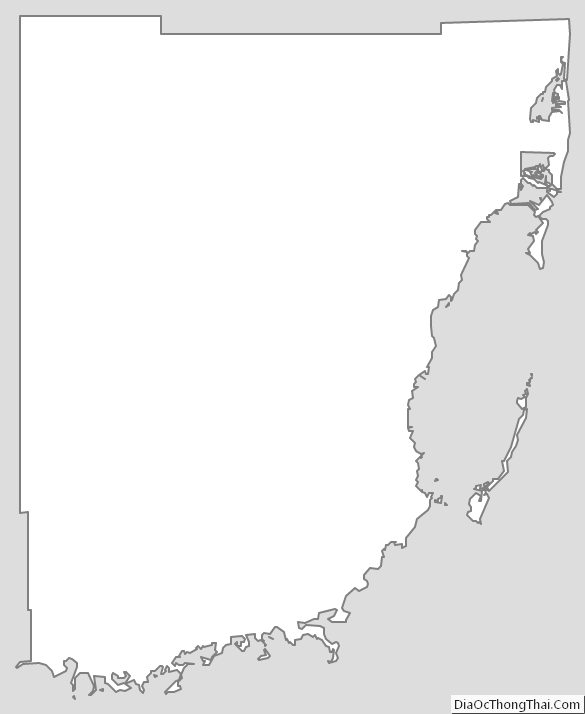
Miami-Dade County Outline Map