Roanoke (/ˈroʊ.əˌnoʊk/ ROH-ə-nohk) is an independent city in the U.S. state of Virginia. At the 2020 census, the population was 100,011, making it the 8th most populous city in the Commonwealth of Virginia and the largest city in Virginia west of Richmond. It is located in the Roanoke Valley of the Roanoke Region of Virginia.
Roanoke is the largest municipality in Southwest Virginia, and is the principal municipality of the Roanoke Metropolitan Statistical Area (MSA), which had a 2020 population of 315,251. It is composed of the independent cities of Roanoke and Salem, and Botetourt, Craig, Franklin, and Roanoke counties. Bisected by the Roanoke River, Roanoke is the commercial and cultural hub of much of Southwest Virginia and portions of Southern West Virginia.
| Name: | Roanoke City |
|---|---|
| FIPS code: | 51-770 |
| State: | Virginia |
| Named for: | Roanoke River |
| Land Area: | 42.52 sq mi (110.13 km²) |
| Population Density: | 2,300/sq mi (900/km²) |
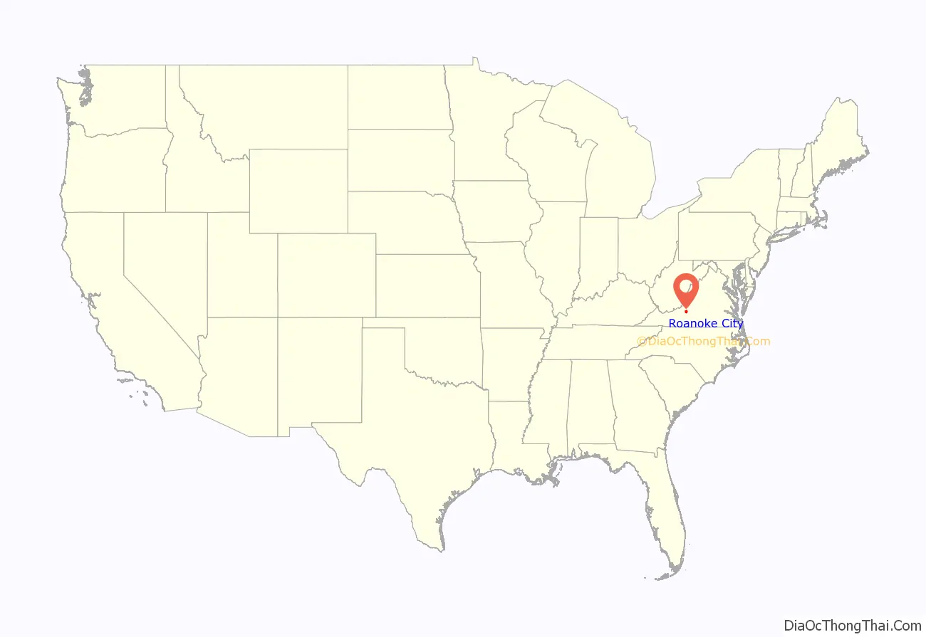
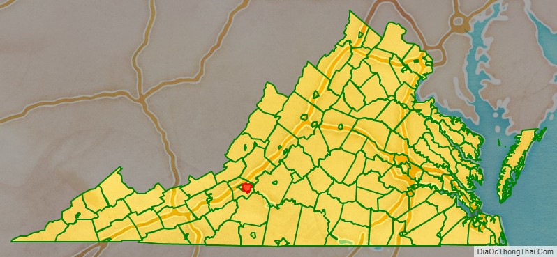
Roanoke City location map. Where is Roanoke City?
History
Timeline
- 1835 – Town of Gainesborough incorporated.
- 1838 – Roanoke County created.
- 1852 – Big Lick Depot built near Gainesborough; Virginia & Tennessee Railroad begins operating.
- 1865 – April: Big Lick settlement sacked by Federal forces during American Civil War.
- 1870 – Atlantic, Mississippi & Ohio Railroad begins operating.
- 1874
- Town of Big Lick incorporated.
- John Trout becomes mayor.
- 1878 – Big Lick News begins publication.
- 1882
- Big Lick and Old Lick renamed “Roanoke”.
- Roanoke Machine Works in business.
- Population: 5,276.
- 1883 – YMCA branch founded.
- 1884 – City of Roanoke incorporated.
- 1885 – Municipal market established.
- 1886 – Roanoke Daily Times newspaper begins publication.
- 1889 – Evening World newspaper begins publication.
- 1890
- Roanoke Hospital founded.
- Population: 16,159.
- 1891 – Roanoke Weekly Press newspaper begins publication.
- 1893 – September 20: “Lynch riot” occurs.
- 1902 – Beth Israel congregation formed.
- 1903 – Agricultural “Great Roanoke Fair” begins.
- 1904 – Chamber of Commerce founded.
- 1906 – Virginian Railway begins operating.
- 1910
- City Health Department established.
- Mill Mountain Incline (funicular) begins operating.
- Population: 34,874.
- 1911 – Roanoke Theatre in business.
- 1913 – Bijou Theatre in business.
- 1914 – YWCA branch founded.
- 1919 – “Juvenile and Domestic Relations Court” established.
- 1920 – Population: 50,842.
- 1921
- Public Library opens.
- Ku Klux Klan branch active (approximate date).
- 1924 – WDBJ radio begins broadcasting.
- 1925 – Patrick Henry Hotel in business.
- 1926 – Memorial Bridge opens.
- 1930 – Big Lick Garden Club formed.
- 1933 – Roanoke Municipal Airport begins operating.
- 1936 – First Dr. Pepper plant east of the Mississippi River opened by John William “Bill” Davis; Roanoke soon becomes the Dr. Pepper Capitol of the World
- 1939 – Roanoke Tribune newspaper begins publication.
- 1950 – Population: 91,921.
- 1952
- WSLS-TV (television) begins broadcasting.
- Mill Mountain Zoo established.
- 1955 – WDBJ-TV (television) begins broadcasting.
- 1957 – Roanoke Historical Society founded.
- 1959 – Temple Emanuel Synagogue built.
- 1966 – Virginia Western Community College established.
- 1976 – Portion of Roanoke County becomes part of city.
- 1980 – Population: 100,220.
- 1985 – Valley View Mall in business.
- 1992 – David A. Bowers becomes mayor.
- 1993 – Bob Goodlatte becomes U.S. representative for Virginia’s 6th congressional district.
- 2000 – City website online (approximate date).
- 2004 – O. Winston Link Museum opens.
- 2010 – Population: 97,032.
- 2016
- October 25: FreightCar America shooting occurs.
- Sherman P. Lea becomes mayor.
- 2020 – The Norfolk Southern locomotive shops cease production in Roanoke after 139 years of operations.
Incorporation
First called Big Lick, after a large outcropping of salt that drew the wildlife to the site near the Roanoke River, the town was established in 1852 and chartered in 1874. In 1882, Big Lick became the town of Roanoke, and in 1884, it was chartered as the independent city of Roanoke. The name Roanoke is said to have originated from an Algonquian word for “shell money”, which was the name used for the river by the Algonquian speakers who lived 300 miles (480 km) away, where the river emptied into the sea near Roanoke Island. The native people who lived near where the city was founded did not speak Algonquian. They spoke Siouan languages, Tutelo, and Catawban. There were also Cherokee speakers in the general area who fought with the Catawba people. The city grew frequently via annexation through the middle of the 20th century. The last annexation was in 1976. The state legislature has since prohibited cities from annexing land from adjacent counties. Roanoke’s location in the Blue Ridge Mountains, in the middle of the Roanoke Valley between Maryland and Tennessee, made it the transportation hub of western Virginia and contributed to its rapid growth.
Colonial influence
During colonial times, the site of Roanoke was an important hub of trails and roads. The Great Indian Warpath, which later merged into the colonial Great Wagon Road, was one of the most heavily traveled roads of 18th-century America. It ran from Philadelphia through the Shenandoah Valley to the future site of Roanoke, where the Roanoke River passed through the Blue Ridge. The Carolina Road branched off in Cloverdale, Virginia, to Boones Mill, Virginia, and on to the Yadkin River Valley. The Roanoke Gap proved a useful route for immigrants to settle the Carolina Piedmont region. At Roanoke Gap, another branch of the Great Wagon Road, the Wilderness Road, continued southwest to Tennessee.
Railroads and coal
In the 1850s, Big Lick became a stop on the Virginia and Tennessee Railroad (V&T) which linked Lynchburg with Bristol on the Virginia-Tennessee border.
After the American Civil War (1861–1865), William Mahone, a civil engineer and hero of the Battle of the Crater, was the driving force in the linkage of three railroads, including the V&T, across the southern tier of Virginia to form the Atlantic, Mississippi & Ohio Railroad (AM&O), a new line extending from Norfolk to Bristol, Virginia in 1870. However, the Financial Panic of 1873 wrecked the AM&O’s finances. After several years of operating under receiverships, Mahone’s role as a railroad builder ended in 1881 when northern financial interests took control. At the foreclosure auction, the AM&O was purchased by E.W. Clark & Co., a private banking firm in Philadelphia which controlled the Shenandoah Valley Railroad then under construction up the valley from Hagerstown, Maryland. The AM&O was renamed Norfolk and Western Railway (N&W).
Frederick J. Kimball, a civil engineer and partner in the Clark firm, headed the new line and the new Shenandoah Valley Railroad. For the junction for the Shenandoah Valley and the Norfolk and Western roads, Kimball and his board of directors selected the small Virginia village called Big Lick, on the Roanoke River. Although the grateful citizens offered to rename their town “Kimball”, at his suggestion, they agreed to name it Roanoke after the river. As the N&W brought people and jobs, the Town of Roanoke quickly became an independent city in 1884. In fact, Roanoke became a city so quickly that it earned the nickname “Magic City”.
Kimball’s interest in geology was instrumental in the development of the Pocahontas coalfields in western Virginia and West Virginia. He pushed N&W lines through the wilds of West Virginia, north to Columbus, Ohio and Cincinnati, Ohio, and south to Durham, North Carolina, and Winston-Salem, North Carolina. This gave the railroad the route structure it was to use for more than 60 years.
The Virginian Railway (VGN), an engineering marvel of its day, was conceived and built by William Nelson Page and Henry Huttleston Rogers. Following the Roanoke River, the VGN was built through the City of Roanoke early in the 20th century. It merged with the N&W in 1959.
The opening of the coalfields made N&W prosperous and Pocahontas bituminous coal world-famous. Transported by the N&W and neighboring Virginian Railway (VGN), local coal fueled half the world’s navies. Today it stokes steel mills and power plants all over the globe.
The Norfolk & Western was famous for manufacturing steam locomotives in-house. It was N&W’s Roanoke Shops that made the company known industry-wide for its excellence in steam power. The Roanoke Shops, with its workforce of thousands, is where the famed classes A, J, and Y6 locomotives were designed, built, and maintained. New steam locomotives were built there until 1953, long after diesel-electric had emerged as the motive power of choice for most North American railroads. About 1960, N&W was the last major railroad in the United States to convert from steam to diesel power. When N&W converted to diesel power, 2,000 railroad workers were laid off.
The presence of the railroad also made Roanoke attractive to manufacturers. American Viscose opened a large rayon plant in Southeast Roanoke in October 1917. This plant closed in 1958, leaving 5,000 workers unemployed.
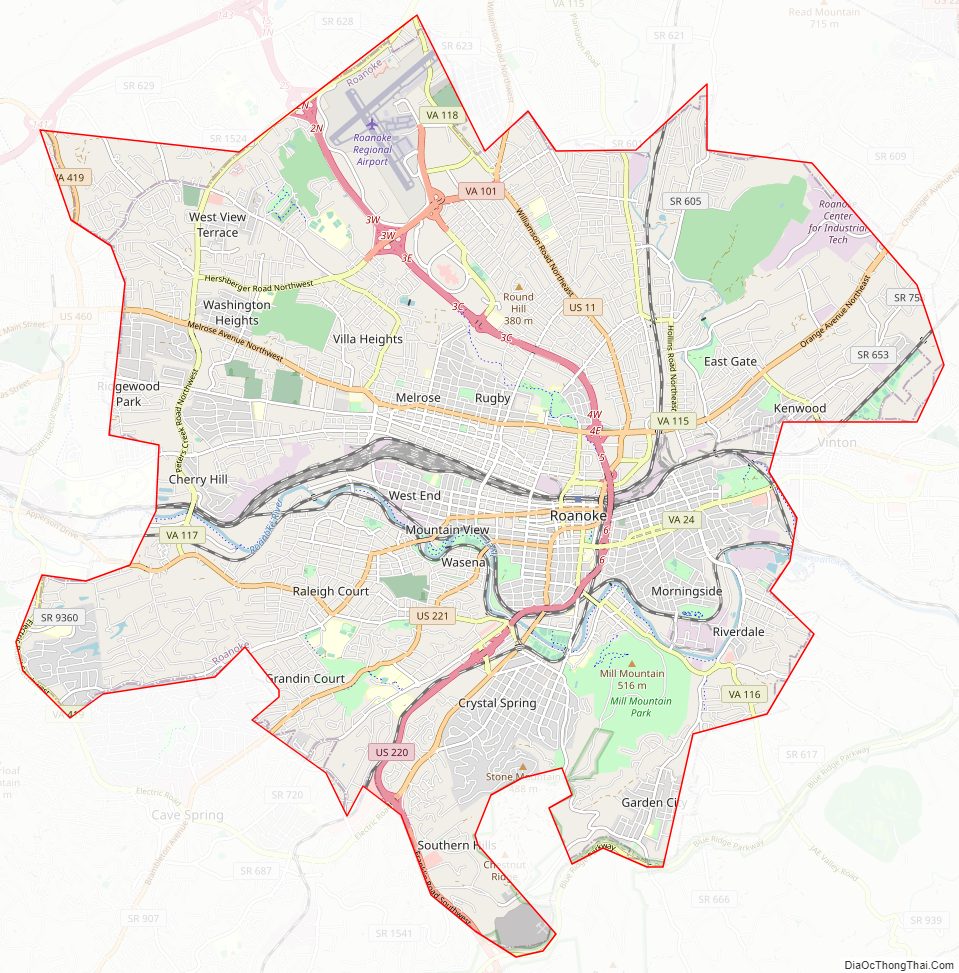
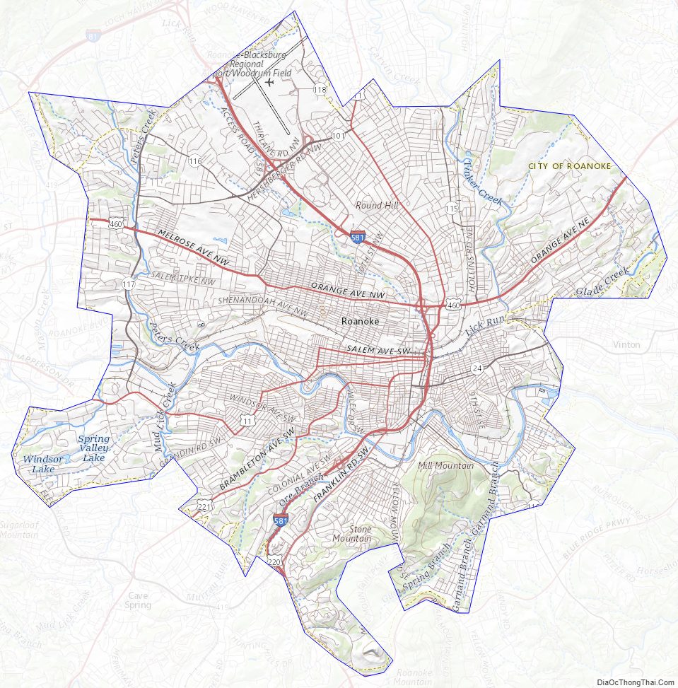
Roanoke City Road Map
Geography
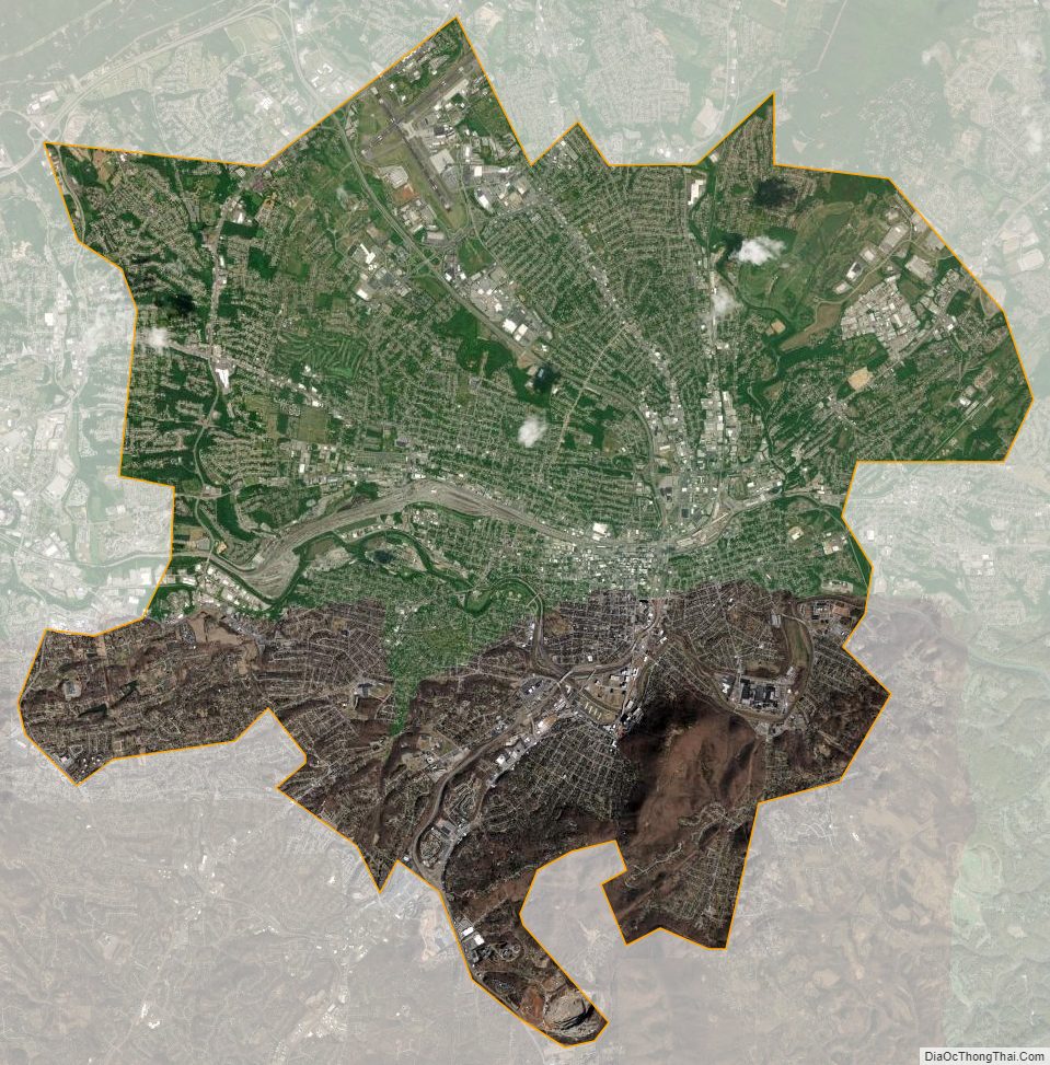
According to the United States Census Bureau, the city has a total area of 42.9 square miles (111.1 km), of which 42.5 square miles (110.1 km) is land and 0.3 square miles (0.8 km) (0.8%) is water.
Roanoke is located in the valley and ridge province of Virginia immediately west of the Blue Ridge Mountains and east of the Allegheny Mountains.
Within the city limits is Mill Mountain, which stands detached from surrounding ranges. Its summit features the Roanoke Star, Mill Mountain Zoo, the Discovery Center interpretive building, and an overlook of the Roanoke Valley. The Appalachian Trail runs through the northern section of Roanoke County several miles north of the city, while the Blue Ridge Parkway runs just to the south of the city. Carvins Cove, the second-largest municipal park in America at 12,700-acre (51 km), lies in northeast Roanoke County and southwest Botetourt County. Smith Mountain Lake is several miles southeast of the city. The Jefferson National Forest is nearby. Roanokers and visitors to the area enjoy hiking, mountain biking, cross-country running, canoeing, kayaking, fly fishing and other outdoor pursuits.
The city is located in the North Fork of Roanoke winemaking region. The “North Fork of Roanoke” appellation is a designated American Viticultural Area, recognizing the unique grape growing conditions present in the area. Valhalla Vineyards is located just outside the city limits of Roanoke.
The Roanoke River flows through the city of Roanoke. Some stretches of the river flow through parks and natural settings, while others flow through industrial areas. Several tributaries join the river in the city, most notably Peters Creek, Tinker Creek and Mud Lick Creek.
Neighborhoods
Within its boundaries, Roanoke is divided into 49 individually defined neighborhoods.
Climate
Though located along the Blue Ridge Mountains at elevations exceeding 900 ft (270 m), Roanoke lies in the humid subtropical climate zone (Köppen Cfa), with four distinct, but generally mild, seasons; it is located in USDA hardiness zone 7b, with the suburbs falling in zone 7a. Extremes in temperature have ranged from 105 °F (41 °C) as recently as August 21, 1983, down to −12 °F (−24 °C) on December 30, 1917, though neither 100 °F (38 °C) nor 0 °F (−18 °C) is reached in most years; the most recent occurrence of each is July 8, 2012 and February 20, 2015. More typically, the area records an average of 6.1 days where the temperature stays at or below freezing and 30.5 days with 90 °F (32 °C)+ highs annually. The normal monthly mean temperature ranges from 37.9 °F (3.3 °C) in January to 77.8 °F (25.4 °C) in July.
Based on the 1991−2020 period, the city averages 14.8 inches (38 cm) of snow per winter. Roanoke experienced something of a snow drought in the 2000s until December 2009 when 17 inches (43 cm) of snow fell on Roanoke in a single storm. Winter snowfall has ranged from trace amounts in 1918–19 and 1919–20 to 62.7 inches (159 cm) in 1959–60; unofficially, the largest single storm dumped approximately three feet (0.9 m) from December 16−18, 1890.
Flooding is the primary weather-related hazard faced by Roanoke. Heavy rains, most frequently from remnants of a hurricane, drain from surrounding areas to the narrow Roanoke Valley. The most recent significant flood was in the fall of 2004, caused by the remains of Hurricane Ivan. The most severe flooding in the city’s history occurred on November 4, 1985, when heavy storms from the remnants of Hurricane Juan stalled over the area. Ten people drowned in the Roanoke Valley and others were saved by rescue personnel.
Many residents complain that they are prone to allergies because of pollen from trees in the surrounding mountains. Most famously, the family of Wayne Newton moved from Roanoke to the dry climate of Phoenix, Arizona, because of his childhood asthma and allergies. However, there have not been clinical studies to establish that these conditions are more prevalent in Roanoke than in other cities with similar vegetation and climate.
Roanoke City Topographic Map
Roanoke City Satellite Map
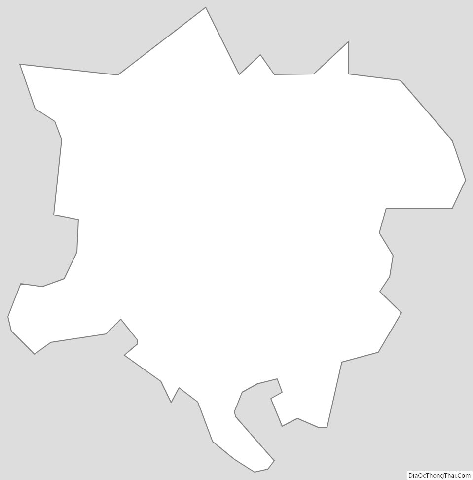
Roanoke City Outline Map