Phoenix (/ˈfiːnɪks/ FEE-niks; Navajo: Hoozdo; O’odham: S-ki:kigk; Spanish: Fénix or Fínix,; Walapai: Banyà:nyuwá) is the capital and most populous city of the U.S. state of Arizona, with 1,608,139 residents as of 2020. It is the fifth-most populous city in the United States, the most populous state capital in the country, and the only U.S. state capital with a population of more than one million residents.
Phoenix is the anchor of the Phoenix metropolitan area, also known as the Valley of the Sun, which in turn is part of the Salt River Valley. The metropolitan area is the 10th-largest by population in the United States, with approximately 4.85 million people as of 2020, making it the largest in the Southwestern United States. Phoenix, the seat of Maricopa County, has the largest area of all cities in Arizona, with an area of 517.9 square miles (1,341 km), and is also the 11th largest city by area in the United States. It is the largest metropolitan area, both by population and size, of the Arizona Sun Corridor megaregion.
Phoenix was settled in 1867 as an agricultural community near the confluence of the Salt and Gila Rivers and was incorporated as a city in 1881. It became the capital of Arizona Territory in 1889. It is in the northeastern reaches of the Sonoran Desert and has a hot desert climate. Despite this, its canal system led to a thriving farming community with the original settlers’ crops remaining important parts of the Phoenix economy for decades, such as alfalfa, cotton, citrus, and hay. Cotton, cattle, citrus, climate, and copper were known locally as the “Five C’s” anchoring Phoenix’s economy. These remained the driving forces of the city until after World War II, when high-tech companies began to move into the valley and air conditioning made Phoenix’s hot summers more bearable.
The city averaged a four percent annual population growth rate over a 40-year period from the mid-1960s to the mid-2000s. This growth rate slowed during the Great Recession of 2007–09, and has rebounded slowly. Phoenix is the cultural center of the state of Arizona.
| Name: | Phoenix city |
|---|---|
| LSAD Code: | 25 |
| LSAD Description: | city (suffix) |
| State: | Arizona |
| County: | Maricopa County |
| Incorporated: | February 25, 1881 |
| Elevation: | 1,086 ft (331 m) |
| Land Area: | 518.27 sq mi (1,342.30 km²) |
| Water Area: | 1.02 sq mi (2.63 km²) |
| Population Density: | 3,102.92/sq mi (1,198.04/km²) |
| FIPS code: | 0455000 |
| GNISfeature ID: | 44784 |
| Website: | www.phoenix.gov |
Explore Phoenix, Arizona with this Map Collection
This Phoenix map collection features highways, roads, places of interest, and things to do. One of the fastest-growing cities in the nation, Phoenix is known for its desert landscapes and year-round sunshine. As the capital of the state of Arizona, the city nicknamed “The Valley of the Sun” is also an important business center and metropolitan area. If you’re looking for a place that is constantly hot and has a lot to offer, look no further than Phoenix, AZ.
This map is your guide to all the places to visit in Phoenix, Arizona. Discover the best of what Phoenix has to offer—from the iconic skyline to the top tourist attractions and hotspots. First, let’s start with an interactive map provided by Google.
Online Interactive Map
Click on ![]() to view map in "full screen" mode.
to view map in "full screen" mode.
Phoenix, Arizona is located in the Salt River Valley and is nicknamed “The Valley of the Sun” because of its extreme heat and desert conditions. This interactive map displays a variety of information and ways to get around Phoenix. From its best local bars, restaurants, and shopping, discover what Phoenix has to offer with this interactive map. Finally, learn about the city in more detail like the metro and surrounding area, such as the 230 miles (370 km) distance to the Grand Canyon.
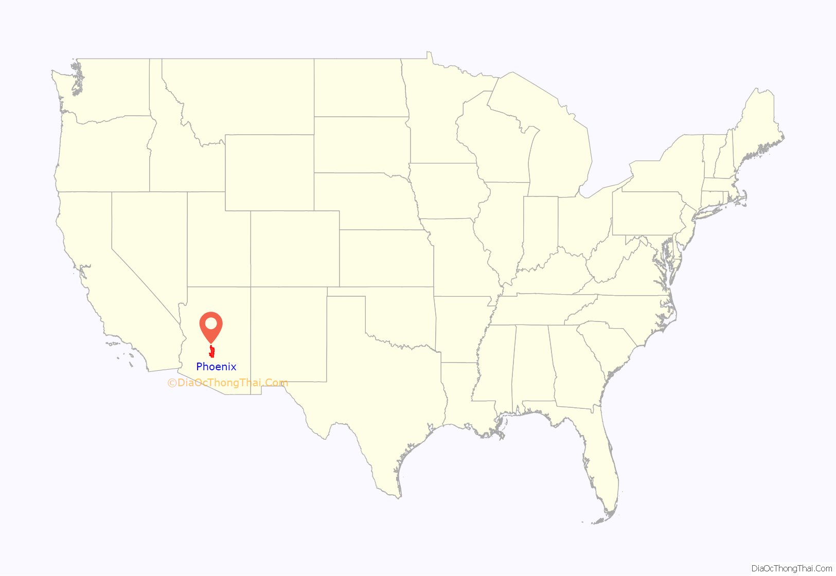
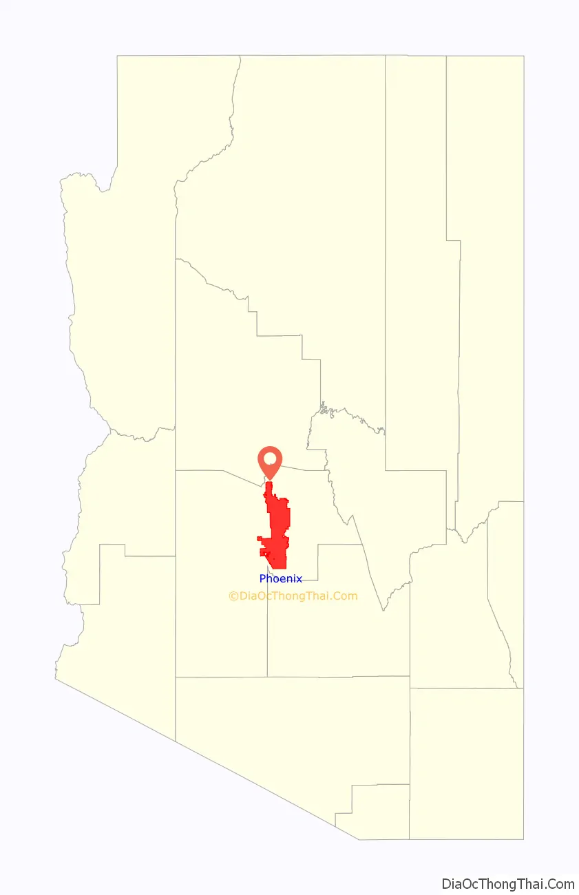
Phoenix location map. Where is Phoenix city?
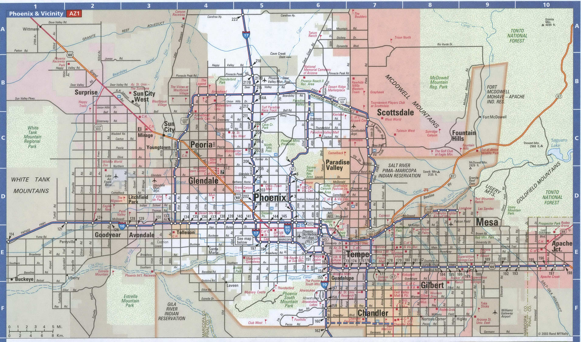
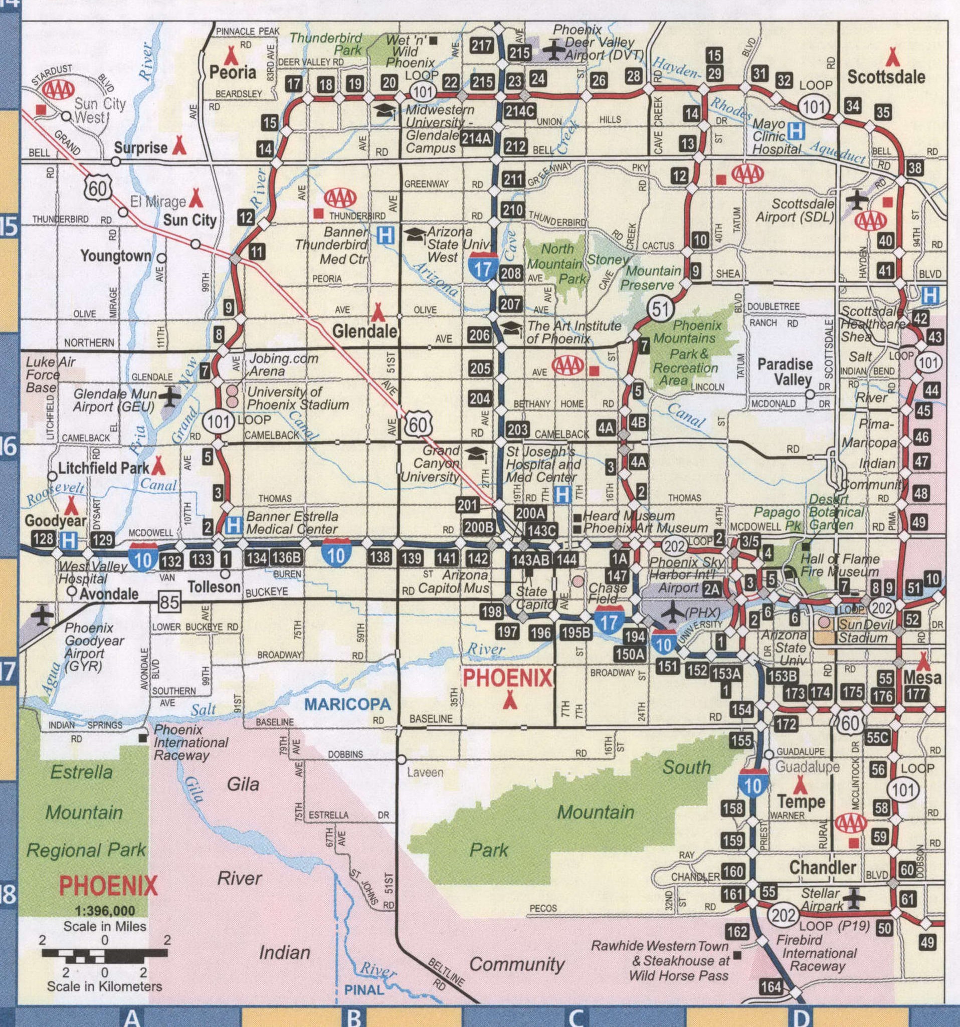
Phoenix Road Map
Whether you want to explore the city, plan a visit, or just want to make sure you see it all, this Phoenix road map will help you get around. This road map of Phoenix is color-coded so you can easily navigate the city and explore Phoenix with ease. It includes road information such as interstates, highways, US highways, expressways/parkways, and major roads. Interstate highways include I-10 and I-17. US highways include 51, 60, 74, 85, 101, 143, 153, 202, Agua Fria Fwy, Black Canyon Hwy, Carefree Hwy, Maricopa Fwy, and Pima Fwy. Expressways/parkways include Black Mountain Pky, Desert Foothills Pky, Greenway Pky, Mountain Pky, Norterra Pky, and North Valley Pky. Major roads include 7th St, 19th Ave, 23rd Ave, 24th St, 40th St, 44th St, 48th St, 51st Ave, 59th Ave, 91st Ave, Baseline Rd, Beardsley Rd, Bell Rd, Buckeye Rd, Cactus Rd, Cave Creek Rd, Chandler Blvd, Dunlap Ave, Dynamite Blvd, Frank Lloyd Wright Blvd, Grand Ave, Indian School Rd, McDonald Dr, McDowell Rd, Olive Ave, Shea Blvd, Sky Harbor Blvd, Tatum Blvd, Thomas Rd, and Union Hills Dr, University Dr. Never get lost again with this Phoenix road map!
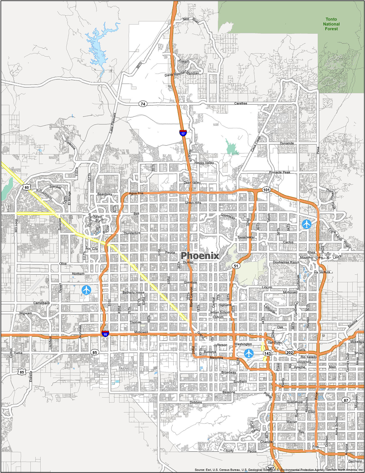
Phoenix is a bustling city with plenty of activities to keep you entertained. From historical landmarks to top-notch hiking and golf courses, there is something for everyone to enjoy. This map of Phoenix is the perfect tool to help you plan your visit, as it highlights major points of interest, such as airports and populated areas. Additionally, you can use it to plan your own personal itinerary and create a route that suits your interests.
Airports: Phoenix Sky Harbor International Airport (PHX)
Cities: Avondale, Chandler, El Mirage, Glendale, Goodyear, Litchfield Park, Mesa, Peoria, Phoenix, Scottsdale, Surprise, Tempe, Tolleson
Towns: Carefree, Cave Creek, Gilbert, Guadalupe, Paradise Valley, Youngtown
Census-designated place (CDP): Anthem, Citrus Park, Gila Crossing, Komatke, Maricopa Colony, New River, St. Johns, Sun City, Sun City West

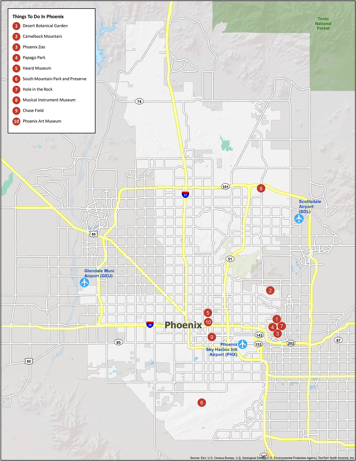
10 things to do in Phoenix city
Phoenix, Arizona is located in the Salt River Valley and is nicknamed “The Valley of the Sun” because of its extreme heat and desert conditions. This interactive map displays a variety of information and ways to get around Phoenix. From its best local bars, restaurants, and shopping, discover what Phoenix has to offer with this interactive map. Finally, learn about the city in more detail like the metro and surrounding area, such as the 230 miles (370 km) distance to the Grand Canyon.
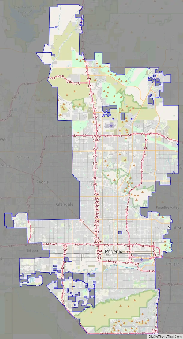
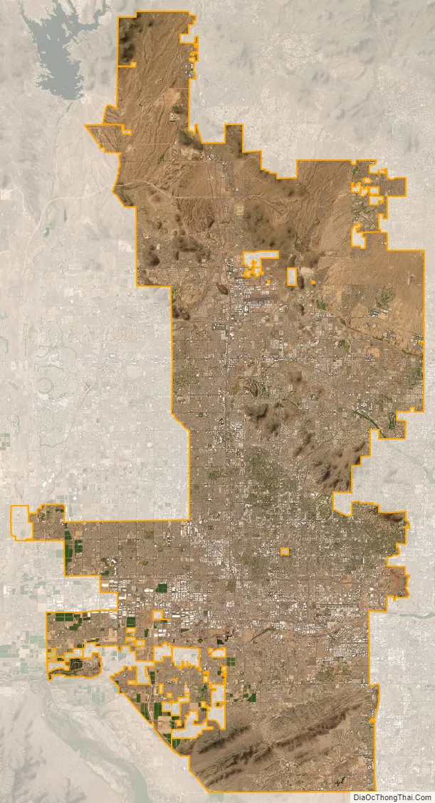
Phoenix city Satellite Map
Geography
Phoenix is in the south-central portion of Arizona; about halfway between Tucson to the southeast and Flagstaff to the north, in the southwestern United States. By car, the city is approximately 150 miles (240 kilometers) north of the US–Mexico border at Sonoyta and 180 mi (290 km) north of the border at Nogales. The metropolitan area is known as the “Valley of the Sun” due to its location in the Salt River Valley. It lies at a mean elevation of 1,086 feet (331 m), in the northern reaches of the Sonoran Desert.
Other than the mountains in and around the city, Phoenix’s topography is generally flat, which allows the city’s main streets to run on a precise grid with wide, open-spaced roadways. Scattered, low mountain ranges surround the valley: McDowell Mountains to the northeast, the White Tank Mountains to the west, the Superstition Mountains far to the east, and both South Mountain and the Sierra Estrella to the south/southwest. Camelback Mountain, North Mountain, Sunnyslope Mountain, and Piestewa Peak are within the heart of the valley. The city’s outskirts have large fields of irrigated cropland and Native American reservation lands. The Salt River runs westward through Phoenix, but the riverbed is often dry or contains little water due to large irrigation diversions. South Mountain separates the community of Ahwatukee from the rest of the city.
According to the United States Census Bureau, the city has an area of 517.9 sq mi (1,341 km), of which 516.7 sq mi (1,338 km) is land and 1.2 sq mi (3.1 km), or 0.2%, is water.
Maricopa County grew by 811% from 186,000 in 1940 to 1,509,000 by 1980, due in part to air conditioning, cheap housing, and an influx of retirees. The once “modest urban sprawl” now “grew by ‘epic’ proportions—not only a myriad of residential tract developments on both farmland and desert.” Retail outlets and office complexes spread out and did not concentrate in the small downtown area. There was low population density and a lack of widespread and significant high-rise development. As a consequence Phoenix became a textbook case of urban sprawl for geographers. Even though it is the fifth most populated city in the United States, the large area gives it a low density rate of approximately 2,797 people per square mile. In comparison, Philadelphia, the sixth most populous city, has a density of over 11,000.
Like most of Arizona, Phoenix does not observe daylight saving time. In 1973, Governor Jack Williams argued to the U.S. Congress that energy use would increase in the evening should Arizona observe DST. He went on to say energy use would also rise early in the day “because there would be more lights on in the early morning.” Additionally, he said daylight saving time would cause children to go to school in the dark.
Cityscape
Since 1979, the city of Phoenix has been divided into urban villages, many of which are based upon historically significant neighborhoods and communities that have since been annexed into Phoenix. Each village has a planning committee appointed directly by the city council. According to the city-issued village planning handbook, the purpose of the village planning committees is to “work with the city’s planning commission to ensure a balance of housing and employment in each village, concentrate development at identified village cores, and to promote the unique character and identity of the villages.” There are 15 urban villages: Ahwatukee Foothills, Alhambra, Camelback East, Central City, Deer Valley, Desert View, Encanto, Estrella, Laveen, Maryvale, North Gateway, North Mountain, Paradise Valley, Rio Vista, and South Mountain.
The urban village of Paradise Valley is distinct from the nearby Town of Paradise Valley. Although the urban village is part of Phoenix, the town is independent.
In addition to the above urban villages, Phoenix has a variety of commonly referred-to regions and districts, such as Downtown, Midtown, Uptown, West Phoenix, North Phoenix, South Phoenix, Biltmore Area, Arcadia, and Sunnyslope.
Flora and fauna
While some of the native flora and fauna of the Sonoran Desert can be found within Phoenix city limits, most are found in the suburbs and the undeveloped desert areas that surround the city. Native mammal species include coyote, javelina, bobcat, mountain lion, desert cottontail rabbit, jackrabbit, antelope ground squirrel, mule deer, ringtail, coati, and multiple species of bats, such as the Mexican free-tailed bat and western pipistrelle, that roost in and around the city. There are many species of native birds, including Costa’s hummingbird, Anna’s hummingbird, Gambel’s quail, Gila woodpecker, mourning dove, white-winged dove, the greater roadrunner, the cactus wren, and many species of raptors, including falcons, hawks, owls, vultures (such as the turkey vulture and black vulture), and eagles, including the golden and the bald eagle.
The greater Phoenix region is home to the only thriving feral population of rosy-faced lovebirds in the U.S. This bird is a popular birdcage pet, native to southwestern Africa. Feral birds were first observed living outdoors in 1987, probably escaped or released pets, and by 2010 the Greater Phoenix population had grown to about 950 birds. These lovebirds prefer older neighborhoods where they nest under untrimmed, dead palm tree fronds.
The area is also home to a plethora of native reptile species including the Western diamondback rattlesnake, Sonoran sidewinder, several other types of rattlesnakes, Sonoran coral snake, dozens of species of non-venomous snakes (including the Sonoran gopher snake and the California kingsnake), the gila monster, desert spiny lizard, several types of whiptail lizards, the chuckwalla, desert horned lizard, western banded gecko, Sonora mud turtle, and the desert tortoise. Native amphibian species include the Couch’s spadefoot toad, Chiricahua leopard frog, and the Sonoran desert toad.
Phoenix and the surrounding areas are also home to a wide variety of native invertebrates including the Arizona bark scorpion, giant desert hairy scorpion, Arizona blond tarantula, Sonoran Desert centipede, tarantula hawk wasp, camel spider, and tailless whip scorpion. Of great concern is the presence of Africanized bees which can be extremely dangerous—even lethal—when provoked.
The Arizona Upland subdivision of the Sonoran Desert (of which Phoenix is a part) has “the most structurally diverse flora in the United States.” One of the most well-known types of succulents, the giant saguaro cactus, is found throughout the city and its neighboring environs. Other native species are the organpipe, barrel, fishhook, senita, prickly pear and cholla cacti; ocotillo; Palo Verde trees and foothill and blue paloverde; California fan palm; agaves; soaptree yucca, Spanish bayonet, desert spoon, and red yucca; ironwood; mesquite; and the creosote bush.
Many non-native plants also thrive in Phoenix including, but not limited to, the date palm, Mexican fan palm, pineapple palm, Afghan pine, Canary Island pine, Mexican fencepost cactus, cardon cactus, acacia, eucalyptus, aloe, bougainvillea, oleander, lantana, bottlebrush, olive, citrus, and red bird of paradise.
See also
Map of Arizona State and its subdivision: Map of other states:- Alabama
- Alaska
- Arizona
- Arkansas
- California
- Colorado
- Connecticut
- Delaware
- District of Columbia
- Florida
- Georgia
- Hawaii
- Idaho
- Illinois
- Indiana
- Iowa
- Kansas
- Kentucky
- Louisiana
- Maine
- Maryland
- Massachusetts
- Michigan
- Minnesota
- Mississippi
- Missouri
- Montana
- Nebraska
- Nevada
- New Hampshire
- New Jersey
- New Mexico
- New York
- North Carolina
- North Dakota
- Ohio
- Oklahoma
- Oregon
- Pennsylvania
- Rhode Island
- South Carolina
- South Dakota
- Tennessee
- Texas
- Utah
- Vermont
- Virginia
- Washington
- West Virginia
- Wisconsin
- Wyoming


