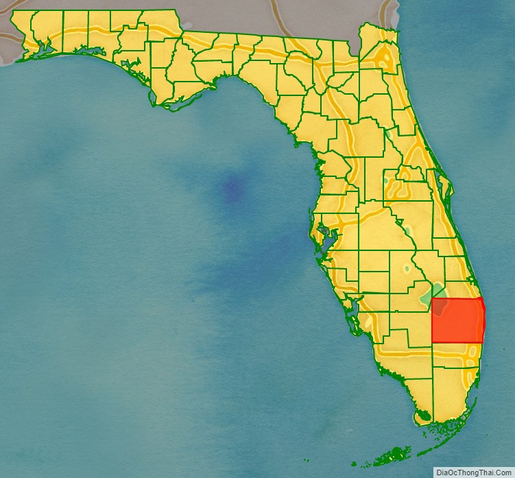
Palm Beach County is a county located in the southeastern part of Florida and lies directly north of Broward County and Miami-Dade County. The county had a population of 1,492,191 as of the 2020 census, making it the third-most populous county in the state of Florida and the 26th-most populous county in the United States. The largest city and county seat is West Palm Beach. Named after one of its oldest settlements, Palm Beach, the county was established in 1909, after being split from Dade County. The county’s modern-day boundaries were established in 1963.
Palm Beach County is one of the three counties that make up the Miami metropolitan area, also referred to as South Florida or the Tri-County area, which was home to an estimated 6,198,782 people in 2018.
The area had been increasing in population since the late 19th century, with the incorporation of West Palm Beach in 1894 and after Henry Flagler extended the Florida East Coast Railway and built the Royal Poinciana Hotel, The Breakers, and Whitehall. In 1928, the Okeechobee hurricane struck Palm Beach County and caused thousands of deaths. More recently, the county acquired national attention during the 2000 presidential election, when a controversial recount occurred.
As of 2004, Palm Beach County is Florida’s wealthiest county, with a per capita personal income of $44,518. It leads the state in agricultural productivity; agriculture is Palm Beach County’s second-largest industry, after real estate development. In undeveloped (central and western) Palm Beach County there is significant tropical agricultural production, especially nurseries, truck crops (vegetables), and sugar cane. Palm Beach County has been called the “Winter Vegetable Capital” of the nation.
| Name: | Palm Beach County |
|---|---|
| FIPS code: | 12-099 |
| State: | Florida |
| Founded: | April 30, 1909 |
| Named for: | Palm Beach |
| Seat: | West Palm Beach |
| Largest city: | West Palm Beach |
| Total Area: | 2,383 sq mi (6,170 km²) |
| Land Area: | 1,970 sq mi (5,100 km²) |
| Total Population: | 1,492,191 |
| Population Density: | 757/sq mi (292/km²) |
| Time zone: | UTC−5 (Eastern) |
| Summer Time Zone (DST): | UTC−4 (EDT) |
| Website: | www.co.palm-beach.fl.us |
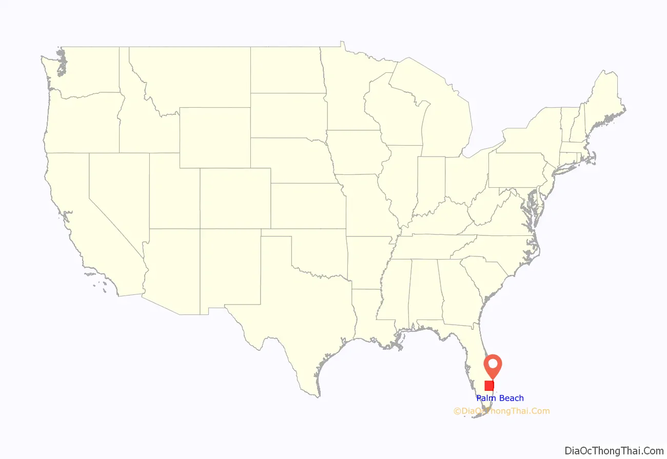
Palm Beach County location map. Where is Palm Beach County?
History
Around 12,000 years ago, Native Americans began migrating into Florida. An estimated 20,000 Native Americans lived in South Florida when the Spanish arrived. Their population diminished significantly by the 18th century, due to warfare, enslavement, and diseases from Europe. In 1513, Juan Ponce de León became the first European in modern-day Palm Beach County when he landed at the Jupiter Inlet. Among the first non-Native American residents were African Americans, many of whom were former slaves or immediate descendants of former slaves, arriving in what was then Spanish Florida in the late 17th century. Finding refuge among the Seminoles, the former slaves or descendants of former slaves fought alongside them against white settlers and bounty hunters during the Seminole Wars. Portions of the Second Seminole War occurred in Palm Beach County, including the Battles of the Loxahatchee in 1838.
The county’s oldest surviving structure, the Jupiter Lighthouse, was built in 1860, after receiving authorization to the land from President Franklin Pierce in 1854. During the American Civil War, Florida was a member of the Confederate States of America. Two Confederate adherents removed the lighting mechanism from the lighthouse. One of the men who removed the light, Augustus O. Lang, was also the first white settler in Palm Beach County. He built a palmetto shack along the eastern shore of Lake Worth in 1863 after abandoning the cause of the Confederacy. After the Civil War ended, the Jupiter Lighthouse was relit in 1866.
In October 1873, a hurricane caused a shipwreck between Biscayne Bay and the New River. The crew survived the wreck but nearly died due to starvation because of the desolation of the area. In response, five Houses of Refuge were built along the east coast of Florida from the Fort Pierce Inlet southward to Biscayne Bay. Orange Grove House of Refuge No. 3 was built near Delray Beach in 1876.
Very few people lived in modern-day Palm Beach County prior to the arrival of Henry Flagler, who first visited in the early 1890s. A Standard Oil tycoon, Flagler was instrumental in the county’s development around the turn of the century. First, he purchased land on both sides of Lake Worth. Other investors followed suit, causing a small boom and bringing in existing businesses and resulting in the establishment of many new businesses. The Royal Poinciana Hotel, constructed by Flagler and his constructed crews to accommodate wealthy tourists, opened for business in February 1894. About a month later, the Florida East Coast Railway, owned by Flagler, reached West Palm Beach. On November 5, 1894, Palm Beach County’s oldest city, West Palm Beach, was incorporated. In 1896, another hotel built by Flagler was opened, the Palm Beach Inn, later renamed The Breakers. He also constructed his own winter home, which he and his wife moved into in 1902. The arrivals of Major Nathan Boynton, Congressman William S. Linton, and railroad surveyor Thomas Rickards in the 1890s also proved important because they developed communities that later became Boynton Beach, Delray Beach, and Boca Raton, respectively.
The Florida Legislature voted to establish Palm Beach County in 1909, carving it out of what was then the northern portion of Dade County and initially including all of Lake Okeechobee. The southernmost part of Palm Beach County was separated to create the northern portion of Broward County in 1915, the northwestern portion became part of Okeechobee County in 1917, and southern Martin County was created from northernmost Palm Beach County in 1925. The boundaries remained the same until 1963, when the Florida Legislature reduced Palm Beach County’s share of Lake Okeechobee from about 80 percent to less than 40 percent and divided the lake more equitably among Glades, Hendry, Martin, and Okeechobee counties. A final change to the county’s boundaries occurred in 2009, when a small portion of land was given to Broward County.
The 1910s and much of the 1920s brought prosperity and rapid population growth to South Florida, coinciding with the Florida land boom of the 1920s. Many local historic districts and landmarks listed in the National Register of Historic Places in Palm Beach County were designed and constructed during the 1920s, with the main contributors being architects Maurice Fatio, Addison Mizner, Marion Sims Wyeth, and the firm Harvey and Clarke, which included Gustav Maass. Total property value in West Palm Beach skyrocketed from $13.6 million in 1920 to $61 million in 1925, before briefly reaching a pre-Great Depression peak of $89 million in 1929. The city’s population quadrupled between 1920 and 1927.
Early on September 17, 1928, the Okeechobee hurricane made landfall near West Palm Beach as a category-4 storm and crossed Lake Okeechobee shortly thereafter. While the hurricane caused catastrophic impact in eastern portions of the county, the Lake Okeechobee region suffered a much heavier loss of life. Wind-driven storm surge in the lake inundated hundreds of square miles, including the nearby communities of Belle Glade, Pahokee, and South Bay. At least 2,500 deaths occurred, many of whom were black migrant farmers. An assessment of impact throughout the county reported 552 businesses destroyed, 1,447 businesses damaged, 3,584 homes destroyed, and 11,409 homes damaged, leaving 4,008 families homeless. However, several cities were excluded, such as Boca Raton, Greenacres, Lantana, and South Palm Beach. Damage in South Florida totaled roughly $25 million. In response to the storm, the Herbert Hoover Dike was constructed to prevent a similar disaster.
As a result of 1926 Miami hurricane and the 1928 storm, Palm Beach County, along with the rest of South Florida, began suffering economic turmoil and pushed the region into the Great Depression, even before the Wall Street Crash of 1929. Housing prices dropped dramatically in the county, with the total real estate value in West Palm Beach falling to $41.6 million in 1930 and then to $18.2 million in 1935. However, the decade also brought an airport to the county. Morrison Field, later renamed the Palm Beach International Airport, opened in 1936.
After the U.S. entered World War II, it was converted to an Air Force Base in 1942. During the war, thousands of servicemen arrived in Palm Beach County for training and supporting the war effort. Following the conclusion of World War II, a number of veterans returned to the area for work, vacation, or retirement. The base was closed and became a commercial airport again in 1962. Migration to the county by workers, tourists, and retirees continued into the 21st century.
On August 28, 1949, a category-4 hurricane struck Lake Worth Beach with maximum sustained winds of 130 mph (215 km/h), causing considerable damage. Throughout Palm Beach County, the hurricane destroyed 65 homes and damaged 13,283 others.
The area’s first television station, WIRK-TV Channel 21, began broadcasting on September 13, 1953. It went off the air less than three years later. However, NBC affiliate WPTV-TV and CBS affiliate WPEC first aired in 1954 and 1955, respectively – both of which are still in existence today.
Richard Paul Pavlick nearly attempted to assassinate then President-elect John F. Kennedy while the family vacationed in Palm Beach in December 1960. On December 11, Pavlick forwent his attempt because Kennedy was with his wife, Jacqueline, and their two children. Four days later, Pavlick’s car, which had sticks of dynamite inside, was surrounded by police and he was arrested. Charges against Pavolick were dropped on December 2, 1963, 10 days after Kennedy was assassinated in Dallas, Texas. Additionally, a secret blast shelter was built on Peanut Island during his presidency because escalating Cold War tensions.
Hurricane David struck near West Palm Beach late on September 3, 1979, with sustained winds of 100 mph (155 km/h). The storm’s winds shattered windows in stores near the coast and caused property damage. A few roofs were torn off, and numerous buildings were flooded from over 6 in (150 mm) of rainfall. Damage in the county reached $30 million, most of which was incurred to agriculture.
The county became the center of controversy during the 2000 presidential election. Allegedly, the “butterfly ballot”, designed by Palm Beach County Supervisor of Elections Theresa LePore, led to an unexpectedly large number of votes for Reform Party candidate Pat Buchanan, rather than for Democrat Al Gore. Due to the aforementioned “butterfly ballot” and the closeness of the statewide results between Gore and Texas Governor George W. Bush, the Florida Supreme Court mandated manual recounts in all counties with disputed results. However, the Supreme Court of the United States overturned the decision in Bush v. Gore on December 12, allowing Florida Secretary of the State Katherine Harris to award the 25 electoral votes to Bush, as Harris’s tally prior to the state-ordered recounts placed him ahead of Gore by 537 popular votes. In turn, this gave Bush victory in the national election.
Following the September 11 attacks in 2001, a Federal Bureau of Investigation investigation revealed that 12 of the 19 hijackers trained or resided in Palm Beach County during the months prior to the attacks. Later that month, during the anthrax attacks, a letter containing spores of this substance was mailed to the American Media, Inc. building in Boca Raton. Three people were exposed to the anthrax, including Robert Stevens, a photo editor who later died after an infection induced by exposure.
Three hurricanes severely impacted Palm Beach County in 2004 and 2005: Frances, Jeanne, and Wilma. On September 5, 2004, Frances made landfall in Martin County as a category-2 hurricane. With wind gusts in Palm Beach County peaking at 91 mph (146 km/h), the storm inflicted structural damage on about 15,000 houses and 2,400 businesses. Six deaths occurred in the county. Jeanne struck near the same location as a category-3 hurricane on September 26, 2004. The storm also brought strong winds, with an official wind gust of 94 mph (151 km/h). About 4,160 homes were damaged and 60 were destroyed. Jeanne left about $260 million in damage in the county. On October 24, 2005, Hurricane Wilma struck Collier County as a category-3 hurricane. The storm moved northeastward, directly crossing Palm Beach County. Several locations reported hurricane-force winds, including a wind gust of 117 mph (188 km/h) in Belle Glade. Over 90% of Florida Power & Light customers lost electricity. Two deaths occurred in Palm Beach County. The storm inflicted some degree of impact to more than 55,000 homes and 3,600 businesses. Palm Beach County suffered about $2.9 billion in damages.
In August 2012, the outer bands of Hurricane Isaac dropped at least 15.86 in (403 mm) of rain near Lion Country Safari. The consequent flooding left neighborhoods in The Acreage, Loxahatchee, Loxahatchee Groves, Royal Palm Beach, and Wellington stranded for up to several days. As Hurricane Irma approached in September 2017, mandatory or voluntary evacuations were ordered for more than 290,000 residents of Palm Beach County. Although the storm passed well west of the county, much of the area experienced hurricane-force wind gusts, with a peak gust of 91 mph (146 km/h) in West Palm Beach. Impact was generally limited to widespread power outages and damaged trees and vegetation, though isolated property damage was reported. The storm left about $300 million in damage in the county, as well as five fatalities.
Toponymy
The coconut palm, Cocos nucifera, is not native to Florida (nor anywhere else in the United States). Its presence in what is today Palm Beach County is due to the shipwreck of the Spanish ship Providencia in 1878, near today’s Mar-a-Lago. It was traveling from Havana to Cádiz, Spain with a cargo of coconuts. The shipwreck was within walking distance of the shore—the Florida State Archives conserves a picture of a painting—and a deliberate grounding so as to obtain an insurance payout has been proposed. The coconuts were salvaged, too many to be eaten, and thousands were planted. A lush grove of palm trees soon grew on what was later named Palm Beach.
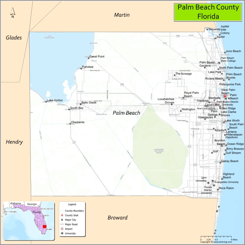
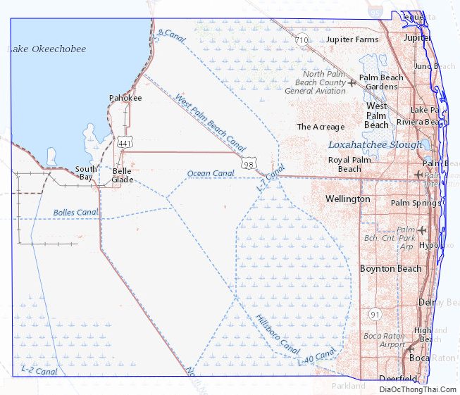
Palm Beach County Road Map
Geography
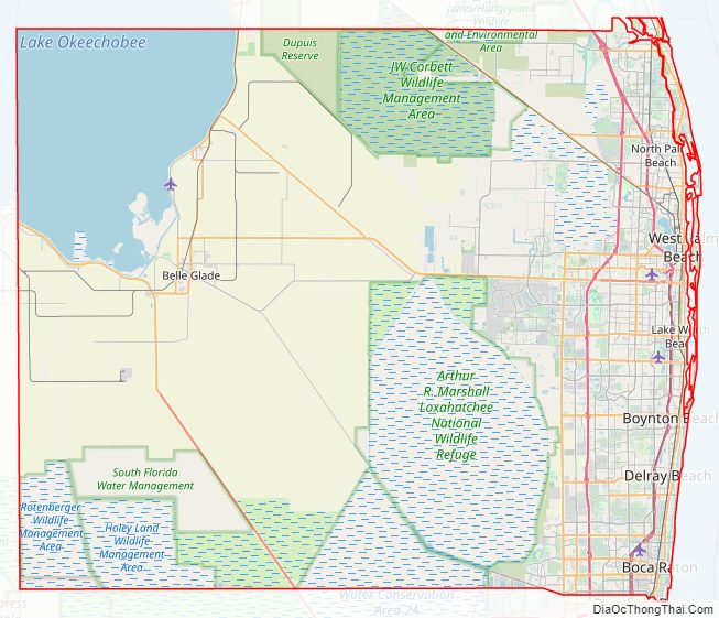
According to the U.S. Census Bureau, the county has a total area of 2,383 square miles (6,170 km), of which 1,970 square miles (5,100 km) are land and 413 square miles (1,070 km) (17.3%) are covered by water. It is the second-largest county in Florida by land area and third-largest by total area. Much of the water is the Atlantic Ocean and Lake Okeechobee. The county has an estimated 526,000 acres (213,000 ha) of farmland.
The eastern third of Palm Beach County is highly urbanized, while the central and western portions of the county are suburban or rural. Palm Beach County is one of three counties in the Miami metropolitan area. However, the county’s western communities along Lake Okeechobee, such as Belle Glade, South Bay, and Pahokee, have also been considered more part of the rural Florida Heartland.
The Atlantic coastline of Palm Beach County is about 47 mi (76 km) in length. It consists mainly of barrier islands and peninsulas, including Jupiter Island, Singer Island, and Palm Beach Island. These islands are separated from the mainland by the Intracoastal Waterway, with much of the waterway locally known as the Lake Worth Lagoon. The main barrier landmasses are split by four inlets: the Jupiter Inlet, the Lake Worth Inlet, the South Lake Worth Inlet, and the Boca Raton Inlet. Two of the four inlets are natural, but significantly altered – the Jupiter and Boca Raton inlets – while the Lake Worth and South Lake Worth inlets are man-made, with the former dug in the 1890s and the latter created between 1926 and 1927. Several other islands exist within the Intracoastal Waterway, including Hypoluxo Island, Munyon Island, and Peanut Island.
Natural areas
- Arthur R. Marshall Loxahatchee National Wildlife Refuge, a 147,392-acre (59,647 ha) refuge in Boynton Beach
- DuPuis Management Area, a 21,875-acre (8,852 ha) area of protected lands
- John D. MacArthur Beach State Park, a 348-acre (141 ha) park in North Palm Beach, Florida
- J.W. Corbett Wildlife Management Area, a 60,348-acre (24,422 ha) area of protected lands
- Jupiter Ridge Natural Area, a 271-acre (110 ha) preserve in Jupiter, Florida
- Juno Dunes Natural Area, a 576-acre (233 ha) preserve in Juno Beach
- Frenchman’s Forest Natural Area, a 158-acre (64 ha) preserve in Palm Beach Gardens
- Sweetbay Natural Area, a 1,094-acre (443 ha) preserve in Palm Beach Gardens
- Royal Palm Beach Pines Natural Area, a 773 acres (313 ha) preserve in Royal Palm Beach.
- Hypoluxo Scrub Natural Area, a 97-acre (39 ha) preserve in Hypoluxo
- Rosemary Scrub Natural Area, a 14-acre (5.7 ha) preserve in Boynton Beach
- Seacrest Scrub Natural Area, a 54-acre (22 ha) preserve in Boynton Beach
- Delray Oaks Natural Area a 25-acre (10 ha) prairie and xeric hammock preserve with a small strand swamp and areas of flatwoods in Delray Beach
- Leon M. Weekes Environmental Preserve, a 12-acre (4.9 ha) preserve in Delray Beach
- Grassy Waters Everglades Preserve, a 14,720-acre (5,960 ha) wetland in West Palm Beach, Florida
In addition, the county has an abundance of coral reef patches along its coastline and has made efforts to preserve them.
Palm Beach County Topographic Map
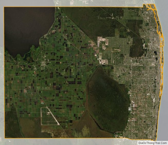
Palm Beach County Satellite Map
Palm Beach County Outline Map