The Municipality and Borough of Skagway is a first-class borough in Alaska on the Alaska Panhandle. As of the 2020 census, the population was 1,240, up from 968 in 2010. The population doubles in the summer tourist season in order to deal with more than 1,000,000 visitors each year. Incorporated as a borough on June 25, 2007, it was previously a city (urban Skagway located at 59°27′30″N 135°18′50″W / 59.45833°N 135.31389°W / 59.45833; -135.31389) in the Skagway-Yakutat-Angoon Census Area (now the Hoonah–Angoon Census Area, Alaska). The most populated community is the census-designated place of Skagway.
The port of Skagway is a popular stop for cruise ships, and the tourist trade is a big part of the business of Skagway. The White Pass and Yukon Route narrow gauge railroad, part of the area’s mining past, is now in operation purely for the tourist trade and runs throughout the summer months. Skagway is also part of the setting for Jack London’s book The Call of the Wild, Will Hobbs’s book Jason’s Gold, and for Joe Haldeman’s novel, Guardian. The John Wayne film North to Alaska (1960) was filmed nearby.
The name Skagway (historically also spelled Skaguay) is derived from sha-ka-ԍéi, a Tlingit idiom which figuratively refers to rough seas in the Taiya Inlet, which are caused by strong north winds. (See, “Etymology and the Mythical Stone Woman”, below.)
| Name: | Skagway Municipality |
|---|---|
| FIPS code: | 02-230 |
| State: | Alaska |
| Founded: | 1897 |
| Land Area: | 9.45 sq mi (24.46 km²) |
| Population Density: | 130/sq mi (50/km²) |
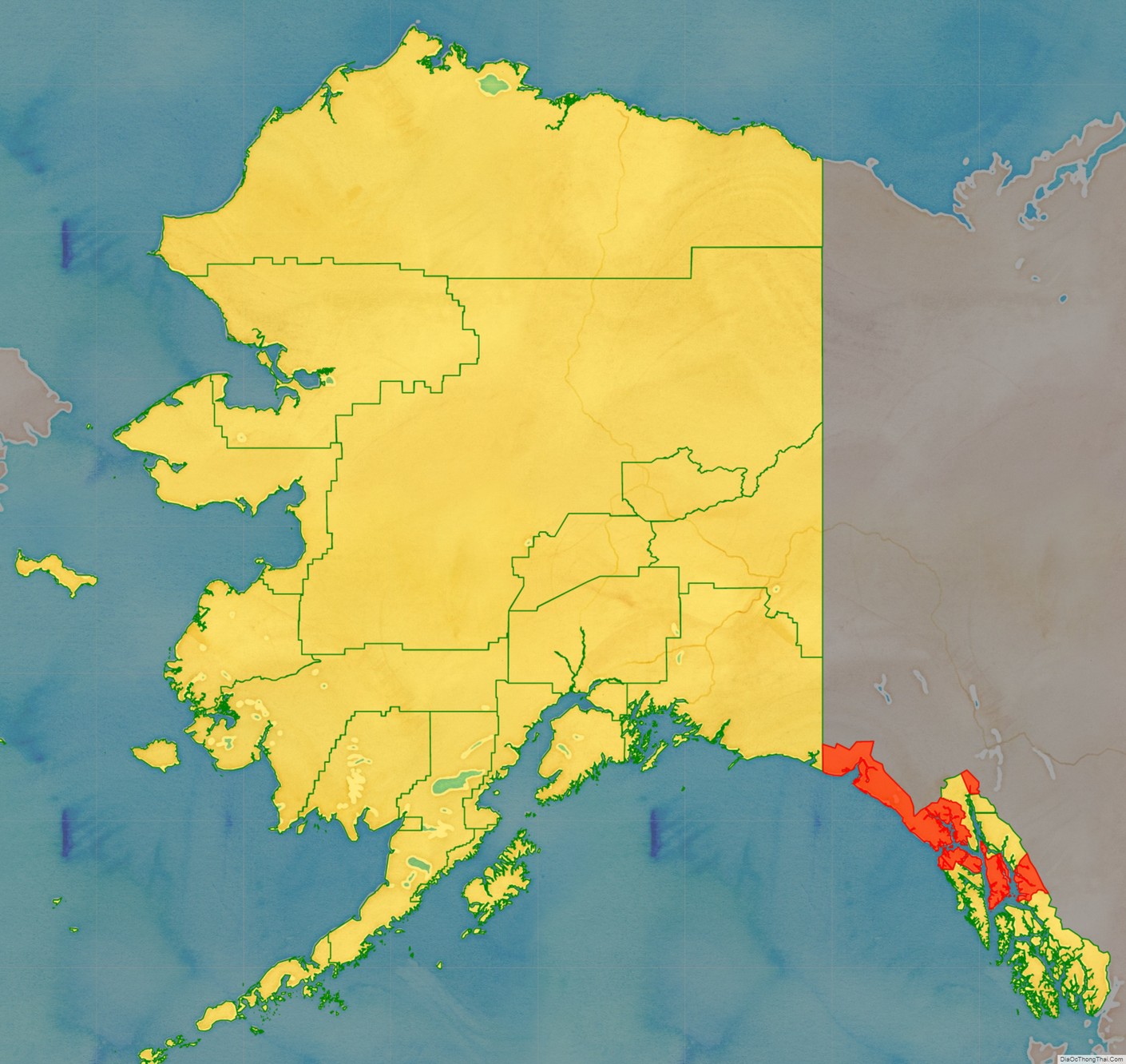
Skagway Municipality location map. Where is Skagway Municipality?
History
Etymology and the Mythical Stone Woman
Skagway was derived from sha-ka-ԍéi, a Tlingit idiom which figuratively refers to rough seas in the Taiya Inlet, that are caused by strong north winds. Literally, sha-ka-ԍéi is a gerund (verbal noun) which means pretty woman. The gerund was derived from the Tlingit finite verb theme -sha-ka-li-ԍéi, which means, in the case of a woman, to be pretty.
The story behind the name is that Sha-ka-ԍéi or Skagway [“Pretty Woman”] was the nickname of Kanagoo, a mythical woman who transformed herself into stone at Skagway bay and who (according to the story) now causes the strong, channeled winds which blow toward Haines, Alaska. The rough seas caused by these winds have therefore been referred to by the use of Kanagoo’s nickname, Sha-ka-ԍéi or Skagway.
The Kanagoo stone formation is now known as Face Mountain, which is seen from Skagway bay. The Tlingit name for Face Mountain is Kanagoo Yahaayí [Kanagoo’s Image/Soul].
Early Skagway
One prominent resident of early Skagway was William “Billy” Moore, a former steamboat captain. As a member of an 1887 boundary survey expedition, he had made the first recorded investigation of the pass over the Coast Mountains, which later became known as White Pass. He believed that gold lay in the Klondike because it had been found in similar mountain ranges in South America, Mexico, California, and British Columbia. In 1887, he and his son, J. Bernard “Ben” Moore, claimed a 160-acre (650,000 m) homestead at the mouth of the Skagway River in Alaska. Moore settled in this area because he believed it provided the most direct route to the potential goldfields. They built a log cabin, a sawmill, and a wharf in anticipation of future gold prospectors passing through.
The boundary between Canada and the United States along the Alaska Panhandle was only vaguely defined then (see Alaska boundary dispute). There were overlapping land claims from the United States’ purchase of Alaska from Russia in 1867 and British claims along the coast. Canada requested a survey after British Columbia united with it in 1871, but the idea was rejected by the United States as being too costly, given the area’s remoteness, sparse settlement, and limited economic or strategic interest.
The Klondike gold rush changed everything. In 1896, gold was found in the Klondike region of Canada‘s Yukon Territory. On July 29, 1897, the steamer Queen docked at Moore’s wharf with the first boat load of prospectors. More ships brought thousands of hopeful miners into the new town and prepared for the 500-mile journey to the gold fields in Canada. Moore was overrun by lot jumping prospectors and had his land stolen from him and sold to others.
The population of the general area increased enormously and reached 30,000, composed largely of American prospectors. Some realized how difficult the trek ahead would be en route to the gold fields, and chose to stay behind to supply goods and services to miners. Within weeks, stores, saloons, and offices lined the muddy streets of Skagway. The population was estimated at 8,000 residents during the spring of 1898 with approximately 1,000 prospective miners passing through town each week. By June 1898, with a population between 8,000 and 10,000, Skagway was the largest city in Alaska.
Due to the sudden influx of visitors to Skagway, some town residents began offering miners transportation services to aid them in their journeys to the Yukon, often at highly inflated rates. A group of miners upset with the treatment organized a town council to help protect their interests. But as the members of the council moved north to try their own hands at mining, control of the town reverted to the more unscrupulous, most notably Jefferson Randolph “Soapy” Smith.
Between 1897 and 1898, Skagway was a lawless town, described by one member of the North-West Mounted Police as “little better than a hell on earth.” Fights, prostitutes and liquor were ever-present on Skagway’s streets, and con man “Soapy” Smith, who had risen to considerable power, did little to stop it. Smith was a sophisticated swindler who liked to think of himself as a kind and generous benefactor to the needy. He was gracious to some, giving money to widows and halting lynchings, while simultaneously operating a ring of thieves who swindled prospectors with cards, dice, and the shell game. His telegraph office charged five dollars to send a message anywhere in the world. Consequently, unknowing prospectors sent news to their families back home without realizing there was no telegraph service to or from Skagway until 1901. Smith also controlled a comprehensive spy network, a private militia called the Skaguay Military Company, the town newspaper, the Deputy U.S. Marshal’s office and an array of thieves and con-men who roamed about the town. Smith was shot and killed by Frank Reid and Jesse Murphy on July 8, 1898, in the famed Shootout on Juneau Wharf. Smith managed to return fire — some accounts claim the two men fired their weapons simultaneously — and Frank Reid died from his wounds twelve days later. Jesse Murphy is believed by some to be responsible for killing Smith, but the official Coroner’s Inquest ruled that it was Reid’s bullet that did the fatal work. ref>Smith, Jeff (2009). Alias Soapy Smith: The Life and Death of a Scoundrel. Juneau, Alaska: Klondike Research. ISBN 978-0-9819743-0-9.</ref>; Inquest Records, 1898-1935, Historic Records of the Office of the Magistrate, City of Skagway, Volume 55, Microfilm 176, Alaska State Archives, Juneau: “Inquest of Jeff R. Smith,” p. 6: “that said Smith [died] by reason of pistol wound piercing the heart. The said wound was the result of a pistol shot fired by one Frank H. Reid.”
Smith and Reid are now interred at the Klondike Gold Rush Cemetery, also known as “Skagway’s Boot Hill.”
The prospectors’ journey began for many when they climbed the mountains over the White Pass above Skagway and onward across the Canada–US border to Bennett Lake, or one of its neighboring lakes, where they built barges and floated down the Yukon River to the gold fields around Dawson City. Others disembarked at nearby Dyea, northwest of Skagway, and crossed northward on the Chilkoot Pass, an existing Tlingit trade route to reach the lakes. The Dyea route fell out of favor when larger ships began to arrive, as its harbor was too shallow for them except at high tide. Officials in Canada began requiring that each prospector entering Canada on the north side of the White Pass bring with him one ton (909 kg) of supplies, to ensure that he did not starve during the winter. This placed a large burden on the prospectors and the pack animals climbing the steep pass.
In 1898, a 14-mile, steam-operated aerial tramway was constructed up the Skagway side of the White Pass, easing the burden of those prospectors who could afford the fee to use it. The Chilkoot Trail tramways also began to operate in the Chilkoot Pass above Dyea. In 1896, before the Klondike gold rush had begun, a group of investors saw an opportunity for a railroad over that route. It was not until May 1898 that the White Pass and Yukon Route began laying narrow gauge railroad tracks in Skagway. The railroad depot was constructed between September and December 1898. This destroyed the viability of Dyea, as Skagway had both the deep-water port and the railroad. Construction of McCabe College, the first school in Alaska to offer a college preparatory high school curriculum, began in 1899. The school was completed in 1900.
By 1899, the stream of gold-seekers had diminished and Skagway’s economy began to collapse. By 1900, when the railroad was completed, the gold rush was nearly over. In 1900, Skagway was incorporated as the first city in the Alaska Territory. Much of the history of Skagway was saved by early residents such as Martin Itjen, who ran a tour bus around the historical town. He was responsible for saving and maintaining the gold- rush cemetery from complete loss. He purchased Soapy Smith’s saloon (Jeff Smith’s Parlor) from going the way of the wrecking ball, and placed many early artifacts of the city’s early history inside and opened Skagway’s first museum.
In July 1923, President Warren G. Harding visited Skagway while on his historic tour through Alaska. Harding was the first President of the United States to travel and tour Alaska while in office. The Canol pipeline was extended to Skagway in the 1940s where oil was shipped in by sea and pumped north.
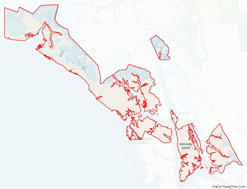
Skagway Municipality Road Map
Geography
Skagway is located at 59°28′7″N 135°18′21″W / 59.46861°N 135.30583°W / 59.46861; -135.30583 (59.468519, −135.305962).
Skagway is located in a narrow glaciated valley at the head of the Taiya Inlet, the north end of the Lynn Canal, which is the most northern fjord on the Inside Passage on the south coast of Alaska. It is in the Alaska panhandle 90 miles northwest of Juneau, Alaska’s capital city.
According to the U.S. Census Bureau, the borough has a total area of 464 square miles (1,200 km), of which 452 square miles (1,170 km) is land and 12 square miles (31 km) (2.5%) is water. It is currently the smallest borough in Alaska, having taken the title away from Bristol Bay Borough at its creation.
Adjacent boroughs
- Haines Borough, Alaska – south, west
- Stikine Region, British Columbia – north, east
National protected areas
- Klondike Gold Rush National Historical Park (part, also in Seattle, Washington)
- Tongass National Forest (part)
Climate
Skagway has a humid continental climate (Köppen Dsb). It is in the rain shadow of the coastal mountains, and though not as pronounced as the rain shadow in Southcentral Alaska in the valley of the Susitna River, this still allows it to receive only half as much precipitation as Juneau and only a sixth as much as Yakutat. Although winters are too cold for the classification, precipitation patterns resemble a mediterranean climate due to the summer precipitation minimum. The highest temperature recorded in Skagway is 92 °F or 33.3 °C in three separate years, most recently in 2019, and the lowest is −24 °F or −31.1 °C on February 2, 1947.
North winds prevail at Skagway from November to March. South winds prevail from April to October.
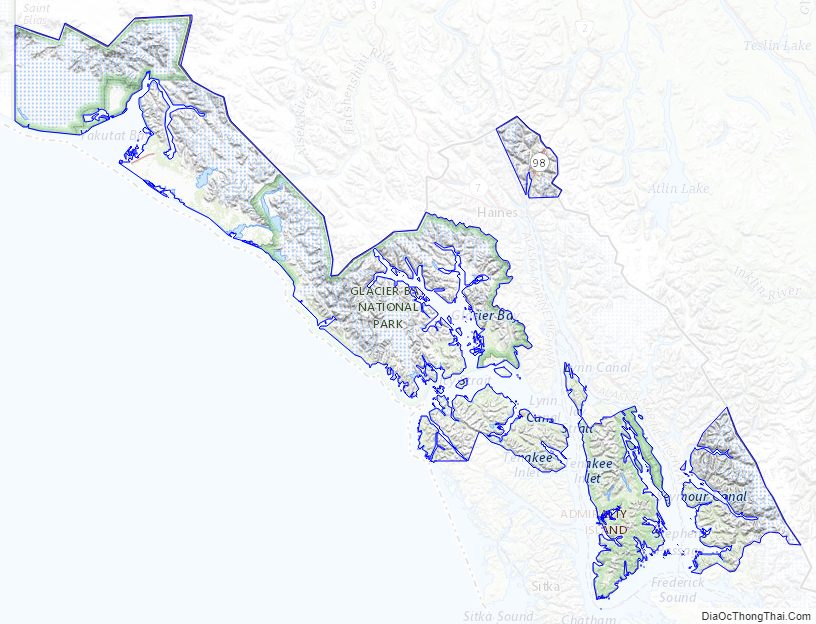
Skagway Municipality Topographic Map
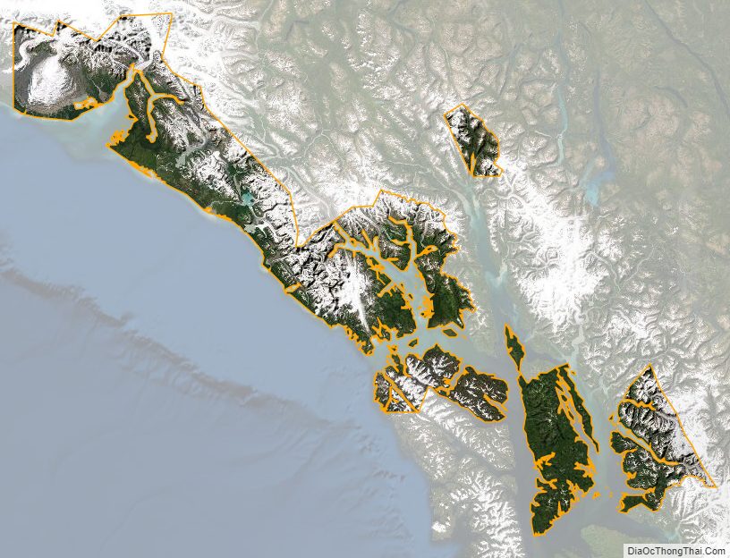
Skagway Municipality Satellite Map
Skagway Municipality Outline Map
See also
Map of Alaska State and its subdivision:- Aleutians East
- Aleutians West
- Anchorage
- Bethel
- Bristol Bay
- Denali
- Dillingham
- Fairbanks North Star
- Haines
- Juneau
- Kenai Peninsula
- Ketchikan Gateway
- Kodiak Island
- Lake and Peninsula
- Matanuska-Susitna
- Nome
- North Slope
- Northwest Arctic
- Prince of Wales-Outer Ketchi
- Sitka
- Skagway-Yakutat-Angoon
- Southeast Fairbanks
- Valdez-Cordova
- Wade Hampton
- Wrangell-Petersburg
- Yukon-Koyukuk
- Alabama
- Alaska
- Arizona
- Arkansas
- California
- Colorado
- Connecticut
- Delaware
- District of Columbia
- Florida
- Georgia
- Hawaii
- Idaho
- Illinois
- Indiana
- Iowa
- Kansas
- Kentucky
- Louisiana
- Maine
- Maryland
- Massachusetts
- Michigan
- Minnesota
- Mississippi
- Missouri
- Montana
- Nebraska
- Nevada
- New Hampshire
- New Jersey
- New Mexico
- New York
- North Carolina
- North Dakota
- Ohio
- Oklahoma
- Oregon
- Pennsylvania
- Rhode Island
- South Carolina
- South Dakota
- Tennessee
- Texas
- Utah
- Vermont
- Virginia
- Washington
- West Virginia
- Wisconsin
- Wyoming