Salt Lake County is located in the U.S. state of Utah. As of the 2020 United States census, the population was 1,185,238, making it the most populous county in Utah. Its county seat and largest city is Salt Lake City, the state capital. The county was created in 1850. Salt Lake County is the 37th most populated county in the United States and is one of four counties in the Rocky Mountains to make it into the top 100. (Others being Denver County and El Paso County, Colorado and Clark County, Nevada.) Salt Lake County is the only county of the first class in Utah – under the Utah Code (Title 17, Chapter 50, Part 5) is a county with a population of 700,000 or greater.
Salt Lake County occupies the Salt Lake Valley, as well as parts of the surrounding mountains, the Oquirrh Mountains to the west and the Wasatch Range to the east (essentially the entire Jordan River watershed north of the Traverse Mountains). In addition, the northwestern section of the county includes part of the Great Salt Lake. The county is noted for its ski resorts; Salt Lake City hosted the 2002 Winter Olympics. Salt Lake County is the central county of the Salt Lake City metropolitan area. Sustained drought in Utah has more recently strained Salt Lake County’s water security and has caused the Great Salt Lake level drop to record low levels.
| Name: | Salt Lake County |
|---|---|
| FIPS code: | 49-035 |
| State: | Utah |
| Founded: | January 31, 1850 |
| Named for: | Great Salt Lake |
| Seat: | Salt Lake City |
| Largest city: | Salt Lake City |
| Total Area: | 807 sq mi (2,090 km²) |
| Land Area: | 742 sq mi (1,920 km²) |
| Total Population: | 1,185,238 |
| Population Density: | 1,500/sq mi (570/km²) |
| Time zone: | UTC−7 (Mountain) |
| Summer Time Zone (DST): | UTC−6 (MDT) |
| Website: | slco.org |
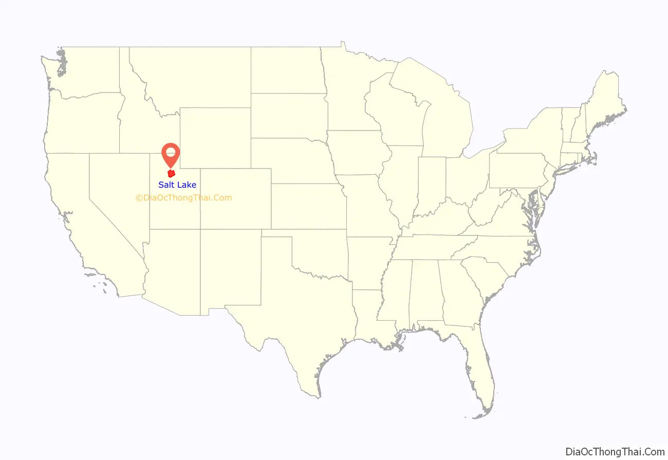
Salt Lake County location map. Where is Salt Lake County?
History
This area was occupied for thousands of years by cultures of indigenous peoples.
19th century
The future Salt Lake County area was settled by European Americans in 1847 when Mormon pioneers of the Church of Jesus Christ of Latter-day Saints fled religious persecution in the East. They arrived in the Salt Lake Valley after descending what settlers later called Emigration Canyon. Brigham Young, their leader, declared “This is the place” after seeing the valley. Compared to eastern regions, it seemed arid and unpromising to some of the migrants. Settlers used irrigation to develop agriculture and the flourishing, self-sufficient city known then as Great Salt Lake City. Thousands of Mormons joined them in the next several decades.
Settlers buried thirty-six Native Americans in one grave after an outbreak of measles occurred during the winter of 1847.
The initial territorial settlement was in Great Salt Lake City proper, but Brigham Young desired to secure a substantial population base across the then-uninhabited Great Basin, so he soon asked members to resettle farther out from the central point. They declared themselves a state (State of Deseret) in hopes of gaining admittance to the Union, and to assure the nascent state would grow uniformly, they named an as-yet-unbuilt settlement in mid-state as the state’s capital (Fillmore).
The county was officially organized on January 31, 1850, with slightly more than 11,000 residents recorded. In 1850, 26 slaves were counted in Salt Lake County. In 1852, the territorial legislature passed the Act in Relation to Service and the Act for the relief of Indian Slaves and Prisoners formally legalizing slavery in the territory.
Due to Utah Territory’s conflicts with the federal government, the federal surveyor abandoned his post in 1857, two years after he arrived. The surveyor’s duty was to officially plat the territory in order to bring the area onto the market, to make homesteading possible. The intermediate years between 1857 and 1869 passed with no federal surveyors, the LDS Pioneers completed plats, deeds, and surveys of the county in order to homestead and collect taxes. Since the deeds and titles handed out during the twelve-year period were not federally recognized homestead certificates, the Utah Territory agreed to reconcile the unrecognized deeds and titles in order to fold the Utah Territory into the federal homestead system, calling them (instead of homestead certificates) Land Title Certificates. The process to adjudicate the certificates took place over several years in 1871–1873, through the county Probate Court, overseen by judge Elias Smith. Settlers were required to file land claims, make declaratory statements, attend their adjudication hearings, provide testimony if counter claims on a parcel of land were filed, and wait for final judgement from the probate judge, who issued a final Land Title Certificate which declared a person the rightful owner. These certificates are retroactive backwards to 1852.
The idea of statehood for the new area was quickly tossed aside by the federal government, and the area was declared a territory in September 1850 – the Utah Territory. Construction of the capitol building in Fillmore was completed in 1855, so the territorial legislature traveled to the small community for their first session there. It was to be their last, as they chose to meet in Great Salt Lake City the following year and, in 1857, formally voted to make Salt Lake City (the shorter name adopted in 1857) the capital of the Territory. In 1858, when the Utah Territory was declared in rebellion, the federal government sent troops to install a new governor and keep watch over the area. The government transition was made peacefully, then the troops set up Camp Floyd to the south in Utah County. In 1862, Fort Douglas was established on the eastern bench, near the current site of the University of Utah, as the federal government wanted to ensure the loyalty of the territory during the American Civil War.
Patrick Edward Connor, the leader of the garrison at Fort Douglas, was openly anti-Mormon. He sent out parties to scout for mineral resources in the nearby mountains, hoping to encourage non-Mormons to settle in the territory. During the late 19th century, mines were established in the Wasatch mountains, most notably around Alta (and nearby Park City in Summit County). Exploiting the mineral wealth was difficult until the Utah Central Railroad was constructed and reached this area in 1870.
In the Oquirrh Mountains, the Bingham Canyon Mine, which contains vast deposits of copper and silver, was developed as the most productive of the county’s mines. The mine, located in the southwest portion of the county, attracted thousands of workers to the narrow canyon. At its peak, the city of Bingham Canyon contained 20,000 residents, all crowded along the steep walls of the canyon, and natural disasters were a frequent occurrence. By the early 20th century, most of the mines in the county had closed. However, the Bingham Canyon Mine kept on expanding. In the early 21st century, it is among the largest open-pit mines in the world.
20th century
After the railroad came to the county, the population began to expand more rapidly, and non-Mormons began to settle in Salt Lake City. During the early 20th century, the heavy industry came to the valley as well, diversifying its economy. Local and interurban trolley systems were built covering the more urban northeastern quarter of the valley. The city dismantled the trolley system by 1945, favoring the use of individual cars. Throughout the late 19th and early 20th centuries, the east side of the valley began to be more densely settled.
In 1942, Kearns Army Air Base, a large military installation developed for World War II, was located in what is now Kearns on the western side of the valley. After the camp was closed in 1946, the land was sold for private development. Rapid postwar residential settlement of the area began. The federal government established other major defensive installations along the Wasatch Front and in the Great Salt Lake Desert during World War II, which stimulated the economy and brought more people to the area, establishing Utah as a major military center that benefited from federal investment. In the nationwide suburban boom of the late 1940s, 1950s, and early 1960s, such cities as South Salt Lake, Murray, Midvale, and much of the east side of the valley grew rapidly.
In common with other industrialized cities, Salt Lake City faced inner-city decay in the 1960s, when residents moved to newer housing in the suburbs. Cities such as Sandy, West Jordan, and what would become West Valley City grew at boomtown rates in the 1970s and 1980s. Huge residential tracts were developed through the center of the valley, and within ten years, the entire area had been converted from farmland into sprawling bedroom communities in Salt Lake City. West Valley City was created from the merger of the three unincorporated cities of Granger, Hunter and Redwood (including Chesterfield) in 1980.
But not every area of the county saw growth. The former mining towns related to Bingham Canyon were abandoned in the 1960s and 1970s to make way for the expansion of the open-pit mine. The city of Bingham Canyon was completely torn down and swallowed up in the mine by 1972, and the dismantling of Lark in 1980 completed the process. The only remaining mining town in the county is Copperton, located southwest of West Jordan, with approximately 800 residents. Magna has workers who continue to be associated with the mine’s smelting operations in Garfield and at Arthur Mill.
In the 1990s, the county’s areas of rapid growth shifted further south and west. Farm and pasturelands were developed as suburbs. The cities of West Jordan, South Jordan, Riverton, Herriman, and Draper are some of the fastest-growing cities in the state. During the 1990s, Salt Lake City gained population for the first time in 40 years. Salt Lake City’s selection as the host of the 2002 Winter Olympics spurred a construction boom in the city that continued after the Olympics, slowing only in 2008 recession. As the county’s population has surpassed 1 million, the main issue it faces is urbanization. Only a few small rural areas remain in the far west of the valley. Other issues facing the county today include congested transportation and related air pollution.
21st century
According to data from the LDS Church and the State of Utah, Salt Lake County was 50.6% LDS (Mormon) in 2008, as reported in the Deseret News. By 2013, this had increased to 51.41%. However, by 2018, this had decreased to 48.91%, making Salt Lake County a majority non-Mormon county. Sustained drought in Utah has progressively strained Salt Lake County’s water security in the 21st century and has caused the Great Salt Lake level drop to record low levels.
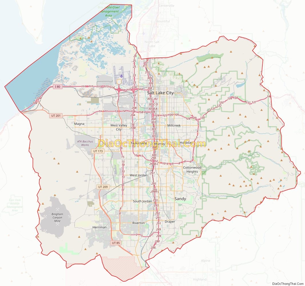
Salt Lake County Road Map
Geography
The Salt Lake Valley is fed by seven streams from the surrounding mountains. All the runoff water eventually ends in the Great Salt Lake, which has no outlet. The mountains rise precipitously from the relatively flat valley surfaces, indicating their comparatively youthful formation. The county has a total area of 807 square miles (2,090 km), of which 742 square miles (1,920 km) is land and 65 square miles (170 km) (8.1%) is water. It is the fifth-smallest county in Utah by area. The county borders on the Great Salt Lake and is traversed by the northward flowing Jordan River.
The western portion of the county descends toward the valley of the lake, but perhaps the most dominating physical feature in Salt Lake County is the Wasatch Mountains in the eastern portion of the county, famous for both summer and winter activities. The mountains are administered as part of the Wasatch-Cache National Forest. The mountains’ snow is touted in state-sponsored publicity as ‘Greatest Snow on Earth’ for its soft, powdery texture, and led to Salt Lake City‘s winning the bid for the 2002 Winter Olympics. Salt Lake County has four ski resorts: Snowbird and Alta in Little Cottonwood Canyon and Solitude and Brighton in Big Cottonwood Canyon. Hiking and camping are popular summer activities. The Oquirrh Mountains border the western part of the county. These two mountain ranges, together with the much smaller Traverse Mountains at the south of the valley, delimit Salt Lake Valley, which is also flanked on the northwest by the Great Salt Lake, and on the north by the Salt Lake Anticline (including Ensign Peak).
On the north and east benches, houses have been built halfway up the mountain to the boundary of the national forest, assuming greater risk from wildfires. New communities are also being constructed on the southern and western slopes. Rapid residential construction continues in the west-central, southwest, and southern portions of the valley. In the far west, southwest, and northwest, rural areas still exist, but rapid growth threatens what remains of the natural environment in the valley. The County government operates several large parks in the valley (including some with incorporated cities), including Big Cottonwood Park, Crestwood Park, and an Equestrian Center.
Access
Traffic into the Salt Lake Valley passes through four narrow geographic features: Parley’s Canyon to the east; the space between the Salt Lake Anticline and the Great Salt Lake leading into Davis County to the north; the Point of the Mountain and adjacent Jordan Narrows leading to Utah County to the south; and a space (known as Garfield) between the Oquirrh Mountains and the Great Salt Lake leading to Tooele County to the west. Of these, only the connection to Davis County to the north is wide enough and flat enough to accommodate transportation routes without reliance on earthworks.
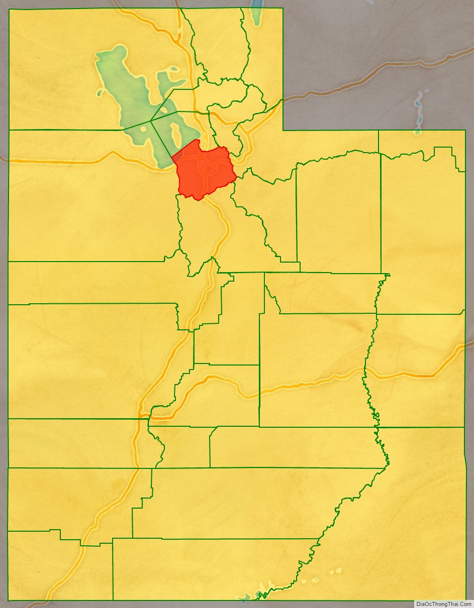
Adjacent counties
- Davis County – north
- Morgan County – northeast
- Summit County – east
- Wasatch County – southeast
- Utah County – south
- Tooele County – west
Climate
Annual precipitation for the Salt Lake Valley is around 15 inches (380 mm), usually with more on the east side and less on the west side, as most storms come from the Pacific Ocean and the west side is in the rain shadow of the Oquirrh Mountains. Up to 19 inches (480 mm) is received on the east benches. Most of this precipitation is received in spring. The summer is dry, with the majority of precipitation arriving from the monsoon that rises from the south. Short, localized, and often dry thunderstorms are usually associated with the monsoon. However, some can be very intense. These storms can cause contrasting emergencies of flash floods and wildfires (due to dry lightning and powerful winds). Precipitation is heaviest in late fall/early winter and in spring, while early summer is the driest season.
Annual snowfall in the valley is 55 inches (140 cm), with up to 100 inches (250 cm) on the benches. The most snow falls between mid-November and late March. The mountains receive up to 500 inches (1,300 cm) of light, dry snow and up to 55 inches (140 cm) of precipitation annually. The dry snow is often considered good for skiing, contributing to the four ski resorts in the county. Snow usually falls from October through May. The heavy snow totals across the county can be attributed to the lake-effect, where precipitation is intensified by the warm waters of the Great Salt Lake, which never entirely freezes due to the lake’s high salinity. The lake effect can affect any area of the county, depending on wind conditions. The dry snow is attributed to the low humidity of the region.
During winter, temperature inversions are common, causing air pollution in the valley. They trap pollutants, moisture, and cold temperatures in the valley while the surrounding mountains enjoy warm temperatures and clear skies. This can cause some melting snow in the mountains and unhealthy air quality, and low visibility in the valley. This weather event lasts from a few days to a month in extreme cases and is caused when an area of high-pressure over the Great Basin.
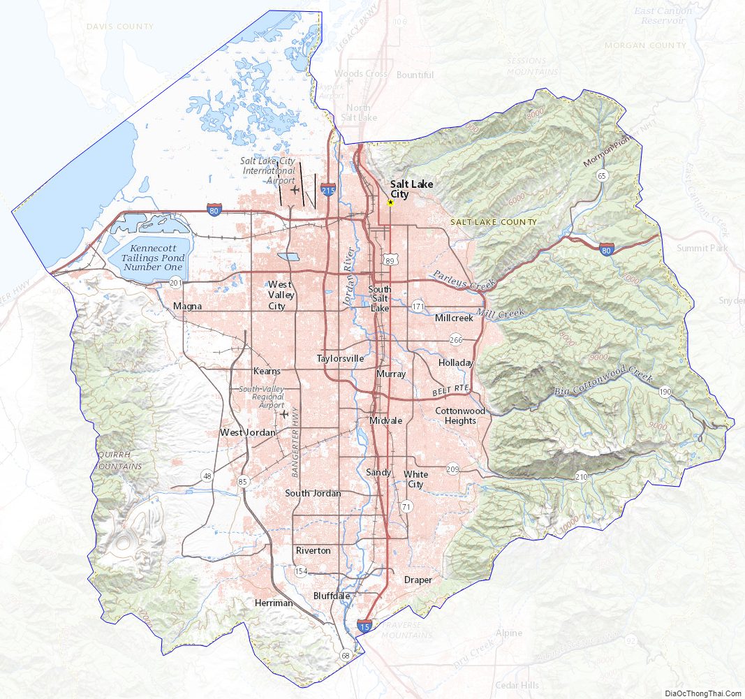
Salt Lake County Topographic Map
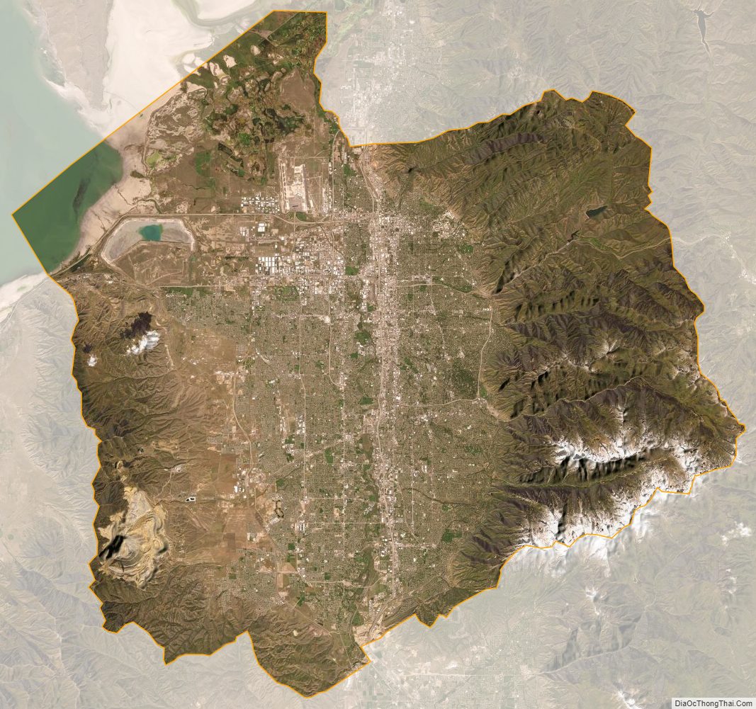
Salt Lake County Satellite Map
Salt Lake County Outline Map