Murray (/ˈmʌri/) is a city situated on the Wasatch Front in the core of Salt Lake Valley in the U.S. state of Utah. Named for territorial governor Eli Murray, it is the state’s fourteenth largest city. According to the 2020 census, Murray had a population of 50,637. Murray shares borders with Taylorsville, Holladay, South Salt Lake and West Jordan, Utah. Once teeming with heavy industry, Murray’s industrial sector now has little trace and has been replaced by major mercantile sectors. Known for its central location in Salt Lake County, Murray has been called the Hub of Salt Lake County. Unlike most of its neighboring communities, Murray operates its own police, fire, power, water, library, and parks and recreation departments and has its own school district. While maintaining many of its own services, Murray has one of the lowest city tax rates in the state.
Thousands of people each year visit Murray City Park for organized sports and its wooded areas. Murray is home to the Intermountain Medical Center, a medical campus that is also Murray’s largest employer. Murray has been designated a Tree City USA since 1977.
| Name: | Murray city |
|---|---|
| LSAD Code: | 25 |
| LSAD Description: | city (suffix) |
| State: | Utah |
| County: | Salt Lake County |
| Incorporated: | January 3, 1903 |
| Elevation: | 4,301 ft (1,311 m) |
| Total Area: | 12.32 sq mi (31.92 km²) |
| Land Area: | 12.32 sq mi (31.91 km²) |
| Water Area: | 0.00 sq mi (0.01 km²) |
| Total Population: | 50,637 |
| Population Density: | 4,110.15/sq mi (1,532.75/km²) |
| ZIP code: | 84107, 84117, 84121, 84123 |
| Area code: | 385, 801 |
| FIPS code: | 4953230 |
| GNISfeature ID: | 1443742 |
| Website: | www.murray.utah.gov |
Online Interactive Map
Click on ![]() to view map in "full screen" mode.
to view map in "full screen" mode.
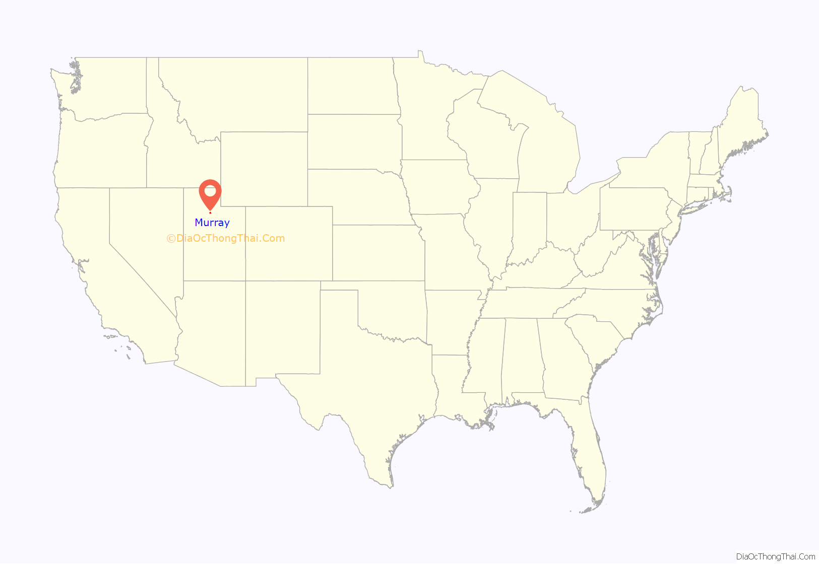
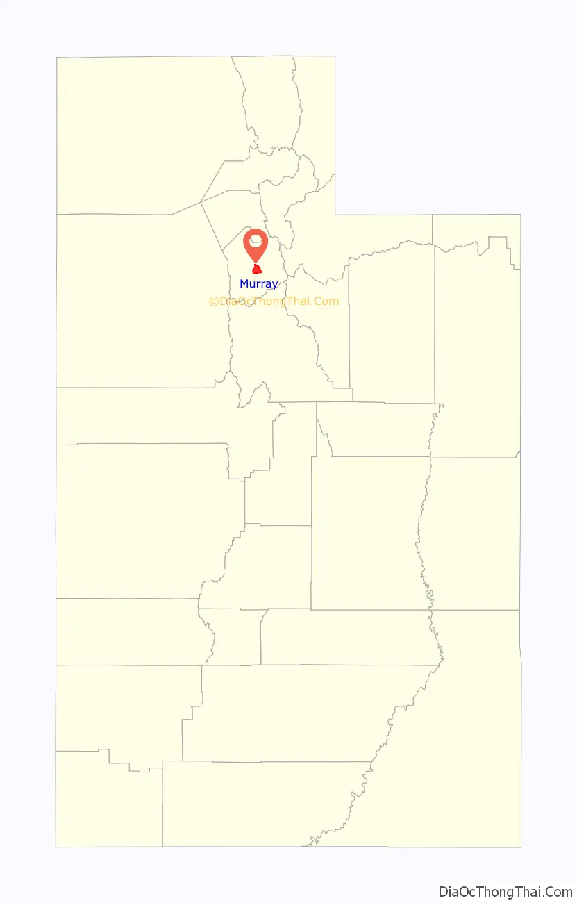
Murray location map. Where is Murray city?
History
Pre-settlement
Before being permanently settled by Mormon pioneers in 1848, the area where Murray is located was a natural area that served as the seasonal home of Paiute, Shoshone, and Bannock Native American tribes. The tribes camped along local creek banks and stream beds during their migrations. Artifacts of Native American encampments have been located along the Jordan River, including camps near Willow Pond Park.
At what was known as the “big bend” of the Jordan River (near 4984 South 700 West Street), the Goshute Indians from Skull Valley made their camp. This was made every spring on the way to their hunting ground at the headwaters of the Bear River. On their return in the fall, they also stayed for a week and traded with white settlers. Early settlers recorded that they generally traded buffalo robes, deer skins, dried meat and tallow.
A new settlement
Mormon pioneers came into the Salt Lake Valley in 1847. A pioneer group that was called the Mississippi Saints arrived one year later and began to develop a scattered settlement in the south end of the valley that fall. The area was distinguished by various names, such as the Mississippi Ward, Cottonwood, Big Cottonwood and South Cottonwood. Written history states that at least 20 families were living in the South Cottonwood area in the 1860s.
When the first pioneer families settled in the South Cottonwood area in the fall of 1848, they selected the low or bottom lands along the streams of Little Cottonwood Creek and Big Cottonwood Creek. They found an abundance of grass for their cattle and horses there. It was easy to take the water from the streams for irrigation of farm crops. The higher bench lands were covered with sagebrush and produced very little grass. Because of the labor and difficulty in getting water to them, they were left, for later settlement.
There was a strip of high bench land, completely surrounded by low land north of what is now Vine Street and 5600 South Street. Before and after the advent of the pioneers, this land was used by the Ute Indians as a camping ground. This is because water and grass could be obtained on either side of it and enemies could not approach without being seen long before coming to the high ground. This area would become the present-day Murray City Cemetery. The early settlers mutually agreed that no individual should fence or take title to it, but that it should be set aside and considered as belonging to South Cottonwood Ward.
In 1853, when teamsters commenced to haul granite rock from Little Cottonwood Canyon to the Salt Lake Temple construction site, a dirt path was made along what is now Vine Street. The east side of the road (at the northeast corner, where the Stillwater Apartments now stand) became a halfway camping ground for the teamsters. The first building in the Salt Lake Valley outside of Salt Lake City erected for the purpose of religious and educational instruction was built on present-day Gordon Lane, and is commemorated with a monument from the Sons of the Utah Pioneers.
In 1858, during the so-called Utah War, Albert Sidney Johnston’s army of the Utah Expedition passed through western Murray after camping on the “flats” above the North Jordan farms. Its large livestock herd reportedly ate everything to within an inch of the ground. General Johnston, who was crossing James Winchester’s property (now Murray Parkway Golf Course), advised Winchester to pursue a homestead patent. In 1870 James Winchester entered the first homestead of the entire Intermountain West.
The Pony Express traveled through central Murray, along what is now State Street. The Utah Pony Express Station Number 9 was located near present-day 6200 State Street and was called “Travelers’ Rest”, but the accommodations were meager, consisting of a stable and one-room bunk house. The Overland Stagecoach later made use of Travelers’ Rest during its period of operation. The Sons of Utah Pioneers erected a monument at 7200 State Street in Midvale commemorating the station.
The area remained agricultural until 1869 when a body of ore was found in Park City, Utah, and additional ore deposits were found in Little Cottonwood Canyon. Because of Murray’s central location and access to the railroad, the first smelter was built there in 1870 and over the next 30 years Murray became home to some of the largest smelters of gold, silver, copper, lead and zinc in the region.
The first official post office was established in 1870 as the South Cottonwood Post Office. The area changed over time as the railroad came in, smelting expanded, the territorial road (later known as State Street) was established, and trolley transportation was developed. A business district also began to develop along the transportation corridor. (See also Murray Downtown Historic District and Murray Downtown Residential Historic District.)
The army established Camp Murray in 1885 to house several companies of the Ninth Infantry Regiment. The army camp was meant to help protect the railroad and provide training. The short-lived camp’s most notable action was when General Alexander McDowell McCook and six divisions of the camp were ordered to escort Chinese nationals out of Evanston, Wyoming, due to the race riots that were happening among miners in Rock Springs, Wyoming. The camp was disbanded in the early 20th century.
The city received its present name from the post office, which had officially changed its name from South Cottonwood Post Office to Murray Post Office in 1883, after the Civil War general, Eli Murray, territorial governor of Utah from 1880 to 1886.
After a riot and fire were started by a rowdy group of smelter workers in a local saloon, a local newspaper editor began agitating for the settlement to be incorporated. The final incorporation committee drafted a petition in 1901 and created an intense campaign on both sides of the incorporation battle. An incorporation election was held on November 18, 1902. Those in favor won, and C.L. Miller was elected Mayor by a margin of three votes. Salt Lake County recognized the election results as official on November 25, 1902, and the city was officially recognized as a Third Class City by the State of Utah on January 3, 1903.
Center of industry
Murray’s central location in Salt Lake Valley made it a convenient location for industry. Construction of the Woodhill Brothers’ smelter in 1869 initiated Murray’s industrial history. In 1870, Murray produced the first silver bars smelted in Utah. In 1899, American Smelting & Refining Company (ASARCO) was organized by combining the Germania and Hanauer smelters. The smelters continued to dominate the local economy until the close of the ASARCO lead smelter in 1949. Business and commercial enterprise prospered along with the smelter industry. Murray’s industry would later include a water plant, lighting system, canning factory, flour mills, and brickyards. Many of those employed at the Franklyn and Germania smelters were immigrants from Scandinavian countries who had joined the LDS church in their homeland and moved to Utah; most spoke little English. The Scandinavian population settled in the area west of State Street and was large enough to hold separate LDS services in the Swedish language. (See Murray LDS Second Ward Meetinghouse). The Scandinavians eventually dispersed, and with the exception of their meetinghouse, few ethnic reminders remain in this section of Murray. Joe Hill, the Industrial Workers of the World labor activist came to Murray in 1914 to rally laborers working at the smelters and nearby mines. He was arrested for a double homicide in Salt Lake City while recovering from a gunshot wound at the Murray home of Edward and John Eselius, that was located on 4800 South (then known as 17th South St.) and Plum Street.
“Bergertown”, a cluster of homes south of 4800 South Street on Little Cottonwood Creek, was settled by Swiss immigrant Christian Berger prior to the town’s industrialization. Simple small two-room frame houses without paint and running water characterized this side of town. Bergertown quickly became an immigrant enclave, as the population were mainly employees of the smelters. A few original homes remain among modern retail establishments.
In addition to the impact of lawsuits due to the spread of lead dust, Murray’s industry suffered greatly in the 1930s depression. The smelters began to close in 1931, and major industry had nearly vanished by 1940. By the 1950s the industry was completely gone. Murray was quick to take advantage of various federal projects to compensate for this economic loss. In 2000, to avoid designation as a Superfund site, the landmark ASARCO Smelters were imploded, and Intermountain Healthcare purchased the site for its Intermountain Medical Center. As landmarks, the smelters are remembered in Murray’s logos and trademarks.
Post–World War II to present
With the demise of heavy industry prior to World War II, and the advent of the Interstate Freeway System in the 1950s, Murray became a major retail hub due to its central location. State Street is dominated by automobile dealerships, where auto magnate, Larry H. Miller, purchased his first dealership May 1, 1979, as Larry H. Miller Toyota.
Fashion Place Mall was constructed in the 1970s. It is now a major mercantile center which saw major renovation and expansion in the first decade of the 21st century. The mall achieved some fame after serial killer Ted Bundy’s murder spree temporarily came to an end when he tried to lure Carol DaRonch into his car at the mall on November 8, 1974. DaRonch fought Bundy, escaped from his car, and survived to testify against him in court.
Cottonwood Hospital opened in the 1960s, receiving numerous recognitions. Replaced by Intermountain Medical Center (IMC) in 2007, it spawned The Orthopedic Specialty Hospital (TOSH) in the 1990s.
As part of the construction of the Utah Transit Authority’s (UTA) TRAX light-rail line in the 1990s, three stations were built in Murray along the primary route (the Blue Line). The Fireclay Housing Project received national recognition for its use of creating development around the Murray North station as a Transit-Oriented Development (TOD). Murray’s Fashion Place West station is the junction for the Red Line (Mid-Jordan Line) light-rail spur. In 2012 FrontRunner commuter rail service was extended to the Murray Central station.
In the mid-2000s, people of the census-designated place (CDP), Cottonwood West, petitioned for annexation into Murray, increasing the population by 17,000, nearly one-third more than in the 2000 census. Murray’s eastern boundary, along 900 East, was extended as a result of the annexation to Van Winkle Expressway and Highland Drive, along the city borders of Holladay and Cottonwood Heights.
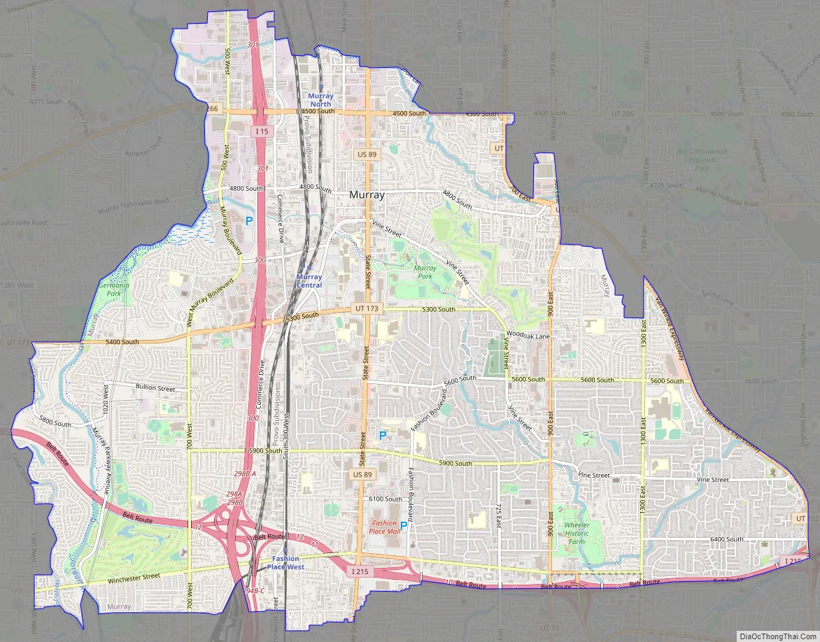
Murray Road Map
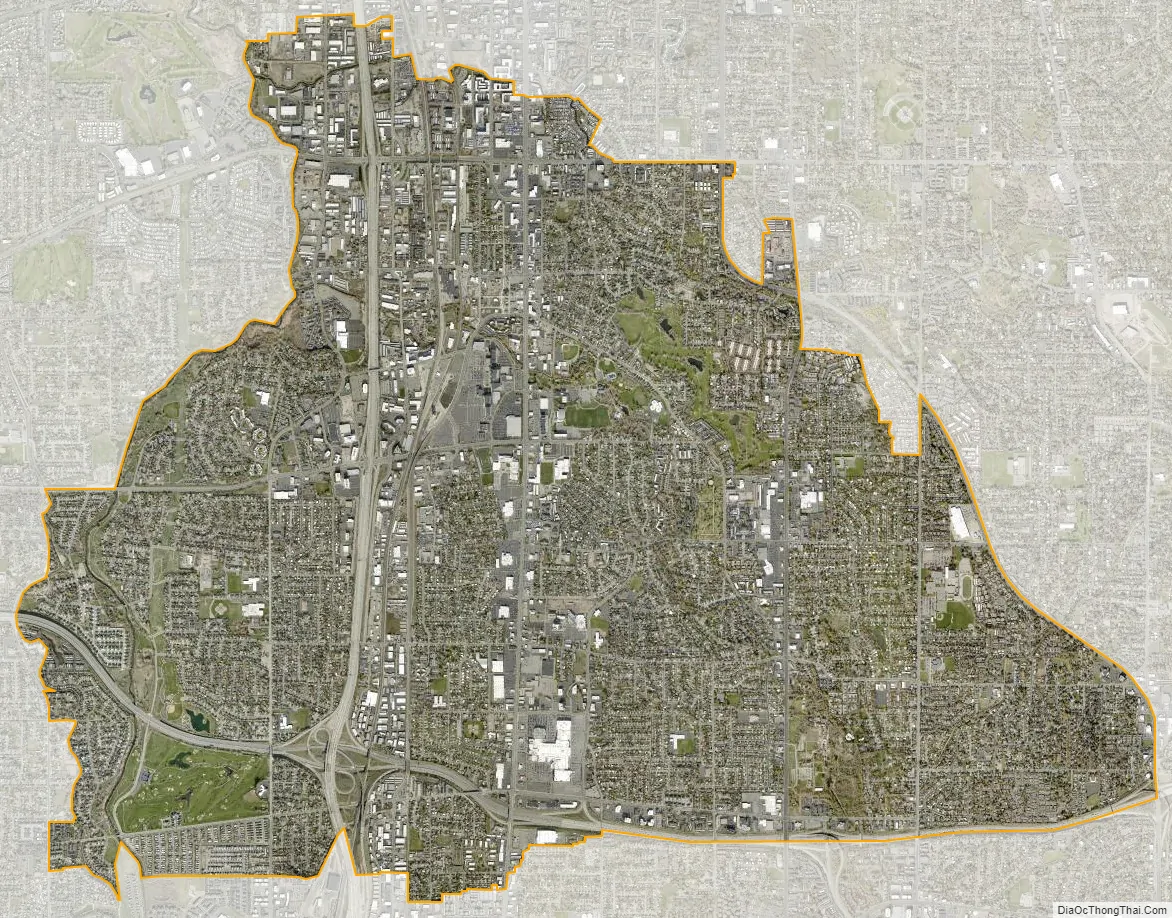
Murray city Satellite Map
Geography
Topography
According to the United States Census Bureau, the city has a total area of 9.6 square miles (24.9 km), all land. Murray is located in the heart of the Salt Lake Valley. The city is nearly built out with a broad mix of commercial, residential and industrial uses. The topography is generally gentle, sloping westward from the nearby Wasatch Mountain Range toward the Jordan River, which is the terminal river feature in the Salt Lake Valley. Murray’s average altitude is approximately 1300 meters Above Sea Level, with the highest variation located near the border of Cottonwood Heights and lowest variation along the Jordan River near 4500 South Street.
Lying at the base of the Wasatch Mountains, and located approximately three miles to the east of Murray, in neighboring Holladay, is the Wasatch Fault. Liquefaction is a particular danger to Murray because of the close proximity of the Wasatch fault. Soil liquefaction potential, according to the Utah Geological Survey, estimates that the majority of Murray is in either High or Moderate Liquefaction zones. City policies are in place to minimize the potential impacts on structures.
Hydrology
The Jordan River is the largest water feature within Murray. It traverses the western edge of Murray, where it eventually reaches the Great Salt Lake. Murray administers a trail and green area that borders the river through the whole city. Big Cottonwood and Little Cottonwood Creeks join the Jordan River within Murray boundaries, following routes between properties, along streets, and through parks and open spaces. Significant wetlands adjoin the river and these two creeks.
Murray contains only small lakes. Willow Pond and Turner Pond are the largest natural lakes within the city limits. Willow Pond is the only lake that permits public access, and is stocked with fish. Several man-made lakes have been created in the Lynn Pett Murray Parkway and Mick Riley Golf Courses. Other lakes are small and are contained within Murray’s wetland areas.
Climate
Murray has a Mediterranean climate (Köppen Csa).
See also
Map of Utah State and its subdivision: Map of other states:- Alabama
- Alaska
- Arizona
- Arkansas
- California
- Colorado
- Connecticut
- Delaware
- District of Columbia
- Florida
- Georgia
- Hawaii
- Idaho
- Illinois
- Indiana
- Iowa
- Kansas
- Kentucky
- Louisiana
- Maine
- Maryland
- Massachusetts
- Michigan
- Minnesota
- Mississippi
- Missouri
- Montana
- Nebraska
- Nevada
- New Hampshire
- New Jersey
- New Mexico
- New York
- North Carolina
- North Dakota
- Ohio
- Oklahoma
- Oregon
- Pennsylvania
- Rhode Island
- South Carolina
- South Dakota
- Tennessee
- Texas
- Utah
- Vermont
- Virginia
- Washington
- West Virginia
- Wisconsin
- Wyoming