Contra Costa County (/ˌkɒntrə ˈkɒstə/ (listen); Contra Costa, Spanish for “Opposite Coast”) is a county located in the U.S. state of California, in the East Bay of the San Francisco Bay Area. As of the 2020 United States Census, the population was 1,165,927. The county seat is Martinez. It occupies the northern portion of the East Bay region of the San Francisco Bay Area and is primarily suburban. The county’s name refers to its position on the other side of the bay from San Francisco. Contra Costa County is included in the San Francisco–Oakland–Berkeley, CA Metropolitan Statistical Area.
| Name: | Contra Costa County |
|---|---|
| FIPS code: | 06-013 |
| State: | California |
| Founded: | 1850 |
| Named for: | “Opposite coast” (Spanish: Contra costa) of the San Francisco Bay |
| Seat: | Martinez |
| Largest city: | Concord (population and land area) Richmond (total area) |
| Total Area: | 804 sq mi (2,080 km²) |
| Land Area: | 715.94 sq mi (1,854.3 km²) |
| Total Population: | 1,165,927 |
| Population Density: | 1,629/sq mi (629/km²) |
| Time zone: | UTC−8 (Pacific Time Zone) |
| Summer Time Zone (DST): | UTC−7 (Pacific Daylight Time) |
| Website: | www.contracosta.ca.gov |
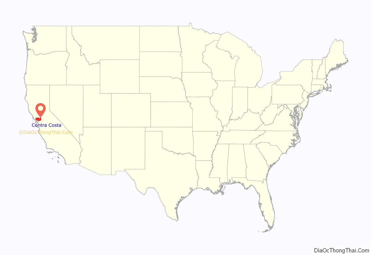
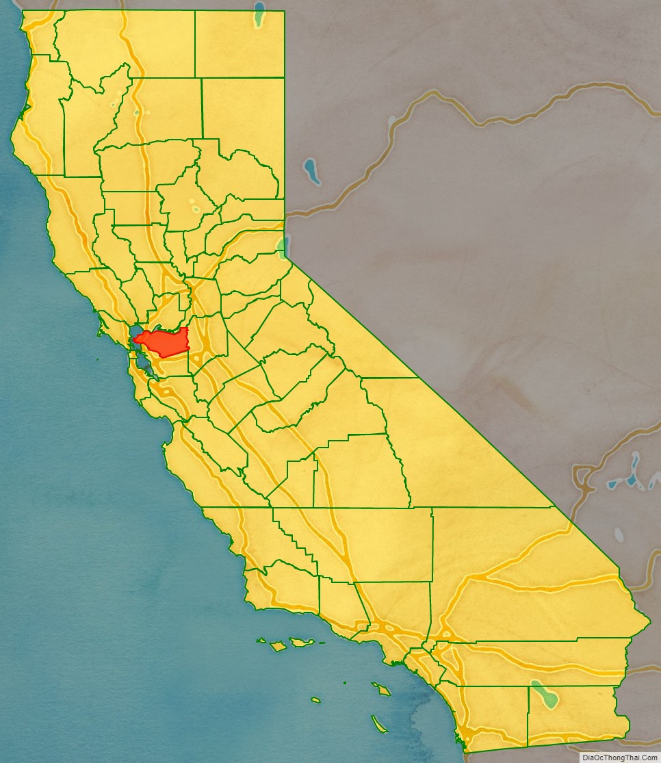
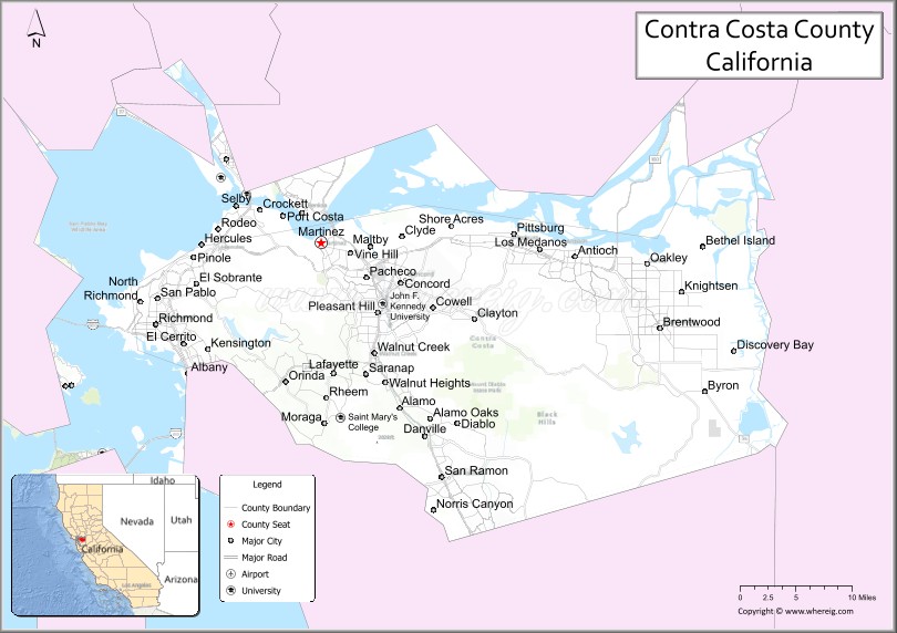
Contra Costa County location map. Where is Contra Costa County?
History
Pre-human
In prehistoric times, particularly the Miocene epoch, portions of the landforms now in the area (then marshy and grassy savanna) were populated by a wide range of now extinct mammals, known in modern times by the fossil remains excavated in the southern part of the county. In the northern part of the county, significant coal and sand deposits were formed in even earlier geologic eras. Other areas of the county have ridges exposing ancient but intact (not fossilized) seashells, embedded in sandstone layers alternating with limestone. Layers of volcanic ash ejected from geologically recent but now extinct volcanoes, compacted and now tilted by compressive forces, may be seen at the site of some road excavations. This county is an agglomeration of several distinct geologic terranes, as is most of the greater San Francisco Bay Area, which is one of the most geologically complex regions in the world. The great local mountain Mount Diablo has been formed and continues to be elevated by compressive forces resulting from the action of plate tectonics and at its upper reaches presents ancient seabed rocks scraped from distant oceanic sedimentation locations and accumulated and lifted by these great forces. Younger deposits at middle altitudes include pillow lavas, the product of undersea volcanic eruptions.
Native American period
There is an extensive but little-recorded human history pre-European settlement in this area, with the present county containing portions of regions populated by a number of Native American tribes. The earliest definitively established occupation by modern man (Homo sapiens) appears to have occurred six to ten thousand years ago. However, there may have been human presence far earlier, at least as far as non–settling populations are concerned. The known settled populations were hunter-gatherer societies that had no knowledge of metals and that produced utilitarian crafts for everyday use (especially woven reed baskets) of the highest quality and with graphic embellishments of great aesthetic appeal. Extensive trading from tribe to tribe transferred exotic materials such as obsidian (useful for the making of arrowheads and other stone tools) throughout the region from far distant Californian tribes. Unlike the nomadic Native American of the Great Plains it appears that these tribes did not incorporate warfare into their culture but were instead generally cooperative. Within these cultures the concept of individual or collective land ownership was nonexistent. Early European settlers in the region, however, did not record much about the culture of the natives. Most of what is known culturally comes from preserved contemporaneous and excavated artifacts and from inter-generational knowledge passed down through northerly outlying tribes of the larger region.
Spanish colonial
Early interaction of these Native Americans with Europeans came with the Spanish colonization via the establishment of missions in this area, with the missions in San Jose, Sonoma, and San Francisco and particularly the establishment of a Presidio (a military establishment) in 1776. Although there were no missions established within this county, Spanish influence here was direct and extensive, through the establishment of land grants from the King of Spain to favored settlers.
Mexican land grants
In 1821 Mexico gained independence from Spain. While little changed in ranchero life, the Mexican War of Independence resulted in the secularization of the missions with the re-distribution of their lands, and a new system of land grants under the Mexican Federal Law of 1824. Mission lands extended throughout the Bay Area, including portions of Contra Costa County. Between 1836 and 1846, during the era when California was a province of independent Mexico, the following 15 land grants were made in Contra Costa County.
The smallest unit was one square league, or about seven square miles, or 4,400 acres (17.8 square kilometers), maximum to one individual was eleven leagues, or 48,400 acres (195.9 km), including no more than 4,428 acres (17.9 km) of irrigable land. Rough surveying was based on a map, or diseño, measured by streams, shorelines, and/or horseman who marked it with rope and stakes. Lands outside rancho grants were designated el sobrante, as in surplus or excess, and considered common lands. The law required the construction of a house within a year. Fences were not required and were forbidden where they might interfere with roads or trails. Locally a large family required roughly 2000 head of cattle and two square leagues of land (fourteen square miles) to live comfortably. Foreign entrepreneurs came to the area to provide goods that Mexico could not, and trading ships were taxed.
- Rancho Cañada de los Vaqueros was granted to Francisco Alviso, Antonio Higuera, and Manuel Miranda (26,660 acres (107.9 km) confirmed in 1889 to heirs of Robert Livermore).
- Two ranchos, both called Rancho San Ramon, were granted by the Mexican government in the San Ramon Valley. In 1833, Bartolomé Pacheco (southern San Ramon Valley) and Mariano Castro (northern San Ramon Valley) shared the two square league Rancho San Ramon. José María Amador was granted a four square league Rancho San Ramon in 1834.
- In 1834 Rancho Monte del Diablo (present day Concord, California) was confirmed with 17,921 acres (72.5 km) to Salvio Pacheco (born July 15, 1793, died 1876). The Pacheco family settled at the Rancho in 1846 (between the Pacheco shipping port townsite and Clayton area, and including much of Lime Ridge). The boundary lines were designated with stone markers. Clayton was later located on El Sobrante’s lands just east of Rancho Monte del Diablo (Mount Diablo).
- In 1834, Rancho Arroyo de Las Nueces y Bolbones, aka Rancho San Miguel (present day Walnut Creek), was granted to Juana Sanchez de Pacheco, in recognition of the service of Corporal Miguel Pacheco 37 years earlier (confirmed 1853, patented to heirs 1866); the grant was for two leagues, but drawn free hand on the diseño/map, and reading “two leagues, more or less” as indicated in the diseño, but actually including and confirmed for nearly four leagues or nearly 18,000 acres (72.8 km), but only 10,000 acres (40.5 km) were ever shown as having once belonged to Juana Sanchez.
- ‘Meganos’ means ‘sand dunes.’ A “paraje que llaman los Méganos” ‘place called the sand dunes’ (with a variant spelling) is mentioned in Durán’s diary on May 24, 1817. Two Los Meganos Ranchos were granted, later differentiated as Rancho Los Meganos (1835, three leagues or at least 13,285 acres (53.8 km)) in what is now the Brentwood area, to Jose Noriega then acquired by John Marsh; and Rancho Los Medanos (to Jose Antonio Mesa and Jose Miguel Garcia, Pittsburg area, dated November 26, 1839).
Bear Flag Republic and statehood
The exclusive land ownership in California by the approximate 9,000 Hispanics in California would soon end. John Marsh, owner of Rancho Los Meganos in Contra Costa County, had a lot to do with this. He sent letters to influential people in the eastern United States extolling the climate, soil, and potential for agriculture in California, with the deliberate purpose of encouraging Americans to immigrate to California and lead to its becoming part of the United States. He succeeded. His letters were published in newspapers throughout the East and started the first wagon trains rolling toward California. He also invited them to stay on his ranch until they could get settled, so the Rancho Los Meganos became the terminus of the California trail.
This led to the Bear Flag Revolt in 1846 when about 30 settlers originally from the United States declared a republic in June 1846 and were enlisted and fighting under the U.S. flag by July 1846. Following the Mexican–American War of 1846–48, California was controlled by U.S. settlers organized under the California Battalion and the U.S. Navy’s Pacific Squadron. After some minor skirmishes, California was under U.S. control by January 1847 and formally annexed and paid for by the U.S. in 1848. By 1850, California’s population of over 100,000 was rapidly growing due to the gold rush and the large amount of gold being exported east, which gave California enough clout to choose its own boundaries, write its own constitution, and be admitted to the Union as a free state in 1850 without going through territorial status as required for most other states.
In 1850 California had a non-Indian population of over 100,000. The number of Indians living in California in 1850 has been estimated to be from 60,000 to 100,000. By 1850 the Mission Indian populations had largely succumbed to disease and abuse and only numbered a few thousand. California’s 1852 state Census gives 31,266 Indian residents, but this is an under-count since there was little incentive and much difficulty in getting it more correct.
County creation
Contra Costa County was one of the original 27 counties of California, created in 1850 at the time of statehood. The county was originally to be called Mt. Diablo County, but the name was changed prior to incorporation as a county. The county’s Spanish language name means opposite coast, because of its location opposite San Francisco, in an easterly direction, on San Francisco Bay. Southern portions of the county’s territory, including all of the bayside portions opposite San Francisco and northern portions of Santa Clara County, were given up to form Alameda County effective March 25, 1853.
The land titles in Contra Costa County may be traced to multiple subdivisions of a few original land grants. The grantee’s family names live on in a few city and town names such as Martinez, Pacheco and Moraga and in the names of streets, residential subdivisions, and business parks. A few mansions from the more prosperous farms have been preserved as museums and cultural centers and one of the more rustic examples has been preserved as a working demonstration ranch, Borges Ranch.
In the 1860 United States Census, Contra Costa County had a population of 4,381.
1941–1945
During World War II, Richmond hosted one of the two Bay Area sites of Kaiser Shipyards and wartime pilots were trained at what is now Concord/Buchanan Field Airport. Additionally, a large Naval Weapons Depot and munitions ship loading facilities at Port Chicago remain active to this day, but with the inland storage facilities recently declared surplus, extensive redevelopment is being planned for this last large central-county tract. The loading docks were the site of a devastating explosion in 1944. Port Chicago was bought out and demolished by the Federal Government to form a safety zone near the Naval Weapons Station loading docks. At one time the Atlas Powder Company (subsequently closed) produced gunpowder and dynamite. The site of the former Atlas Powder Company is located at Point Pinole Regional Shoreline, part of the East Bay Regional Parks District.
1945-present day
With the postwar baby boom and the desire for suburban living, large tract housing developers would purchase large central county farmsteads and develop them with roads, utilities and housing. Once mostly rural walnut orchards and cattle ranches, the area was first developed as low-cost, large-lot suburbs, with a typical low-cost home being placed on a “quarter-acre” (1,000 m) lot — actually a little less at 10,000 square feet (930 m). Some of the expansion of these suburban areas was clearly attributable to white flight from decaying areas of Alameda County and the consolidated city-county of San Francisco, but much was due to the postwar baby boom of the era creating demand for three- and four-bedroom houses with large yards that were unaffordable or unavailable in the established bayside cities.
A number of large companies followed their employees to the suburbs, filling large business parks. The establishment of a large, prosperous population in turn fostered the development of large shopping centers and created demand for an extensive supporting infrastructure including roads, schools, libraries, police, firefighting, water, sewage, and flood control.
The establishment of the Bay Area Rapid Transit (BART) system, the modernization of Highway 24, and the addition of a fourth Caldecott Tunnel bore all served to reinforce the demographic and economic trends in the Diablo Valley area, with cities such as Walnut Creek and Concord becoming edge cities.
The central county cities have in turn spawned their own suburbs within the county, extending east along the county’s estuarine north shore; with the older development areas of Bay Point and Pittsburg being augmented by extensive development in Antioch, Oakley, and Brentwood.
The effects of the housing value crash (2008–2011) varied widely throughout the county. Values of houses in prosperous areas with good schools declined only modestly in value, while houses recently built in outlying suburbs in the eastern part of the county experienced severe reductions in value, accelerated by high unemployment and consequent mortgage foreclosures, owner strategic walk-aways, and the too-rapid conversion of neighborhoods from owner-occupancy to rentals. Home values rebounded as the economy recovered from the recession.
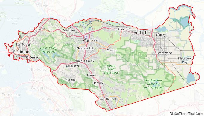
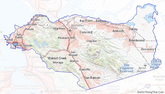
Contra Costa County Road Map
Geography
According to the U.S. Census Bureau, the county has a total area of 804 square miles (2,080 km), of which 716 square miles (1,850 km) is land and 88 square miles (230 km) (11%) is water.
Contra Costa County’s physical geography is dominated by the bayside alluvial plain, the Oakland Hills–Berkeley Hills, several inland valleys, and Mount Diablo, an isolated 3,849-foot (1,173 m) upthrust peak at the north end of the Diablo Range of hills. The summit of Mount Diablo is the origin of the Mount Diablo Meridian and Base Line, on which the surveys of much of California and western Nevada are based.
The Hayward Fault Zone runs through the western portion of the county, from Kensington to Richmond. The Calaveras Fault runs in the south-central portion of the county, from Alamo to San Ramon. The Concord Fault runs through part of Concord and Pacheco, and the Clayton-Marsh Creek-Greenville Fault runs from Clayton at its north end to near Livermore. These strike-slip faults and the Diablo thrust fault near Danville are all considered capable of significantly destructive earthquakes and many lesser related faults are present in the area that cross critical infrastructure such as water, natural gas, and petroleum product pipelines, roads, highways, railroads, and BART rail transit.
Sub-areas
Contra Costa County is broadly divided into three sub-areas:
- West County, including of the cities of El Cerrito, Richmond, San Pablo, Pinole, and Hercules, as well as the unincorporated communities of Kensington, El Sobrante, North Richmond, Rodeo, Crockett, and Port Costa.
- Central County, which is itself further divided into three areas:
- Lamorinda, including of the cities of Lafayette, Moraga, and Orinda (the name being a portmanteau of the three cities’ names), as well as the unincorporated area of Canyon.
- North Central County, including of the cities of Walnut Creek, Pleasant Hill, Concord, Clayton, and Martinez, as well as the unincorporated areas of areas of Pacheco, Vine Hill, Clyde, the Pleasant Hill BART station, and Saranap.
- San Ramon Valley, including the cities of Danville and San Ramon, and the unincorporated communities of Alamo, Blackhawk, and Tassajara.
- East County, including of the cities of Pittsburg, Antioch, Oakley, and Brentwood, as well as the unincorporated communities of Bay Point, Bethel Island, Knightsen, Discovery Bay, and Byron.
Adjacent counties
- Solano County – north
- Sacramento County – northeast
- San Joaquin County – east
- Alameda County – south
National protected areas
- Antioch Dunes National Wildlife Refuge
- Eugene O’Neill National Historic Site
- John Muir National Historic Site
- Port Chicago Naval Magazine National Memorial
- Rosie the Riveter/World War II Home Front National Historical Park
Mount Diablo
The most notable natural landmark in the county is the 3,849-foot (1,173 m) Mount Diablo, at the northerly end of the Diablo Range. Mount Diablo and its neighboring North Peak are the centerpiece of Mt. Diablo State Park (MDSP), created legislatively in 1921 and rededicated in 1931 after land acquisitions had been completed. At the time this park comprised a very small portion of the mountain.
In the 1960s, suburban development expanding from the surrounding valleys began to threaten the open space of the mountain. In 1971, MDSP consisted of 6,788 acres (27.5 km). That year, concerned residents formed the non-profit organization Save Mount Diablo to raise funds and awareness to protect more open space. In addition to encouraging acquisition by the state and local authorities, SMD started fundraising and acquiring properties to transfer to the park. MDSP was the first of twenty-nine Diablo-area parks and preserves that have been created around the peaks; today these preserves protect more than 89,000 acres (360 km).
These Diablo public lands stretch southeast and include the Concord Naval Weapons Station, Shell Ridge Open Space and Lime Ridge Open Spaces near Walnut Creek, to the State Park, and east to the Los Vaqueros Reservoir watershed and four surrounding East Bay Regional Park District preserves, including Morgan Territory Regional Preserve, Brushy Peak Regional Preserve, Vasco Caves Regional Preserve, and Round Valley Regional Preserve. The new Marsh Creek State Park, formerly known as Cowell Ranch State Park, and Black Diamond Mines Regional Preserve, are among the open spaces that stretch to the north. The open spaces controlled by cities, the East Bay Regional Park District, Mount Diablo State Park, and various regional preserves now adjoin and protect most of the elevated regions of the mountain.
The name Mount Diablo is said to originate from an incident involving Spanish soldiers who christened a thicket as Monte del Diablo when natives they were pursuing apparently disappeared into the thicket. Anglo settlers later misunderstood the use of the word ‘monte’ (which can mean ‘mountain’, or ‘thicket’), and applied the name to the most obvious local landmark.
According to the Contra Costa Times, in 2011, there were rumors that Contra Costa County was going to rename the mountain as “Mt. Ronald Reagan” or “Mt. Reagan”, after the former US President and California governor. Residents have generated multiple petitions to change the name of the mountain, one in 2005 and another in 2011, but these were not successful.
Contra Costa County Topographic Map
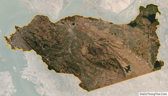
Contra Costa County Satellite Map
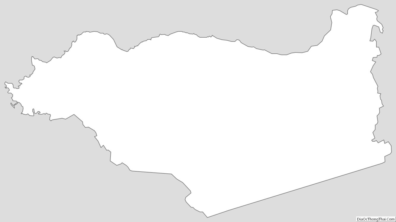
Contra Costa County Outline Map