Richmond is a city in western Contra Costa County, California, United States. The city was incorporated on August 7, 1905, and has a city council. Located in the San Francisco Bay Area’s East Bay region, Richmond borders San Pablo, Albany, El Cerrito and Pinole in addition to the unincorporated communities of North Richmond, Hasford Heights, Kensington, El Sobrante, Bayview-Montalvin Manor, Tara Hills, and East Richmond Heights, and for a short distance San Francisco on Red Rock Island in the San Francisco Bay. Richmond is one of two cities, the other being San Rafael, that sits on the shores of both San Francisco Bay and San Pablo Bay.
During Gayle McLaughlin’s mayoralty, Richmond was the nation’s largest city with a Green Party mayor. Its population was 116,448 as of the 2020 census.
| Name: | Richmond city |
|---|---|
| LSAD Code: | 25 |
| LSAD Description: | city (suffix) |
| State: | California |
| County: | Contra Costa County |
| Incorporated: | August 7, 1905 |
| Elevation: | 46 ft (14 m) |
| Land Area: | 30.05 sq mi (77.84 km²) |
| Water Area: | 22.46 sq mi (58.16 km²) 42.71% |
| Population Density: | 3,678.94/sq mi (1,420.43/km²) |
| ZIP code: | 94801, 94802, 94804, 94805, 94807, 94808, 94850 |
| Area code: | 510, 341 |
| FIPS code: | 0660620 |
| Website: | www.ci.richmond.ca.us |
Online Interactive Map
Click on ![]() to view map in "full screen" mode.
to view map in "full screen" mode.
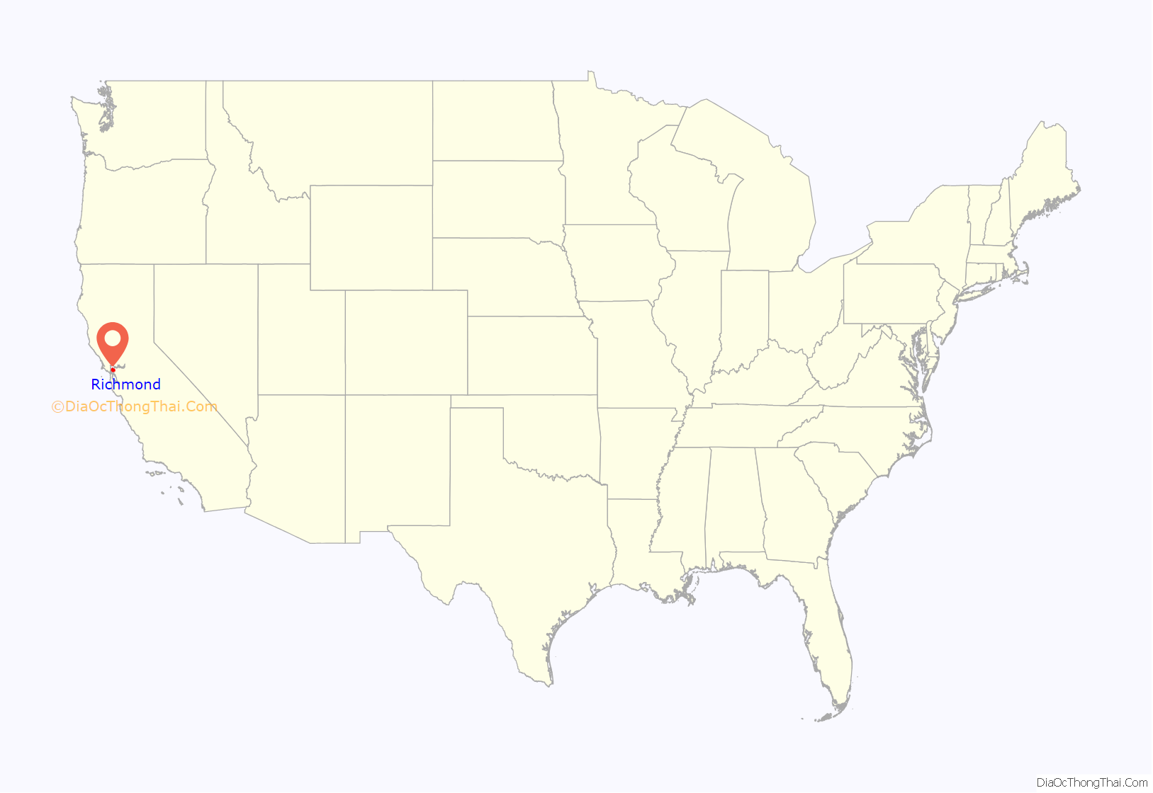
Richmond location map. Where is Richmond city?

History
The Ohlone were the first inhabitants of the Richmond-area, settling an estimated 5,000 years ago. They spoke the Chochenyo language, and subsisted as hunter-gatherers and harvesters.
Origins
The site that would eventually become the city of Richmond was part of the Rancho San Pablo land granted to Don Francisco María Castro, from which the nearby town of San Pablo inherited its name; the Point Richmond area was known originally as The Potrero and then renamed as Point Stevens in early charts of San Francisco Bay. Point Richmond was an island, but industrial development and deliberate fill connected it to the mainland by the early 1900s.
On July 4, 1900, the Santa Fe Railroad’s western terminus was established at Point Richmond with ferry connections from Ferry Point in the Brickyard Cove area to San Francisco. The Santa Fe railroad also built a major rail yard next to Point Richmond. It constructed a tunnel through the Potrero San Pablo ridge to run track from the yard to a ferry landing from which freight cars could be transshipped to San Francisco. Where this track crosses the main street in Point Richmond, there remain two of the last operational wigwag grade crossing signals in the United States, and the only surviving examples of the “upside-down” type. The wigwag is a type of railroad crossing signal that was phased out in the 1970s and ’80s across the country. There was controversy in 2005 when the State Transportation Authority ordered the BNSF railroad company to upgrade the railroad crossing signals. A compromise was achieved that included installing new modern crossing gates, red lights and bells while not removing, but simply shutting off, the historic ones and preserving their functionality for special events.
Standard Oil set up operations on land sold by Emily Tewksbury in 1901, including what is now the Chevron Richmond Refinery and tank farm, which Chevron still operates. There is a pier into San Francisco Bay south of Point Molate for oil tankers.
Early days
The city of Richmond was incorporated in 1905. Until the enactment of prohibition in 1919, the city had the largest winery in the world; the small abandoned village of Winehaven remains fenced off along Western Drive in the Point Molate Area. Richmond was a small town at that time, with some industrial development centered on the waterfront based around the railroad and oil refineries.
The Pullman Company also established a major facility in Richmond in the early 20th century. The facility connected with both the Santa Fe and Southern Pacific and serviced their passenger coach equipment. The Pullman Company was a large employer of African American men, who worked mainly as porters on the Pullman cars. Many of them settled in the East Bay, from Richmond to Oakland, before World War II.
From 1917 and throughout the 1920s, the Ku Klux Klan was active in the city.
In 1930 the Ford Motor Company opened the Richmond Assembly Plant, which later moved to Milpitas in 1956. The old Ford plant in Richmond has been listed on the National Register of Historic Places since 1988. In 2004 it was purchased by developer Eddie Orton, who converted it into an events center named Ford Point Building–The Craneway.
Wartime boomtown and shifting demographics
At the onset of World War II, the four Richmond Shipyards were built along Richmond’s waterfront, employing thousands of workers, many migrating to Richmond from other parts of the country after being recruited. These new workers generally lived in housing constructed specifically for the wartime boom, scattered throughout the San Francisco Bay Area, including Richmond, Berkeley and Albany. Many of these new migrants were Black Americans from the South and to a lesser extent the Midwest who took jobs in heavy industry and transport as those industries expanded to meet the needs of the war economy, while increased numbers of women also joined the industrial workforce for the first time as large numbers of working-age men were drafted for the war effort. During the war, Richmond’s population increased dramatically, rising from 23,000 in 1940 to 114,899 in 1942 and peaking at around 120,000 by 1945.
A specially built rail line, the Shipyard Railway, transported workers to the shipyards. Kaiser’s Richmond shipyards built 747 Victory and Liberty ships for the war effort, more than any other site in the U.S. The shipyards broke many records, including the completion of a Liberty ship in just five days. On average the yards built a new ship in 30 days.
The medical system established for the shipyard workers at the Richmond Field Hospital eventually became today’s Kaiser Permanente HMO. The hospital remained in operation until 1993, when it was replaced by the Richmond Medical Center hospital, which has since expanded to a multi-building campus.
Point Richmond was Richmond’s original commercial hub, but a new downtown arose in the center of the city along Macdonald Avenue during the war. It was populated by department stores such as Kress, J.C. Penney, Sears, Macy’s, and Woolworth’s.
An E&SR streetcar in the Macdonald Avenue subway in downtown Richmond, 1906
A 4,000-unit housing project was completed in Richmond during 1943.
USS General A. W. Greely, built in Richmond
Aerial photo of Richmond Shipyards, 1944, view directed north: #3 (west, foreground); #2 (rectangular basin, east foreground); #4 (end of the channel, south bank); #1 (north of the channel bend).
A “Wendy the Welder” at the Kaiser Richmond Shipyards, contributing to the war effort
Richmond Shipyards welders prepare for a performance demonstration test
Post-war decline and rebound
When the war ended the shipyard workers were no longer needed, and a decades-long population decline ensued. The census listed 99,545 residents in 1950. By 1960 much of the temporary housing built for the shipyard workers was torn down, and the population dropped to about 71,800.
Just before his April 1968 assassination, Martin Luther King Jr. had been working on plans for the Poor People’s Campaign, including a multi-city tour of the U.S. with a stop in Richmond. His son, Martin Luther King III, completed the Poverty in America Tour in 2007, stopping in Richmond. Unrest in late June 1968, sparked by the police shooting of a 15-year-old boy, damaged businesses in downtown along Macdonald Avenue. Most notably, the Travalini Furniture Store was destroyed by fire, which was assumed to be the result of the violent protests, but according to Fraser Felter, who was a reporter for the Richmond Independent, police sources told him the fire was set to avoid a debt instead by destroying store records.
In the 1970s, the Hilltop area was developed in Richmond’s northern suburbs, further depressing the downtown area as it drew retail clients and tenants away to the large indoor Hilltop Mall, which opened in 1976. The shopping mall, last named Hilltop Horizon, was opened under Taubman Centers, and has been sold since then to GM Pension Trust (1998), Simon Property Group (2007), Jones Lang LaSalle (2012), LBG Real Estate (2017), and Prologis (2021), who announced plans to close and demolish the building, reusing the land for a mixed-use development including residential, retail, and logistics facilities.
In the late 1990s the Richmond Parkway was built along Richmond’s western industrial and northwestern parkland, connecting Interstates 80 and 580. Construction of the Parkway, which follows the alignment of SR 93 as proposed in 1958, started in 1990 and completed in 1996 at a cost of $193 million. However, Caltrans issued a letter in 1998 saying it would not take over responsibility for the road unless it was brought up to expressway standards; as it was cost-prohibitive to convert it, the road remains the responsibility of the city and county.
In 2006, the city celebrated its centennial. This coincided with the repaving and streetscaping project of Macdonald Avenue. The city’s old rundown commercial district along Macdonald has been designated the city’s “Main Street District” by the state of California. This has led to funding of improvements in the form of state grants.
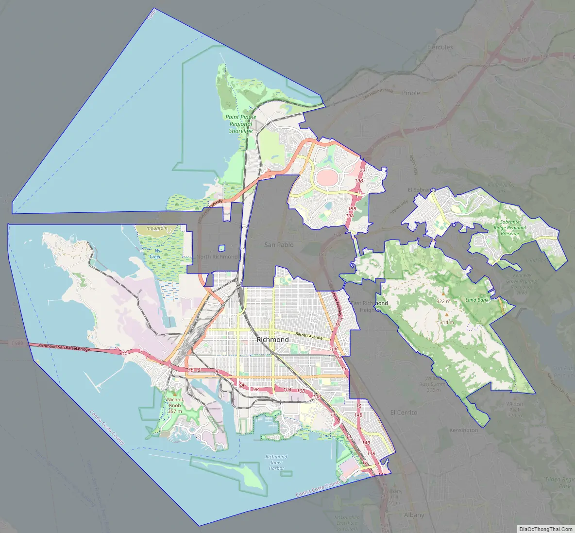
Richmond Road Map
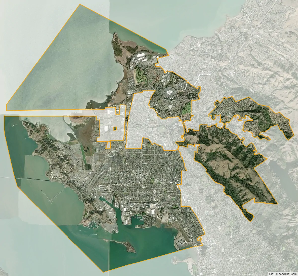
Richmond city Satellite Map
Geography
Richmond is located at 37°56′09″N 122°20′52″W / 37.93583°N 122.34778°W / 37.93583; -122.34778. According to the United States Census Bureau, the city has a total area of 52.5 square miles (136 km), of which 30.1 square miles (78 km) is land and 22.4 square miles (58 km) (comprising 42.71%) is water. The city sits on 32 miles (51 km) of waterfront, more than any other city in the Bay Area. The city borders San Francisco Bay to the southwest and San Pablo Bay to the northwest, and includes Brooks Island and the Brother Islands entirely, and half of Red Rock Island.
There are several cities and unincorporated communities surrounding or bordering Richmond. To the south is the city of Albany which is in Alameda County and the city of El Cerrito. The unincorporated communities of East Richmond Heights, Rollingwood, Hasford Heights, and El Sobrante lie to the east. North Richmond to the west and San Pablo to the east are almost entirely surrounded by Richmond’s city limits. To the north, Richmond borders the city of Pinole and the unincorporated areas of Bayview, Montalvin Manor, Hilltop Green, Tara Hills. Richmond borders Alameda, San Francisco, and Marin counties in the Bay and Red Rock Island.
The city is within the 94801, 94803, 94804, 94805, and 94806 ZIP Codes.
Climate
Richmond, like much of the coastal East Bay, enjoys a very mild Mediterranean climate year round. The climate is slightly warmer than the coastal areas of San Francisco, the Peninsula, and Marin County; it is however more temperate than areas further inland. The average highs range from 57 to 73 °F (14 to 23 °C) and the lows range from 43 to 56 °F (6 to 13 °C) year round. Richmond usually enjoys an “Indian summer”, and September is, on average, the warmest month. January is on average the coldest month.
The highest recorded temperature in Richmond was 107 °F (42 °C) in September 1971 while the coldest was 24 °F (−4 °C) in December 1990.
The rainy season begins in late October and ends in April, with some showers in May. Most of the rain occurs during stronger storms which occur between November and March and drop 3.3–4.91 inches (84–125 mm) of rain per month. January and February are the rainiest months.
Like most of the Bay Area, Richmond is made up of several microclimates. Southern parts of the city and the ridges receive more fog than northern areas. Summer temperatures are higher in inland areas, where the moderating influence of San Francisco Bay is lessened. The average wind speed is 6–9 miles per hour (10–14 km/h) with stronger winds from March through August; the strongest winds are in June. The city also enjoys more than 80% sunshine seven months out of the year and ten months with 60% or more. December and January are the darkest months with about 45% average brightness. The city experiences virtually no snowfall, and brief hail annually.
See also
Map of California State and its subdivision:- Alameda
- Alpine
- Amador
- Butte
- Calaveras
- Colusa
- Contra Costa
- Del Norte
- El Dorado
- Fresno
- Glenn
- Humboldt
- Imperial
- Inyo
- Kern
- Kings
- Lake
- Lassen
- Los Angeles
- Madera
- Marin
- Mariposa
- Mendocino
- Merced
- Modoc
- Mono
- Monterey
- Napa
- Nevada
- Orange
- Placer
- Plumas
- Riverside
- Sacramento
- San Benito
- San Bernardino
- San Diego
- San Francisco
- San Joaquin
- San Luis Obispo
- San Mateo
- Santa Barbara
- Santa Clara
- Santa Cruz
- Shasta
- Sierra
- Siskiyou
- Solano
- Sonoma
- Stanislaus
- Sutter
- Tehama
- Trinity
- Tulare
- Tuolumne
- Ventura
- Yolo
- Yuba
- Alabama
- Alaska
- Arizona
- Arkansas
- California
- Colorado
- Connecticut
- Delaware
- District of Columbia
- Florida
- Georgia
- Hawaii
- Idaho
- Illinois
- Indiana
- Iowa
- Kansas
- Kentucky
- Louisiana
- Maine
- Maryland
- Massachusetts
- Michigan
- Minnesota
- Mississippi
- Missouri
- Montana
- Nebraska
- Nevada
- New Hampshire
- New Jersey
- New Mexico
- New York
- North Carolina
- North Dakota
- Ohio
- Oklahoma
- Oregon
- Pennsylvania
- Rhode Island
- South Carolina
- South Dakota
- Tennessee
- Texas
- Utah
- Vermont
- Virginia
- Washington
- West Virginia
- Wisconsin
- Wyoming


