Pittsburg is a city in Contra Costa County, California, United States. It is an industrial suburb located on the southern shore of the Suisun Bay in the East Bay region of the San Francisco Bay Area, and is part of the Sacramento–San Joaquin River Delta area, the Eastern Contra Costa County area, and the San Francisco Bay Area. The population was 76,416 at the 2020 United States Census.
| Name: | Pittsburg city |
|---|---|
| LSAD Code: | 25 |
| LSAD Description: | city (suffix) |
| State: | California |
| County: | Contra Costa County |
| Incorporated: | June 25, 1903 |
| Elevation: | 26 ft (8 m) |
| Total Area: | 19.71 sq mi (51.05 km²) |
| Land Area: | 17.64 sq mi (45.69 km²) |
| Water Area: | 2.07 sq mi (5.36 km²) 10.11% |
| Total Population: | 76,416 |
| Population Density: | 4,332/sq mi (1,672.5/km²) |
| ZIP code: | 94565 |
| Area code: | 925 |
| FIPS code: | 0657456 |
| Website: | www.ci.pittsburg.ca.us |
Online Interactive Map
Click on ![]() to view map in "full screen" mode.
to view map in "full screen" mode.
Pittsburg location map. Where is Pittsburg city?


History
Originally settled in 1839 as “Rancho Los Medanos”, the area of almost 10,000 acres was issued to Californios Jose Antonio Mesa and his brother Jose Miguel under a Mexican Land Grant by then Governor Juan Bautista Alvarado, one of the final land grants issued prior to the formation of California as a state.
In 1849, during the California Gold Rush, Colonel Jonathan D. Stevenson (from New York) bought the Rancho Los Medanos land grant for speculation, and laid out a town he called New York of the Pacific. General William Tecumseh Sherman laid out the first network of streets on the west side of town. The area was the midway stopping point for schooners traveling from San Francisco to the gold country further inland. Fishing, farming, and cattle raising for the hide and tallow industry were the major economic activities during this time.
In 1859, with the discovery of coal in the nearby town of Nortonville, the place became a port for coal. The Black Diamond Coal Mining Company commenced operations, building the Black Diamond Coal Mining Railroad to Nortonville. Steam powered engines moved coal cars down the tracks along present day Railroad Avenue to the waterfront docks that came to be called “Black Diamond Landing.” The boom ended in 1885, and the company moved to Washington state to work a new claim.
In the 1870s, commercial fishing took hold and the Black Diamond Cannery was established at the foot of Los Medanos St. By 1882, a network of ten canneries was formed along the Sacramento Delta. An industry was born with fishermen, packing plants, boat builders and the like dominating the local waterfront for the next 80 years. The town boasted the largest Delta fishing community in the state, made up primarily of Sicilian immigrants, the families of which have remained in the area for generations. In 1957, the State of California closed down the Sacramento Delta to commercial fishing, ending the area’s industry.
In 1900, C.A. Hooper purchased the land grant and gave birth to many manufacturing ventures, beginning in 1903 with the creation of the Industrial Center of the West. Hooper secured additional capitalization and provided property for the Columbia Steel Company, which, in 1910, opened its California steel plant in Pittsburg with one foundry and a crew of 60 employees. It made steel castings for the dredging, lumber and shipping industries.
In 1903 the town was incorporated, and by a vote of the citizenry, was renamed “Black Diamond”, after the mining firm. Because of the industrial potential of the site, a name change to Pittsburg was proposed in 1909. On February 11, 1911, the city officials changed the town’s name to “Pittsburg”, honoring Pittsburgh, Pennsylvania, as the two cities shared a common steel and mining industrial heritage. This rechristening came at a time when the name of Pittsburgh, Pennsylvania was more commonly spelled without the “h”. In 1918 the shipyard of the Pacific Coast Shipbuilding Company was built in neighboring Bay Point, the associated company town of Clyde, California alongside it, but as soon as the World War I shipbuilding boom was over, the yard was closed in 1921.
In 1930, Columbia Steel became a subsidiary of U.S. Steel. At that point the company had expanded into Utah and was worth $40,000,000. The Pittsburg plant continued to grow until the early 1950s, reaching a peak staff of 5,200 employees when the markets for its products crashed. The parent company (by 1986, renamed as USS Company) had merged with Korean Pohang Iron and Steel Company. Together they invested $450 million turning the Pittsburg plant into a modern flat-products mill, renamed as USS-Posco. As of 1999, the facility employed 970 workers and shipped over 1.6 million U.S. tons per year of steel to over 175 customers in the Western U. S., Mexico, Canada and the Pacific Rim.
The original town site fronts on the Sacramento/San Joaquin River Delta, reflecting its origins as a deep water channel river port. (As of January 1, 2007, state legislation [Assembly Bill 2324] enabled the city to manage its own riverfront for commercial development and subsequent port operations). Since the early 1900s, the city has grown inland to the south, then spread east and west along State Route 4, now a freeway carrying resident commuters to jobs in the San Francisco Bay-Oakland Region. In the process, the former town of Cornwall, California was absorbed. As of the 2000 census, the city had a total population of 56,769.
Camp Stoneman was built in 1942, and was a major staging area for the United States Army during World War II and the Korean War until 1954.
The post office first opened in 1868 as Black Diamond, and changed its name with the town’s in 1911.
Pittsburg Road Map

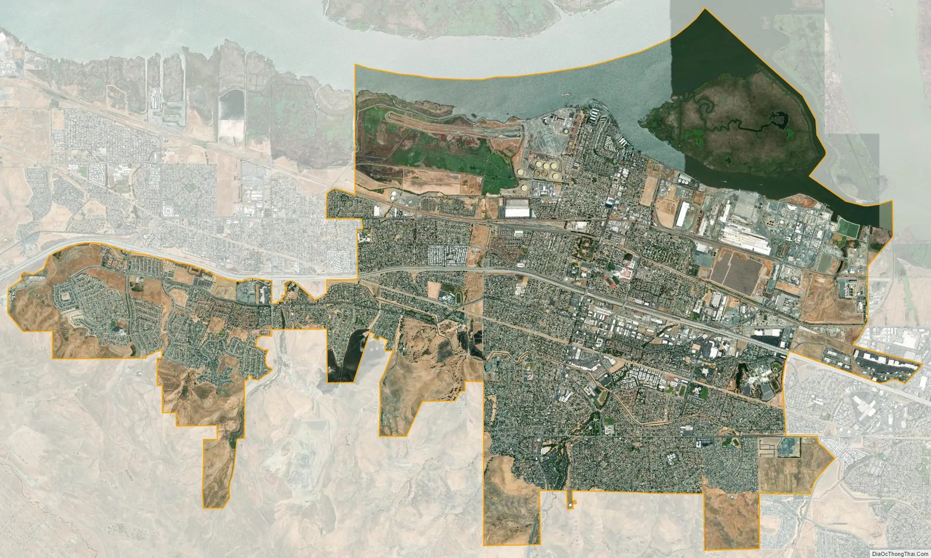
Pittsburg city Satellite Map
Geography
The city of Pittsburg is located 37 miles northeast from San Francisco, 29 miles northeast from Oakland, California, 60 miles north of San Jose and 65 miles south of Sacramento, California. Pittsburg shares a border with the unincorporated community of Bay Point, California to the west, the city of Concord, California to the southwest and Antioch, California to the east. The Suisun Bay is directly north of the city and connects the San Francisco Bay to the Sacramento and San Joaquin rivers.
Climate
Pittsburg experiences a hot summer Mediterranean climate (Köppen climate classification Csa) bordering on the Semi-arid climate because of the Mt. Diablo rain shadow in East Contra Costa County.
See also
Map of California State and its subdivision:- Alameda
- Alpine
- Amador
- Butte
- Calaveras
- Colusa
- Contra Costa
- Del Norte
- El Dorado
- Fresno
- Glenn
- Humboldt
- Imperial
- Inyo
- Kern
- Kings
- Lake
- Lassen
- Los Angeles
- Madera
- Marin
- Mariposa
- Mendocino
- Merced
- Modoc
- Mono
- Monterey
- Napa
- Nevada
- Orange
- Placer
- Plumas
- Riverside
- Sacramento
- San Benito
- San Bernardino
- San Diego
- San Francisco
- San Joaquin
- San Luis Obispo
- San Mateo
- Santa Barbara
- Santa Clara
- Santa Cruz
- Shasta
- Sierra
- Siskiyou
- Solano
- Sonoma
- Stanislaus
- Sutter
- Tehama
- Trinity
- Tulare
- Tuolumne
- Ventura
- Yolo
- Yuba
- Alabama
- Alaska
- Arizona
- Arkansas
- California
- Colorado
- Connecticut
- Delaware
- District of Columbia
- Florida
- Georgia
- Hawaii
- Idaho
- Illinois
- Indiana
- Iowa
- Kansas
- Kentucky
- Louisiana
- Maine
- Maryland
- Massachusetts
- Michigan
- Minnesota
- Mississippi
- Missouri
- Montana
- Nebraska
- Nevada
- New Hampshire
- New Jersey
- New Mexico
- New York
- North Carolina
- North Dakota
- Ohio
- Oklahoma
- Oregon
- Pennsylvania
- Rhode Island
- South Carolina
- South Dakota
- Tennessee
- Texas
- Utah
- Vermont
- Virginia
- Washington
- West Virginia
- Wisconsin
- Wyoming


