Southport is a census-designated place (CDP) in the town of Fairfield, Connecticut. It is located along Long Island Sound between Mill River and Sasco Brook, where it borders Westport. As of the 2020 census, it had a population of 1,710. Settled in 1639, Southport center has been designated a local historic district since 1967. In 1971, it was listed on the National Register of Historic Places as the Southport Historic District.
| Name: | Southport CDP |
|---|---|
| LSAD Code: | 57 |
| LSAD Description: | CDP (suffix) |
| State: | Connecticut |
| County: | Fairfield County |
| Total Area: | 0.992 sq mi (2.57 km²) |
| Land Area: | 0.858 sq mi (2.22 km²) |
| Water Area: | 0.134 sq mi (0.35 km²) |
| Total Population: | 1,710. |
| ZIP code: | 06890 |
| Area code: | 203/475 |
| FIPS code: | 0971040 |
| GNISfeature ID: | 2631576 |
Online Interactive Map
Click on ![]() to view map in "full screen" mode.
to view map in "full screen" mode.
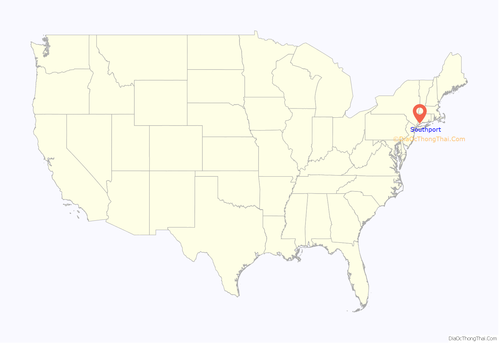
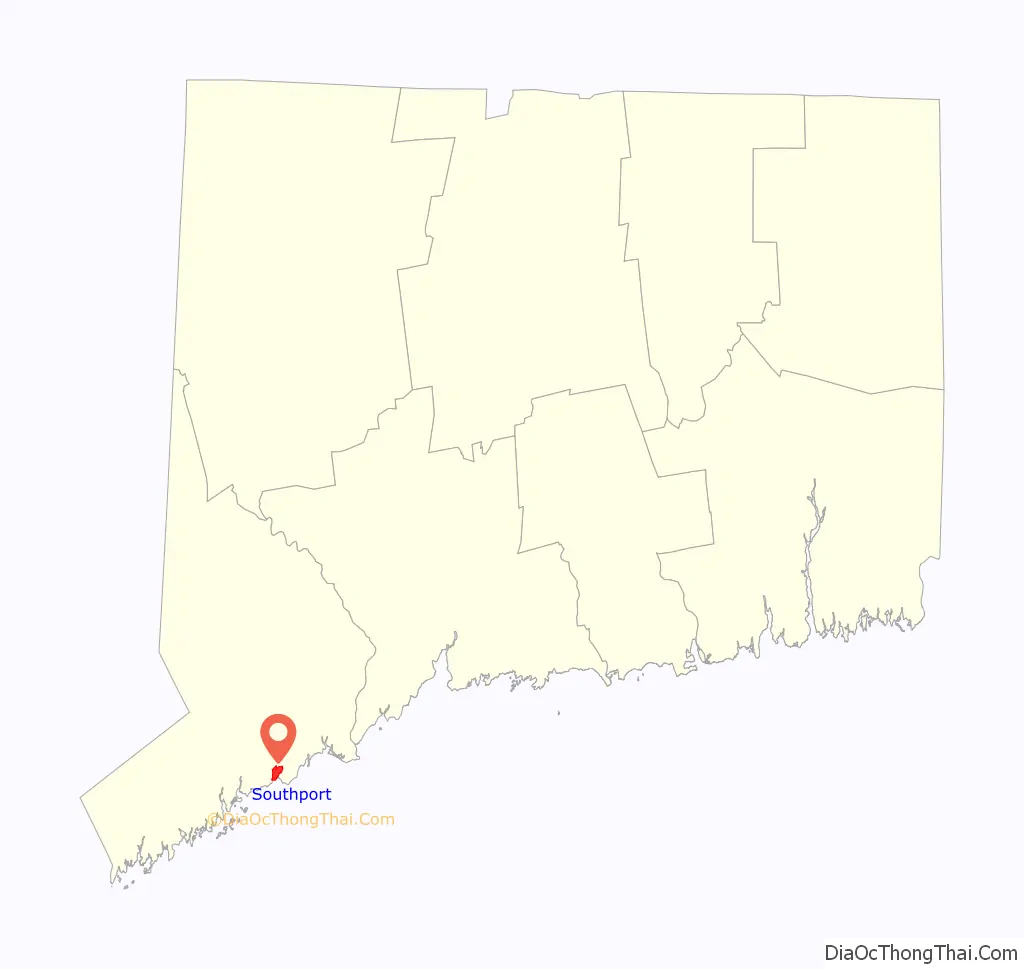
Southport location map. Where is Southport CDP?
History
The indigenous village of Sasqua, inhabited by Quiripi language speakers, was located in the area. Members of that community later formed the Golden Hill Paugussett Indian Nation.
The earliest recorded event in Southport’s history was “The Great Swamp Fight” or “Fairfield Swamp Fight” of July 1637 (not to be confused with the later Great Swamp Fight of King Philip’s War), an episode of the Pequot War in which English colonial forces led by John Mason and Roger Ludlow vanquished a band of 80 to 100 Pequot Indians who had earlier fled from their home territory in the Mystic area and taken refuge with approximately 200 Sasqua Indians who inhabited the area that is now Fairfield. The exact location of the battle is unclear, but it is known to have been in the vicinity of Southport. In 1639, Ludlow established the town of Fairfield on the Pequot land known as Unquowa. Colonial deeds of land were signed with the Sasqua in the 1670s.
In the eighteenth century, Mill River village, a part of Fairfield, was a small hamlet of a few houses and a wharf at the mouth of Fairfield’s Mill River. Farm products from the surrounding area were shipped from Mill River’s small harbor to ports in New York and beyond.
By 1831 the village had changed its name to Southport and was a bustling commercial area with warehouses, churches, schools, stores and elegant houses. Before 1853, Southport had its own local government as a borough within the town of Fairfield.
Economic history
Southport became a leading coastal port on Long Island Sound, its ships carrying produce and goods back and forth to New York City. A measure of Southport’s success is the fact that throughout the 1800s it possessed the only two banks in town. However, competition from steamboats and the railroad took its toll on prosperity. Resourceful shippers teamed with local farmers and businessmen to keep the port going.
The Southport Onion, a high quality onion, was developed and grown on Westport’s and Fairfield’s hills and shipped in Southport market boats. These boats were mostly sloops that carried 50 tons and more in some cases of cargo keeping the harbor profitable until the end of the century. The federal government supported repairs to the harbor in the 1840s. During the 1840s the greatest agricultural innovation in Fairfield became the cultivation of onions. From 1840 to 1890, 200,000 tons yearly were shipped out of Southport. Designed to be easily stored, during The Civil War sales spiked, its high vitamin C content prized by the U.S. Navy to prevent scurvy. The U.S. Army prized it to treat gunshot wounds, at one point to the extent that General Ulysses S. Grant refused to move his troops if they were not supplied with onions.
In the 1890s, 100,000 barrels of locally grown onions, carrots, potatoes, and other goods were shipped annually from Southport harbor.
The shipping industry was the economic foundation of the village of Mill River. The village, as it became a large port, eventually changed its name to South Port, later Southport. Local farmers transported their Southport Globe onions and other crops via the growing shipping fleet housed in the harbor and, by 1836, it became larger than the New York City and Boston ports. The ships sailed to destinations as far as the West Indies, but often went to New York City, where larger vessels in a deeper port headed to more distant foreign destinations. During the 150 years between 1750 and 1900, the shipping industry grew dramatically, but died out as the railroad industry and steamship industries took over. The increased use of large shipping containers also decreased transport costs and eventually drove the need to use ports deeper than Southport Harbor. The local produce was transported to New York and Boston via train, to deeper water ports where larger vessels were docked.
Local Sea Captains
During the peak of the shipping era, Southport had four shipyards in old Mill River, and many of Southport’s first families built their wealth in the lucrative shipping trade that grew in response to local farmers wanting a more convenient port than Bridgeport and Norwalk Harbors. Numerous area parks and streets are named after prominent sea captains, including Bulkley Avenue, Sherwood Island State Park, and Sturges Highway. Capt. Zalman Wakeman owned Wakeman Farms, which is still operating today.
Preservation
Today, much of the old village area is part of a town historic district, first established in 1967, where buildings from three centuries are protected for future generations. The boundaries of the town historic district are the railroad on the north; the Mill River and Southport Harbor on the south; Church Street; and Old South Road and Rose Hill Road on the west and east, respectively, including all properties on both sides of the roads. Strict historic zoning regulations apply in the district and have been upheld by the Connecticut Supreme Court. The Southport Historic District is also listed on the National Register of Historic Places.
Southport Road Map
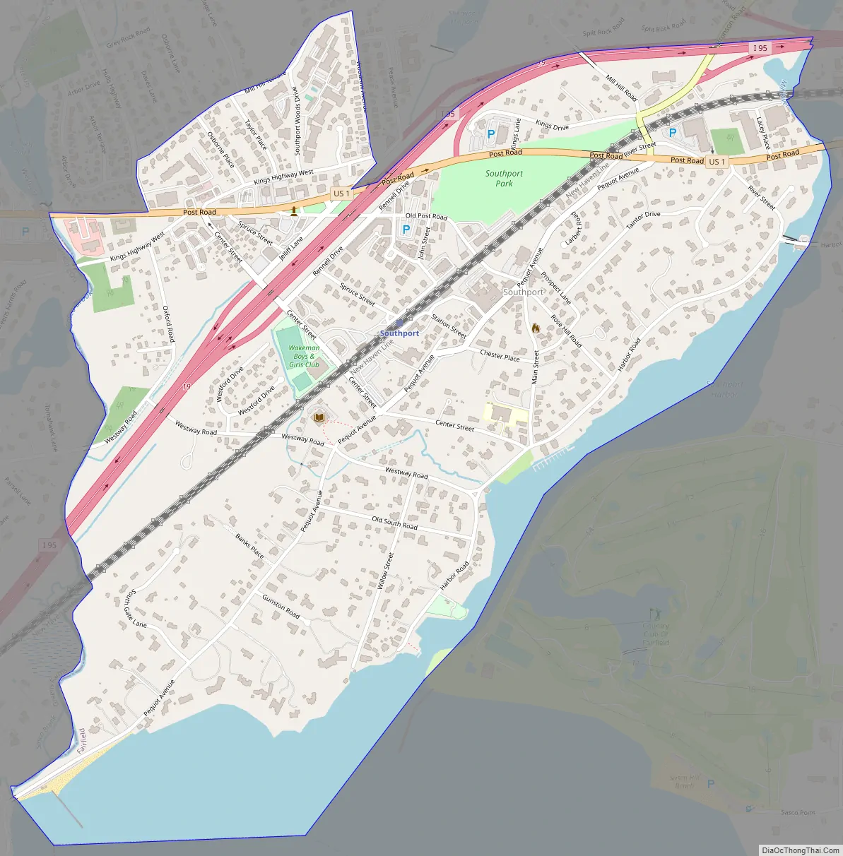
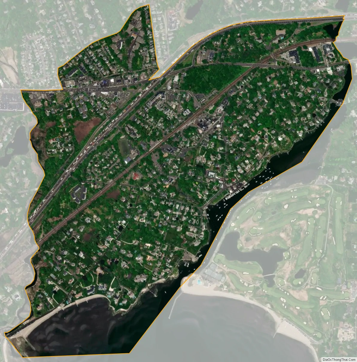
Southport city Satellite Map
Geography
According to the United States Census Bureau, Southport has a total area of 1.338 square miles (3.47 km), of which 1.191 square miles (3.08 km) is land and 0.147 square miles (0.38 km), or 10.99%, is water.
See also
Map of Connecticut State and its subdivision: Map of other states:- Alabama
- Alaska
- Arizona
- Arkansas
- California
- Colorado
- Connecticut
- Delaware
- District of Columbia
- Florida
- Georgia
- Hawaii
- Idaho
- Illinois
- Indiana
- Iowa
- Kansas
- Kentucky
- Louisiana
- Maine
- Maryland
- Massachusetts
- Michigan
- Minnesota
- Mississippi
- Missouri
- Montana
- Nebraska
- Nevada
- New Hampshire
- New Jersey
- New Mexico
- New York
- North Carolina
- North Dakota
- Ohio
- Oklahoma
- Oregon
- Pennsylvania
- Rhode Island
- South Carolina
- South Dakota
- Tennessee
- Texas
- Utah
- Vermont
- Virginia
- Washington
- West Virginia
- Wisconsin
- Wyoming