Salem (/ˈseɪləm/ SAY-ləm) is a historic coastal city in Essex County, Massachusetts, United States, located on the North Shore of Greater Boston. Continuous settlement by Europeans began in 1626 with English colonists. Salem would become one of the most significant seaports trading commodities in early American history. It is a suburb of Boston.
Today Salem is a residential and tourist area that is home to the House of Seven Gables, Salem State University, Pioneer Village, the Salem Maritime National Historic Site, Salem Willows Park, and the Peabody Essex Museum. It features historic residential neighborhoods in the Federal Street District and the Charter Street Historic District. The city’s population was 44,480 at the 2020 census.
Salem is widely noted for the infamous Salem witch trials of 1692. Some of Salem’s police cars are adorned with witch logos, a public elementary school is known as Witchcraft Heights, and the Salem High School athletic teams are named the Witches. Gallows Hill is believed to have once been the site of many public hangings, including of persons convicted as witches. It is now a park and used as a playing field for various sports.
| Name: | Salem city |
|---|---|
| LSAD Code: | 25 |
| LSAD Description: | city (suffix) |
| State: | Massachusetts |
| County: | Essex County |
| Incorporated: | 1629 |
| Elevation: | 26 ft (8 m) |
| Total Area: | 18.30 sq mi (47.40 km²) |
| Land Area: | 8.29 sq mi (21.48 km²) |
| Water Area: | 10.01 sq mi (25.92 km²) |
| Total Population: | 44,480 |
| Population Density: | 5,362.91/sq mi (2,070.66/km²) |
| ZIP code: | 01970 |
| Area code: | 351, 978 |
| FIPS code: | 2559105 |
| Website: | www.salem.com |
Online Interactive Map
Click on ![]() to view map in "full screen" mode.
to view map in "full screen" mode.
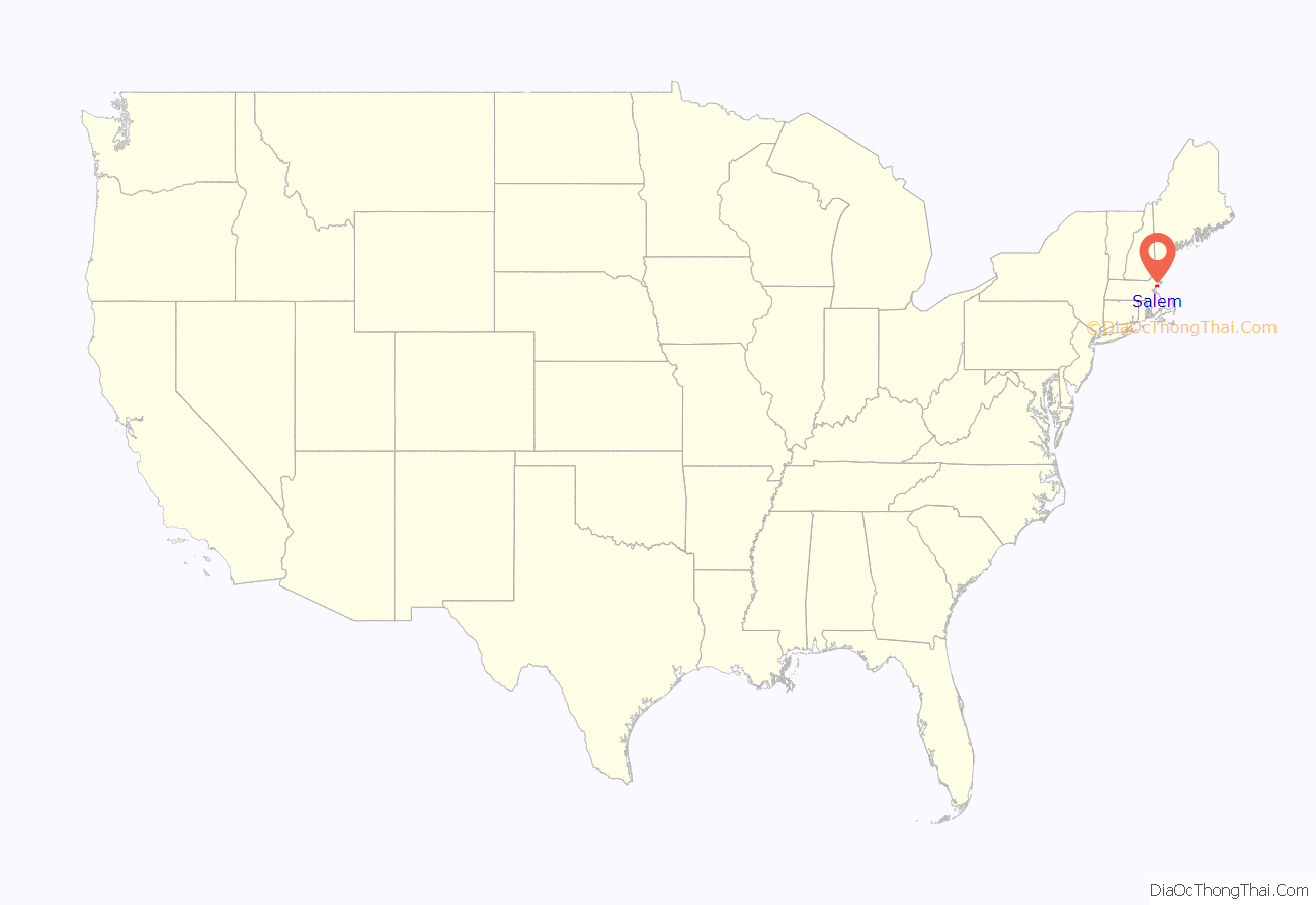
Salem location map. Where is Salem city?
History
Naumkeag
Native Americans lived in northeastern Massachusetts for thousands of years prior to European colonization of the Americas. The peninsula that would become Salem was known as Naumkeag (alternate spellings Naemkeck, Nahumkek, Neumkeage) by the native people who lived there at the time of contact in the early 1600s. Naumkeag was a major settlement for the indigenous group that controlled territory from the Merrimack to the Mystic rivers. The English and other Europeans referred to them as the Naumkeag people. There are probable indigenous settlement sites near the mouths of the North, South, and Forest rivers in Salem.
The contact period was a disastrous time for the Naumkeag. Many Naumkeag died in a war with the Tarrantine and as a result of a smallpox epidemic in 1617–1619, including their powerful sachem Nanepashemet. The disease had probably been contracted by members who came into contact with European fishermen or explorers. Their strength was reduced just prior to the arrival of English settlers in 1626 to what became modern-day Salem. In 1633, a second smallpox epidemic struck, killing two of Nanepashemet’s successors, Montowompate and Wonohaquaham, and leaving his remaining heir Wenepoykin scarred. So it was that English settlers met little resistance on their arrival in Salem. Although Wenepoykin would join Metacomet in King Philip’s War in 1675, the English settlers at this point had the numerical superiority to defeat Metacomet’s indigenous coalition.
It was not until 1686, when the Massachusetts Bay Colony Charter was recalled by the King in the creation of the Dominion of New England that Wenepoykin’s heirs pressed their claim to the land of Salem, for which they were paid twenty pounds.
English colonization
Colonists settled Naumkeag in 1626 when a company of fishermen arrived from Cape Ann led by Roger Conant. Conant’s leadership provided the stability for the settlers to survive the first two years, but John Endecott replaced him by order of the Massachusetts Bay Company. Conant stepped aside and was granted 200 acres (0.81 km) of land in compensation. These “New Planters” and the “Old Planters” agreed to cooperate because of the diplomacy of Conant and Endecott. To recognize this peaceful transition to the new government, the name of the settlement was changed to Salem, the hellenized name of Shalem (שָׁלֵם), the royal city of Melchizedek, which is identified with Jerusalem.
In 1628, Endecott ordered that the Great House be moved from Cape Ann, reassembling it on Washington Street north of Church Street. Francis Higginson wrote that “we found a faire house newly built for the Governor” which was remarkable for being two stories high. A year later, the Massachusetts Bay Charter was issued creating the Massachusetts Bay Colony with Matthew Craddock as its governor in London and Endecott as its governor in the colony. John Winthrop was elected Governor in late 1629, and arrived with the Winthrop Fleet in 1630, one of the many events that began the Puritan Great Migration.
In 1639, Endecott, among others, signed the building contract for enlarging the meeting house in Town House Square for the first church in Salem. This document remains part of the town records at City Hall. He was active in the affairs of the town throughout his life. Samuel Skelton was the first pastor of the First Church of Salem, which is the original Puritan church in America. Endecott already had a close relationship with Skelton, having been converted by him, and Endecott considered him as his spiritual father.
Salem’s harbor was defended by Fort Miller in Marblehead from 1632 to 1865, and by Fort Pickering on Winter Island from 1643 to 1865. During the 17th and 18th centuries, Salem was involved in the Atlantic slave trade, surpassing Boston in terms of the town’s engagement with the triangular trade. Beginning in 1701 there was a steady political and social effort in Massachusetts to end slavery and by 1770 the practice was all but eliminated, with many slaves winning their freedom.
In 1768, Samuel Hall established Salem’s first print shop and founded The Essex Gazette Salem’s first newspaper, and the third to emerge in Massachusetts.
Witchcraft Trials
One of the most widely known aspects of Salem is its history of witchcraft allegations, which started with Abigail Williams, Betty Parris, and their friends playing “with a Venus glase & an Egg” to learn “what trade their sweet harts should be of.” The infamous Salem Witch Trials began in 1692, and 19 people were executed by hanging because of the false accusations; Giles Corey was pressed to death for refusing to plead innocent or guilty, thus avoiding the noose and instead dying an innocent man. Salem is also significant in legal history as the site of the Dorothy Talbye Trial, where a mentally ill woman was hanged for murdering her daughter because Massachusetts made no distinction at the time between insanity and criminal behavior.
William Hathorne was a prosperous entrepreneur in early Salem and became one of its leading citizens. He led troops to victory in King Philip’s War, served as a magistrate on the highest court, and was chosen as the first speaker of the House of Deputies. He was a zealous advocate of the personal rights of freemen against royal emissaries and agents. His son Judge John Hathorne came to prominence in the late 17th century when witchcraft was a serious felony. Judge Hathorne is the best known of the witch trial judges, and he became known as the “Hanging Judge” for sentencing accused witches to death.
American Revolution
On February 26, 1775, patriots raised the drawbridge at the North River on North Street, preventing British Colonel Alexander Leslie and his 300 troops of the 64th Regiment of Foot from seizing stores and ammunition hidden in North Salem. Both parties came to an agreement and no blood was shed that day, but war broke out at Lexington and Concord soon after. A group of prominent merchants with ties to Salem published a statement retracting what some interpreted as Loyalist leanings and professing their dedication to the American cause, including Francis Cabot, William Pynchon, Thomas Barnard, E. A. Holyoke, and William Pickman.
During the American Revolutionary War, the town became a center for privateering. The documentation is incomplete, but about 1,700 Letters of Marque were granted during that time, issued on a per-voyage basis. Nearly 800 vessels were commissioned as privateers and are credited with capturing or destroying about 600 British ships. Privateering resumed during the War of 1812.
Trade with the Pacific and Africa
Following the American Revolution, many ships used as privateers were too large for short voyages in the coasting trade, and their owners determined to open new avenues of trade to distant countries. The young men of the town, fresh from service on the armed ships of Salem, were eager to embark in such ventures. Captain Nathaniel Silsbee, his first mate Charles Derby, and second mate Richard J. Cleveland were not yet twenty years old when they set sail on a nineteen-month voyage that was perhaps the first from the newly independent America to the East Indies. In 1795, Captain Jonathan Carnes set sail for Sumatra in the Malay Archipelago on his secret voyage for pepper. Nothing was heard from him until eighteen months later, when he entered Salem harbor with a cargo of pepper in bulk, the first to be so imported into the country, and which sold at the extraordinary profit of seven hundred per cent. The Empress of China, formerly a privateer, was refitted as the first American ship to sail from New York to China.
By 1790, Salem had become the sixth-largest city in the country, and a world-famous seaport—particularly in the China Trade. It had a large cod fishing industry, conducted off the Newfoundland Banks. It exported codfish to Europe and the West Indies, imported sugar and molasses from the West Indies, tea from China, and products depicted on the city seal from the East Indies—in particular Sumatran pepper. Salem ships also visited Africa in the slave trade—Zanzibar in particular. They also traveled to Russia, Japan, and Australia.
The sail frigate USS Essex was built at one of Enos Briggs’s shipyards on Winter Island in 1799.
The neutrality of the United States was tested during the Napoleonic Wars. After the Chesapeake–Leopard affair, Congress passed the Embargo Act of 1807. President Thomas Jefferson closed all ports, an economic blow to the seaport town of Salem. The embargo was the starting point on the path to the War of 1812. Both the United Kingdom and France imposed trade restrictions to weaken each other’s economies. This disrupted American trade and tested the United States’ neutrality. Royal Navy ships frequently interdicted U.S. merchant ships trading with France and seized their goods, and at times would impress American sailors.
The Federal period (1788–1845) marks the beginning of U.S. international relations. Salem had established trade relations with merchants in distant lands, which were a source of livelihood and prosperity for many. Charles Endicott, master of Salem merchantman Friendship, returned in 1831 to report Sumatran natives had plundered his ship, murdering the first officer and two crewmen. Following public outcry, President Andrew Jackson ordered the Potomac on the First Sumatran Expedition, which departed New York City on August 19, 1831.
In another direction, diplomat Edmund Roberts negotiated a treaty with Said bin Sultan, Sultan of Muscat and Oman on September 21, 1833. In 1837, the sultan moved his main place of residence to Zanzibar and welcomed Richard Waters, a resident of Salem, as a United States consul of the early years.
Legacy of the East Indies and Old China Trade
The Old China Trade left a significant mark in two historic districts, Chestnut Street District, part of the Samuel McIntire Historic District containing 407 buildings, and the Salem Maritime National Historic Site, comprising 12 historic structures and about 9 acres (36,000 m) of land along the waterfront in Salem. Elias Hasket Derby was among the wealthiest and most celebrated of post-Revolutionary merchants in Salem. Derby was also the owner of the Grand Turk, the first New England vessel to trade with China and the second, after the Empress of China, to sail from the United States. Thomas H. Perkins was his supercargo and established strong ties with the Chinese and garnered the Forbes fortune through his illegal opium sales.
Salem was incorporated as a city on March 23, 1836, and adopted a city seal in 1839 with the motto “Divitis Indiae usque ad ultimum sinum“, Latin for “To the rich East Indies until the last lap.” Nathaniel Hawthorne was overseer of Salem’s port from 1846 until 1849. He worked in the U.S. Custom House across the street from the port near Pickering Wharf, his setting for the beginning of The Scarlet Letter. In 1858, an amusement park was established at Juniper Point, a peninsula jutting into the harbor. Prosperity left the city with a wealth of fine architecture, including Federal-style mansions designed by one of America’s first architects, Samuel McIntire, for whom the city’s largest historic district is named. These homes and mansions now make up the greatest concentrations of notable pre-1900 domestic structures in the United States.
Shipping declined throughout the 19th century. Boston and New York City eclipsed Salem and its silting harbor. Consequently, the city turned to manufacturing. Industries included tanneries, shoe factories, and the Naumkeag Steam Cotton Company. The Great Salem Fire of 1914 destroyed over 400 homes and left 3,500 families homeless but spared the historic concentration of Federal architecture on Chestnut Street. A memorial plaque on a drugstore building marks the former site of the Korn Leather Factory, which burned in the fire.
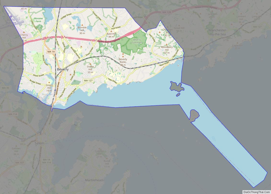
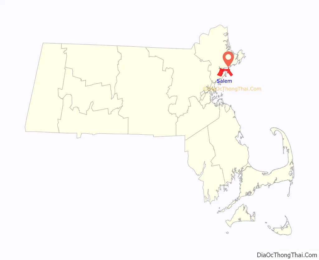
Salem Road Map
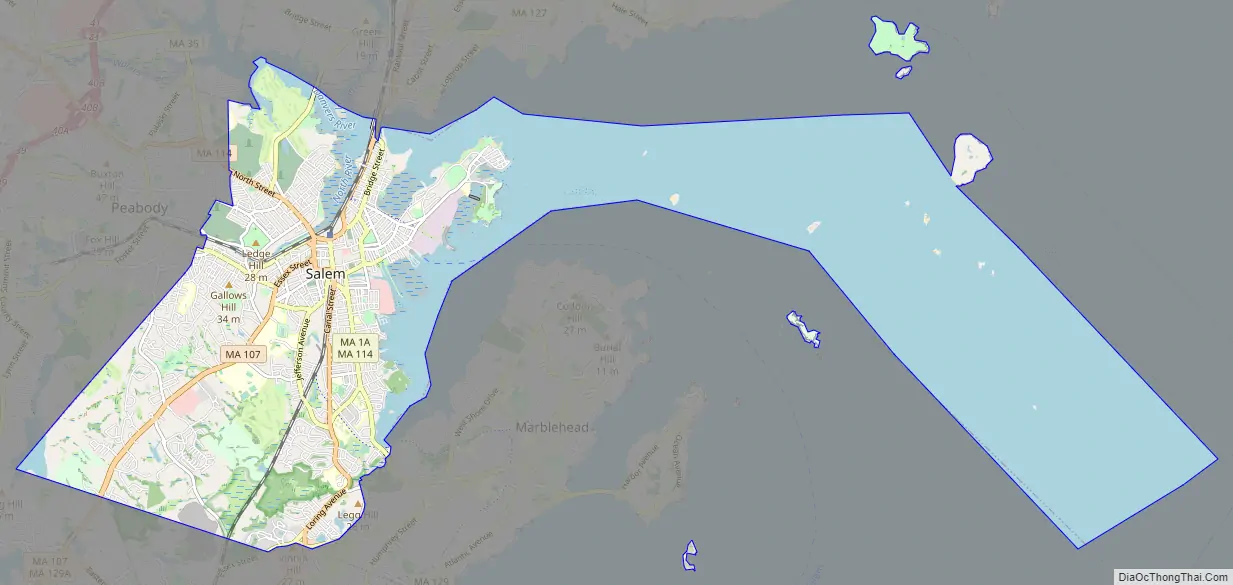
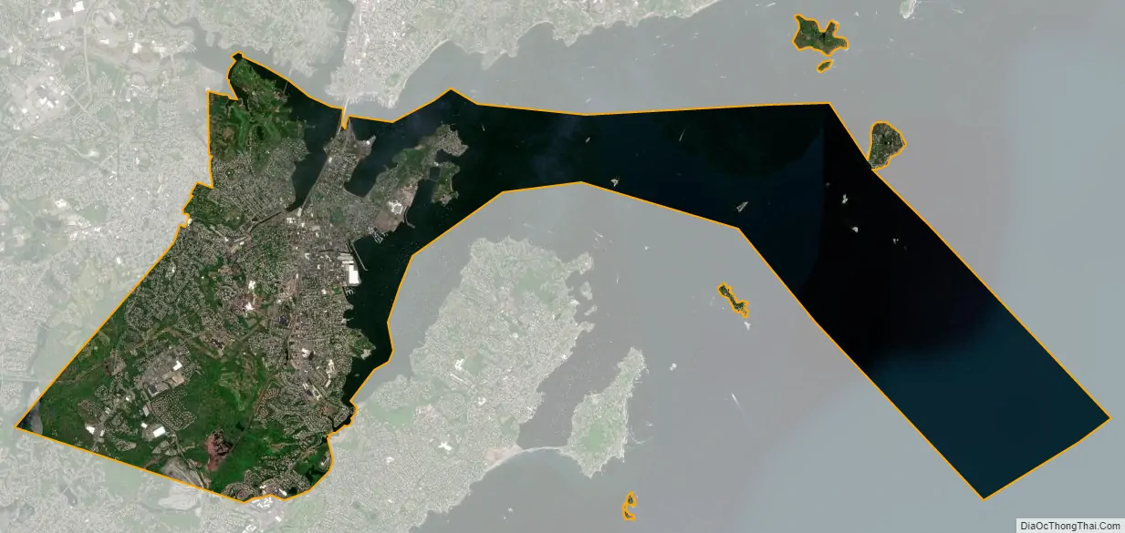
Salem city Satellite Map
Geography
Salem is located at 42°31′1″N 70°53′55″W / 42.51694°N 70.89861°W / 42.51694; -70.89861 (42.516845, −70.898503). According to the United States Census Bureau, the city has a total area of 18.1 square miles (47 km), of which 8.1 square miles (21 km) is land and 9.9 square miles (26 km), or 55.09%, is water. Salem lies on Massachusetts Bay between Salem Harbor, which divides the city from much of neighboring Marblehead to the southeast, and Beverly Harbor, which divides the city from Beverly along with the Danvers River, which feeds into the harbor. Between the two harbors lies Salem Neck and Winter Island, which are divided from each other by Cat Cove, Smith Pool (located between the two land causeways to Winter Island), and Juniper Cove. The city is further divided by Collins Cove and the inlet to the North River. The Forest River flows through the south end of town, along with Strong Water Brook, which feeds Spring Pond at the town’s southwest corner. The town has several parks, as well as conservation land along the Forest River and Camp Lion, which lies east of Spring Pond.
The city is divided by its natural features into several small neighborhoods. The Salem Neck neighborhood lies northeast of downtown, and North Salem lies to the west of it, on the other side of the North River. South Salem is south of the South River, lying mostly along the banks of Salem Harbor southward. Downtown Salem lies 15 miles (24 km) northeast of Boston, 16 miles (26 km) southwest of Gloucester and Cape Ann, and 19 miles (31 km) southeast of Lawrence, the other county seat of Essex County. Salem is bordered by Beverly to the north, Danvers to the northwest, Peabody to the west, Lynn to the south, Swampscott to the southeast, and Marblehead to the southeast. The town’s water rights extend along a channel into Massachusetts Bay between the water rights of Marblehead and Beverly.
Climate
According to the Köppen climate classification, Salem has either a hot-summer humid continental climate (abbreviated Dfa), or a hot-summer humid sub-tropical climate (abbreviated Cfa), depending on the isotherm used.
See also
Map of Massachusetts State and its subdivision: Map of other states:- Alabama
- Alaska
- Arizona
- Arkansas
- California
- Colorado
- Connecticut
- Delaware
- District of Columbia
- Florida
- Georgia
- Hawaii
- Idaho
- Illinois
- Indiana
- Iowa
- Kansas
- Kentucky
- Louisiana
- Maine
- Maryland
- Massachusetts
- Michigan
- Minnesota
- Mississippi
- Missouri
- Montana
- Nebraska
- Nevada
- New Hampshire
- New Jersey
- New Mexico
- New York
- North Carolina
- North Dakota
- Ohio
- Oklahoma
- Oregon
- Pennsylvania
- Rhode Island
- South Carolina
- South Dakota
- Tennessee
- Texas
- Utah
- Vermont
- Virginia
- Washington
- West Virginia
- Wisconsin
- Wyoming