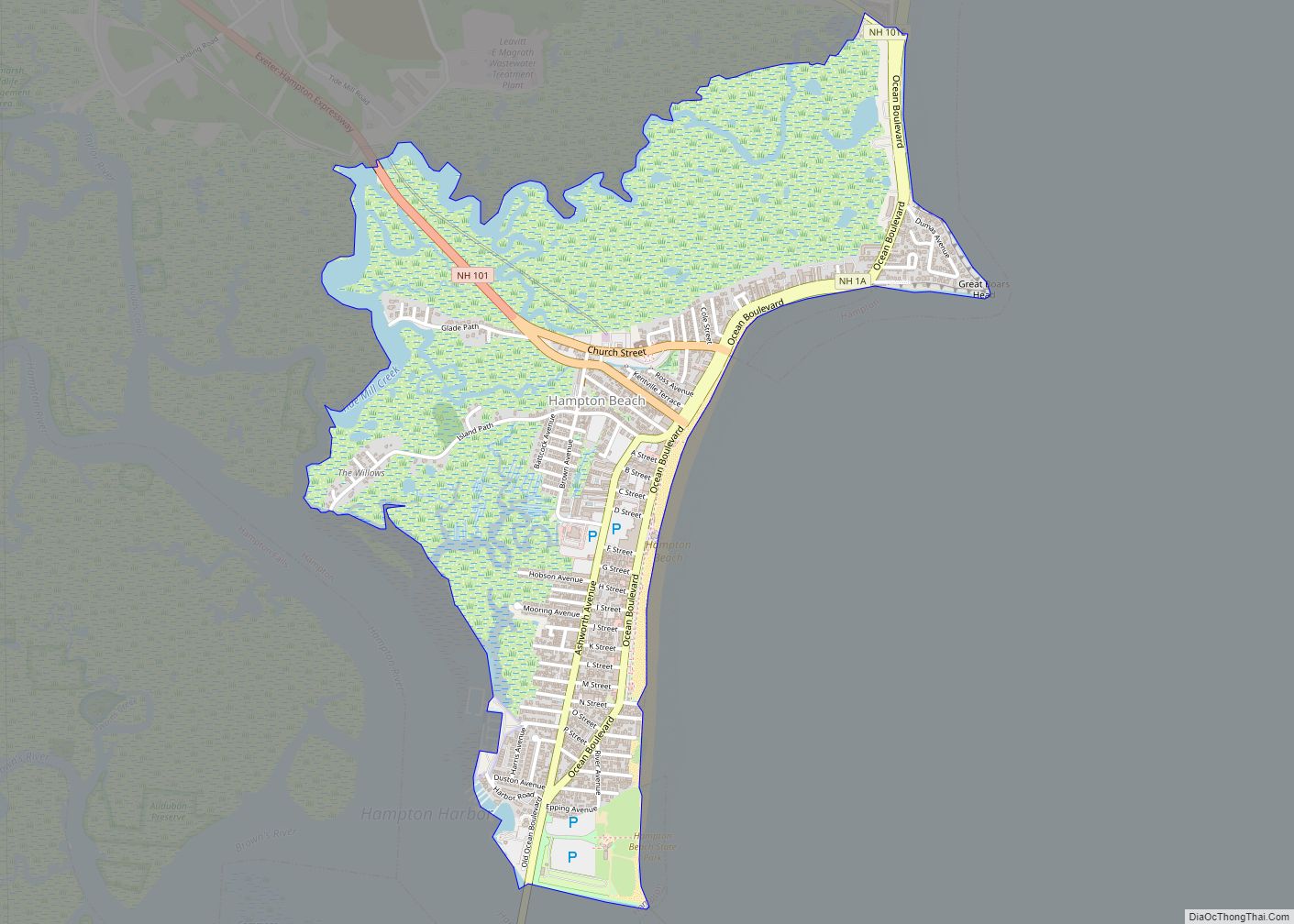
Hampton Beach is a village district, census-designated place, and beach resort in the town of Hampton, New Hampshire, United States, along the Atlantic Ocean. Its population at the 2020 census was 2,598. Hampton Beach is in Rockingham County, about 15 miles (24 km) south of Portsmouth. The community is a popular tourist destination and the busiest beach community in New Hampshire. Ocean Boulevard, the main street along the beach, includes a boardwalk, many shops and businesses, several seasonal hotels, and the Hampton Beach Casino Ballroom, which hosts national acts in the summer. Hampton Beach State Park was named one of four “Superstar” beaches in the United States in 2011, for having had perfect water-quality testing results in each of the previous three years.
| Name: | Hampton Beach CDP |
|---|---|
| LSAD Code: | 57 |
| LSAD Description: | CDP (suffix) |
| State: | New Hampshire |
| County: | Rockingham County |
| Elevation: | 10 ft (3 m) |
| Total Area: | 1.50 sq mi (3.87 km²) |
| Land Area: | 1.27 sq mi (3.30 km²) |
| Water Area: | 0.22 sq mi (0.58 km²) |
| Total Population: | 2,598 |
| Population Density: | 2,042.45/sq mi (788.29/km²) |
| ZIP code: | 03842, 03843 |
| Area code: | 603 |
| FIPS code: | 3333140 |
| GNISfeature ID: | 0867344 |
| Website: | www.hamptonbeach.org |
Online Interactive Map
Click on ![]() to view map in "full screen" mode.
to view map in "full screen" mode.
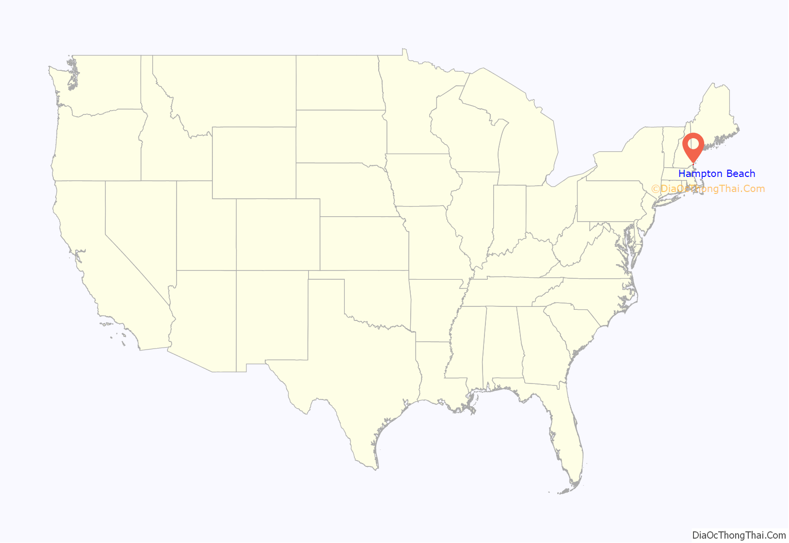
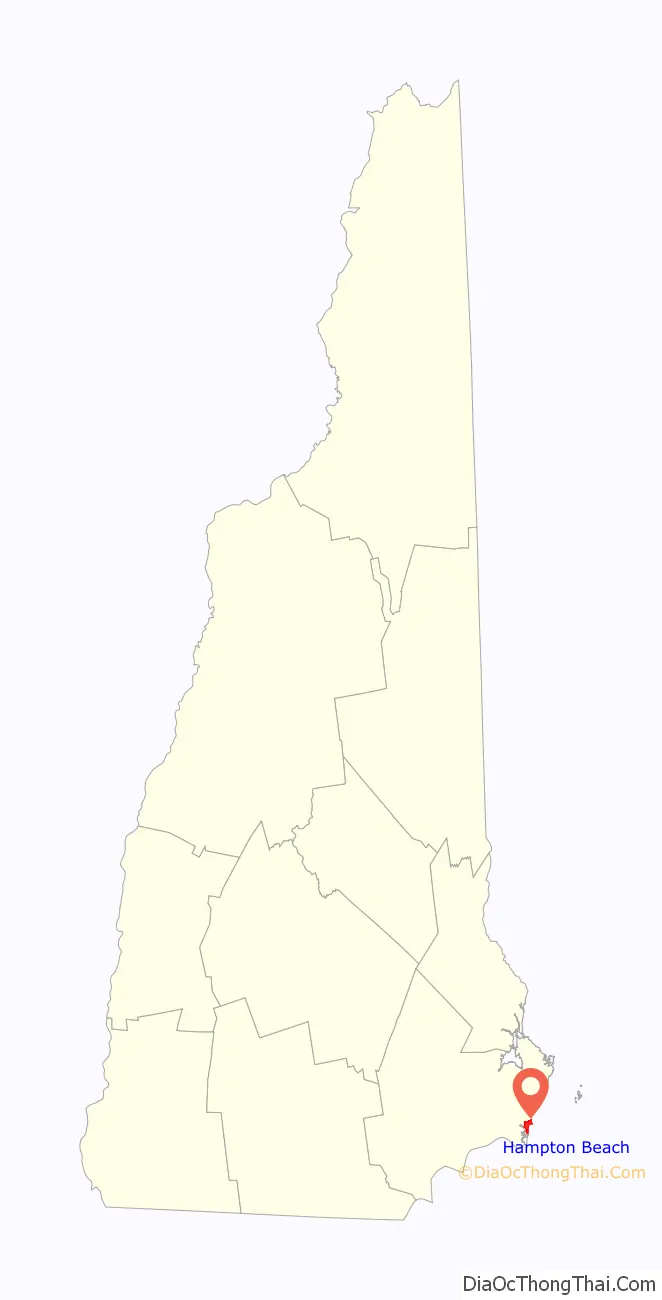
Hampton Beach location map. Where is Hampton Beach CDP?
History
The Hampton Beach Village District was established on June 26, 1907, to provide electric power and water to the summer tourist community. In 1923, the village’s first fire station was built, after two fires destroyed a large section of the beach settlement in 1919 and 1922. The original fire station was razed and replaced in 2014.
On February 26, 2010, a windstorm-fueled fire burned down all the buildings in a block at Hampton Beach, including the Surf Hotel, Happy Hampton Arcade, and Mrs. Mitchell’s Gift Shop. The fire started in the Surf Hotel and was spread to the other buildings by high winds. The cause of this fire is unknown. The area has been rebuilt, with a larger hotel and a new Mrs. Mitchell’s.
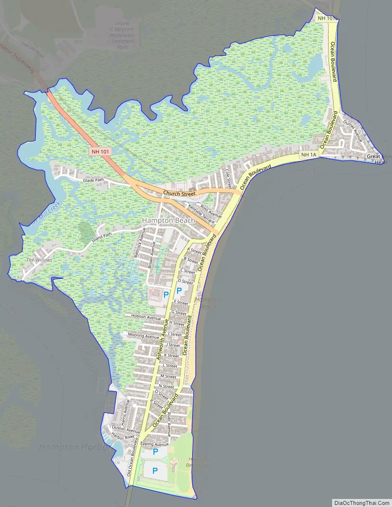
Hampton Beach Road Map
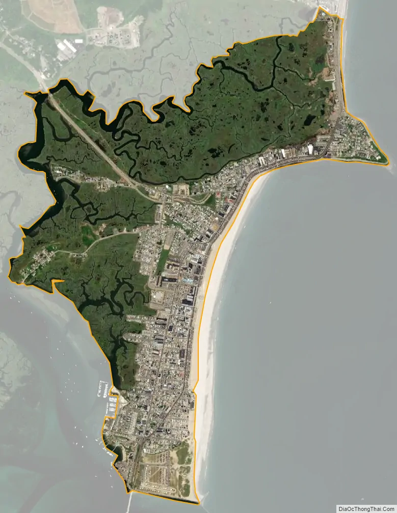
Hampton Beach city Satellite Map
Geography
Most of the resort village lies on a barrier spit separated from the mainland by a large estuary system known as Hampton Harbor. The estuary serves as the mouth of several rivers, the largest being the Hampton River from the northwest. New Hampshire Route 1A serves as the main north-south route through the beach area, connecting the village to Seabrook Beach to the south (across the Hampton Bridge traversing the Hampton Harbor Inlet) and Little Boar’s Head in North Hampton to the north. Access from the west is provided by three roads: New Hampshire Route 101 is the main access point to the densely populated southern resort area from most points west, while Winnacunnet Road (officially New Hampshire Route 101E) provides access to the less developed areas in the northern part of the village near a large salt marsh conservation area. Winnacunnet Road marks the northern edge of the census-designated place, but New Hampshire Route 27, known locally as High Street, marks the northern edge of the resort area.
The heaviest development lies south of the Ashworth-by-the-Sea hotel, located at the eastern terminus of NH 101 where it meets NH 1A, known locally as Ocean Boulevard. From this point south, NH 1A splits into two one-way streets: the southbound Ashworth Avenue, and the northbound Ocean Boulevard. Cross streets through this area run from A Street in the north to M Street in the south. The southern end of the spit is mostly state park, with little to no buildings or development. North of the junction of 101 and 1A, the area is much less developed, dominated mostly by a large salt marsh conservation area, with small businesses and bungalows along Ocean Boulevard (NH 1A). North of Winnacunnet Road (and outside the CDP), a second area of heavier development begins with Kings Highway parallel to Ocean Boulevard, and cross streets numbered from 1st Street in the south to 19th Street in the north. The resort ends at the Windjammer Hotel at its northern end, at the junction of NH 27 and NH 1A.
The census-designated place (CDP) portion of Hampton Beach extends from the Seabrook town line in the south to Winnacunnet Road in the north. The western border, separating it from the Hampton CDP, follows Tide Mill Creek within the Hampton Saltmarsh, and the eastern border is the Atlantic Ocean shoreline. According to the U.S. Census Bureau, the Hampton Beach CDP has a total area of 1.49 square miles (3.87 km), of which 1.27 square miles (3.30 km) are land and 0.22 square miles (0.58 km), or 14.88%, are water.
See also
Map of New Hampshire State and its subdivision: Map of other states:- Alabama
- Alaska
- Arizona
- Arkansas
- California
- Colorado
- Connecticut
- Delaware
- District of Columbia
- Florida
- Georgia
- Hawaii
- Idaho
- Illinois
- Indiana
- Iowa
- Kansas
- Kentucky
- Louisiana
- Maine
- Maryland
- Massachusetts
- Michigan
- Minnesota
- Mississippi
- Missouri
- Montana
- Nebraska
- Nevada
- New Hampshire
- New Jersey
- New Mexico
- New York
- North Carolina
- North Dakota
- Ohio
- Oklahoma
- Oregon
- Pennsylvania
- Rhode Island
- South Carolina
- South Dakota
- Tennessee
- Texas
- Utah
- Vermont
- Virginia
- Washington
- West Virginia
- Wisconsin
- Wyoming