New Jersey is a state situated within both the Mid-Atlantic and Northeastern regions of the United States. It is the most densely populated U.S. state, and is situated at the center of the Northeast megalopolis, the most populous American urban agglomeration. New Jersey is bordered on its north and east by the state of New York; on its east, southeast, and south by the Atlantic Ocean; on its west by the Delaware River and Pennsylvania; and on its southwest by Delaware Bay and the state of Delaware. At 7,354 square miles (19,050 km), New Jersey is the fifth-smallest state in land area, but with close to 9.3 million residents as of the 2020 United States census, its highest decennial count ever, ranks 11th in population. The state capital is Trenton, and the most populous city is Newark. New Jersey is the only U.S. state in which every county is deemed urban by the U.S. Census Bureau, with 13 counties included in the New York metropolitan area, seven counties in the Philadelphia metropolitan area, and with Warren County constituting part of the rapidly industrializing Lehigh Valley metropolitan area.
New Jersey was first inhabited by Paleo-Indians as early as 13,000 B.C.E., with the Lenape being the dominant indigenous group when Europeans arrived in the early 17th century. Dutch and Swedish colonists founded the first European settlements in the state, with the British later seizing control of the region and establishing the Province of New Jersey, named after the largest of the Channel Islands. The colony’s fertile lands and relative religious tolerance drew a large and diverse population. New Jersey was among the Thirteen Colonies that supported the American Revolution, hosting numerous pivotal battles and military commands in the American Revolutionary War. On December 18, 1787, it became the third state to ratify the United States Constitution, and thus be admitted to the Union, and was the first state to ratify the U.S. Bill of Rights on November 20, 1789.
New Jersey remained in the Union during the American Civil War and provided troops, resources, and military leaders. After the war, the state emerged as a major manufacturing center and a leading destination for immigrants, helping drive the Industrial Revolution in the U.S. New Jersey was the site of many industrial, technological, and commercial innovations, including the first town (Roselle) to be illuminated by electricity, the first incandescent light bulb, and the first steam locomotive. Many prominent Americans associated with New Jersey have proven influential nationally and globally, including in academia, advocacy, business, entertainment, government, military, non-profit leadership, and other fields.
New Jersey’s central location in the Northeast megalopolis helped fuel its rapid growth and suburbanization in the second half of the 20th century. At the turn of the 21st century, its economy increasingly diversified, with major sectors including biotechnology, pharmaceuticals, specialized agriculture, and information technology. New Jersey remains a major destination for immigrants and is home to one of the most ethnically diverse and multicultural populations in the world. Echoing historical trends, the state has increasingly re-urbanized, with growth in cities outpacing suburbs since 2008. New Jersey is one of the wealthiest states in the U.S., consistently ranking as one of the top three by median household income. Almost one-tenth of all households, or over 323,000 of 3.3 million, are millionaires, the highest rate of any U.S. state. New Jersey’s public school system consistently ranks at or among the top of all U.S. states. According to climatology research by the U.S. National Oceanic and Atmospheric Administration, New Jersey has been the fastest-warming state by average air temperature over a 100-year period beginning in the early 20th century, due to persistent warming of the North Atlantic Ocean.
| Before statehood: | Province of New Jersey |
|---|---|
| Admitted to the Union: | December 18, 1787 (3rd) |
| Capital: | Trenton |
| Largest city: | Newark |
| Largest metro and urban areas: | New York |
| Elevation: | 250 ft (80 m) |
| Total Area: | 8,722.58 sq mi (22,591.38 km) |
| Area Rank: | 47th |
| Total Population: | 9,288,994 |
| Population Rank: | 11th |
| Population Density: | 1,263.0/sq mi (487.6/km) |
| Population Density Rank: | 1st |
| Median Household Income: | $82,545 |
| Income Rank: | 3rd |
| Demonym(s): | New Jerseyan (official), New Jerseyite |
| USPS abbreviation: | NJ |
| ISO 3166 code: | US-NJ |
| Website: | nj.gov |
Online Interactive Map
Click on ![]() to view map in "full screen" mode.
to view map in "full screen" mode.
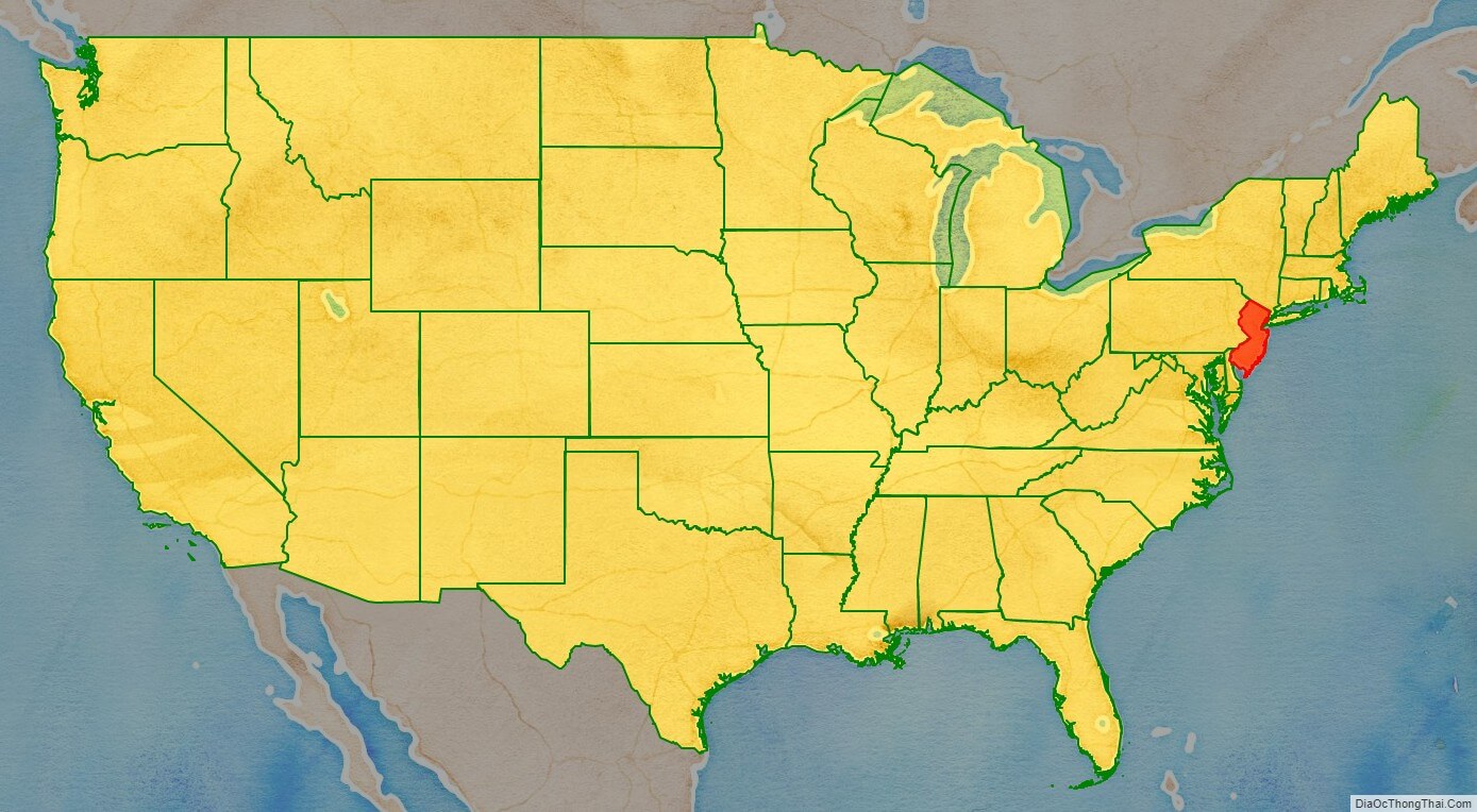
New Jersey location map. Where is New Jersey state?
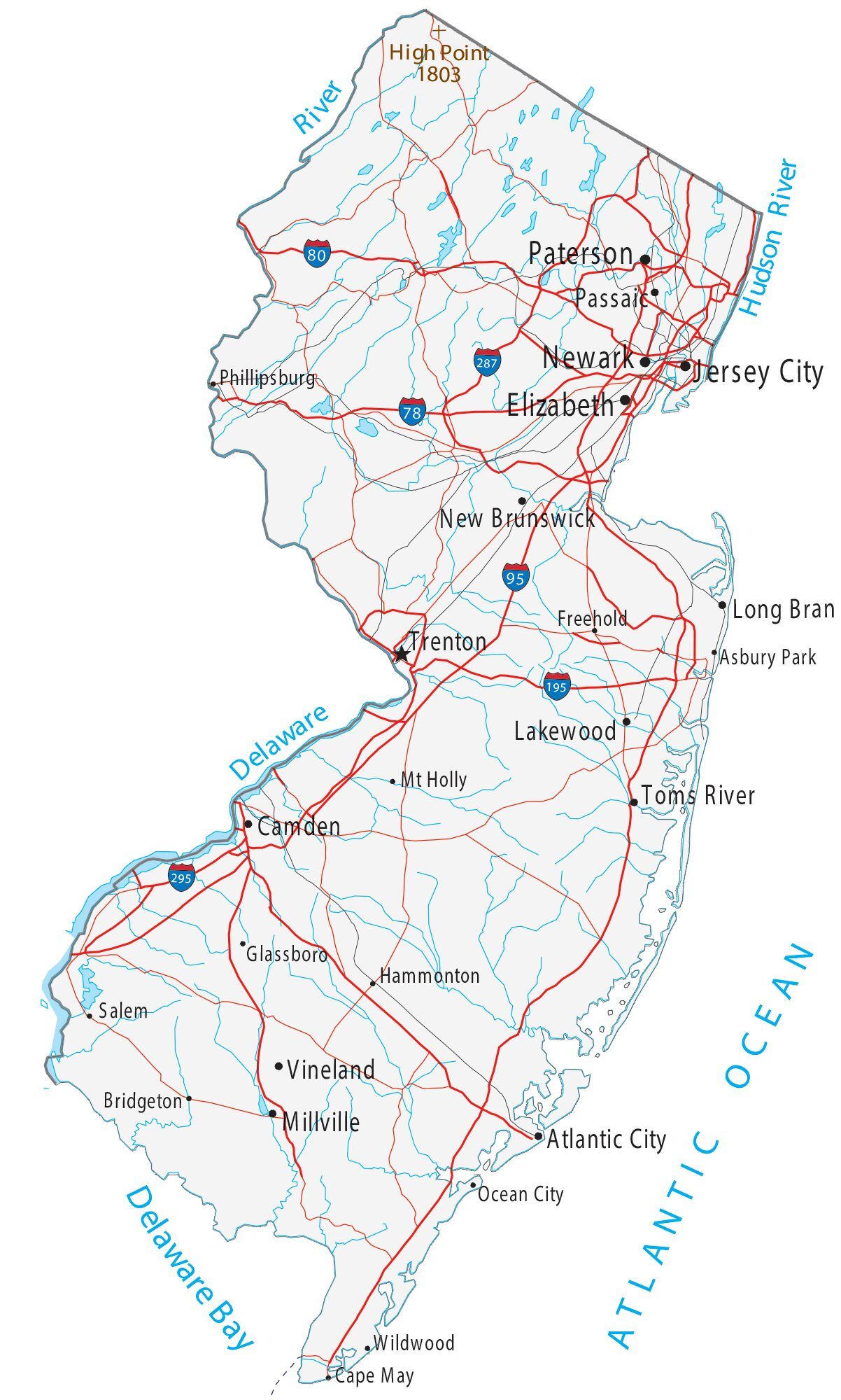
New Jersey Road Map
New Jersey Map – Roads & Cities
New Jersey Street Map
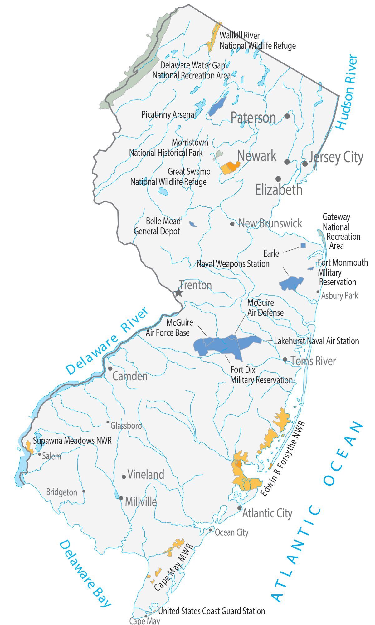
New Jersey State Map – Places and Landmarks
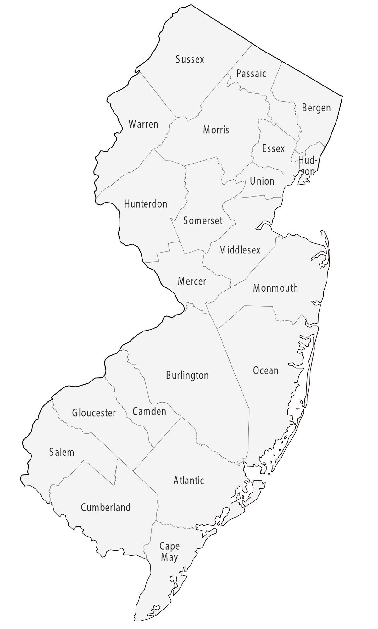
New Jersey Political Map

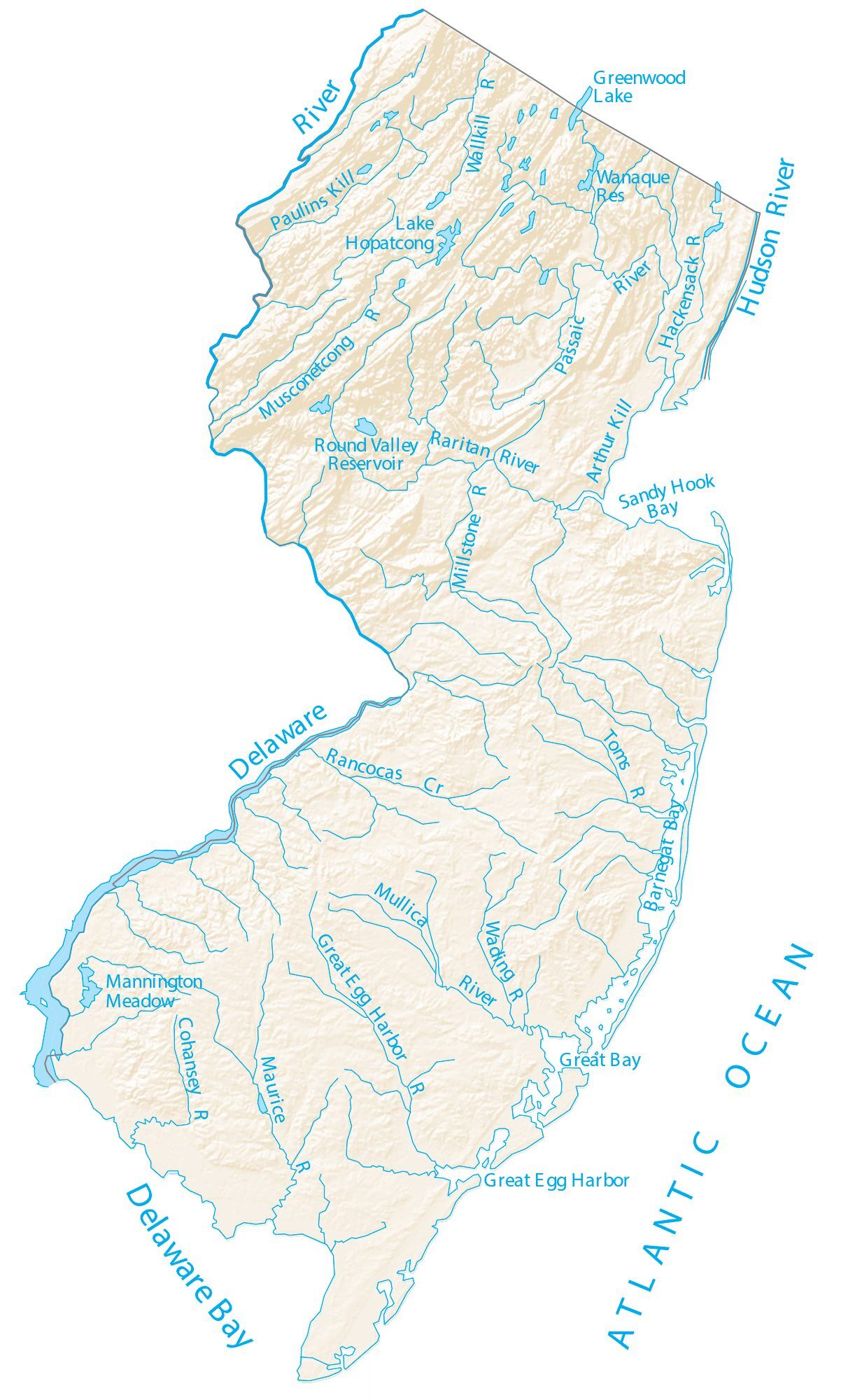
New Jersey Lakes and Rivers Map
Geography
New Jersey is located at the center of the Northeast megalopolis, the most populated American urban agglomeration. It is bordered on the north and northeast by New York (parts of which are across the Hudson River, Upper New York Bay, the Kill Van Kull, Newark Bay, and the Arthur Kill); on the east by the Atlantic Ocean; on the southwest by Delaware across Delaware Bay; and on the west by Pennsylvania across the Delaware River(which is New Jersey’s only straight border).
New Jersey is broadly divided into North, Central, and South geographic regions, although some residents do not consider Central Jersey a region in its own right. Across the regions are five distinct areas divided by natural geography and population concentration. Northeastern New Jersey, often referred to as the Gateway Region, lies closest to Manhattan in New York City, and up to a million residents commute daily into the city for work, many via public transportation. Northwestern New Jersey, often referred to as the Skylands Region, is more wooded, rural, and mountainous. The chief tree of the northern forests is the oak. The Jersey Shore, along the Atlantic Coast in Central and South Jersey, has its own unique natural, residential, and cultural characteristics owing to its location by the ocean. The Delaware Valley includes the southwestern counties of the state, which reside within the Delaware Valley surrounding Philadelphia. The New Jersey Pine Barrens is situated in the southern interior of New Jersey and covered extensively by mixed pine and oak forest; its population density is lower than most of the state.
Despite its heavily urban character and a long history of industrialization, forests cover roughly 45 percent of New Jersey’s land area, or approximately 2.1 million acres, ranking 31st among the 50 U.S. states and six territories.
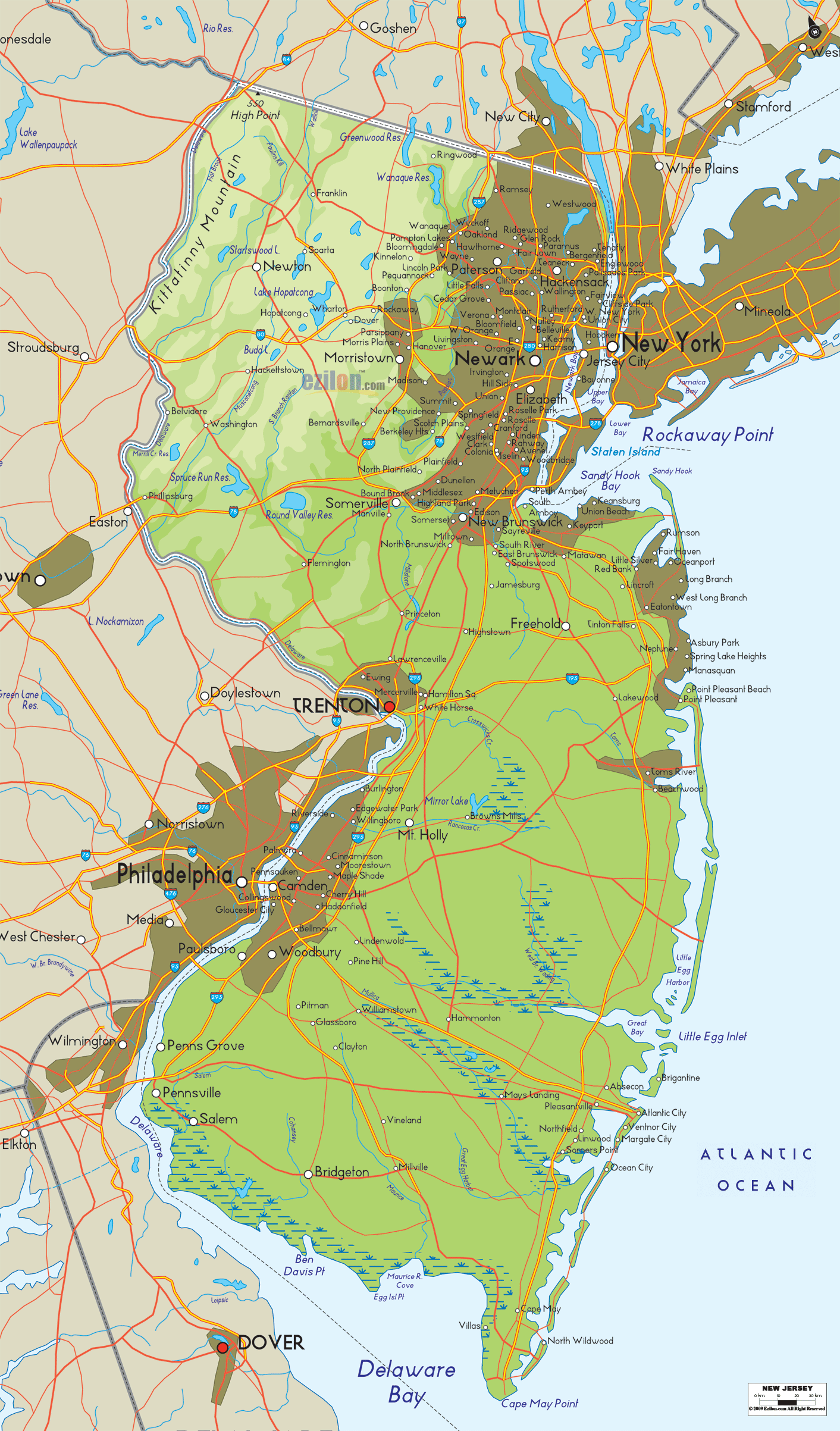
High Point in Montague Township, Sussex County is the state’s highest elevation at 1,803 feet (550 m) above sea level. The state’s highest prominence is Kitty Ann Mountain in Morris County, rising 892 feet (272 m). The Palisades are a line of steep cliffs on the west side of the Hudson River in Bergen and Hudson Counties. Major New Jersey rivers include the Hudson, Delaware, Raritan, Passaic, Hackensack, Rahway, Musconetcong, Mullica, Rancocas, Manasquan, Maurice, and Toms rivers. Due to New Jersey’s peninsular geography, both sunrise and sunset are visible over water from different points on the Jersey Shore.
Prominent geographic features
- Delaware Water Gap
- Great Bay
- Great Swamp National Wildlife Refuge
- Highlands
- Hudson Palisades
- Jersey Shore
- On the shore, New Jersey hosts the highest number of oceanside boardwalks in the United States.
- Meadowlands
- New Jersey Pine Barrens
- Ramapo Mountain
- South Mountain
Climate
There are two climatic conditions in the state. The south, central, and northeast parts of the state have a humid subtropical climate; while the northwest has a humid continental climate (microthermal), with much cooler temperatures due to higher elevation and greater distance from the Atlantic Ocean. New Jersey receives between 2,400 and 2,800 hours of sunshine annually.
Climate change is affecting New Jersey faster than much of the rest of the United States. Climatologists at the U.S. National Oceanic and Atmospheric Administration have concluded that New Jersey has been the fastest-warming state by average air temperature over a 100-year period beginning in the early 20th century.
Summers are typically hot and humid, with statewide average high temperatures of 82–87 °F (28–31 °C) and lows of 60–69 °F (16–21 °C); however, temperatures exceed 90 °F (32 °C) on average 25 days each summer, exceeding 100 °F (38 °C) in some years. Winters are usually cold, with average high temperatures of 34–43 °F (1–6 °C) and lows of 16 to 28 °F (−9 to −2 °C) for most of the state, but temperatures can, for brief periods, fall below 10 °F (−12 °C) and sometimes rise above 50 °F (10 °C). Northwestern parts of the state have significantly colder winters with sub-0 °F (−18 °C) being an almost annual occurrence. Spring and autumn may feature wide temperature variations, with lower humidity than summer. The USDA Plant Hardiness Zone classification ranges from 6 in the northwest of the state, to 7B near Cape May. All-time temperature extremes recorded in New Jersey include 110 °F (43 °C) on July 10, 1936, in Runyon, Middlesex County and −34 °F (−37 °C) on January 5, 1904, in River Vale, Bergen County.
Average annual precipitation ranges from 43 to 51 inches (1,100 to 1,300 mm), spread uniformly throughout the year. Average snowfall per winter season ranges from 10–15 inches (25–38 cm) in the south and near the seacoast, 15–30 inches (38–76 cm) in the northeast and central part of the state, to about 40–50 inches (1.0–1.3 m) in the northwestern highlands, but this often varies considerably from year to year. Precipitation falls on an average of 120 days a year, with 25 to 30 thunderstorms, most of which occur during the summer.
During winter and early spring, New Jersey can experience “nor’easters”, which are capable of causing blizzards or flooding throughout the northeastern United States. Hurricanes and tropical storms, tornadoes, and earthquakes are rare; the state was impacted by a hurricane in 1903, Tropical Storm Floyd in 1999, and Hurricane Sandy in 2012, which made landfall in the state with top winds of 90 mph (145 km/h).
New Jersey Physical Map
New Jersey Topographic Map
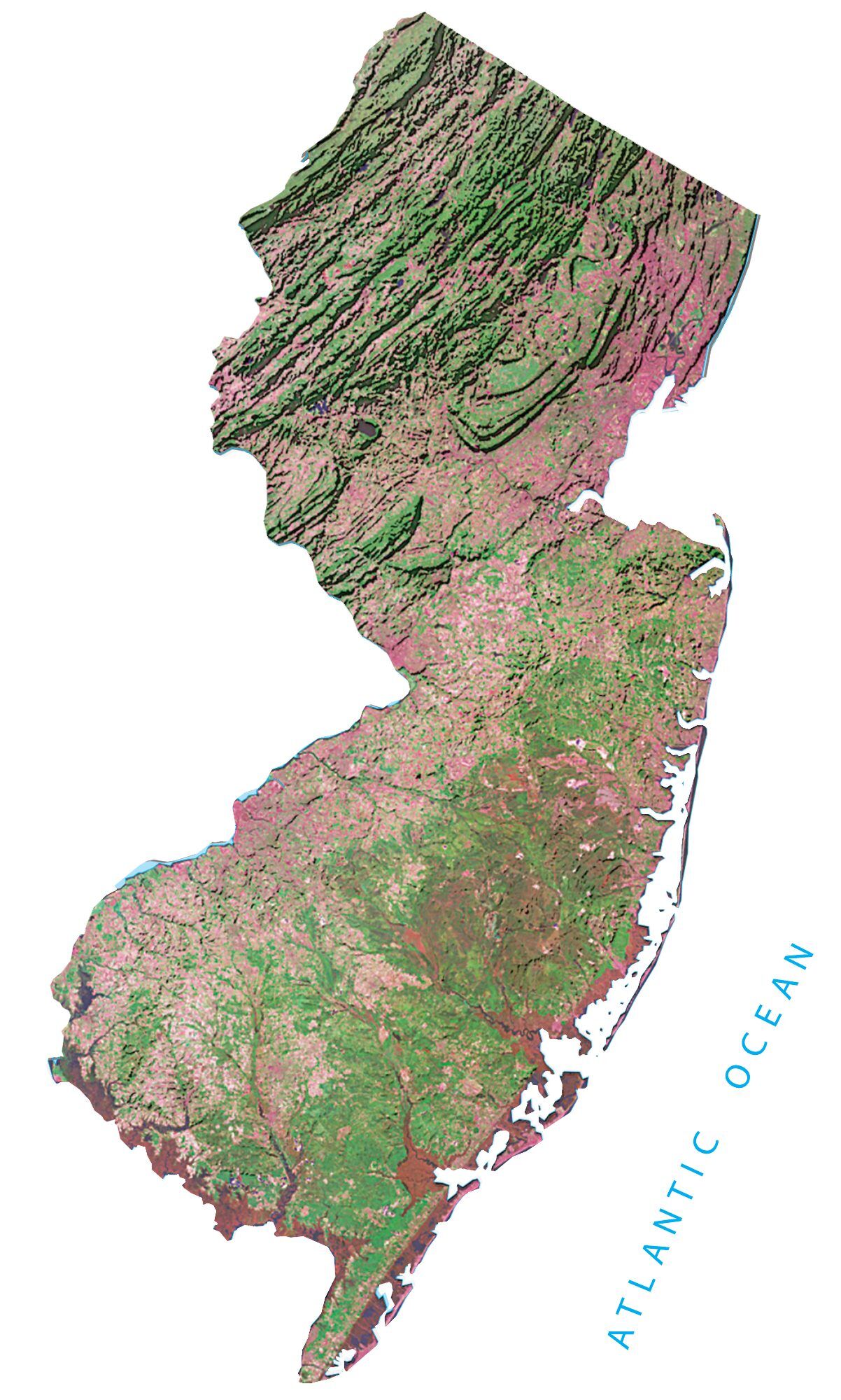
New Jersey Satellite Map
Others printable maps
New Jersey Outline Map
Blank New Jersey County Map
See also
Map of New Jersey State and its subdivision: Map of other states:- Alabama
- Alaska
- Arizona
- Arkansas
- California
- Colorado
- Connecticut
- Delaware
- District of Columbia
- Florida
- Georgia
- Hawaii
- Idaho
- Illinois
- Indiana
- Iowa
- Kansas
- Kentucky
- Louisiana
- Maine
- Maryland
- Massachusetts
- Michigan
- Minnesota
- Mississippi
- Missouri
- Montana
- Nebraska
- Nevada
- New Hampshire
- New Jersey
- New Mexico
- New York
- North Carolina
- North Dakota
- Ohio
- Oklahoma
- Oregon
- Pennsylvania
- Rhode Island
- South Carolina
- South Dakota
- Tennessee
- Texas
- Utah
- Vermont
- Virginia
- Washington
- West Virginia
- Wisconsin
- Wyoming
