Beatty (/ˈbeɪti/ BAYT-ee) is an unincorporated town along the Amargosa River in Nye County in the U.S. state of Nevada. U.S. Route 95 runs through the town, which lies between Tonopah, about 90 miles (140 km) to the north and Las Vegas, about 120 miles (190 km) to the southeast. State Route 374 connects Beatty to Death Valley National Park, about 8 miles (13 km) to the west.
Before the arrival of non-indigenous people in the 19th century, the region was home to groups of Western Shoshone. Established in 1905, the community was named after Montillus (Montillion) Murray “Old Man” Beatty, who settled on a ranch in the Oasis Valley in 1896 and became Beatty’s first postmaster. With the arrival of the Las Vegas and Tonopah Railroad in 1905, the town became a railway center for the Bullfrog Mining District, including mining towns such as nearby Rhyolite. Starting in the 1940s, Nellis Air Force Base and other federal installations contributed to the town’s economy as did tourism related to Death Valley National Park and the rise of Las Vegas as an entertainment center.
Beatty is home to the Beatty Museum and Historical Society and to businesses catering to tourist travel. The ghost town of Rhyolite and the Goldwell Open Air Museum (a sculpture park), are both about 4 miles (6 km) to the west, and Yucca Mountain and the Nevada Test Site are about 18 miles (29 km) to the east.
| Name: | Beatty CDP |
|---|---|
| LSAD Code: | 57 |
| LSAD Description: | CDP (suffix) |
| State: | Nevada |
| County: | Nye County |
| Founded: | 1905; 118 years ago (1905) |
| Elevation: | 3,307 ft (1,008 m) |
| Total Area: | 17.70 sq mi (45.85 km²) |
| Land Area: | 17.68 sq mi (45.80 km²) |
| Water Area: | 0.02 sq mi (0.06 km²) |
| Total Population: | 880 |
| Population Density: | 49.77/sq mi (19.22/km²) |
| ZIP code: | 89003 |
| Area code: | 775 |
| FIPS code: | 3205100 |
| GNISfeature ID: | 0845356 |
Online Interactive Map
Click on ![]() to view map in "full screen" mode.
to view map in "full screen" mode.
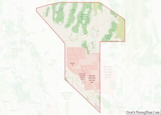
Beatty location map. Where is Beatty CDP?


History
Before the arrival of non-indigenous explorers, prospectors, and settlers, Western Shoshone in the Beatty area hunted game and gathered wild plants in the region. It is estimated that the 19th-century population density of the Indians near Beatty was one person per 44 square miles (110 km). By the middle of the century, European diseases had greatly reduced the Indian population, and incursions by newcomers had disrupted the native traditions. In about 1875, the Shoshone had six camps, with a total population of 29, along the Amargosa River near Beatty. Some of the survivors and their descendants continued to live in or near Beatty, while others moved to reservations at Walker Lake, Reese River, Duckwater, or elsewhere.
Beatty is named after “Old Man” Montillus (Montillion) Murray Beatty, a Civil War veteran and miner who bought a ranch along the Amargosa River just north of the future community and became its first postmaster in 1905. The community was laid out in 1904 or 1905 after Ernest Alexander “Bob” Montgomery, owner of the Montgomery Shoshone Mine near Rhyolite, decided to build the Montgomery Hotel in Beatty. Montgomery was drawn to the area, known as the Bullfrog Mining District, because of a gold rush that began in 1904 in the Bullfrog Hills west of Beatty.
During Beatty’s first year, wagons pulled by teams of horses or mules hauled freight between the Bullfrog district (that included the towns of Rhyolite, Bullfrog, Gold Center, Transvaal, and Springdale) and the nearest railroad, in Las Vegas, and by the middle of 1905, about 1,500 horses were engaged in this business. In October 1906, the Las Vegas and Tonopah Railroad (LV&T) began regular service to Beatty; in April 1907, the Bullfrog Goldfield Railroad (BG) reached the community, and the Tonopah and Tidewater (T&T) line added a third railroad in October 1907. The LV&T ceased operations in 1918, the BG in 1928, and the T&T in 1940. Until the railroads abandoned their lines, Beatty served as the railhead for many mines in the area, including a fluorspar mine on Bare Mountain, to the east.
Beatty’s first newspaper was the Beatty Bullfrog Miner, which began publishing in 1905 and went out of business in 1909. The Rhyolite Herald was the region’s most important paper, starting in 1905 and reaching a circulation of 10,000 by 1909. It ceased publication in 1912, and the Beatty area had no newspaper from then until 1947. The Beatty Bulletin, a supplement to the Goldfield News, was published from then through 1956.
Beatty’s population grew slowly in the first half of the 20th century, rising from 169 in 1929 to 485 in 1950. The first reliable electric company in the community, Amargosa Power Company, began supplying electricity in about 1940. Phone service arrived during World War II, and the town installed a community-wide sewer system in the 1970s. When a new mine opened west of Beatty in 1988, the population briefly surged from about 1,000 to between 1,500 and 2,000 by the end of 1990. Since the mine’s closing in 1998, the population has fallen again to near its former level.
Beatty Road Map
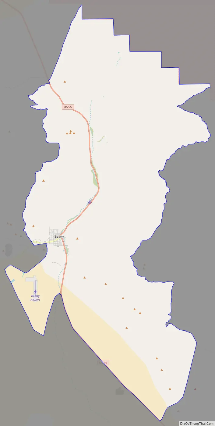
Beatty city Satellite Map

Geography
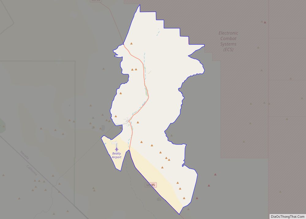
Beatty lies along U.S. Route 95 between Tonopah, about 90 miles (140 km) to the north, and Las Vegas, about 120 miles (190 km) to the southeast. State Route 374 connects Beatty to Death Valley National Park, about 8 miles (13 km) to the west. Yucca Mountain and the Nevada Test Site are about 18 miles (29 km) to the east. The most densely populated part of the census-designated place (CDP) of Beatty is at 36°54′34″N 116°45′16″W / 36.90944°N 116.75444°W / 36.90944; -116.75444 (36.909337, −116.754531), although the CDP extends well beyond this urban center. According to the United States Census Bureau, the CDP has a total area of 175.6 square miles (455 km), all land. The most populated area lies at 3,307 feet (1,008 m) above sea level between Beatty Mountain and Bare Mountain to the east and the Bullfrog Hills to the west. The Amargosa River, an intermittent river that ends in Death Valley, flows on the surface through part of the CDP but has not been counted as water in the Census Bureau statistics.
Nevada’s main climatic features are bright sunshine, low annual precipitation, heavy snowfall in the higher mountains, clean, dry air, and large daily temperature ranges. Strong surface heating occurs by day and rapid cooling by night, and usually even the hottest days have cool nights. The average percentage of possible sunshine in southern Nevada is more than 80 percent. Sunshine and low humidity in this region account for an average evaporation, as measured in evaporation pans, of more than 100 inches (2,500 mm) of water a year.
Beatty receives only 5.71 inches (145 mm) of precipitation a year. Precipitation of at least .01 inches (0.25 mm) falls on an average of 21 days annually. The wettest year was 1941 with 11.89 in (302 mm) and driest year was 1953 with 0.69 in (18 mm). The monthly daily average temperature ranges from 41.1 °F (5.1 °C) in December to 80.2 °F (26.8 °C) in July. On average, there are 26 days of 100 °F (38 °C)+ highs, 97 days of 90 °F (32 °C)+, and 38 days where the high remains at or below 50 °F (10 °C); the average window for freezing temperatures is November 2 to April 6. Snow is uncommon and measurable (≥0.1 in or 0.25 cm) amounts occur in less than 60 of seasons. The highest recorded temperature was 115 °F (46 °C) on June 11, 1961, and the lowest was 1 °F (−17 °C) on February 2, 1933.
See also
Map of Nevada State and its subdivision: Map of other states:- Alabama
- Alaska
- Arizona
- Arkansas
- California
- Colorado
- Connecticut
- Delaware
- District of Columbia
- Florida
- Georgia
- Hawaii
- Idaho
- Illinois
- Indiana
- Iowa
- Kansas
- Kentucky
- Louisiana
- Maine
- Maryland
- Massachusetts
- Michigan
- Minnesota
- Mississippi
- Missouri
- Montana
- Nebraska
- Nevada
- New Hampshire
- New Jersey
- New Mexico
- New York
- North Carolina
- North Dakota
- Ohio
- Oklahoma
- Oregon
- Pennsylvania
- Rhode Island
- South Carolina
- South Dakota
- Tennessee
- Texas
- Utah
- Vermont
- Virginia
- Washington
- West Virginia
- Wisconsin
- Wyoming